Oracle Logo
84
Oracle Logo
Transcript of Oracle Logo

Oracle Logo

Tecnologías Espaciales de ORACLETecnologías Espaciales de ORACLE
Carlos Niño
[email protected]@geospatial.com.co
1
TópicosTópicos
• Entender como utilizar tecnologías espacialesEntender como utilizar tecnologías espaciales de ORACLE
• Principios Tecnológicos de manejo de• Principios Tecnológicos de manejo de información geográfica de ORACLE
C í i• Características
• Locator, Spatial, Mapviewer, Mapbuilder, LRS, 3D y más.

Evolucion de GIS
Application
MonolithicGIS
ProprietaryFiles
DBMSTradicional
Spatial Middleware
Application
ProprietaryAPIs
DatabaseCon
funcionalidadEspacial
Map Server
Application
OpenAPIs
El pasado Hoy
Standalone MiddlewareProprietario
PlataformaInternet
DatabaseTradicional
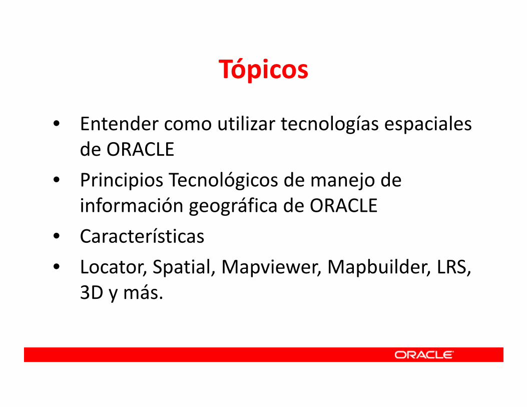
Oracle10g Spatial
Spatial Indexing
Accesso rapidoa su data espacial
Analisis Espacial con SQL
Oracle11g Spatial - Funcionalidad
SELECT a.nombre_de_cliente, a.numero_de_telefonoFROM clientes_de_seguro aWHERE sdo_within_distance( a.geom, via_de_huracan_geom, ‘distance = 20 unit = km’) = ‘TRUE’;
Spatial Data Types
Todo dato espacial almacenado en la base de datos
Points
Polygons
Lines
f1
f2n1
n2
e1
e2e3
e4

Spatial Data Types
• Puntos• Lineas• Poligonos• Poligonos con huecos• Circulos• Arcos• Rectangulos• Elementos Compound
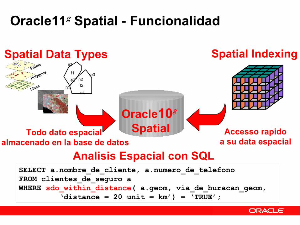
R‐Tree – Índice EspacialR Tree Índice Espacial
• Cual de millones de calles tiene interacción con esta región?g
• Primero compara geometrías simplificadas – o rectángulos
• Aplica optimización interior – Solo compara coordenadas cuando es necesario

Data Espacial en Tablas de Oracle
Fisher Circle
85th St.
Coop Court
CallesCLAVE
1
2
3
MATERIA
Asfalto
Asfalto
Asfalto
NOMBRE
Fisher Cir.
Coop Ct.
85Th St.
VIAS
4
2
2
GEOMETRIA

R-Tree – Indice Espacial
• En el indice, cada geometria esta simplificada como un rectangulo
• Mas rapido comparar rectangulos• Filtro primario solo compara simplificaciones• Filtro secundario solo compara lo resultados de un filtro
primario
SpatialLayer
PrimaryFilter
R-TreeSpatialIndex
ReducedData Set
SecondaryFilter
SpatialOperators
ResultSet

Operadores Espaciales
• Mucha funcionalidad con operadores
• Implementado como extensiones a SQL• Operadores Topologicos
– Inside Contains– Touch Disjoint– Covers Covered By– Equal Overlap Boundary
• Operadores de Distancia– Within Distance– Nearest Neighbor
Inside
500 meters
Within Distance

Analisis Espacial Con SQL
SQL> SELECT a.building_id 2> FROM base_buildings a, 3> base_buildings b 4> WHERE b.building_id = 902 5> AND MDSYS.SDO_WITHIN_DISTANCE( 6> a.Location, b.Location, 7> ‘distance=500 unit=meter’) 8> = ‘TRUE’;
Encuentra edificios a 500 metros del edificio #902
500 meters
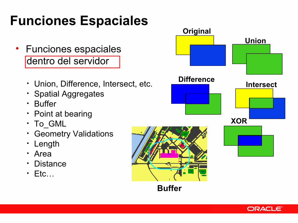
Funciones Espaciales
• Funciones espaciales dentro del servidor
• Union, Difference, Intersect, etc.• Spatial Aggregates• Buffer• Point at bearing• To_GML• Geometry Validations• Length• Area• Distance• Etc…
Union
XOR
Intersect
Original
Difference
Buffer
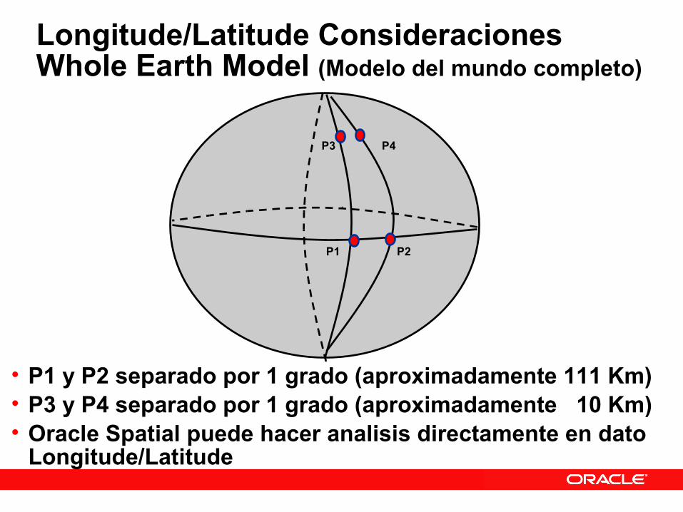
Longitude/Latitude ConsideracionesWhole Earth Model (Modelo del mundo completo)
• P1 y P2 separado por 1 grado (aproximadamente 111 Km)• P3 y P4 separado por 1 grado (aproximadamente 10 Km)• Oracle Spatial puede hacer analisis directamente en dato
Longitude/Latitude
P1 P2
P3 P4
Coordinate Systems
• Soporte para el modelo del mundo completo (latitude/longitude o “whole Earth model”)
• Calculos elipticos• Calculos precisos para area y distancia (soporte para unidades)• Soporte para geometrias que cruzan los polos o el meridiano 180
• Soporte para dato proyectado• Calculos cartesianos• Soporte para muchas sistemas: UTM, State Plane, y mucho mas…
• Soporte para data que no tiene relacion al mundo, por ejemplo, sistema local (en centimetros) para piezas de un avion
• Suporte para EPSG – Oracle 10g Version 2 en adelante
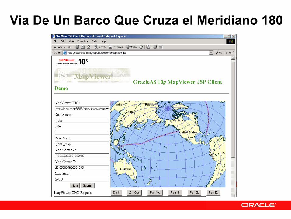
Via De Un Barco Que Cruza el Meridiano 180

Oracle SpatialLinear Referencing Systems
(LRS)

Que es Linear Referencing (LRS)?
(5,10,0) (30,10,27)
(15,5,11.2) (40,5,38)
(50,15,53.8)
(55,20,60)
(45,10,44)
Usado en muchas aplicaciones de GIS, como:• transporte (red de calles)• utilities (tuberia de petroleo, lineas electricas)
Kilometro 0 Kilometro 27
Kilometro 60

LRS Concepts
(5,10,0) (30,10,27)
(15,5,11.2) (40,5,38)
(50,15,53.8)
(55,20,60)
(45,10,44)
Corte de medida 5 a 20“Dynamic Segmentation”
(53,18) queda en medida 57.52“Locate Point”

Pipeline Asset Management ExampleSystem requirements
– Linear reference each section of the pipeline and store: associated diameters locations valve locations
PIPE_ID GEOMETRY INSTALL_DATESUS1105 lrs geom 05-Feb-1997SUS1106SUS1107
lrs geomlrs geom
08-Feb-199709-Feb-1997
...
Pipeline Table
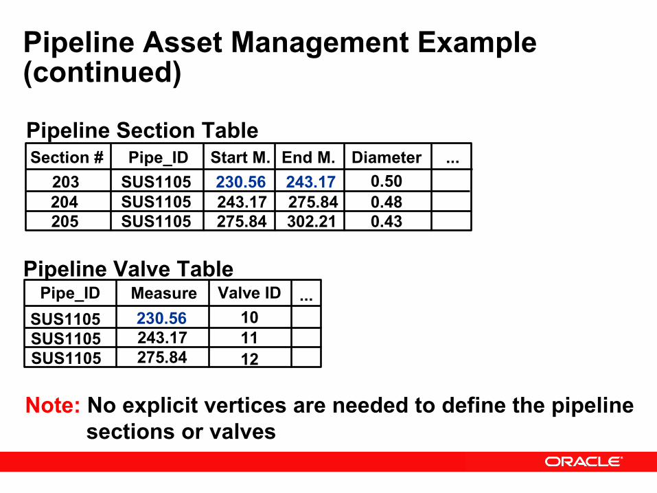
Pipeline Asset Management Example (continued)
Pipe_ID Measure Valve IDSUS1105 230.56 10SUS1105SUS1105
243.17275.84
1112
...
Section # Pipe_ID Start M. End M. Diameter203 SUS1105 230.56 243.17 0.50204205
SUS1105SUS1105
243.17275.84
275.84302.21
0.480.43
...Pipeline Section Table
Pipeline Valve Table
Note: No explicit vertices are needed to define the pipeline sections or valves

• US Airspace Boundary Crossing Application• Oracle Spatial functions to calculate intersection of flight paths and
US airspaces. • Linear Referencing to interpolate the time and altitude for entry/exit
points of US airspace.• Accurately charge foreign carriers for the amount of time in US
airspace.(Longitude, Latitude, Altitude, Time)
Actual radar blip
Computed(Lon/Lat, Alt, Time)
LRS Application – Oracle Spatial
Oracle SpatialSpatial Aggregate Functions

Spatial Aggregate Functions - Ejemplo
Genera el estado de New York, agregando condadosSELECT SDO_AGGR_UNION(sdo_aggr_type(a.geometry, 0.5)FROM countiesWHERE state = 'New York';

SDO_AGGR_CONVEXHULL
Pozos sin contaminacion
Pozos contaminados
• Imagina un elastico alrededor de pozos contaminados• Dinamicamente genera una region nueva• Mas analisis con la region nueva, por ejemplo:
• Busca empresas quimicas dentro de 10 km al limite de la region nueva

Companeros de Oracle Spatial Geospatial Tool Providers
Specialty Systems Integrators Data Providers
NAVIGATE

Oracle Spatial 10g New Features Summary
• GeoRaster data type• Persistent Topology data type• Network Data Model• Spatial Analysis and Mining• Geocoder in the database• Routing Engine
Oracle SpatialGeoRaster
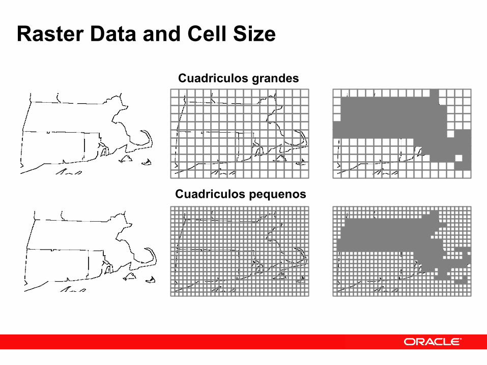
Raster Data and Cell Size
Cuadriculos grandes
Cuadriculos pequenos

Raster/Vector DiferenciasVector Data Vector Coordinates Raster Data
-74.1651749, 41.339141
-74.1651749, 41.339141,-73.4284481, 40.678193,-72.9792214, 41.686228
-74.1651749, 41.339141,-74.1651749, 39.559004,-72.9792214, 39.559004,-72. 9792214, 41.339141
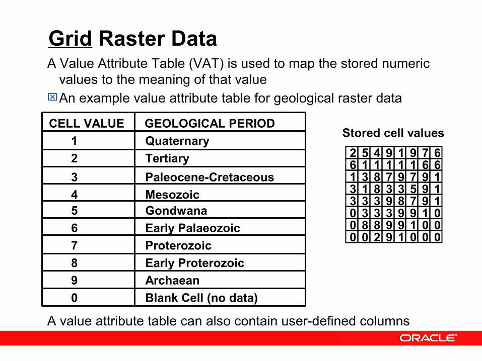
Grid Raster DataA Value Attribute Table (VAT) is used to map the stored numeric
values to the meaning of that valueAn example value attribute table for geological raster data
A value attribute table can also contain user-defined columns
Stored cell values
6 1 1 1 1 6611 3 8 7 9 1973 1 8 3 3 1953 3 3 9 8 1970 3 3 3 9 0190 8 8 9 9 0010 0 2 9 1 000
2 5 4 9 1 679
CELL VALUE GEOLOGICAL PERIOD 1 Quaternary 2 Tertiary 3 Paleocene-Cretaceous 4 Mesozoic 5 Gondwana 6 Early Palaeozoic 7 Proterozoic 8 Early Proterozoic 9 Archaean 0 Blank Cell (no data)

Grid Raster Data
A COLORMAP table is used to map the stored numeric values to the display characteristics of that value
An example COLORMAP table for geological raster data
6 1 1 1 1 6611 3 8 7 9 1973 1 8 3 3 1953 3 3 9 8 1970 3 3 3 9 0190 8 8 9 9 0010 0 2 9 1 000
2 5 4 9 1 679CELL VALUE Red Green Blue
1 255 255 0 2 82 123 67 3 142 230 98 4 96 121 228 5 145 231 243 6 255 51 0 7 203 188 224 8 195 135 75 9 204 102 255 0 0 0 0
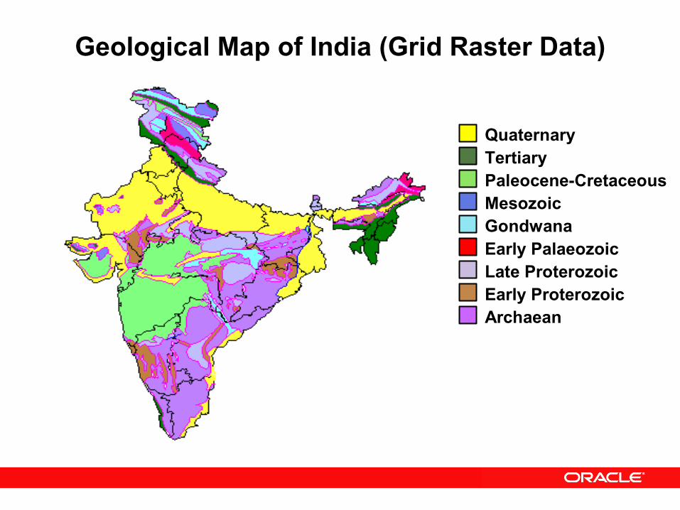
Geological Map of India (Grid Raster Data)
QuaternaryTertiaryPaleocene-CretaceousMesozoicGondwanaEarly PalaeozoicLate ProterozoicEarly ProterozoicArchaean

Raster Data Concepts – (Digital Imagery)
• Digital Imagery - a specialized type of raster dataExamples include:
Satellite imagery Airborne photographs others…
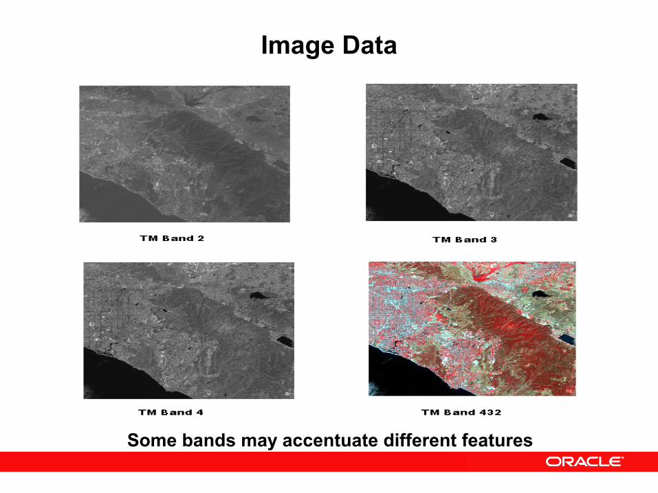
Image Data
Some bands may accentuate different features
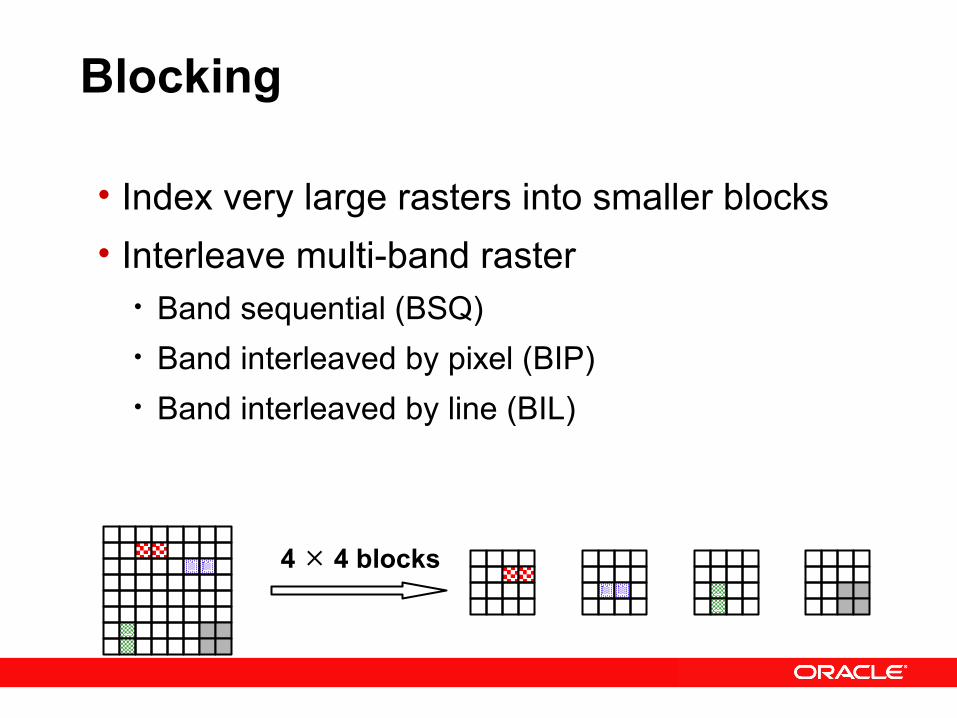
Blocking
• Index very large rasters into smaller blocks• Interleave multi-band raster
• Band sequential (BSQ)• Band interleaved by pixel (BIP)• Band interleaved by line (BIL)
4 4 blocks

Pyramids
Pyramid level 0(raw data)
Pyramid level 1
Pyramid level 2
Pyramidlevel

GeoRaster: Compression
• Natively support two industry standard compression techniques • JPEG (lossy)
– JPEG-B (abbreviated baseline JPEG format)– JPEG-F (full-format baseline JPEG format)
• DEFLATE (lossless)– (a.k.a. ZIP)
• All GeoRaster operations work on compressed/uncompressed GeoRaster objects• Automatic decompression on sub-set operations

Advanced New FeatureGeocoder• Geocoding Engine included in the database• Generates latitude/longitude (points) from address• Supports:
• International addressing standardization• Formatted and unformatted addresses• Transaction and batch capabilities
• Base data available from NAVTEQ & TeleAtlas• Navteq partners (ADCI)• Download sample data from ADCI
• Servlet model – new in 10g Release 2• Regional partners around the world, for example Gempi for
Brasil support
Advanced New FeatureRouter
• Routing algorithms included in the database• Generates driving directions• XML API• Base data available from NAVTEQ & TeleAtlas
• Download sample data from ADCI• Regional partners around the world, for example
Gempi for Brasil support
Oracle SpatialModelo Topologico
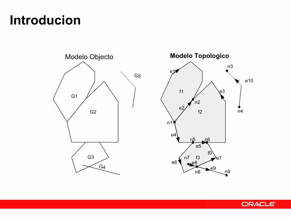
Introducion
G1
G2
G3
G4
G5
f1
f2
f3f0
n1
n2
n3
n4
n5 n6
n7
n8 n9
e1
e2
e3
e4
e5
e6e7
e8e9
e10
Modelo Objecto Modelo Topologico
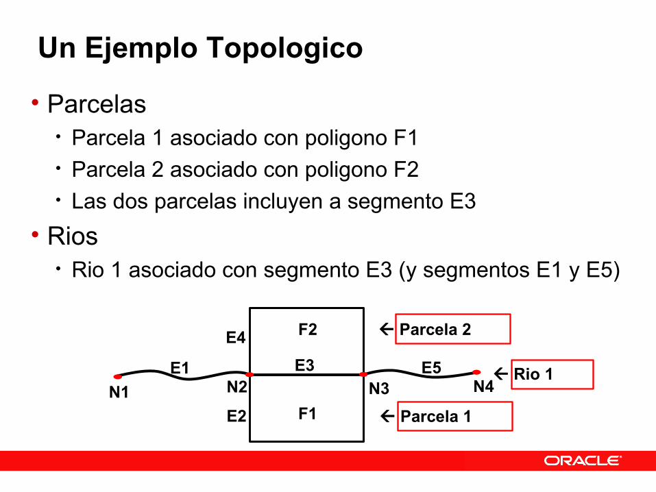
Un Ejemplo Topologico
• Parcelas• Parcela 1 asociado con poligono F1 • Parcela 2 asociado con poligono F2• Las dos parcelas incluyen a segmento E3
• Rios• Rio 1 asociado con segmento E3 (y segmentos E1 y E5)
N1E5
N4N3N2E1
E4E3
E2
F2
F1
Parcela 2
Parcela 1
Rio 1

Oracle SpatialNetwork Data Model
(Modelo de Red)
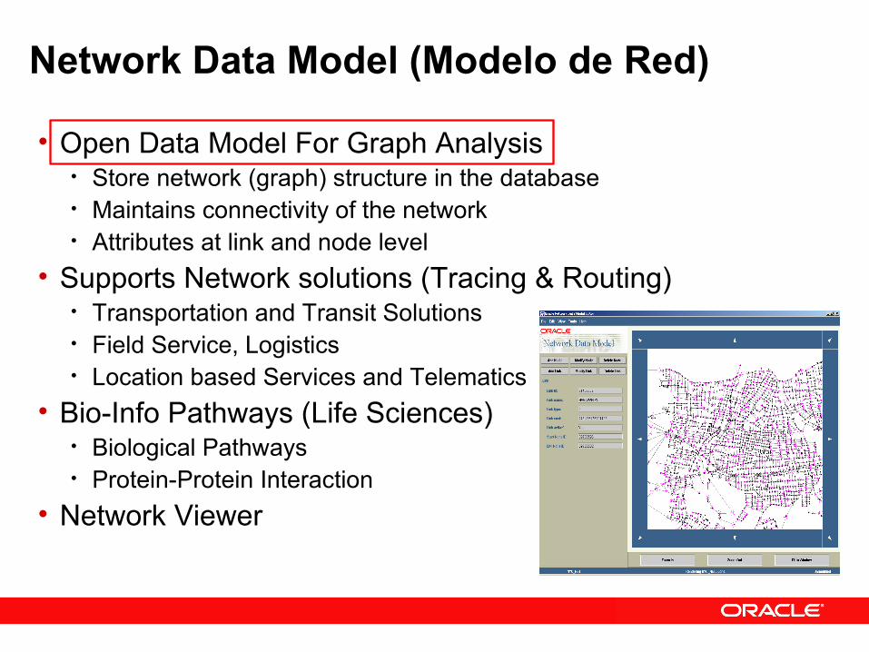
Network Data Model (Modelo de Red)
• Open Data Model For Graph Analysis• Store network (graph) structure in the database• Maintains connectivity of the network• Attributes at link and node level
• Supports Network solutions (Tracing & Routing)• Transportation and Transit Solutions• Field Service, Logistics• Location based Services and Telematics
• Bio-Info Pathways (Life Sciences)• Biological Pathways• Protein-Protein Interaction
• Network Viewer
Oracle Spatial 10gSpatial Analysis and Mining
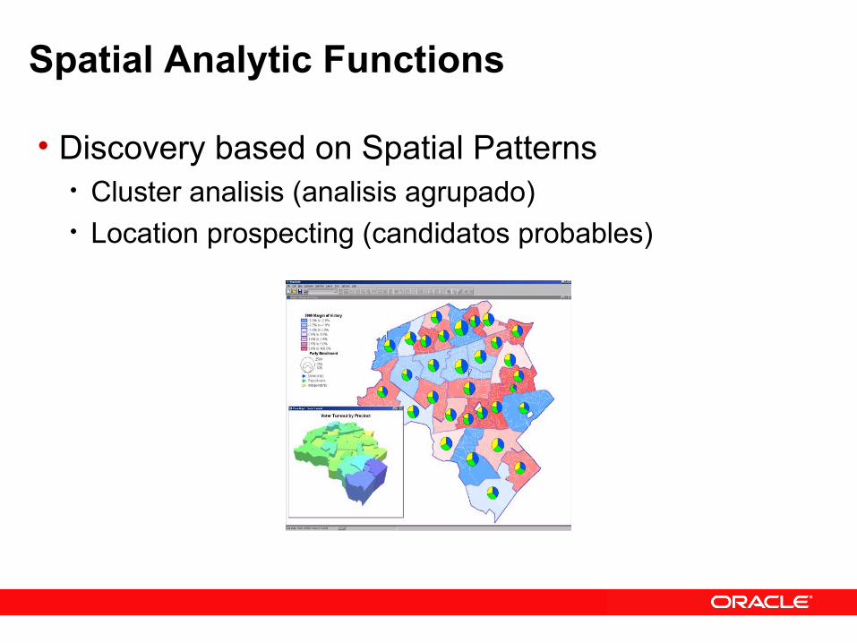
Spatial Analytic Functions
• Discovery based on Spatial Patterns • Cluster analisis (analisis agrupado)• Location prospecting (candidatos probables)

SDO_SAM.AGGREGATES_FOR_GEOMETRY: Example
SELECT SDO_SAM.AGGREGATES_FOR_GEOMETRY( 'GEOD_COUNTIES', 'GEOM', 'sum', 'totpop', SDO_GEOMETRY(2001, 8307, SDO_POINT_TYPE(-73.943849, 40.6698,NULL), NULL, NULL), 'distance=3 unit=mile')FROM DUAL;-----------------------723570.362
% COUNTY COVERED COUNTY ST TOTPOP BY WINDOW--------- -- ------ ----------Queens NY 1951598 00.5437756Kings NY 2300664 31.0430579New York NY 1487536 00.0188785
Queens
Kings
New York(-73.943849, 40.6698)

Standards Are Important SQL/MM Methods and OGC Standards
• GET_WKB() – Get Well Known Text• GET_WKT() – Get Well Known Binary set long 500; SELECT A.GEOM.GET_WKT() FROM polygon_table a WHERE id = 1;
A.GEOM.GET_WKT() ---------------- POLYGON ((146.0 66.0, 148.0 66.0, 148.0 68.0, 146.0 68.0, 146.0 66.0))

Fully exploit and support Standards-based, IT Architecture
• Scalability - large data volume• Availability – tens of thousands of users• Security – protect sensitive location data• Performance – timely query response• Accessibility – to enterprise applications• Manageability – leverage IT resources

Local Partitioned Spatial Indexes
• Major benefits are performance and manageability of very large data sets
• EXCHANGE PARTITION INCLUDING INDEXES supported for spatial indexes too
Customer example:
• Requirement:• Ingest and maintain 2 days of weather data online• 270,000 samples every 30 seconds
• Implemented with:• 30 second partitions (5760 partitions over 2 days)• New partitions rolled on, older partitions rolled off
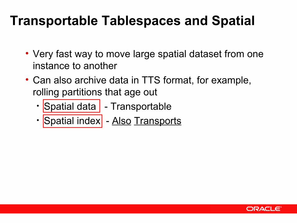
Transportable Tablespaces and Spatial
• Very fast way to move large spatial dataset from one instance to another
• Can also archive data in TTS format, for example, rolling partitions that age out• Spatial data - Transportable• Spatial index - Also Transports

Oracle Application Server MapViewer

Oracle Application Server 10.1.3 SOA MapViewer• Web Map Server (genera mapas para el web)
• Viene incluido en el Oracle Application Server. No tiene costo adicional.
• Integrado con Oracle Spatial y Oracle Locator• Es una manera facil para publicar mapas generados con el
dato espacial almacenado en el tipo de dato nativo espacial de Oracle
• API:• XML API• Java API• JSP Tag library• OGC WMS• API AJAX en la version MapViewer 10.1.3 SOA
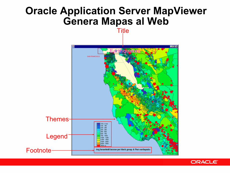
Oracle Application Server MapViewerGenera Mapas al Web
Footnote
Legend
Themes
Earthquakes
Title
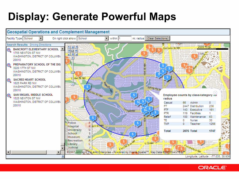
Display: Generate Powerful Maps

MapViewer with JDeveloper and Oracle BI Enterprise Edition
Oracle JDeveloper
Oracle BI EE

Oracle Application Server Version 10.1.3 SOA
Mapbuilder and MapViewer

MapBuilder 10.1.3 SOA
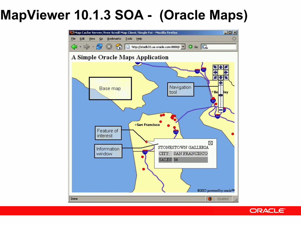
MapViewer 10.1.3 SOA - (Oracle Maps)

Oracle Locator – Sin Costo Adicional
• All Vector Data Types• Spatial Operators
• Topological• Distance
• Distance Function• SDO_UTIL package• Coordinate Transformations• Long Transactions• Table Partitioning*• Object Replication*• Oracle Label Security
Oracle Locator
Viene incluido sin costo adicional con:
• Oracle XE• Oracle Standard Edition• Oracle Standard Edition One• Oracle Enterprise Edition

Oracle Spatial
• All Locator features• GeoRaster Data Type• Topology Data Type• Network Data Model• Geocoding• Routing• Linear Referencing• Spatial functions
• aggregates• centroid, union, intersection, etc
• 3D Data type• LIDAR and TIN Data Types
• WFS-T, CSW (Web Services)
• Oracle Enterprise Edition • Lisenced Option
Aplicaciones Espaciales No Siempre Necesitan un GIS• Toda organizacion quiere reducir costos• La Tecnologia Espacial de Oracle contiene:
• Oracle Locator– Oracle Standard Edition– Oracle Enterprise Edition
• Oracle Application Server MapViewer– Java Edition– Standard Edition– Enterprise Edition
• Utilize lo que ya tiene

Oracle 11g Spatialfeatures

3D Data Management Oracle Spatial 11g

3-D Spatial Types
• 3D Types for points/lines/polygons/solids• Specialized types for large volumes of 3D point data
• POINT CLOUD - Represent scenes as a set of 3-d points obtained using laser scanners etc.
• TIN – triangulated surface representation • 3D Coordinate Systems • Address growing number of 3-d applications
• GIS, CAD/CAM• VR, Medical Applications• City Modeling
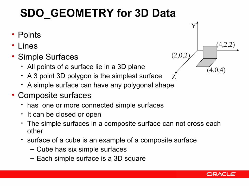
SDO_GEOMETRY for 3D Data
• Points• Lines• Simple Surfaces
• All points of a surface lie in a 3D plane• A 3 point 3D polygon is the simplest surface• A simple surface can have any polygonal shape
• Composite surfaces• has one or more connected simple surfaces• It can be closed or open• The simple surfaces in a composite surface can not cross each
other• surface of a cube is an example of a composite surface
– Cube has six simple surfaces– Each simple surface is a 3D square
(2,0,2)(4,2,2)
(4,0,4)
Y
Z
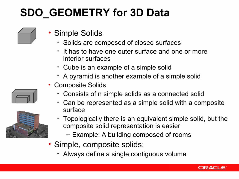
SDO_GEOMETRY for 3D Data
• Simple Solids • Solids are composed of closed surfaces• It has to have one outer surface and one or more
interior surfaces• Cube is an example of a simple solid• A pyramid is another example of a simple solid
• Composite Solids• Consists of n simple solids as a connected solid• Can be represented as a simple solid with a composite
surface• Topologically there is an equivalent simple solid, but the
composite solid representation is easier – Example: A building composed of rooms
• Simple, composite solids: • Always define a single contiguous volume
SDO_GEOMETRY for 3-D Data
• Support for multi-points, multi-lines, multi-surfaces, multi-solids• Multi-solid is different from composite solid
• Follows GML3, ISO 19107 Specifications• Export and Import support for CityGML
Some 3D SDO_GEOMETRY operations
• Spatial Indexing: R-trees• SQL Spatial Operator support
• SDO_FILTER, SDO_ANYINTERACT, SDO_WITHIN_DISTANCE, SDO_NN
• PL/SQL Functions• VALIDATE_GEOMETRY• SDO_DISTANCE, SDO_GEOM.ANYINTERACT• SDO_AREA, SDO_LENGTH, SDO_VOLUME• SDO_CS.TRANSFORM (e.g. to/from CityGML)

Specialized Types for High Density 3D Point Data
• Large volumes of point data acquired by sensors• LIDAR• Sensors used to collect data inside buildings
• Millions of points used to model a scene• SDO_GEOMETRY is not suitable for such data• POINT CLOUD data type introduced to efficiently
manage this type of point data• TIN to create triangulation of such points
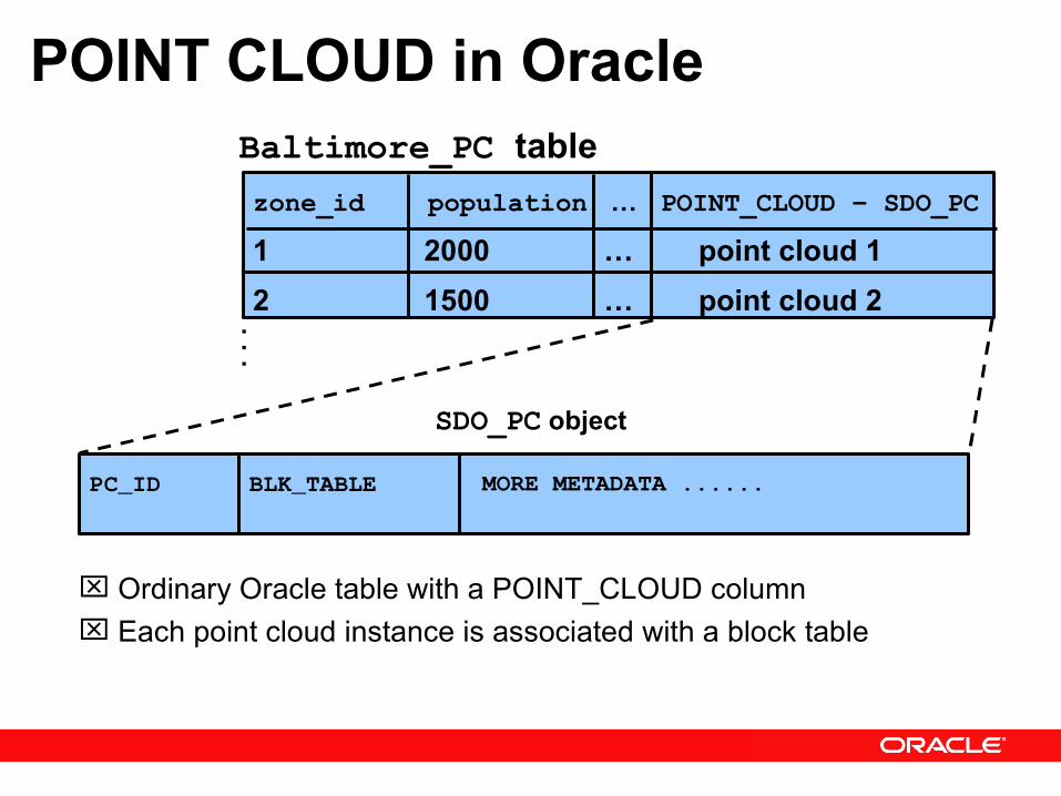
POINT CLOUD in Oracle
Ordinary Oracle table with a POINT_CLOUD column Each point cloud instance is associated with a block table
...
SDO_PC object
PC_ID MORE METADATA ......BLK_TABLE
zone_id population … POINT_CLOUD – SDO_PC 1 2000 … point cloud 1 2 1500 … point cloud 2
Baltimore_PC table

Table Column:POINT_CLOUD
Pts:LOB
PC_BLK_EXTENT: SDO_GEOMETRY
BlkidObjidTABLE of SDO_PC_BLK type
OTHERATTRS…
Each Point Cloud is Blocked
Point cloud partitioned into multiple blocks for granularity of access Each block is uniquely identified by Objid and Blkid Each point in the lob can have attributes stored in an optional table
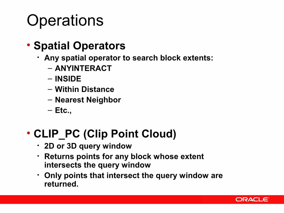
Operations• Spatial Operators
• Any spatial operator to search block extents:– ANYINTERACT– INSIDE– Within Distance– Nearest Neighbor– Etc.,
• CLIP_PC (Clip Point Cloud)• 2D or 3D query window• Returns points for any block whose extent
intersects the query window• Only points that intersect the query window are
returned.
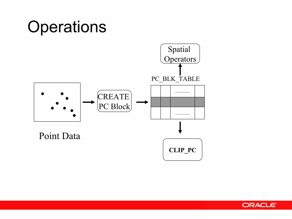
CREATE PC Block
CLIP_PC
Point Data
PC_BLK_TABLE
Spatial Operators
Operations

TIN: Triangulated Irregular Network• Definition
• Vector-based topological data model used to represent terrain/surface• Contain a network of irregularly spaced triangles • 3D surface representation derived from irregularly spaced points• Each sample point has an x, y coordinate and a z value or surface value
8177
2226
3565
4444
6513
5632
3651
ZYXNode No
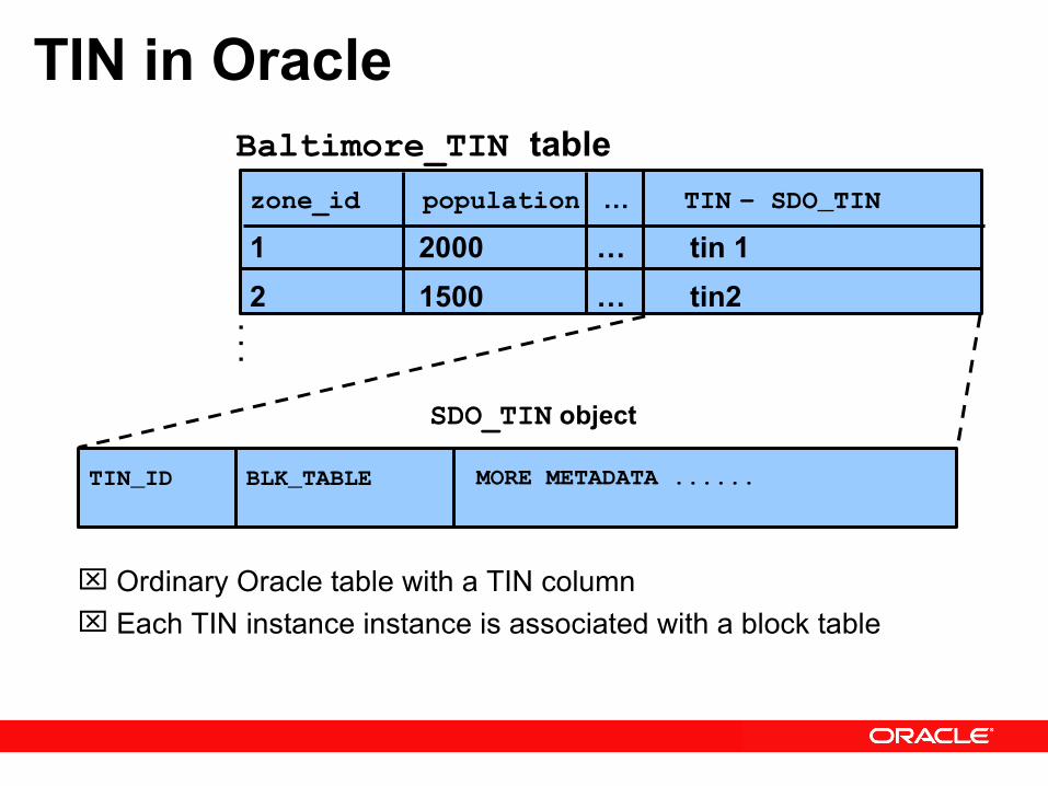
TIN in Oracle
Ordinary Oracle table with a TIN column Each TIN instance instance is associated with a block table
...
SDO_TIN object
TIN_ID MORE METADATA ......BLK_TABLE
zone_id population … TIN - SDO_TIN 1 2000 … tin 1 2 1500 … tin2
Baltimore_TIN table

Table Column:TIN
Triangles:LOB
TIN_BLK_EXTENT: SDO_GEOMETRY
BlkidObjidTABLE of SDO_TIN_BLK type
OTHERATTRS…
Each TIN is Blocked
TIN partitioned into multiple blocks for granularity of access Each block is uniquely identified by Objid and Blkid Each block has a LOB with all the triangles for that block Each point in the LOB can have attributes stored in an optional table

Operations• Spatial Operators
• Any spatial operator to search block extents:– ANYINTERACT– INSIDE– Within Distance– Nearest Neighbor– Etc.,
• CLIP_TIN (Clip TIN)• 2D or 3D query window• Returns points for any block whose extent
intersects the query window• Only triangles that intersect the query window are
returned.
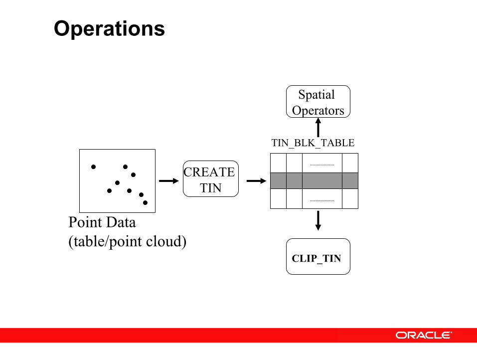
CREATE TIN
CLIP_TIN
Point Data(table/point cloud)
TIN_BLK_TABLE
Spatial Operators
Operations
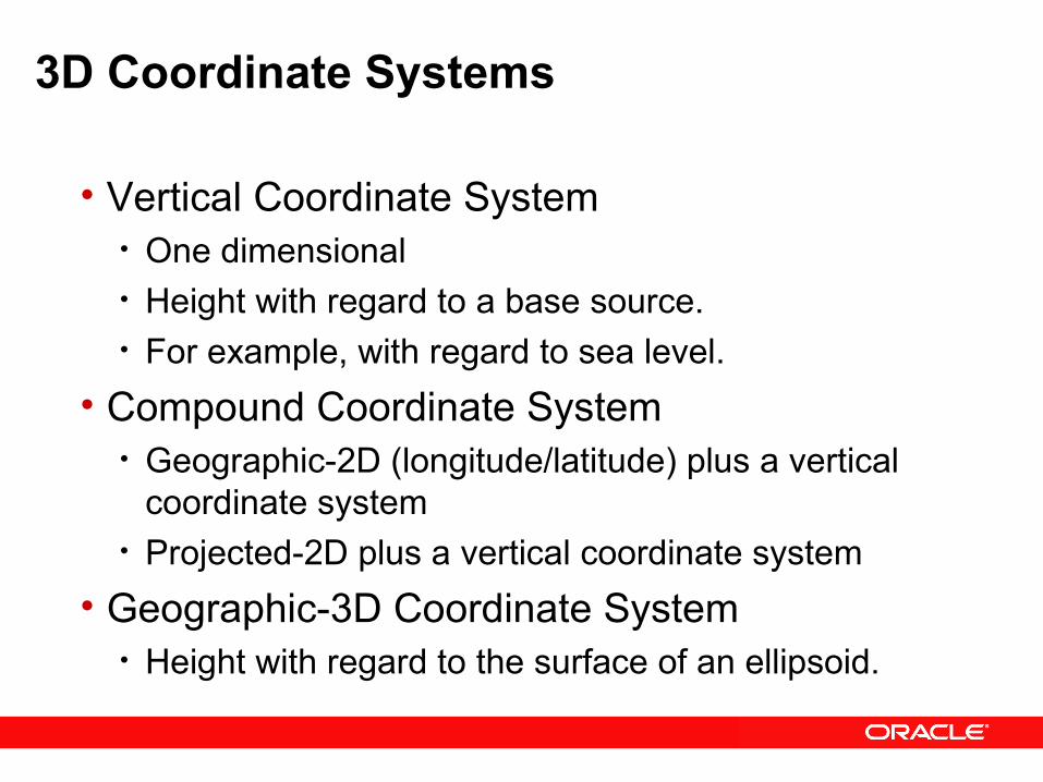
3D Coordinate Systems
• Vertical Coordinate System• One dimensional• Height with regard to a base source.• For example, with regard to sea level.
• Compound Coordinate System• Geographic-2D (longitude/latitude) plus a vertical
coordinate system• Projected-2D plus a vertical coordinate system
• Geographic-3D Coordinate System• Height with regard to the surface of an ellipsoid.

Spatial Feature – Web Services
• WFS 1.0 - Transactional• CSW 2.0 – Catalog Service Web
Mas Recursos...
Examples, white papers, downloads, discussion forum, sample data, customer successes, partner information, more
http://www.oracle.com/technology/products/spatial/
http://www.oracle.com/technology/products/mapviewer/

Ejemplos On lineORACLE SPATIAL
www.dondequeda.com.co

P &Preguntas & Inquietudes