
Envío de Correcciones diferenciales de las Mediciones … · Trimble 5800 / Net R4 Móvil celular...
19
Ricardo V. Romero Chasipanta Escuela Politécnica del Ejército [email protected] Envío de Correcciones diferenciales de las Mediciones GNSS en tiempo real (NTRIP) a través de dispositivos móviles celulares. PRUEBAS DE INICIACIÓN Autores: Ricardo Romero Alfonso Tierra Christian Pilapanta Andrea Viteri César Leiva
Transcript of Envío de Correcciones diferenciales de las Mediciones … · Trimble 5800 / Net R4 Móvil celular...

© C
op
yright Sh
ow
eet.com
Free template
released by
Showeet.com Ricardo V. Romero Chasipanta
Escuela Politécnica del Ejército
Envío de Correcciones diferenciales de las Mediciones
GNSS en tiempo real (NTRIP) a través de dispositivos
móviles celulares.
PRUEBAS DE INICIACIÓN
Autores: Ricardo Romero Alfonso Tierra Christian Pilapanta Andrea Viteri César Leiva

© C
op
yright Sh
ow
eet.com
Free template
released by
Showeet.com
GENERALIDADES

© C
op
yright Sh
ow
eet.com
Free template
released by
Showeet.com
NETWORKED TRANSPORT OF RTCM VIA INTERNET PROTOCOL (NTRIP)
Difunde correcciones diferenciales
Usuarios fijos o móviles
Internet inalámbrico (GSM/GPRS)
Fig 1. Sistema NTRIP Fuente: NTRIP Documentation v1.0

© C
op
yright Sh
ow
eet.com
Free template
released by
Showeet.com
COMPONENTES DEL SISTEMA NTRIP
NTRIP Source
Novatel GNSS750
NTRIP Server / Caster
SOKKIA GSR 2700RSX
NTRIP Cliente/Usuario
MobileNTRIP (NOKIA)
Trimble 5800 / Net R4
Móvil celular (Movistar)

© C
op
yright Sh
ow
eet.com
Free template
released by
Showeet.com
ANTECEDENTES
© C
op
yright Sh
ow
eet.com
Free template
released by
Showeet.com
IMPLEMENTACIÓN TECNOLOGÍA NTRIP (2011)
• Comparación entre RTK y NTRIP (Figura 2)
– La pérdida de señal es más frecuente con RTK-UHF (inicialización)
– Con la tecnología NTRIP se mejora la obtención de soluciones fijas.
• Resultados
— Levantamientos catastrales (1:1000) hasta 70 Km y 5 segundos de medición
Ricardo V. Romero Chasipanta

© C
op
yright Sh
ow
eet.com
Free template
released by
Showeet.com
NTRIP VS RTK
Fig 2. Levantamiento catastral con NTRIP (derecha) y RTK (izquierda) Fuente: Alvarez C.,2011

© C
op
yright Sh
ow
eet.com
Free template
released by
Showeet.com
FINALIDAD DEL
PROYECTO

© C
op
yright Sh
ow
eet.com
Free template
released by
Showeet.com
OBJETIVOS
• Proveer el servicio NTRIP a usuarios GNSS para diferentes aplicaciones en tiempo real y de precisión.
– Configuración de la estación de monitoreo continuo.
– Determinación la compatibilidad de las conexiones inalámbricas en la transmisión de correcciones diferenciales con diferentes equipos.
– Pruebas de comprobación de distancias entre equipos topográficos y NTRIP.

© C
op
yright Sh
ow
eet.com
Free template
released by
Showeet.com
UBICACIÓN DEL PROYECTO

© C
op
yright Sh
ow
eet.com
Free template
released by
Showeet.com
CONFIGURACIÓN DE LA ESTACIÓN DE MONITOREO CONTINUO
HOST: 190.15.140.11
MOUNTPOINT: ESPE
FORMATO: RTCM
© C
op
yright Sh
ow
eet.com
Free template
released by
Showeet.com
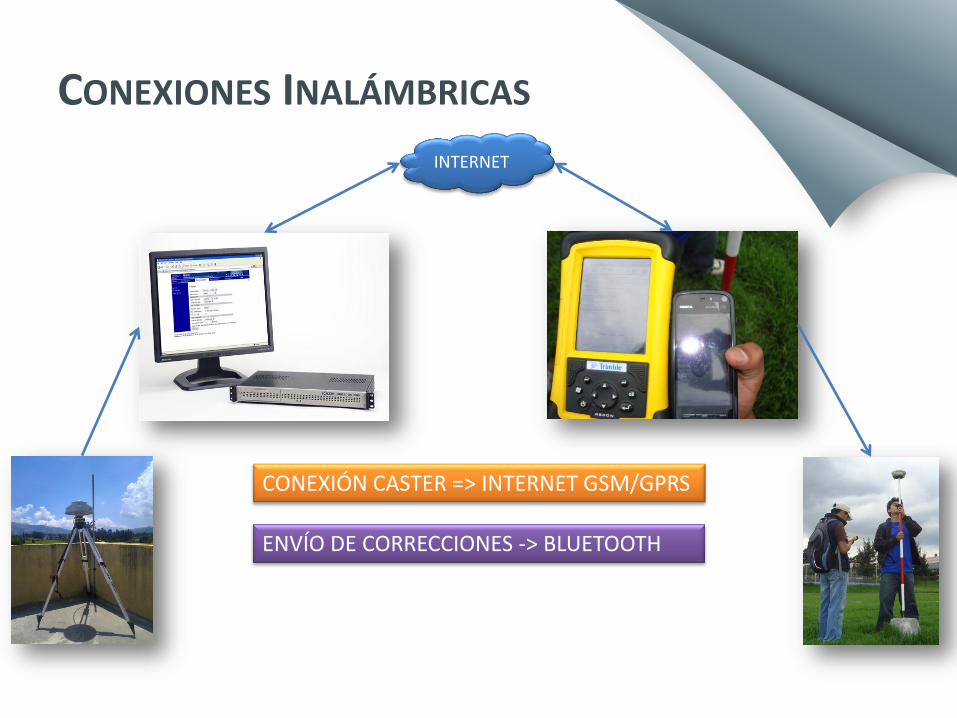
CONEXIONES INALÁMBRICAS
INTERNET
CONEXIÓN CASTER => INTERNET GSM/GPRS
ENVÍO DE CORRECCIONES -> BLUETOOTH

© C
op
yright Sh
ow
eet.com
Free template
released by
Showeet.com CONEXIÓN CON EL NTRIP CASTER
IP PUERTO USUARIO
CONTRASEÑA
MOUNTPOINT
RECIBE CORRECCIONES DESDE EL CASTER
PARÁMETROS DE CONEXIÓN

© C
op
yright Sh
ow
eet.com
Free template
released by
Showeet.com
ENVÍO DE CORRECCIONES VÍA BLUETOOTH 1 2
3 4 INICIO DEL LEVANTAMIENTO
Fig 3. Mediciones con NTRIP
# Mediciones = 1 Tiempo = 5 seg
© C
op
yright Sh
ow
eet.com
Free template
released by
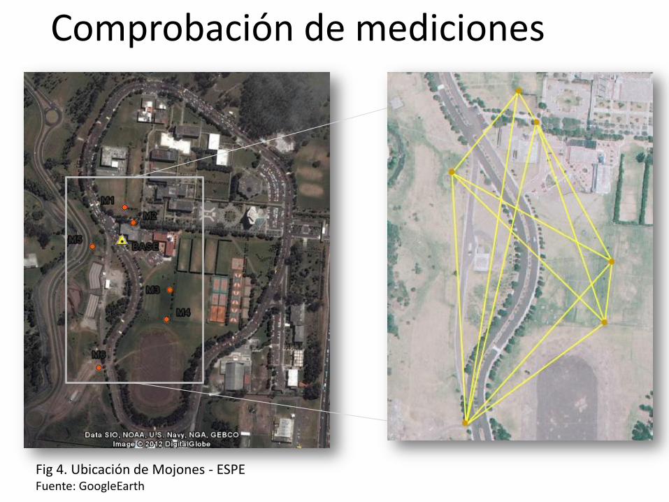
Showeet.com Comprobación de mediciones
Fig 4. Ubicación de Mojones - ESPE Fuente: GoogleEarth

© C
op
yright Sh
ow
eet.com
Free template
released by
Showeet.com
RESULTADOS

© C
op
yright Sh
ow
eet.com
Free template
released by
Showeet.com
NTRIP – ESTACIÓN TOTAL
DESDE HASTA DISTANCIAS (m) DIFERENCIA
(m) NTRIP ESTACIÓN TOTAL
M1 M2 39.889 39.944 -0.055
M1 M3 214.341 214.578 -0.237
M1 M4 271.938 272.107 -0.169
M1 M5 116.109 116.459 -0.350
M1 M6 369.736 369.014 0.722
M2 M3 174.454 174.641 -0.188
M2 M4 232.575 232.771 -0.196
M2 M5 108.200 109.041 -0.841
M2 M6 339.367 338.907 0.460
M3 M4 67.331 67.317 0.014
M3 M5 202.684 203.170 -0.486
M3 M6 240.481 239.826 0.655
M4 M5 236.528 236.850 -0.322
M4 M6 189.990 189.409 0.581
M5 M6 275.817 274.999 0.819
Error Promedio = 0,027 m Error mínimo = 0,013 m Error máximo = 0,841 m

© C
op
yright Sh
ow
eet.com
Free template
released by
Showeet.com
CONCLUSIONES
• Los usuarios GNSS pueden aplicar esta tecnología para levantamientos o mediciones que requieran niveles de precisión acorde con escalas de mayor detalle.
• Las conexiones inalámbricas en el sistema NTRIP dependen de la compatibilidad entre el receptor GNSS y el dispositivo móvil (bluetooth) y del acceso al NTRIP caster (internet móvil).