Lake Basin Management Initiative Experience and … Juan del Norte Port in the Caribbean, through...
29
Lake Basin Management Initiative Experience and Lessons Learned Brief Lake Cocibolca/Nicaragua Salvador Montenegro-Guillén* Centro para la Investigación en Recursos Acuáticos de Nicaragua (CIRA/UNAN) 1. Introduction Lake Cocibolca/Nicaragua is the largest freshwater lake in Central America and one of the largest in the Americas. The history of Nicaragua and Central America has developed linked to the inter- ests of conquerors and foreigners who sought to grasp the geopolitical assets of the Nicaraguan freshwater inland sea and its connection to the Caribbean through the San Juan River. This mag- nificent lake occupies the middle section of the tectonic valley shared with two other watersheds: Lake Xolotlán at upper, Lake Cocibolca and the San Juan River. This area forms the largest in- ternational drainage basin in Central America, with a total area of 41 600 km 2 , of which 70% or 29,000 km 2 are in Nicaraguan territory and 12,600 or 30% on Costa Rica. Background The Country Nicaragua is located at geographic coordinates: 13 00 N, 85 00 W (Center of the country), and is at the center of Central American countries. Figure 1 shows the geographic location of Nicaragua in the Americas. The Pacific Coast of Nicaragua was settled as a Spanish colony in the early 16th centu- ry. Independence from Spain was declared in 1821 and the country became an indepen- dent republic in 1838. Britain occupied the Caribbean Coast in the first half of the 19th century, but gradually ceded control of the region in subsequent decades. Governments were formed with people of the higher classes This paper was presented at the Lake Basin Management Initiative Regional Workshop for Europe, Central Asia and the Americas held at Saint Michaelʼs College in Vermont, USA, 18-21 June 2003. The workshop was organized by LakeNet in cooperation with SMC and the International Lake Environment Committee with funding from the Global Environment Facility, U.S. Agency for International Development, Shiga Prefecture Government and World Bank. The views expressed are those of the authors and not necessarily those of the project sponsors. * Corresponding author: [email protected]
Transcript of Lake Basin Management Initiative Experience and … Juan del Norte Port in the Caribbean, through...

Lake Basin Management InitiativeExperience and Lessons Learned Brief
Lake Cocibolca/Nicaragua
Salvador Montenegro-Guillén*Centro para la Investigación en Recursos Acuáticos de Nicaragua (CIRA/UNAN)
1. IntroductionLake Cocibolca/Nicaragua is the largest freshwater lake in Central America and one of the largest in the Americas. The history of Nicaragua and Central America has developed linked to the inter-ests of conquerors and foreigners who sought to grasp the geopolitical assets of the Nicaraguan freshwater inland sea and its connection to the Caribbean through the San Juan River. This mag-nificent lake occupies the middle section of the tectonic valley shared with two other watersheds: Lake Xolotlán at upper, Lake Cocibolca and the San Juan River. This area forms the largest in-ternational drainage basin in Central America, with a total area of 41 600 km2, of which 70% or 29,000 km 2 are in Nicaraguan territory and 12,600 or 30% on Costa Rica.
Background
The Country
Nicaragua is located at geographic coordinates: 13 00 N, 85 00 W (Center of the country), and is at the center of Central American countries. Figure 1 shows the geographic location of Nicaragua in the Americas.
The Pacific Coast of Nicaragua was settled as a Spanish colony in the early 16th centu-ry. Independence from Spain was declared in 1821 and the country became an indepen-dent republic in 1838. Britain occupied the Caribbean Coast in the first half of the 19th century, but gradually ceded control of the region in subsequent decades. Governments were formed with people of the higher classes
This paper was presented at the Lake Basin Management Initiative Regional Workshop for Europe, Central Asia and the Americas held at Saint Michaelʼs College in Vermont, USA, 18-21 June 2003. The workshop was organized by LakeNet in cooperation with SMC and the International Lake Environment Committee with funding from the Global Environment Facility, U.S. Agency for International Development, Shiga Prefecture Government and World Bank. The views expressed are those of the authors and not necessarily those of the project sponsors.
* Corresponding author: [email protected]

2 Lake Basin Management Initiative
belonging to two opposite parties which successively acceded by force to power, weakening and impoverishing the country in a long struggle that lasted more than three centuries. As part of a war in 1850, and in connection with the interest of the Transit Company, which carried passengers from San Juan del Norte Port in the Caribbean, through San Juan River and Lake Cocibolca, to Port San Juan del Sur in the Pacific Ocean coast, during the California Gold Rush, a filibuster invaded Nicaragua, became President and destroyed the capital, Granada. After ousting him, a brief calm period arrived but later foreign interventions backed a military regime which governed from 1936 until 1979. Violent opposition to governmental manipulation and corruption spread to all classes by 1978 and resulted in a short-lived civil war that brought the Sandinista Liberation Front guer-rillas to power in 1979. Nicaraguan alleged sympathy to leftist rebels in El Salvador caused the US to sponsor anti-Sandinista contra guerrillas through much of the 1980s. Free elections in 1990, 1996, and again in 2001 saw the Sandinistas defeated. The country has slowly rebuilt its economy during the 1990s, but was hard hit by Hurricane Mitch in 1998.
Economy: is based on Natural resources: gold, silver, timber, fish, and agriculture, and money shipments from relatives abroad to their families remaining in the country.
Industries: Are based in food processing, chemicals, machinery and metal products, textiles, cloth-ing, petroleum refining and distribution, beverages, footwear, wood.
Industrial production growth rate: 4.4% (2000 est.)
Figure 1. Geographic position of Nicaragua
Lake Cocibolca/Nicaragua Experience Brief 3
Electricity - production: 2.233 billion kWh (2000)
Electricity - production by source: fossil fuel: 82%, hydroelectric: 9% other: 9% (2000)
Agriculture - products: coffee, bananas, sugarcane, cotton, rice, corn, tobacco, sesame, soy, beans; beef, veal, pork, poultry, dairy products
Exports: are mainly commodities: coffee, shrimp and lobster, cotton, tobacco, beef, sugar, ba-nanas; gold $609.5 million f.o.b. (2001 est.)
Imports: Are finished goods and commodities like machinery and equipment, petroleum products, consumer goods, $1.6 billion f.o.b. (2001 est.)
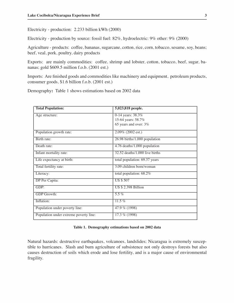
Demography: Table 1 shows estimations based on 2002 data
Total Population: 5,023,818 people.
Age structure: 0-14 years: 38.3% 15-64 years: 58.7% 65 years and over: 3%
Population growth rate: 2.09% (2002 est.)
Birth rate: 26.98 births/1,000 population
Death rate: 4.76 deaths/1,000 population
Infant mortality rate: 32.52 deaths/1,000 live births
Life expectancy at birth: total population: 69.37 years
Total fertility rate: 3.09 children born/woman
Literacy: total population: 68.2%
DP Per Capita: US $ 507
GDP: US $ 2.398 Billion
GDP Growth: 5.5 %
Inflation: 11.5 %
Population under poverty line: 47.9 % (1998)
Population under extreme poverty line: 17.3 % (1998)
Table 1. Demography estimations based on 2002 data
Natural hazards: destructive earthquakes, volcanoes, landslides; Nicaragua is extremely suscep-tible to hurricanes. Slash and burn agriculture of subsistence not only destroys forests but also causes destruction of soils which erode and lose fertility, and is a major cause of environmental fragility.

4 Lake Basin Management Initiative
The Watershed
Basic data of Lake Cocibolca (also known as Lake Nicaragua):
There are three subsystems or component basins in the catchment :
Lake Xolotlán or Managua watershed 6 669 km 2
Lake Nicaragua or Cocibolca watershed 23 844 km 2
San Juan River watershed 11 125 km 2
Of the 23 844 km 2 of the Lake Cocibolca basin, 19 693 km 2 (or 83%) are in Nicaragua and 4 151 km 2 (17%) are on Costa Rica.
Total surface: 8 000 km 2 at 31.40, meters above sea level.(Mean altitude)
Total water volume : approximately 104,000 hm3
Length of major axis: 160 km
Maximum Width: 70 km
Maximum Depth: There is no updated bathymetry of the lake. Nevertheless, with available data, max. depth is approximately 45 meters.
Mean Depth : approximately 13 m.
Catchment area : 15,844 km 2. Of these, 11,693 km 2 or 74% are on Nicaragua, and 4,151 km 2 or 26 % on Costa Rica.
Minimal historical altitude of water level: 29.57 m, in May 1886.
Maximum historical altitude of water level: 33.84 m, in November 1861.
Rainfall in the watershed: Varies from averages of 1 200mm per year in the northwest, at Malacatoya, to 4 000mm per year at Rio Frío upper watershed, southeast, in Costa Rica.
Water balance: (these are averages of 40 years of records)
Rainfall on the lakeʼs surface 401 m 3 / s
Rivers on the watershed 268 m 3 / s
Underground water 196 m 3 / s
Lake Xolotlán seepage outflow 5 m 3 / s
Total 870 m 3 / s
Evaporation from surface (calculated) 399 m 3 / s
Outflow (at San Carlos, through San Juan River) 476.6 m 3 / s
Lake Cocibolca/Nicaragua Experience Brief 5
There are thirty-two municipalities on the Nicaraguan side of the watershed, and ten on the Costarrican side. There are differences between both social and economic conditions of the two countries, which can be seen from the indicators shown in Tables 3 and 4 below.
For many years, transportation on the San Juan River and Lake Nicaragua has been an important factor in the socioeconomic and political development of Nicaragua. Interest in the construction of an inter-oceanic route tapping the potential of the San Juan River and Lake Nicaragua dates back to Spanish colonial times. The first historical data records that the San Juan River and Lake Nicaragua were used to transport the riches discovered on the western coasts of South America and shipped to Spain during the conquest of the continent. History shows that since 1504, Nicaragua has made over 10 attempts to construct an inter-oceanic canal. To date, however, none of the proj-ects have come to fruition. At present time (July, 2003), there are new attempts to organize a canal company (http://news.bbc.co.uk/hi/spanish/latin_america/newsid_3107000/3107937.stm).
With the discovery of gold in California (1848), transiting North Americans sought a faster route to the gold mines through the San Juan River and Lake Nicaragua. Reports from that time indicate that in 1853 some 20,800 traveled from the East Coast to the West Coast of the United States us-ing that route. Other data show that some 2,000 passengers were transported via that route on a monthly basis. However, an earthquake that occurred in July 1863 increased sedimentation in the San Juan River mouth, greatly increasing the difficulties of navigating that part of the river. Later, the construction of the transcontinental railway across the US in 1869 put an end to the great de-mand for passenger transport through Nicaragua.
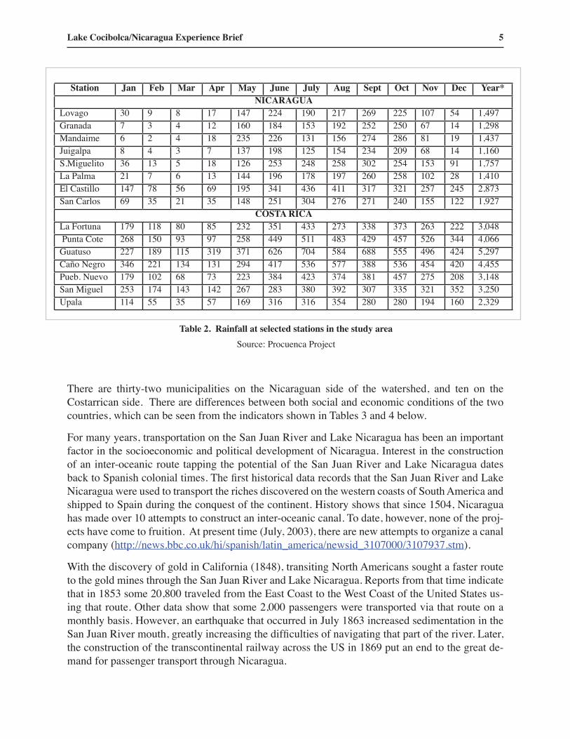
Station Jan Feb Mar Apr May June July Aug Sept Oct Nov Dec Year*NICARAGUA
Lovago 30 9 8 17 147 224 190 217 269 225 107 54 1,497Granada 7 3 4 12 160 184 153 192 252 250 67 14 1,298Mandaime 6 2 4 18 235 226 131 156 274 286 81 19 1,437Juigalpa 8 4 3 7 137 198 125 154 234 209 68 14 1,160S.Miguelito 36 13 5 18 126 253 248 258 302 254 153 91 1,757La Palma 21 7 6 13 144 196 178 197 260 258 102 28 1,410El Castillo 147 78 56 69 195 341 436 411 317 321 257 245 2,873San Carlos 69 35 21 35 148 251 304 276 271 240 155 122 1,927
COSTA RICALa Fortuna 179 118 80 85 232 351 433 273 338 373 263 222 3,048 Punta Cote 268 150 93 97 258 449 511 483 429 457 526 344 4,066Guatuso 227 189 115 319 371 626 704 584 688 555 496 424 5,297Caño Negro 346 221 134 131 294 417 536 577 388 536 454 420 4,455Pueb. Nuevo 179 102 68 73 223 384 423 374 381 457 275 208 3,148San Miguel 253 174 143 142 267 283 380 392 307 335 321 352 3,250Upala 114 55 35 57 169 316 316 354 280 280 194 160 2,329
Table 2. Rainfall at selected stations in the study areaSource: Procuenca Project

6 Lake Basin Management Initiative
Nevertheless, at the beginning of this century, interest in commercial navigation through Lake Nicaragua resumed. Of the studies conducted since the 1900s on the construction of an inter-oce-anic canal, the following are noteworthy:
• Isthmian Canal Commission, 1899-1901 • U.S. Army Corps of Engineers, 1929-1931 • Canal Study Commission, 1970 • Japanese Commission, 1989
Further projects related to the construction of an inter-oceanic canal have been presented more recently, using either the waters of the San Juan River and Lake Nicaragua or building a railway connecting the Caribbean Sea to the Pacific Ocean, or a combination of the two.
A number of boats that operate on Lake Nicaragua and in the San Juan River and its tributaries, facilitate the trading of goods with the Pacific region of the country and the transport of passengers to towns located in the western sector of the lake and in the Pacific zone. In some communities like North San Juan, existing water-based transportation routes between communities in Costa Rica is well known. Practically all the trade in between these communities takes place through Puerto Viejo in the Sarapiquí canton. Also, emergency medical attention and sometimes other basic ser-
Indicators Rivas Granada Masaya Boaco Chontales San Juan %School enrollment %
Preschool
Primary
Secondary
Technical
20.1
86.7
21.1
n.a.
25.1
87.3
18.9
1.3
28.1
99.6
38.8
0.05
10.85
73.7
16.6
0.2
10.9
61.6
16.4
0.5
16.8
76.0
7.0
0.4
18.2
80.4
25.0
0.7Health %
Malnutrition
Child health
Hospital beds per capita
27.8
603
n.a.
26.6
470
n.a.
31.8
887
n.a.
31.4
908
n.a.
23.2
687
n.a.
18.1
1.362
n.a.
26.0
710
Sewerage
Urban *
Rural *
41
86
20
64
41
85
53
69
--
77
1
17
31.2
66.3Pipe-borne water %
Urban
Rural
92
31
(1)103
44
92
59
92
25
75
35
64
15
86.3
34.8Housing
Housing per capita 5.7 5.8 5.7 5.9 6.3 5.9 5.9
Source: PROCUENCA SAN JUAN. Prepared on the basis of data from SILAIS, MINSA, INIFOM, and INECTable 3. Indicators of health and education on the Nicaraguan part of the basin

Lake Cocibolca/Nicaragua Experience Brief 7
vices, such as telephone communications with Nicaragua and education, are obtained through Costa Rica, along the waterways.
The main port facilities located in the SJRB are the following: San Juan del Norte, El Castillo, and Sábalos, located on the San Juan River; Granada, San Jorge, San Carlos, and San Miguelito, located on the banks of Lake Nicaragua; and Moyogalpa, Altagracia, and Solentiname, located on Ometepe Island and in the Solentiname Archipelago, respectively. Los Chiles, Puerto Viejo, and Barra Colorado are ports situated on the tributaries flowing from the southern sector of the basin. A feasibility study of the local transportation system in Lake Nicaragua and in the San Juan River conducted in 1970 found that the economic and financial benefit of the project was positive. Since then, however, there have been no new estimates on local navigation in these water bodies.
Navigation on the San Juan River and in Lake Nicaragua are affected by the progressive sedi-mentation of both water bodies. Navigation is also an important source of pollution of the water resources, due to the fact that boats are washed and serviced in both water bodies.
The waterbodies, therefore, become depositaries of hydrocarbon residue, agricultural chemicals, basic grains, pigs, domesticated animals, and other products that are transported across these bod-ies of water.
The basinʼs water resources have great potential for hydroelectric generation. The considerable flow rates, combined with significant altitude changes within the basin, have led to the develop-ment of this type of project in the SJRB. To date, there are four known hydroelectric development proposals to use the average flow rate at which Lake Nicaragua empties into the San Juan River as the source of the power supply. None of these options have been discarded as yet. The projects are: Tipitapa-Tamarindo, Brito, Brito Residual, and Interlagos.
Indicators (%) San Carlos
Guatuso Upala Los Chiles
Sarapiqui La Cruz Pococí Average
Illiteracy 10.20 16.00 18.30 19.40 12.80 20.00 10.90 15.37Birth rate 32.85 43.32 27.20 27.10 18.91 32.09 35.32 31.26Mortality (general) 3.62 2.86 2.74 2.18 1.45 3.41 3.49 3.33Infant mortality 12.75 8.61 17.8 22.18 11.00 18.52 10.51 14.48Neonatal mortality 8.93 11.56 4.01 n.a. 9.32 8.77 9.02 8.60Unemployment 4.70 5.00 5.70 4.10 4.50 7.70 8.70 5.77Population density 30.91 12.56 25.00 17.00 12.89 9.92 29.73 19.71Relative growth 55.50 52.10 43.40 27.20 48.30 63.40 43.00 47.55Primary sector 56.80 79.90 81.60 81.50 76.60 68.20 64.30 72.70Rural population 81.27 89.27 93.60 85.05 96.82 79.17 83.94 85.60Water supply – pipe-borne,* river, rain
83.0014.103.00
63.0034.003.00
56.0041.103.00
44.0053.402.00
48.0051.001.00
70.0010.1020.00
77.0016.306.00
71.0025.004.00
Sewerage, septic tanks, latrines,** bush
72.0028.000.30
38.4061.000.40
27.2073.000.20
28.7068.003.00
59.0041.000.00
31.0067.002.00
78.0022.000.10
61.0038.50.5
Housing per capita 4.9 5.3 6.4 8.13. 4.8 5.5 5.4 5.80
Source: PROCUENCA.
Table 4. Indicators of health and education on the Costa Rican part of the basin

8 Lake Basin Management Initiative
The construction of any of these projects will mean substantive changes in the average flow rate of the San Juan River, reducing it by some 36%. This will undoubtedly have a strong impact on navigation in the river. Aspects to be considered if these projects are implemented should be their effects on the aquatic life in the San Juan River and Lake Nicaragua, the flora and fauna existing in the area to be inundated by the proposed dams, and the environmental impact that will result from all the associated construction works.
In addition to the large projects discussed above, there are currently several public and private hydroelectric projects in the southern sector of the SJRB, which are at different stages of develop-ment. The private projects are approved by the ICE and carried out by private firms.
The possible conflicts in water use are discussed whenever an option for hydroelectric power or inter-oceanic canal construction is presented, especially since between 300 and 400 m³/sec of the existing river flows abstracted to meet the requirements for potable water and irrigation water sup-plying suitable farmland in the Pacific Region of Nicaragua.
On the banks of lakes Managua and Nicaragua and in the León-Chinandega plain, there are 742,000 hectares of land suitable for irrigation (152,000 ha in the Lake Managua zone, 432,000 ha in the area of Lake Nicaragua, and 158,000 distributed in the León-Chinandega area). The potential, available water in the León-Chinandega plain and along the banks of the lakes is approximately 745 millions cubic meters (MMC). This volume could provide the water supply to irrigate ap-proximately 138,000 ha, resulting in a shortfall in the amount needed to irrigate some 600,000 ha. To make up for this shortfall, a number of different alternative projects have been proposed, all of them drawing on Lake Nicaragua as the source. The most recent study, “Irrigation Strategy for Pacific Nicaragua”, envisaged damming the waters of the San Juan River at San Isidro, maintain-ing the water level of Lake Managua at 32 masl, draining water from Lake Nicaragua into Lake Managua by constructing a canal on the Tipitapa River, and pumping the water available up to the 100 masl mark. This scheme would then irrigate, using gravity, the 600,000 ha needing irrigation that are below this elevation. This project envisages generating power through the Tamarindo River, the replenishing of Lake Managua and the provision of drinking water supplies to towns requiring this service, including Managua.
Like the hydroelectric projects, this project will change the average flow rate of the San Juan River, which, in turn, will impact heavily on navigation of the river. Aspects to be considered with this project should be the effects on aquatic life related to the San Juan River, lakes Nicaragua and Managua, the existing flora and fauna in the area to be flooded by the proposed dam, and the en-vironmental impact of the construction and all related works. There is conflict in the use of water for this irrigation project because, the wider the area irrigated, the less water available for power generation and the drinking water supply.
Though the drinking water supply is a problem in the basin, it does not place any particular pressure on the resource because of the size of the demand. However, municipal and industrial wastewater does indeed pose a threat to water quality. Due to the fact that most of the population deposits its used water in riverbeds, streams, or directly in the lake or river with no prior treatment, the quality of the water of those bodies of water has noticeably deteriorated. Critical points are San Miguelito, San Jorge, Granada, Juigalpa, San Carlos, El Castillo, Sábalos and San Juan del Norte.
Lake Cocibolca/Nicaragua Experience Brief 9
Political – Administrative situation of the Basin
The area of the Lake Nicaragua - San Juan River basin system respects the physical boundaries of the watersheds of the hydrographic basin which do not coincide, in either of the two countries, with the political-administrative boundaries. This factor complicates the management of socio-economic information, usually available in accordance with the territory's political-administra-tive division. In Costa Rica, the political-administrative division is by provinces and “cantons” or municipalities; the Project of Formulation of a Strategic Action Program for the Integrated Management of Water Resources and the Sustainable Development of the San Juan River Basin its Coastal Zone (PROCUENCA, under auspices of OAS and PNUD), defines an area which com-pletely encompasses the cantons of La Cruz, Upala, Guatuso, Los Chiles, San Carlos, Sarapiquí, and Pococí; other cantons are partially within this area. However, due to the fact that they do not have a significant impact on the dynamics of the basin, they have not been considered in that study.
In the case of Nicaragua, the political-administrative division is defined in terms of departments and municipalities. The Nicaraguan sector includes the entire San Juan River Department and im-portant parts of the Departments of Masaya, Granada, Boaco, Chontales, and Rivas, with a total of 32 municipalities. PROCUENCA is at this moment the most important initiative to document the situation on the watershed to prepare a Management Plan.
PROCUENCA has calculated the population living within the projectʼs boundaries at 1,067,952. Said number is an approximate figure because the registers in both countries were defined on the basis of canton and municipality and not of the basin. The population belonging to the Nicaraguan sector is 779,339, or 73% of the basinʼs population; the population belonging to the Costa Rican sector is 288,613, representing the remaining 27%.
The geographic distribution of this population is not homogeneous. This is most notable in the case of Nicaragua, where 42% of the population is concentrated in four municipalities, and the most important cities (Masaya, Granada, and Juigalpa) are located within three of these. The remaining population is distributed over 29 municipalities. The average population density is approximately 46 inhabitants/km2. 55% of the population is rural.
In the Costa Rican sector, the population is predominantly rural (85% of the total). There is just one main urban center, Quesada City, capital of the San Carlos canton. The average density is 22 inhabitants/km2. These numbers can be misleading since there are extensive zones with very lim-ited populations, and parks, as well as reserves that are uninhabited.
Environment
The waters of the Lake Nicaragua-San Juan River watershed flow through at least eight distinct terrestrial ecosystems:
i) dry tropical forest to the east, north, and west of Lake Nicaragua; ii) cloud forest in the high areas of the Central Volcanic Cordillera of Costa
Rica;

10 Lake Basin Management Initiative
iii) moist tropical forest to the south and southwest of Lake Nicaragua and in the eastern foothills;
iv) very moist tropical forest in the San Juan Valley and on the coastal plains; v) gallery forest along river banks; vi) wetlands to the south of Lake Nicaragua and at the confluences of the
Colorado and Tortuguero rivers with the San Juan; vii) second-growth forest, meadows, and agricultural land in extensive areas of
the basin; and viii) coastal forest and mangrove swamps on the Caribbean coast. The Indio and
Maiz river basins are basically covered by moist and very moist tropical forest.
Figure 2 shows the Lake Cocibolca and San Juan River watershed, and the component tributary river basins.
Because of this range of ecosystems and associated habitats, the Lake Cocibolca – San Juan River watershed has a wealth of biodiversity. Its location in the natural biological corridor running the length of Central America has made it a meeting ground for species from the subarctic areas of North America and others from the subtropics of South America. To a great extent, its natural his-tory is unique. The low population density in a few parts of the Lake Cocibolca – San Juan River
Figure 2. Tributaries in Basin

Lake Cocibolca/Nicaragua Experience Brief 11
Watershed has kept it relatively pristine, although there is little information on the potential future impact of human migration trends and the spread of agriculture in the basin.
Regional studies now being carried out by the Central American Committee on Water Resources, with international cooperation, led to the conclusion that the fresh water in the Lake Cocibolca – San Juan River Watershed is the only source capable of meeting the foreseeable development needs of the semiarid Pacific slope of Central America, the regionʼs most populated area. Thus, it is likely that this system will come under increasing pressure of human exploitation. In addition, because the Lake Cocibolca – San Juan River Watershed is also a common westward passageway for anticyclones from the Atlantic to the Pacific, the threat of hurricanes and tropical storms, on top of the threats posed by volcanic activity and seismic pressures that already make this fresh water supply especially vulnerable, further exacerbates the human pressures likely to be experienced within this hydrologic system.
However, there are other threats to the Basin, coming from residues of pesticides and other ag-rochemical substances. In 1992, The Research Center for Inland Waters of Nicaragua, (CIRA/UNAN), affiliated to the National Autonomous University of Nicaragua, at request of the Ministry of Environment and Natural Resources (MARENA), carried out a sampling campaign on waters, benthic organisms and sediments of San Juan River. The results, showing high concentrations of pesticides used in banana plantations, were sent by MARENA Minister to the Chancellorʼs office and a verbal note of protest was presented by Nicaragua to the Costa Rican Government. Consequently, a meeting of the Central American Commission of Environment and Development (CCAD) requested support to OAS and PNUD to initiate a research program to establish the sever-ity of the problem.
In October of 1994, UNEP and GS/OAS signed an Agreement in which both organizations agreed to support Costa Rica and Nicaragua in carrying out the Project for Environmental Management and Sustainable Development of the San Juan River Basin. UNEP agreed that the OAS would be the executing organization with respect to technical cooperation. The project's technical activities were initiated in June of 1995.
The project's main objectives were defined as those relating to human development and the preser-vation of natural resources and ecosystems. The following aspects were given priority:
- Management and preservation of shared basins and water resources.- Management of protected areas and preservation of biodiversity.- Incentives for the development of sustainable economic activities.- Overcoming the populationʼs conditions of poverty, and attention to indigenous groups.- Institutional strengthening and legislation which would reconcile key issues at the border
and Central American level.
Due to their characteristics, the Central American border areas, and especially the Project areas, are key elements in the structuring of any alternative directed towards protecting the environment, combating poverty, and creating a favorable atmosphere for the countries' sustainable development.

12 Lake Basin Management Initiative
Likewise, the border areas favor the possibility of creating biological corridors which would permit the most effective preservation of biodiversity, avoiding fragmentation of the natural ecosystems.
2. State of the Lake and Basin EnvironmentThe Great Lakes - San Juan River Basin includes three well-differentiated sectors: the Lake Managua basin with 6,692 km2, the Lake Nicaragua basin with 23,848 km2, and the San Juan River basin itself with 10,937 km2. Since Lake Managua occasionally connects with Lake Nicaragua through the Tipitapa River, it has not been considered in PROCUENCA Project. However, the basins of the Indio and Maíz Rivers in Nicaragua and the Tortuguero River in Costa Rica have been included because they share environmental conditions similar to those of the lower San Juan River basin.
It is noted that 26% of the riverʼs flow is contributions from Lake Nicaragua; 6.5% is generated between San Carlos and El Castillo; and 67.5% between El Castillo and Sarapiquí.
Sediments in Lake Cocibolca and the San Juan River
Sediments originate in the upper and middle parts of the basins and are the result of strong rains, the fragility of many volcanic soils, the deforestation to which the area has been subjected, and agricultural/livestock development.
Lake Nicaragua is the depository for sediments carried by its tributaries. It also receives laminar runoff and drainage from subsurfaces which carry dissolved or swept along pesticides and fertil-izers used in the area. There is almost no knowledge about the volume of sediment arriving at Lake Nicaragua. This information is essential if we are to appreciate the seriousness of the problem and to implement the conservation practices, requirements that would allow for the preservation of lake.
At the Terrón station on the San Carlos River in Costa Rica, the contribution of sediment was cal-culated at 817 tons/Km²/year; at Peñas Blancas, 700 tons/Km²/year; at Punta Viejo and Veracruz on the Sarapiquí River, it was calculated at 216 tons/Km²/year. At the Guatuso station on the Frío River, a contribution of 298 tons/Km² year was calculated.
Station Jan Feb Mar Apr May June July Aug Sept Oct Nov Dec Year*
San Carlos 352 324 365 245 206 196 207 255 320 386 422 399 298
El Castillo 419 348 383 233 235 276 391 417 457 498 468 438 372
Sarapiquí 1,049 836 767 484 791 1,183 1,387 1,309 1,134 1,434 1,607 1,593 1,131
Table 5. Monthly flows of the San Juan River(modified from Diagnostic Study of the SJRB – OAS)

Lake Cocibolca/Nicaragua Experience Brief 13
In Nicaragua, agricultural activity and deforestation have caused erosion problems and, as a result, floods and the diversion of watercourses.
Periodic samples of sediments suspended transported by the rivers have not been taken at key stations, however the sedimentation can be verified visually. Already in 1868, Thomas Belt, an English mining engineer and naturalist, noted the sand banks development along the San Juan River due to deforestation. Sediment has caused some riverbeds to be filled in, with the conse-quent problems of overflow, floods, and the formation of new beds. This especially affects the San Juan River delta and, therefore, the animal habitat of the seacoast.
Presence of Pesticide residues in sediments of Lake Cocibolca
The agriculture on the basin relies on heavy usage of agrochemicals. Table 6 shows crops raised in both sides of the basin, and the different substances employed. Lack of control of both substances and concentrations applied remains as a major challenge to meet.
In 1994, 1997, 2002 and 2003, CIRA/UNAN has carried out sampling campaigns surveying organ-isms, (Fitoplancton, Zooplancton, Fish, Benthic organisms), water and sediments, and most strik-ing results are those of pesticide residues contents of the sediments. Organochlorine Pesticides, (pp-DDT, Lindane, Dieldrin, Heptaclore), and Organophosphorous (Methyl Parathion) were found in all 49 sampled sites, at concentrations of health concern both for people and the environment. Please see Appendix 1. Figures a, b, c, d and e.
Biological Diversity
The confluence of the bio-geographical regions of North and South America has given the San Juan River basin a varied and rich biological diversity. In addition, the largest tropical rain for-
CROPS Insecticides Nematicide Fungicide Anti- bacterial/
viral
Herbicide Molluskicide
Rice X X X X Beans X X X X X XCorn X X X Roots and Tubers X X X X X Orange X X X X Banana X X X X Coffee X X Pineapple X X X X Sugar Cane X X X Cotton X X Peanut X X X X X Vegetables X X X X
Table 6. Crops and Pesticides used in the watershed area.

14 Lake Basin Management Initiative
est north of the Amazon region is also found here. However, the basin area has been irreversibly changed, despite the fact that nature reserves are maintained and appropriate areas are identified to serve as buffer zones and for environmental restoration. Some of these areas have a very high representation of ecosystem types, which affords them a high potential for use in non-extractive activities. These activities could generate resources to partially finance their protection and devel-opment activities.
A total of 51 protected areas, varying in type and size, have been identified in the basin. Thirty-three of these have been established in Costa Rica and 18 in Nicaragua. The main types of pro-tected areas found in the basin are: biological reserves, national parks, wildlife refuges, protected areas, and nature reserves.
The main threats to the preservation of biodiversity of the basin have been identified as:
- Lumber exploitation and deforestation- Recurrent burning of pastureland- Mining activities- Damming or redirecting of surface waters- Unplanned colonization and ramshackle settlements- Contamination by agrochemicals and other products- Erosion and soil loss- Problems regarding land possession- Lack of a unified conceptual framework between the two countries with respect to the man-
agement of protected areas.
In conclusion, it should be pointed out that in both countries, alternatives for the preservation and sustainable management of biodiversity exist. The alternatives include:
i) defining buffer zones to temper the pressures on protected areas; ii) implementing biological corridors which aid the preservation of species of
fauna or for environmental restoration; and iii) fostering greater understanding and abilities with respect to preservation
of the protected areas. In all cases, these alternatives are subject to a clear definition of objectives and methodologies which will help prioritize consistent with the aspirations, motivations, and opportunities afforded to local societies.
3. Economic Activities in the Basin, Based on Natural ResourcesAt different times, the section of the basin belonging to each country was affected by strong growth in agricultural and livestock activities. These activities have generally expanded both in suitable areas and in areas where the capacity for use under current conditions is for forests. As a result,

Lake Cocibolca/Nicaragua Experience Brief 15
there has been indiscriminate deforestation. In the case of Costa Rica, the forests that existed in the low lands, lands with lesser slopes, and non-floodable lands in the basin have practically disap-peared; and in the case of Nicaragua, the remaining natural forests have deteriorated up to the very boundaries of the most significant biological reserves. The process has been generated by the de-structive use of forest resources and the advance of shifting agriculture and livestock production. For this reason, significant areas have been exposed to erosion generated by high-intensity tropical rains, with the loss of soil which is then reflected in increased levels of water turbidity.
Production technologies, which are in many cases inappropriate, and the intensive use of agro-chemicals on certain crops have impacted the quality of water resources, a factor that has barely been studied.
In the Nicaraguan sector, the agricultural frontier is expanding, in many cases on ground of low productive capacity. This constitutes one of the causes of deforestation and of the great pressure on protected natural areas. It is estimated that 8.5% of the Nicaraguan sector and 8% of the Costa Rican sector is occupied by primary and secondary forests.
In the case of Costa Rica, the productive incorporation of these territories has already occurred and the need for land is now directly pressuring the protected areas. In Nicaragua, the agricultural frontier is still rapidly expanding eastward, in a new drive, without having achieved its consolida-tion and is threatening the Great Indio-Maíz Biological Reserve. The causes of this process are found in a combination of factors: it is linked to subsistence agricultural production, inefficient use of natural resources, and migration to new lands. These lands lose their fertility and are abandoned after a few years, making way for pastures and stockbreeding; thus the elimination of the forest is consolidated. At different times, this process has been encouraged by means of national incentives for stockbreeding, based on direct or indirect subsidies. The indiscriminate extraction of lumber has been an additional factor in deforestation. The options for discouraging the destruction of the forest do not seem simple. They require the implementation of mechanisms which intensify and permanently settle agricultural production. This would require the adoption of new practices by the producers, as well as a change in their attitude with respect to the use of natural resources. Forest production requires, in its turn, new approaches which revert the extractive concept of for-est exploitation. In addition, it would require a change to a productive activity with longer cycles, one which offers economic conditions that would permit it to compete with other alternative lands uses.
The area for agricultural uses covers 60% of the territory. In Nicaragua, the basin produces 26% of the national bean crop, almost 21 % of the sorghum, and slightly more than 16% of the corn and sugar cane. In the Costa Rican sector, the basin produces 54% of the beans, 11% of the sugar cane, 6% of the corn and banana production, and 90% of the production of tubers and roots.
Agriculture in the Cocibolca – San Juan River watershed area reveals marked asymmetries with respect to the number of producers and available land areas. Commercial producers represent 11% of the total and occupy 55% of the land, and small and subsistence producers represent 88% and occupy 49% of the total area.
In the Nicaraguan and Costa Rican sectors of the basin, stockbreeding has a fundamental role because nearly 20% of the national herd is found in the project area. In Nicaragua, the breeds are

16 Lake Basin Management Initiative
generally dual purpose. In Costa Rica, on the other hand, there is a tendency toward specialization in accordance with the type of production, meat or milk. Management of stockbreeding activities should improve at the global level in order to increase production instead of increasing land areas devoted to this activity. Improvement of the herds is a priority, as are planning and management of the fodder base, development of mating services, and improvement of sanitation.
Some industries associated with the primary production activities are located in the area. There are a total of 70 sawmills in operation, 10 in the Nicaraguan sector and 60 in the Costa Rican. Under the heading of agroindustries, the following stand out: in Costa Rica, the presence of four banana companies located in Pococí Canton, one citrus fruit processing plant in Los Chiles, three sugar mills, a milk producers cooperative located in Quesada City, San Carlos Canton, and numerous coffee processing plants. In the Nicaraguan sector, the agro-industrial activities are associated with the sugar mills located in Rivas Department, one tomato processor in Nandaime Municipality, one palm oil extractor in El Castillo Municipality, and several coffee processing plants.
4. Framework of Legal and Institutional WorkBoth countries have made progress with respect to the definition of a legal framework which con-siders, both in a sectorial or integrated manner, the factors which create environmental manage-ment in national areas and in international relations. These instruments have two types of limita-tions: on the one hand, institutional and organizational capacity to implement them is weak, and on the other, there are gaps and overlapping areas which make it difficult to use them adequately. It is not by coincidence that in both countries, changes have occurred in the legal instruments which are conducive to improving the unity and coherence which reality demands. The creation of the Ministry of Energy, Resources, and Mines (MINAE) and the Ministry of Environment and Natural Resources (MARENA) as organizations responsible for environmental management and manage-ment of natural resources in Costa Rica and Nicaragua, respectively, are two examples. Also, in both countries there are numerous institutions which directly or indirectly have authority over the environment and various natural resources, including water, which makes it difficult to clearly es-tablish their jurisdictional boundaries, their responsibilities, and the control which each exercises in practice. This multiplicity of jurisdictions and superposition of functions caused by the various activities that are carried out both in and outside of the basin, impacts negatively on the evaluation and control of the environmental impacts.
In short, the existing constitutional mandates, institutional mandates, laws, and international agree-ments suggest that there is a sufficient regulatory framework to direct environmental management actions, biodiversity preservation, and sustainable development. The major limitations are associ-ated with the institutional, technical, and organizational capacity to enforce compliance with this regulatory framework and the lack of public awareness which facilitates legal action in every country. Although the instruments which regulate binational relations with respect to the bound-aries and the laws of the countries associated with the San Juan River do exist, the regulation of environmental issues where water resources are key, and the intent to jointly develop the territo-ries around the basin lack the legal framework that promotes binational cooperative efforts. The national initiatives have concentrated on a few agreements regarding specific work. For example, the Proyecto de Areas Protegidas para la Paz (Protected Areas for Peace Project, SI-A-PAZ) with

Lake Cocibolca/Nicaragua Experience Brief 17
regards to the efforts undertaken by the presidents and chancelleries of both countries, through which the Binational Commission has been, in recent years, revitalized to deal with border issues of common interest.
Constitutional Framework
Costa Rica and Nicaragua define their borders in accordance with the provisions of the Cañas:
• Jerez Treaty of April 15, 1858, ratified by the Cleveland Decision of March 22, 1888.• The State of Costa Rica, in its Constitution, Article 121, specifies that natural richness and
biodiversity, among others, are a benefit belonging to the nation; the same is stipulated by Article 89 with respect to natural beauty.
• The Constitution of Nicaragua refers specifically to the environment and natural resources in two articles: 60 Cn, which establishes the right of Nicaraguans to live in a healthy envi-ronment; and 102 Cn, which stipulates that natural resources are the national heritage.
5. Situation Assessment The GEF Operational Strategy lists four major areas of concern relating to international waters:
i) degradation of the quality of water resources; ii) physical habitat degradation of coastal and near-shore marine areas, lakes
and watercourses; iii) the introduction of exotic species that disrupt aquatic and land ecosystems
and iv) excessive and/or inappropriate exploitation of resources due to inadequate
management and control measures.
The analysis was carried out with the active participation of key stakeholders, and based upon an earlier study, carried out jointly by UNEP and the OAS, that pointed to a number of current and emerging problems that threaten the sustainability of development in the San Juan River Basin and ultimately the quality of life of the people who live there. These transboundary environmental problems often have common roots and manifest themselves both individually and collectively. They are closely interrelated, but in the interest of seeking solutions they have been broken down as follows:
The Accelerating Degradation of Transboundary Ecosystems
In the traditional uses of the main ecosystems of the area, human activities have exerted pressures on the environment and resulted in conflicts among the various groups involved, with negative consequences for the quality of water resources. These consequences include inadequate urban,

18 Lake Basin Management Initiative
industrial, and agroindustrial wastewater treatment systems; migratory agriculture, extensive graz-ing and the consequent extension of the agricultural frontier; widespread cutting of trees for tim-ber, unregulated ecotourism, non-conservationist farming practices, the introduction of aggressive exotic species such as Tilapia spp; and uncontrolled fires in the drier forests and of grassland. An emerging problem is the growing use of small and very small hydropower plants to tap the consid-erable hydroelectric potential of the region.
Overexploitation of Valuable Natural Resources
The problems here are related to poor land use, especially the farming of hillside areas and wet-lands, the construction of poorly designed roads, unregulated fishing, and excessive exploitation of valuable moist tropical forest species and the destruction of plant cover in fragile areas, causing erosion and land degradation. The result is a loss of potential income from agriculture, fishing and tourism, a threat to biodiversity and the natural productivity of the ecosystem, and a change in coastal and inland waterway dynamics. There are signs that three marine and freshwater species are being over exploited: Carcharhinus leucas, locally called “bull shark” or “freshwater shark” because of its unique behavior of migrating between the Caribbean Sea and Lake Nicaragua; Pristis perotteti or big sawfish; and Pristis pectinatus or fine- toothed sawfish.
Soil degradation and increasing sedimentation
Part of the sedimentation of the San Juan River and its coastal zone is produced as a result of natural processes, according to historic documents. Nevertheless, road construction, the advancing agricultural frontier, and hillside farming without adequate soil-conservation techniques exacer-bate sedimentation problems, as well the emerging problems arising from open-pit mining and the extraction of construction materials.
Pollution of Water Bodies
The main causes of water pollution are the indiscriminate use of pesticides and fertilizers, espe-cially where intensive farming practices are used, and urban, industrial, and agro-industrial waste discharges. The water bodies being affected in Nicaragua are Lake Nicaragua, the San Juan River and its coastal zone, the wetlands to the south of Lake Nicaragua. In Costa Rica the Caño Negro wetlands, the Colorado River, and the Tortuguero canals are suffering the consequences of degrad-ed water quality. Sporadic die-offs of aquatic fauna and flora give evidence of such degradation, as do small-scale and occasional studies of water quality that have been carried out in some parts of the Lake Cocibolca - San Juan River Basin.
High Vulnerability to Natural Hazards
This is apparent in the devastating impact of hurricanes and tropical storms on the regionʼs ill-housed populations, on its infrastructure, and on crops grown in areas where the forest has been cleared and the soil is fragile--areas exposed to landslides caused by hurricanes, tropical storms,

Lake Cocibolca/Nicaragua Experience Brief 19
and seismic or volcanic activity. Natural hazards can have a drastic -- and dramatic -- effect on the watercourses of the region.
Inadequate Planning and Management
Although MINAE and MARENA are both trying to promote integrated watershed management using the legal mechanisms provided within each country through their own environmental leg-islation, there is no watershed planning and administration capacity in place. There have been no mechanisms for coordinating management and control across the international border and, thus, no ongoing institutional approach to water resources management in the Cocibolca –San Juan River Basin. The lack of comprehensive up-to-date data on the Cocibolca –San Juan River Basin how it is structured, how it works, what its socioeconomic dynamics are, how information is managed at the local level–makes it impossible to proceed with the minimum certainty needed.
Weak Institutions
Although both countries have quite comprehensive legislation on environmental management and the sustainable use of natural resources that could be implemented locally, a paucity of financial and human resources on the local level and the poverty in which most of the population lives makes compliance difficult.
Insufficient Human and Institutional Capacity
Natural resource management is inefficient and it will not be possible to strengthen environmental command-and-control mechanisms without first creating local economic foundations and training people.
Limited Stakeholder Participation
There is currently limited participation by stakeholders in sustainable development due to central-ization of decision-making, which the governments are currently trying to change. This situation, added to reductions in the size of government, has hampered local action. This organization rec-ognizes the need to promote and strengthen civil society organizations, increase the participation of women, and involve more people in decision-making on the sustainable development of the Cocibolca –San Juan River Basin. The initial steps toward enhancing stakeholder participation have been already taken during the execution of the Block B program and through other actions of MINAE and MARENA. These steps now need to be reinforced and further developed through programs to educate people about sustainable development and adopting sustainable production practices and lifestyles within a comprehensive watershed management approach that does not yet exist.

20 Lake Basin Management Initiative
Extreme Poverty
Extreme poverty, combined with high population growth, low incomes and a subsistence economy, poor sanitation conditions, and a relative imbalance in employment and income-generating oppor-tunities between the two countries, characterizes the current level of economic development in the Cocibolca –San Juan River Basin. Uncontrolled migration exacerbates the situation, by exceeding the capacity of existing institutions to meet all the sanitation, health, and educational needs cre-ated. The economic conditions force the inhabitants to move to the mountainsides and practice slash-and-burn agriculture just to survive. These reactions contribute to the environmental deg-radation being experienced in the Lake Cocibolca - San Juan River Basin, but can be addressed, in part, through building institutional capacities and creating economic instruments, neither now existing, to address such problems.
6. Enabling EnvironmentThus far, the PROCUENCA Project has been the only entity which has devised a comprehensive initiative, including critical policy, legislative and institutional framework for long term basin management. It is comprised in the following components:
Component 1: Formulation of the Strategic Action Plan, SAP. Development of the SAP is the core task to be completed by the Technical Units in close consultation with UNEP and the GS/OAS pursuant to the implementation arrangements.
Component 2: Lake Cocibolca - San Juan River Basin information system. The objective of this Component is to enhance the capabilities of existing infrastructure in the decision-making process at all levels of government, and to encourage technical cooperation at the national level, by contributing and disseminating information among stakeholders, while, in the first instance, specifically facilitate data acquisition and sharing through an improved system.
Component 3: Strategic actions with stakeholder involvement. Strategic planning and manage-ment will depend on integrating basic research with a series of activities and investment projects carried out within the identified geographic and subject areas to be targeted for development. Historically, such projects have lacked effective stakeholder involvement as a result of the institu-tional and human resource issues identified above. As an integral part of the process of formulating the SAP for the Lake Cocibolca - San Juan River Basin, a series of demonstration activities illus-trative of ways and means for promoting sustainable agriculture production and the conservation restoration of land and water ecosystems will be conducted, providing both an assessment of cost and feasibility, and specific examples to local communities of alternative means of production and land and water resource management. Economic mechanisms contributing to the sustainable management of natural resources and to meeting the demand of the inhabitants for improved living conditions, and to solve the conflicts that can arise over plans and decisions affecting resource use will be specifically identified and developed. This component will facilitate interaction between the GEF-funded activities and those of on-going development projects.
Component 4: Public Participation. This component will foster and support the participation of all stakeholders, including the general public, in the development and implementation of the activ-

Lake Cocibolca/Nicaragua Experience Brief 21
ities carried out under the Lake Cocibolca - San Juan River Basin project, and complement the ac-tivities proposed under Component 3 (above). Success is dependent on identifying and motivating stakeholders and giving them an opportunity to participate, including, where necessary, through financial contributions. National and binational workshops will be organized to give stakehold-ers the opportunity to become involved, to engage their commitment and facilitate SAP imple-mentation. The project team will strive to assure gender balance in these activities. To establish a broad base of participation and learn the capacity of organizations to carry out actions, the four demonstration projects in various natural areas within the Lake Cocibolca - San Juan River Basin are envisioned. These activities are to be more broadly-based and inclusive of the general public and public-at-large than those to be conducted under Component 3 (above), and will contribute to inclusion of public inputs beyond those considered from an economic perspective.
Component 5: Local, national and bi-national level institutional arrangements. This compo-nent is designed to correct problems identified in the TDA regarding the shortcomings in institu-tions working at the local and national levels, and to encourage enhancement of binational coordi-nation between institutions within the Lake Cocibolca - San Juan River Basin as well as to ensure that the prescribed actions of the SAP are incorporated into national policies. Technical meetings bringing together MINAE and MARENA personnel and cooperative research efforts between uni-versities and other institutions of both countries will be promoted. Current institutional arrange-ments and the role they play in the management of the San Juan River Basin will be reviewed. This component is complementary to component 6.
Component 6: Capacity building and institutional strengthening. This component will foster the formation of basin councils in critical sub-basins and encourage the participation of such coun-cils within the municipal sustainable development councils existing within the Lake Cocibolca - San Juan River Basin. The Federation of Local Border Governments will be strengthened through specific activities with clearly defined goals in order to promote the strengthening and further development of coordination mechanisms at the local level. A proposal to strengthen institutions will be drafted with measures for: i) building sustainable development planning and management capacities; ii) improving infrastructure; iii) equipping institutions; and iv) designing mechanisms to increase the incomes of local and regional institutions. These activities will be supported by two demonstration projects establishing costs and feasibility of achieving integrated management as well as assessment of specific paradigms to be developed at specific sites within the Lake Cocibolca - San Juan River Basin .
Component 7: Education and training in conservation and the sustainable use of natural resources. This component has been designed to provide the building blocks of an education and training Program that will make the inhabitants of the Lake Cocibolca - San Juan River Basin more aware of the important role that water resources play in society, in the economy, and in na-ture. It will be especially geared to students and young people, who generally are more willing to change their habits and production practices, and who have been shown to be effective conduits by which such habits and practices can be transferred into individual households to the benefit of entire communities. Best sustainable production practices will be identified. The information will be disseminated in both countries and knowledge will be furthered through training for various kinds of local organizations working in the fields of development and environmental conservation. Workshops, seminars, and technical meetings will be held in conjunction with the preparation of

22 Lake Basin Management Initiative
the SAP. Materials for environmental education will be collected, designed, and implemented in three demonstration projects, which will be evaluated to aid in the design of the implementation Program.
Initiatives from Municipalities
Local governments, have a crucial role to play in the development of the afore-mentioned process-es. In parallel with the work carried out by PROCUENCA, the municipalities around Cocibolca organized in an Association of Municipalities of the Great Lake (AMUGRAN), which consists of 32 municipalities. Figure 3 presents the geographic distribution of these municipalities. The Association has agreed on a Declaration of Policies for Uses of the Lake Cocibolca and its basin, and on their Conservation. This historic declaration sets a reference framework so stakeholders on the municipalities are helping to define both the course of the economic development and the protection of the basin resources.
Figure 3. Municipalities on the Basin of Lake Cocibolca and San Juan River

Lake Cocibolca/Nicaragua Experience Brief 23
Risks and Sustainability
In order to formulate a SAP for the sustainable development of the Lake Cocibolca - San Juan River Basin by bringing the people of Costa Rica and Nicaragua together in a participatory and coordinated fashion, several assumptions with certain inherent risks have been made as described below.
Since there is no bilateral legal and institutional framework for the well-ordered management of the Lake Cocibolca - San Juan River Basin or for common administrative actions to be taken on its behalf, the governments of Costa Rica and Nicaragua have each studied this request for financing in accordance with their internal procedures and will each submit it to UNEP/GEF for consider-ation. This is the same procedure they followed previously in applying for and receiving GEF PDF Block B funds.
The governments have decided to use this project as an instrument of cooperation and mutual un-derstanding for the benefit of their natural ecosystems, the environment and sustainable develop-ment of both countries, of Central America, and of the international community as a whole. The just completed phase is testimony to this desire. Thus, while all issues related to jurisdictional concerns remain to be resolved outside of the context of this project, a satisfactory resolution is presupposed.
Further, it is assumed that work already done in the Lake Cocibolca - San Juan River Basin has led to the correct identification of problems. In this regard, the TDA is and will continue to be of great significance, and will have to be continually updated.
It has also been assumed that the governments, local organizations, and universities want to coop-erate and coordinate activities in the Lake Cocibolca - San Juan River Basin. Since these proposals were formulated with the widespread participation of all interested groups, including both national governments, it would seem that this assumption is grounded in reality. Nevertheless, a constant effort by the Technical Units will be necessary to assure coordination on the part of the institutions and organizations of both countries.
Another major assumption is that financing and other resources are available. If the previous as-sumptions regarding the attitude of the stakeholders, including both national governments, are valid, the assumptions regarding the real availability of financing and other resources become all the more well founded.
To a large extent, the success of the Lake Cocibolca - San Juan River Basin project will depend on the timetable, or more precisely, on the performance of each component at the right time. To assure that this is the case, each country will name a technical coordinator to work directly under the executing agency. Moreover, the SAP will be given great flexibility, as occurred in the prepara-tory stage.
The national governments have pledged their support to actions proposed for implementation with the incremental financial assistance of the GEF by allocating to this project important state and national financial resources. Further, it is believed that local level initiatives could form a model upon which country level initiatives can be built over time, hence the adoption of a “bottom-up” approach in most of the project activities. It is anticipated that these “bottom-up” approach with
24 Lake Basin Management Initiative
the active participation of key stakeholders will enhance the probability of integrating SAP find-ings into national policies. The risk, however, is that these local level initiatives will not be adopted at the country level and this is the principal risk facing identified for this project.
7. Lessons Learned and Recommended Initiatives For a long time, state agencies from the Central Government of Nicaragua have not been able to coordinate development efforts on the basin of the Great Lakes – San Juan River system. As a con-sequence, many of the undesirable effects already presented above have resulted in degradation of the basin and loss of resources and development opportunities. Information now available from a major effort done through PROCUENCA sheds light on how stakeholders involved in concep-tion and development of plans, programs, and projects can help to improve the general situation. Public awareness of the losses of environment assets seen as both economic and social opportuni-ties losses, leads public opinion into national attention.
Lack of reliable scientific data has been a major drawback and must be taken into account for any Strategic Action Plan to be devised.
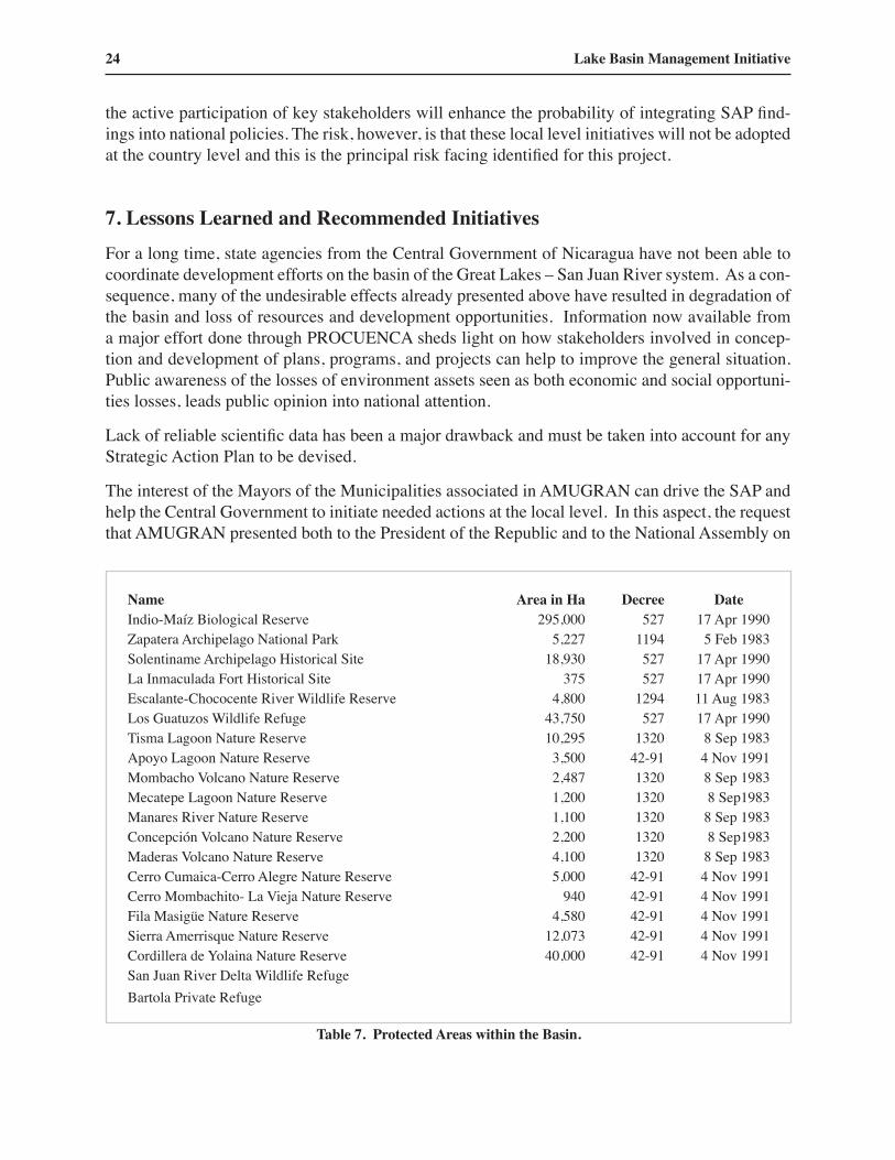
The interest of the Mayors of the Municipalities associated in AMUGRAN can drive the SAP and help the Central Government to initiate needed actions at the local level. In this aspect, the request that AMUGRAN presented both to the President of the Republic and to the National Assembly on
Name Area in Ha Decree Date Indio-Maíz Biological Reserve 295,000 527 17 Apr 1990Zapatera Archipelago National Park 5,227 1194 5 Feb 1983Solentiname Archipelago Historical Site 18,930 527 17 Apr 1990La Inmaculada Fort Historical Site 375 527 17 Apr 1990Escalante-Chococente River Wildlife Reserve 4,800 1294 11 Aug 1983Los Guatuzos Wildlife Refuge 43,750 527 17 Apr 1990Tisma Lagoon Nature Reserve 10,295 1320 8 Sep 1983Apoyo Lagoon Nature Reserve 3,500 42-91 4 Nov 1991Mombacho Volcano Nature Reserve 2,487 1320 8 Sep 1983Mecatepe Lagoon Nature Reserve 1,200 1320 8 Sep1983Manares River Nature Reserve 1,100 1320 8 Sep 1983Concepción Volcano Nature Reserve 2,200 1320 8 Sep1983Maderas Volcano Nature Reserve 4,100 1320 8 Sep 1983Cerro Cumaica-Cerro Alegre Nature Reserve 5,000 42-91 4 Nov 1991Cerro Mombachito- La Vieja Nature Reserve 940 42-91 4 Nov 1991Fila Masigüe Nature Reserve 4,580 42-91 4 Nov 1991Sierra Amerrisque Nature Reserve 12,073 42-91 4 Nov 1991Cordillera de Yolaina Nature Reserve 40,000 42-91 4 Nov 1991San Juan River Delta Wildlife Refuge Bartola Private Refuge
Table 7. Protected Areas within the Basin.

Lake Cocibolca/Nicaragua Experience Brief 25
June 4 and 5, 2003, to have a Law which would declare Corridor of Sustainable Development for the Municipalities contained in the Watershed of Great Lakes and San Juan River. This initiative would integrate the many protected areas, Ramsar sites, Archeological and cultural monuments, and would help the nomination of the Lake Cocibolca as aUNESCO world natural heritage site, requested by the Nicaraguan government. Table 7 shows the areas included in the basin.
8. ReferencesResearch Center for Inland Waters of Nicaragua (CIRA/UNAN) (1992- 2003) Excerpts from
published and unpublished data on Lake Cocibolca and San Juan River systems. Instituto Nicaraguense de Estudios Territoriales (Ineter) (1970 –2003) Metereological data.Diagnostic Study of the San Juan River Basin and Guidelines for an Action Plan (1997)
Organization of American States.Formulation of a Strategic Action Program for the Integrated Management of Water Resources
and the Sustainable Development of the San Juan River Basin and its Coastal Zone OAS / PNUD.http://www.oas.org
Logical Framework for Development of Strategic Action Programme (SAP) for the Integrated Management of the San Juan River Basin and its Coastal Zone (SJRB) OAS / PNUD. http://www.oas.org
Transboundary Diagnosis Analysis - Analysis of the cause-effect root chain of the major problems OAS / PNUD. http://www.oas.org
Transboundary Diagnosis Analysis - Tables: Main Crops and Agricultural Chemicals used in Project Area OAS / PNUD. http://www.oas.org
Executive summary Formulation of a Strategic Action Program for the Integrated Management of Water Resources and the Sustainable Development of the San Juan River Basin and its Coastal Zone OAS / PNUD. http://www.oas.org
Transboundary Diagnosis Analysis - Analysis of the Problems and their Root Causes OAS / PNUD. http://www.oas.org
Transboundary Diagnosis Analysis - Tables: Social Indicators for the Nicaraguan Segment of the Basin OAS / PNUD. http://www.oas.org
Transboundary Diagnosis Analysis - Tables: Protected Areas of Costa Rica in the San Juan River Basin OAS / PNUD. http://www.oas.org
Strategic Action Program – PROCUENCA San Juan OAS / PNUD. http://www.oas.org Transboundary Diagnosis Analysis - Tables: Social Indicators for the Costa Rican Segment of the
Basin OAS / PNUD. http://www.oas.org Transboundary Diagnosis Analysis - Tables: Physical Characteristics of Lake Nicaragua OAS /
PNUD. http://www.oas.org Transboundary Diagnosis Analysis - Tables: Estimate of the Polluting Potential of Human
Settlements OAS / PNUD. http://www.oas.org Belt, T. (1874) The Naturalist in Nicaragua. London, Murray.

26 Lake Basin Management Initiative
CIA - The World Factbook – Nicaragua: http://www.cia.gov/cia/publications/factbook/geos/nu.html USAID-Nicaragua Home Page: http://www.usaid.org.ni/

Lake Cocibolca/Nicaragua Experience Brief 27
Appendix 1
Figure a. Organochlorinated pesticide residues in Lake Cocibolca. 1994 Sampling stations 1 - 16
Figure b. Organochlorinated pesticide residues in Lake Cocibolca. 1994 Sampling stations 17 - 30

28 Lake Basin Management Initiative
Figure c. Organophosphorous pesticide residues in sediments. 1994.
Figure d. Organochlorinated pesticide residues in sediments, a) 1997.

Lake Cocibolca/Nicaragua Experience Brief 29
Figure e. Organo-chlorinated pesticide residues in sediments, (b, heptachlore) 1997