comunicacions totes final - Planeta...
71
Transcript of comunicacions totes final - Planeta...


XXXII Trobades científiques de la Mediterrània – Josep Miquel Vidal Planeta Oceà 1
Programa
Dimecres 5 d’Octubre
09:00‐10.00: Lliurament de la documentació
10.00‐10.25: Inauguració de les Trobades. Intervindran: Miquel Àngel Maria, Conseller de Cultura i Educació del Consell Insular de Menorca i president de l’Institut Menorquí d’Estudis; Josep Enric Llebot, president de la Societat Catalana de Física; Damià Gomis, en nom del comitè organitzador d’aquesta edició de les Trobades.
10.25‐10.30: Minut de silenci per Aida Fernández Ríos i Pablo Sangrà Inciarte
Modera la sessió: Dolors Blasco
10.30‐11.00: Ponència convidada de Marta Estrada: Patterns of phytoplankton distribution in stratified ocean waters
11.00‐11.15: Mikel Latasa, Renate Scharek, Xelu Morán, Mikhail Emelianov, Jordi Salat, Marta Estrada:
Dynamics of phytoplankton groups in the open NW Mediterranean
11.15‐11.30: Sdena Nunes, Mikel Latasa, Pep Gasol, Marta Estrada: Seasonal dynamics of the phytoplankton community in the Bay of Blanes, NW
Mediterranean Sea
11.30‐12.00: Pausa
Modera la sessió: Mikel Latasa
12.00‐12.15: Francesc Peters, Estela Romero, Rachele Gallisai, Òscar Guadayol: Seasonality of chlorophyll in the Mediterranean
12.15‐12.30: Maurizio Ribera d’Alcalà, Angela Falciatore: Light signals in the ocean: the case of phytoplankton photoreceptors
12.30‐12.45: Elisa Berdalet: Modulació de l’ecofisiologia del fitoplàncton marí per la turbulència de petita
escala: del laboratori al medi natural
12.45‐13.00: Miguel Cabrera, Celia Marrasé, Pedro Cermeño: Una aproximación experimental a la curva de remineralización de Martin: el
efecto de la composición taxonómica de las comunidades fitoplanctónicas en la exportación de carbono a los fondos oceánicos
13.00‐13.15: Beatriz Mouriño‐Carballido, Paloma Chouciño, Bieito Fernández, Miguel Gil Coto, Pedro Montero, Víctor Moreira‐Coello, Enrique Nogueira, Beatriz Reguera, Manuel Ruiz, Víctor Pelayo, Marina Villamaña:
Occurrence of thin layers of phytoplankton in the Galician Rías
13.15‐13.30: Francisco G. Figueiras, María Froján, Diana Zúñiga, Belén Arbones, Isabel G. Teixeira, Fernando Alonso‐Pérez, Carmen G. Castro:
Size‐structure of microbial plankton and mussels in the Rías Baixas

XXXII Trobades científiques de la Mediterrània – Josep Miquel Vidal Planeta Oceà 2
13.30‐15.00: Pausa
Modera la sessió: Elisa Berdalet
15.00‐15.30: Ponència convidada de Beatriz Reguera, Patricio Díaz, Lourdes Velo Suárez: Interacciones físico‐biológicas en poblaciones de fitoplancton nocivo en un sistema de afloramiento
15.30‐15.45: Magda Vila, Rafael Abós‐Herràndiz, Jordi Isern‐Fontanet, Laia Viure, Èlida Alechaga, Soraya Hernández‐Llamas, Pilar Campos, Encarnación Moyano, Josep Àlvarez, Elisa Berdalet:
Anàlisis de les proliferacions d’Ostreopsis cf. ovata associades a impactes sobre la salut humana a través d’una doble aproximació ecològica i epidemiológica
15.45‐16.00: Maria Montserrat Sala, Encarna Borrull, Mireia Mestre, Susana Sánchez‐del Río, Carolina Antequera, Eva Ortega‐Retuerta, Andrea Malits, Fran Aparicio‐Bernat, Pere Puig, Josep Maria Gasol, Hans‐Peter Grossart, Cèlia Marrasé:
Prokaryotic activity and diversity associated to particles in the NW Mediterranean
16.00‐16.15: Renate Scharek, Mikel Latasa: Vertical flux of organic and lithogenic matter off the north‐eastern and
northern coasts of the Spanish peninsula
16.15‐17.15: Sessió de pòsters / pausa
Modera la sessió: Francesc Peters
17.15‐17.30: Isabel Marín, Francesc Peters, Rachele Gallisai, Fran L Aparicio, Cèlia Marrasé, Riccardo Leardi, Xavier Querol:
Nutrient deposition in coastal waters of the northwestern Mediterranean
17.30‐17.45: Alba Medrano, Joan Lluis Riera, Eneko Aspillaga, Nathaniel Bensoussan, Pol Capdevila, Emma Cebrián, Rafel Coma, David Díaz, Bernat Hereu, Joaquim Garrabou, Jean‐Baptiste Ledoux, Ignasi Montero, Núria Teixidó, Eduard Serrano, Cristina Linares:
Viabilitat dels boscos de gorgònia vermella a llarg termini davant fortes pertorbacions
17.45‐18.00: Jaime Sintes, Beatriz Guijarro: Estat d’explotació dels ecosistemes i recursos demersals de Menorca
18.00‐18.15: Cristóbal López, Emilio Hernández‐García, Enrico Ser‐Giacomi, Vincent Rossi: Lyapunov lines and flow networks: relevant tools to study marine ecosystems
18.15‐19.00: Josep Lluís Pelegrí i Dolors Vaqué: Presentació Scientia Marina

XXXII Trobades científiques de la Mediterrània – Josep Miquel Vidal Planeta Oceà 3
Dijous 6 d’Octubre
Modera la sessió: Josep L. Pelegrí
09.00‐09.30: Ponència convidada a càrrec de Jordi Salat: Una visió personal i transferible sobre l'oceanografia d'ahir, d'abans d'ahir,
però també d'avui i potser de demà. Alguns temes oberts i d'altres potser tancats de manera un pèl provisional
09.30‐09.45: Jaume Piera, Luigi Ceccaroni, Bernat L. Claramunt: Natusfera: a new platform to integrate citizen science approaches for
monitoring marine ecosystems
09.45‐10.00: Jaime Arriaga, Jantien Rutten, Albert Falqués, Francesca Ribas, Gerben Ruessink:
The potential risk induced by climate change in the context of mega‐nourishments
10.00‐10.15: Celia Marrasé, Rachele Gallisai, Isabel Marín, Francisco L. Aparicio, Sdena Nunes, E Denisse Sánchez‐Pérez, Francesc Peters:
Atmospheric inputs in the Mediterranean may modulate its colour
10.15‐10.30: Antonio García‐Olivares: Energía para una sociedad post‐carbono sostenible
10.30‐10.45: Enric Massutí, Bàrbara Terrassa, Olga Reñones, Gema Jiménez, Pere Oliver: L’Estació d’Investigació “Jaume Ferrer” (La Mola, Menorca)
10.45‐12.00: Sessió de pòsters / pausa
Modera la sessió: Jaume Piera
12.00‐12.15: Carolina Gabarro, Estrella Olmedo, Joaquim Ballabrera, Antonio Turiel: Monitoring sea surface salinity at the Arctic Ocean and high latitude oceans
using SMOS data
12.15‐12.30: Jordi Isern‐Fontanet, Antonio Turiel, Estrella Olmedo, Cristina González‐Haro: Reconstruction of ocean currents from existing satellite observations: the
challenge of high resolution dynamics
12.30‐12.45: Miquel Rosell Fieschi, Jerôme Gourrion, Ignasi Vallès, Josep L. Pelegrí: Velocitats inferides a partir dels perfiladors Argo: un conjunt de dades
infravalorat? L'Oceà Atlàntic Sud a vista d'Argo
12.45‐13.00: Ignasi V. Casanova, Miquel Rosell‐Fieschi, Jeröme Gourrion, Josep L. Pelegrí: Anàlisi comparatiu entre velocitats inferides a partir de boies Argo i
derivadors superficials i la seva resposta vers el vent superficial
13.00‐13.15: Ananda Pascual, Laura Gómez‐Navarro, Guillaume Valladeau, Simón Ruiz, Francesco D’Ovidio, Evan Mason, Antonio Sánchez‐Román, Pascal Bonnefond, Nicolas Picot:
Mesoscale and sub‐mesoscale characterization from multi‐platform experiments: anticipating SWOT launch
XXXII Trobades científiques de la Mediterrània – Josep Miquel Vidal Planeta Oceà 4
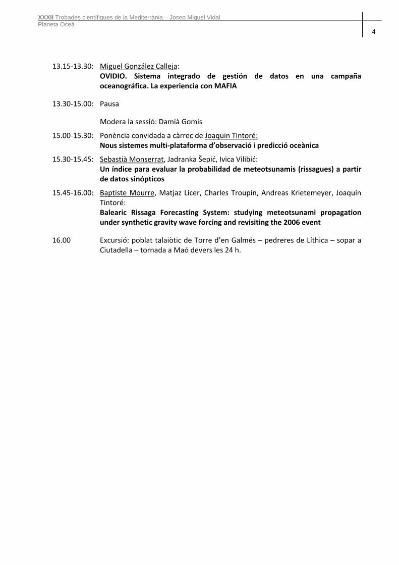
13.15‐13.30: Miguel González Calleja: OVIDIO. Sistema integrado de gestión de datos en una campaña
oceanográfica. La experiencia con MAFIA
13.30‐15.00: Pausa
Modera la sessió: Damià Gomis
15.00‐15.30: Ponència convidada a càrrec de Joaquin Tintoré: Nous sistemes multi‐plataforma d’observació i predicció oceànica
15.30‐15.45: Sebastià Monserrat, Jadranka Šepić, Ivica Vilibić: Un índice para evaluar la probabilidad de meteotsunamis (rissagues) a partir
de datos sinópticos
15.45‐16.00: Baptiste Mourre, Matjaz Licer, Charles Troupin, Andreas Krietemeyer, Joaquín Tintoré:
Balearic Rissaga Forecasting System: studying meteotsunami propagation under synthetic gravity wave forcing and revisiting the 2006 event
16.00 Excursió: poblat talaiòtic de Torre d’en Galmés – pedreres de Líthica – sopar a Ciutadella – tornada a Maó devers les 24 h.
XXXII Trobades científiques de la Mediterrània – Josep Miquel Vidal Planeta Oceà 5
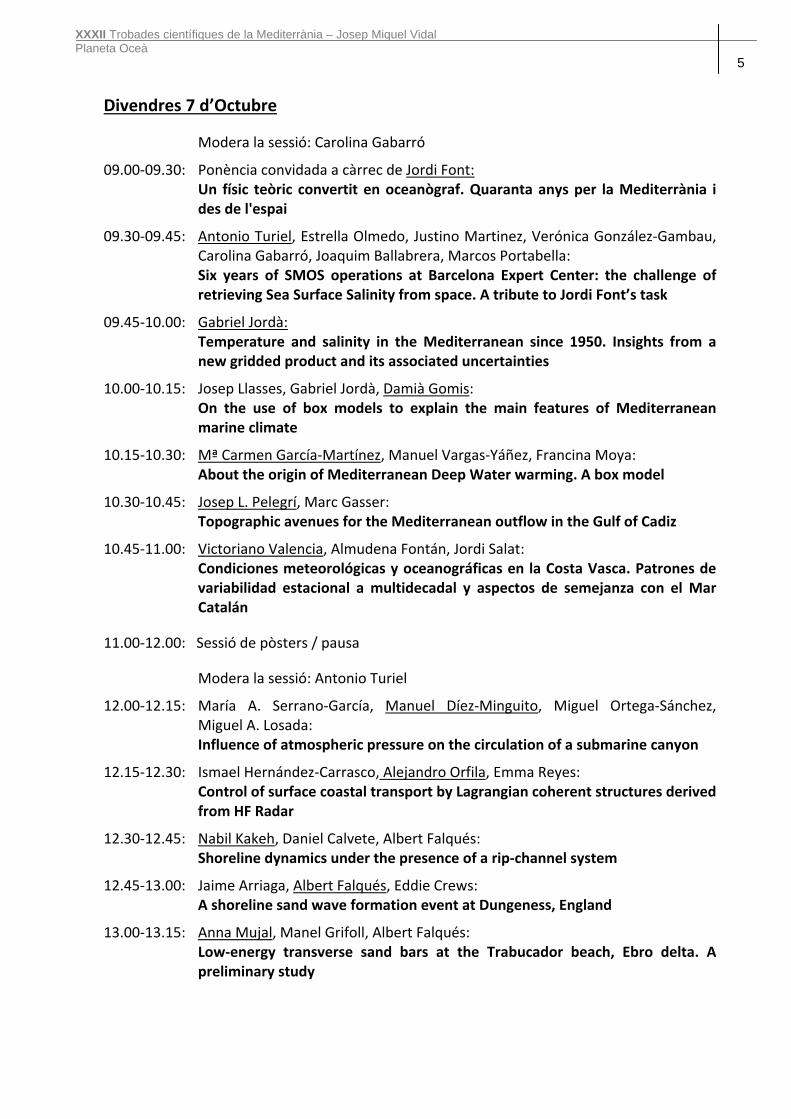
Divendres 7 d’Octubre
Modera la sessió: Carolina Gabarró
09.00‐09.30: Ponència convidada a càrrec de Jordi Font: Un físic teòric convertit en oceanògraf. Quaranta anys per la Mediterrània i
des de l'espai
09.30‐09.45: Antonio Turiel, Estrella Olmedo, Justino Martinez, Verónica González‐Gambau, Carolina Gabarró, Joaquim Ballabrera, Marcos Portabella:
Six years of SMOS operations at Barcelona Expert Center: the challenge of retrieving Sea Surface Salinity from space. A tribute to Jordi Font’s task
09.45‐10.00: Gabriel Jordà: Temperature and salinity in the Mediterranean since 1950. Insights from a
new gridded product and its associated uncertainties
10.00‐10.15: Josep Llasses, Gabriel Jordà, Damià Gomis: On the use of box models to explain the main features of Mediterranean
marine climate
10.15‐10.30: Mª Carmen García‐Martínez, Manuel Vargas‐Yáñez, Francina Moya: About the origin of Mediterranean Deep Water warming. A box model
10.30‐10.45: Josep L. Pelegrí, Marc Gasser: Topographic avenues for the Mediterranean outflow in the Gulf of Cadiz
10.45‐11.00: Victoriano Valencia, Almudena Fontán, Jordi Salat: Condiciones meteorológicas y oceanográficas en la Costa Vasca. Patrones de
variabilidad estacional a multidecadal y aspectos de semejanza con el Mar Catalán
11.00‐12.00: Sessió de pòsters / pausa
Modera la sessió: Antonio Turiel
12.00‐12.15: María A. Serrano‐García, Manuel Díez‐Minguito, Miguel Ortega‐Sánchez, Miguel A. Losada:
Influence of atmospheric pressure on the circulation of a submarine canyon
12.15‐12.30: Ismael Hernández‐Carrasco, Alejandro Orfila, Emma Reyes: Control of surface coastal transport by Lagrangian coherent structures derived
from HF Radar
12.30‐12.45: Nabil Kakeh, Daniel Calvete, Albert Falqués: Shoreline dynamics under the presence of a rip‐channel system
12.45‐13.00: Jaime Arriaga, Albert Falqués, Eddie Crews: A shoreline sand wave formation event at Dungeness, England
13.00‐13.15: Anna Mujal, Manel Grifoll, Albert Falqués: Low‐energy transverse sand bars at the Trabucador beach, Ebro delta. A
preliminary study

XXXII Trobades científiques de la Mediterrània – Josep Miquel Vidal Planeta Oceà 6
13.15‐13.30: Alejandra R. Enríquez, Marta Marcos, Damià Gomis, Amaya Álvarez‐Ellacuría, Alejandro Orfila:
Impact of sea level rise and waves under climate changes scenarios: a case study for the Cala Millor beach (Mallorca)
13.30‐15.00: Pausa
Moderalasessió:GabrielJordà
15.00‐15.30: Ponència convidada a càrrec de Alonso Hernández‐Guerra: Decadal variability of the meridional overturning transports in the Atlantic,
Indian and Pacific Oceans
15.30‐15.45: Dorleta Orue‐Echevarría, Francisco Machín, Josep L. Pelegrí: Mass transports at three different spatial scales in the Brazil‐Malvinas
Confluence
15.45‐16.00: Marta Masdeu, Dorleta Orue‐Echeverría, Josep L. Pelegrí, Jordi Isern, Mikhail Emelianov:
Ageostrophic velocity fields in Brasil‐Malvines Confluence
15.00‐16.15: Paola Castellanos, Olga T. Sato, Josep L. Pelegrí, Edmo J. D. Campos: A HYCOM representation of the South Atlantic and its impact on the tropical
ocean
16.15‐16.30: Veronica Nieves, Josh K. Willis: The effect of internal climate variability on surface temperature and sea level
16.30‐16.45: Marta Marcos, Sönke Dangendorf, Guy Wöppelmann: Progress in reconstructing long term global sea level changes
16.45‐17.00: Cloenda de les Trobades, a càrrec de: Josefina Salord, Coordinadora Científica de l’Institut Menorquí d’Estudis.

XXXII Trobades científiques de la Mediterrània – Josep Miquel Vidal Planeta Oceà 7
Pòsters
P1: Rosa Balbín, José Luis López‐Jurado, Alberto Aparicio, Verónica Caínzos, Raquel Gutiérrez, Juan Antonio Jiménez, Catalina Pasqual, Safo Piñeiro, Rocío Santiago, Mariano Serra:
The IEO physical oceanographic studies at the NE of Menorca deep station
P2: Nathanaële Lebreton, Noé Poffa: French operational instrumentation support to the Argo Program
P3: Yaiza M. Castillo, Dolors Vaqué, Elena Lara, Teresa S. Catalá, Mar Nieto‐Cid, Cristina Romera‐Castillo, Xose Anxelu G. Morán, Josep M. Gasol, Carlos M. Duarte, Cèlia Marrasé:
Do microbes contribute to the FDOM signature in the ocean?
P4: Jéröme Gourrion, Miquel Rosell‐Fieschi, Pierre Rousselot: Statistical comparison of ARGO‐ and SVP‐derived surface velocities
P5: Joaquín Salvador Castiella, Pedro Fernández Gallego, Jordi Font: El gran viaje de las boyas de deriva largadas en la campaña SPURS 2013
P6: Fiz F. Pérez, Montserrat Vidal: First estimation of the oceanic acidification in the Catalan Sea

XXXII Trobades científiques de la Mediterrània – Josep Miquel Vidal Planeta Oceà 8

XXXII Trobades científiques de la Mediterrània – Josep Miquel Vidal Planeta Oceà 9
Dimecres 5 d’Octubre
Marta Estrada: Patterns of phytoplankton distribution in stratified ocean waters
Mikel Latasa, Renate Scharek, Xelu Morán, Mikhail Emelianov, Jordi Salat, Marta Estrada: Dynamics of phytoplankton groups in the open NW Mediterranean
Sdena Nunes, Mikel Latasa, Pep Gasol, Marta Estrada: Seasonal dynamics of the phytoplankton community in the Bay of Blanes, NW Mediterranean Sea
Francesc Peters, Estela Romero, Rachele Gallisai, Òscar Guadayol: Seasonality of chlorophyll in the Mediterranean
Maurizio Ribera d’Alcalà, Angela Falciatore: Light signals in the ocean: the case of phytoplankton photoreceptors
Elisa Berdalet: Modulació de l’ecofisiologia del fitoplàncton marí per la turbulència de petita escala: del laboratori al medi natural
Miguel Cabrera, Celia Marrasé, Pedro Cermeño: Una aproximación experimental a la curva de remineralización de Martin: el efecto de la composición taxonómica de las comunidades fitoplanctónicas en la exportación de carbono a los fondos oceánicos
Beatriz Mouriño‐Carballido, Paloma Chouciño, Bieito Fernández, Miguel Gil Coto, Pedro Montero, Víctor Moreira‐Coello, Enrique Nogueira, Beatriz Reguera, Manuel Ruiz, Víctor Pelayo, Marina Villamaña: Occurrence of thin layers of phytoplankton in the Galician Rías
Francisco G. Figueiras, María Froján, Diana Zúñiga, Belén Arbones, Isabel G. Teixeira, Fernando Alonso‐Pérez, Carmen G. Castro: Size‐structure of microbial plankton and mussels in the Rías Baixas
Beatriz Reguera, Patricio Díaz, Lourdes Velo Suárez: Interacciones físico‐biológicas en poblaciones de fitoplancton nocivo en un sistema de afloramiento
Magda Vila, Rafael Abós‐Herràndiz, Jordi Isern‐Fontanet, Laia Viure, Èlida Alechaga, Soraya Hernández‐Llamas, Pilar Campos, Encarnación Moyano, Josep Àlvarez, Elisa Berdalet: Anàlisis de les proliferacions d’Ostreopsis cf. ovata associades a impactes sobre la salut humana a través d’una doble aproximació ecològica i epidemiològica
Maria Montserrat Sala, Encarna Borrull, Mireia Mestre, Susana Sánchez‐del Río, Carolina Antequera, Eva Ortega‐Retuerta, Andrea Malits, Fran Aparicio‐Bernat, Pere Puig, Josep Maria Gasol, Hans‐Peter Grossart, Cèlia Marrasé: Prokaryotic activity and diversity associated to particles in the NW Mediterranean
Renate Scharek, Mikel Latasa: Vertical flux of organic and lithogenic matter off the north‐eastern and northern coasts of the Spanish peninsula
Isabel Marín, Francesc Peters, Rachele Gallisai, Fran L Aparicio, Cèlia Marrasé, Riccardo Leardi, Xavier Querol: Nutrient deposition in coastal waters of the northwestern Mediterranean
Alba Medrano, Joan Lluis Riera, Eneko Aspillaga, Nathaniel Bensoussan, Pol Capdevila, Emma Cebrián, Rafel Coma, David Díaz, Bernat Hereu, Joaquim Garrabou, Jean‐Baptiste Ledoux, Ignasi Montero, Núria Teixidó, Eduard Serrano, Cristina Linares: Viabilitat dels boscos de gorgònia vermella a llarg termini davant fortes pertorbacions
Jaime Sintes, Beatriz Guijarro: Estat d’explotació dels ecosistemes i recursos demersals de Menorca
Cristóbal López, Emilio Hernández‐García, Enrico Ser‐Giacomi, Vincent Rossi: Lyapunov lines and flow networks: relevant tools to study marine ecosystems

XXXII Trobades científiques de la Mediterrània – Josep Miquel Vidal Planeta Oceà 10
Patterns of phytoplankton distribution in stratified ocean waters
Marta Estrada Institut de Ciències del Mar (CSIC), Barcelona [email protected] The presence of subsurface or deep chlorophyll maxima (DCM), resulting from a variable combination of increased phytoplankton biomass and enhanced chlorophyll content per cell, is a general feature in stratified marine waters. In this communication, we consider the large‐scale distribution patterns of the nano‐ and microphytoplankton (hereafter phytoplankton) collected during the Malaspina‐2010 Expedition (December 2010‐July 2011), which covered 15 biogeographical provinces across the Atlantic, Indian and Pacific oceans, and establish comparisons with observations from the NW Mediterranean. In general, because the Malaspina‐2010 cruise was carried out during the summer period of the different regions, the water column was well stratified and a marked DCM was found at depths between 60 and 150 m. Under these conditions, the phytoplankton was dominated by dinoflagellates, other flagellates, and coccolithophores, with localized spots of high diatom abundance. A multivariate analysis showed that the main trend of variability in the phytoplankton data corresponded to a contrast between the composition of the communities of the upper part of the euphotic zone and of the DCM. Thus, from a statistical point of view, differences in the phytoplankton assemblages living at depths some tens of meters apart can be larger than those between assemblages separated horizontally by hundreds or thousands of meters. These results of Malaspina‐2010 agree with findings from studies of the vertical distribution of phytoplankton in the NW Mediterranean.
XXXII Trobades científiques de la Mediterrània – Josep Miquel Vidal Planeta Oceà 11
Dynamics of phytoplankton groups in the open NW Mediterranean Mikel Latasa (1), Renate Scharek (1), Xelu Morán (1,2), Mikhail Emelianov (3), Jordi Salat (3), Marta Estrada (3) (1) Centro Oceanográfico de Gijón/Xixón (IEO), Gijón/Xixón, Asturias (2) King Abdullah University of Science and Technology (KAUST), Thuwal, Arabia Saudi (3) Institut Ciències del Mar (CSIC), Barcelona, Catalonia [email protected]
In 2009, the composition of phytoplankton was studied in the open NW Mediterranean (MEDOC area) during three key ecological situations: bloom (March‐April), post‐bloom (May) and late stratification (September). Pigments were quantified by HPLC and cells by flow cytometry and optical microscopy. Despite the great variability between stations within each cruise, statistical PCA analysis revealed that stations were more different inter‐cruises than intra‐cruises. The bloom period was very dynamic. We found an initial pre‐bloom situation with strong vertical mixing, and slightly more stratified waters towards the end of the cruise, when a diatom bloom started. A chlorophyll maximum was observed at surface rather than at depth. Prymnesiophytes were the next phytoplankton group in terms of abundance, while prasinophytes, pelagophytes and Synechococcus contributed more to the bulk phytoplankton during the first part of the cruise (the pre‐bloom). Dinoflagellates were residual. During the post‐bloom cruise the stations were also very heterogeneous. Two stations located south in the area presented a marked deep chlorophyll maximum (DCM) and were dominated by prymnesiophytes and pelagophytes, with a significant presence of diatoms in surface and low concentrations of Synechococcus, dinoflagellates and prasinophytes in general. On all other stations there was not a clear DCM. The highlight of this cruise was the massive dominance of Synechococcus on some stations and cryptophytes on others. In September the stations were more homogeneous. Here, prymnesiophytes dominated, with a significant presence of Synechococcus and Prochlorococcus along the water column, and pelagophytes at the DCM and below. Prasinophytes, cryptophytes and dinoflagellates were scarce. In terms of phytoplankton groups, diatoms dominated during the bloom situation and their importance decreased while stratification increased. Prymnesiophytes contributed always significantly ( ̴30%) to the bulk phytoplankton with a slight preference for surface layers. Synechococcus presented bloom concentrations in few stations of the post‐bloom cruise (to our knowledge a first report of this kind in the NW Mediterranean), and significant concentrations during all cruises. Cryptophytes were in general very scarce except in some very shallow samples of few stations during the post‐bloom cruise. Pelagophytes contributed around 20% at depth during the post‐bloom and late stratification cruises. Prochlorococcus appeared only in the late stratification cruise and especially in the top layers of the DCM. Prasinophytes were present in all situations. Photosynthetic dinoflagellates were always residual.

XXXII Trobades científiques de la Mediterrània – Josep Miquel Vidal Planeta Oceà 12
Seasonal dynamics of the phytoplankton community in the Bay of Blanes, NW Mediterranean Sea Sdena Nunes (1), Mikel Latasa (2), Pep Gasol (1), Marta Estrada (1) (1) Marine Biology and Oceanography Department ‐ Institute of Marine Science – Barcelona ‐ Catalunya, Spain (2) Spanish Institute of Oceanography – Gijón ‐ Asturias, Spain [email protected]
The seasonal variations of phytoplankton dynamics in surface waters of the Bay of Blanes (NW Mediterranean) were characterized during 14 years (2000 – 2014), based on biomarker pigment determinations. Pigment concentrations were determined by means of the HPLC method and the contribution of the main phytoplankton groups to total Chlorophyll a (Chla) was assessed through the application of the CHEMTAX (CHEMical TAXonomy) program. The most abundant phytoplankton groups were: Diatoms, prasinophytes, haptophytes “group 6+7”, haptophytes “group 8” and Synechococcus. Other detected groups were: core chlorophytes, dinoflagellates, cryptomonads, pelagophytes and Prochlorococcus. On average, diatoms dominated during some winter and spring months, and were abundant again in November. Prasinophytes presented the highest concentrations from December to March, decreased gradually between April and September, and increased again at the beginning of October. Synechococcus, which was practically absent during the winter period, was abundant between June and October, accounting for 39% of the total Chla in September. Haptophytes “group 6+7” showed their greatest concentration between April and October, while haptophytes “group 8” were more abundant in late autumn and winter. The variability of the phytoplankton community is discussed in relationship with the seasonal changes of environmental factors such as temperature, stratification and nutrient availability. The data showed also substantial interannual variation, highlighting the importance of time series for understanding coastal environment dynamics in a context of global change.
XXXII Trobades científiques de la Mediterrània – Josep Miquel Vidal Planeta Oceà 13
Seasonality of chlorophyll in the Mediterranean
Francesc Peters (1), Estela Romero (1), Rachele Gallisai (1), Òscar Guadayol (2) (1) Institut de Ciències del Mar (CSIC), Barcelona, Catalunya(2) Physical Ecology Lab, University of Lincoln, Lincoln, UK
Annual phytoplankton dynamics in the Mediterranean Sea are strongly driven by the seasonal overturning in winter‐spring when deep waters rich in essential nutrients are mixed with upper sunlit waters. Being in the subtropical highs zone, with relatively low wind energy and variability, only enhances the seasonal component. We have analyzed the seasonality of chlorophyll using 8‐d averaged 1 x 1 degree satellite data for the whole basin and higher spatial resolution in certain areas. We calculated the Seasonality Index (SI) as the proportion of the variance owing to annual recurrent trends with respect to total time series variance. The index is calculated either from spectral analysis or using a statistical cubic spline adjustment for multiyear data. The SI is high in general of 75% or more. Some areas influenced by large rivers (Rhone, Po, Nile) and other areas such as the Alboran Sea where Atlantic waters enter the Mediterranean, the northern Aegean Sea with the influence from the Black Sea through the Sea of Marmara or the Gulf of Gabes with a shallow shelf and coastal enrichment all show decreased seasonality and a larger annual chlorophyll signal. If the variability for frequencies larger than the annual can be interpreted as a results of disturbances to the system that force nutrients into the euphotic zone, there is room for addressing ecological hypotheses that relate disturbance to system diversity and production, and to use this information in the frame of global change scenarios.

XXXII Trobades científiques de la Mediterrània – Josep Miquel Vidal Planeta Oceà 14
Light signals in the ocean: the case of phytoplankton photoreceptors
Ribera d’Alcalà Maurizio (1), Falciatore Angela (2) (1) Stazione Zoologica Anton Dohrn, Napoli, Italy
(2) Laboratory of Computational and Quantitative Biology, Université Pierre et Marie Curie, Paris, France.
Aquatic photosynthesis and the light as a source of energy are likely the most studied topics in biological oceanography. Much less is known on the light as a source of information especially for what phytoplankton concerns. It is only after the systematic use of molecular approaches that the tiles of the mosaic are starting to be put together and from those a highly tangled scenario is appearing. Most of the known photoreceptors are present in phytoplanktonic organisms, often in multiple variants and covering different wavebands. The reconstruction of the evolutionary origin and the function of those photoreceptors is still at a preliminary stage but evidence is accumulating of their involvement in fundamental mechanisms of phytoplankton biology. Even photoreceptors usually responding in Red‐Far Red region of the spectrum, e.g., phytochrome, seem to be widespread, despite their spectral characteristics make their presence counterintuitive in the red absorbing water column.
Focusing mostly on diatoms we are trying to dissect the function of both blue and red photoreceptors, with the latter exhibiting counterintuitive spectral shifts which lead us to consider new hypotheses on the putative light triggering their response. Interestingly, diatoms are the group with quite complex life strategies, which includes intensive blooms, sexual phases, dormant stages, spore production, chain formation etc. In each of those phase photoreceptors may play an important role, which in some cases has been unveiled. More important, merging ocean optics, molecular biology and plankton ecology allows to formulate testable hypotheses on the function of photoreceptors in phytoplankton and to better understand their evolutionary history. Starting from the analysis of our recent results on diatom photoreceptors we will discuss to what extent the presence of regulative mechanisms, possibly mediated by the former, may change our view on phytoplankton biology.

XXXII Trobades científiques de la Mediterrània – Josep Miquel Vidal Planeta Oceà 15
Modulació de l’ecofisiologia del fitoplàncton marí per la turbulència de petita escala: del laboratori al medi natural
Elisa Berdalet, Marta Estrada Departament de Biologia Marina i Oceanografia, Institut de Ciències del Mar (ICM‐CSIC), Barcelona [email protected] El model conceptual conegut com la Mandala de Margalef (1978) que postulava el papel fonamental de la turbulència en l'estructura i dinàmica dels ecosistemes planctònics, va marcar una fita en la història de l'ecologia aquàtica. El model proposa una sistematització de la morfologia del fitoplàncton en funció de la distribució de nutrients i la intensitat de turbulència. Si bé la Mandala s'adreçava a la comprensió de la dinàmica del fitoplàncton a nivell de mesoscala en el medi natural, tenia implicacions també en la petita escala cel∙lular. La Dra. Marta Estrada, deixebla directa del Dr. Margalef, va inspirar tota una línia de recerca centrada en desvetllar els efectes directes de la turbulència de petita escala en el fitoplàncton. Entre els diferents aspectes estudiats, aquesta presentació se centra en els relacionats amb les dinoflagel∙lades, un grup especial de microalgues implicat sovint en el fenomen conegut com a "proliferacions algals nocives" (Harmful Algal Blooms, HABs, en anglès). Les HABs són events naturals que causen diversos problemes en la salut humana, l'economia i el medi ambient. Les proliferacions de dinoflagel∙lades acostumen a produir‐se en condicions de calma i estabilitat de la columna d'aigua. Els diversos experiments (una bona part realitzats a l'Institut de Ciències del Mar, ICM‐CSIC) han aportat evidències empíriques sobre la interferència de la turbulència de petita escala en els fluxos de metabòlits a través de la membrana cel∙lular, la morfologia i el volum cel∙lulars, el contingut en DNA, toxines i DMSP en les cèl∙lules, els cicles de vida (encistament) i divisió cel∙lular, i la motilitat. Éssent les dinoflagel∙lades especialment sensibles, les respostes dels organismes són força específiques (depenents de la mida i forma de les cèl∙lules) i afectades per l'aproximació experimental. En una altra escala, la turbulència també afectaria les interaccions depredador‐presa i hoste‐paràsit. Aquests estudis poden trobar‐se per exemple a Berdalet i Estrada (2008). Els principals reptes actuals són esbrinar els mecanismes intrínsics implicats en les respostes observades i integrar aquestes processos de petita escala per a millorar el nostre coneixement dels fenòments naturals de les HABs. Els processos ecofisiològics a petita escala són un component més de la complexitat de factors físico‐químics i biològics, que interaccionen entre sí a més gran escala i als quals els organismes reaccionen amb una varietat d'estratègies, encara no ben conegudes. Margalef (1978) Oceanologica Acta 1: 493‐509. Berdalet i Estrada (2008) A: J. Gilabert (ed.), 1‐12.
XXXII Trobades científiques de la Mediterrània – Josep Miquel Vidal Planeta Oceà 16
Una aproximación experimental a la curva de remineralización de Martin: el efecto de la composición taxonómica de las comunidades fitoplanctónicas en la exportación de carbono a los fondos oceánicos
Miguel Cabrera, Celia Marrasé, Pedro Cermeño Departamento de Oceanografía y Biología Marina/ICM‐CSIC, Barcelona [email protected]
La intensidad y eficiencia de la bomba biológica, responsable de la captura de CO2 atmosférico y su exportación hacia el océano profundo en forma de carbono orgánico, depende de i) los niveles de nutrientes inorgánicos que limitan la producción primaria marina y ii) la susceptibilidad de la materia orgánica a la degradación bacteriana. En general los modelos del sistema Tierra asumen que la producción primaria marina se recicla en la columna de agua de acuerdo con un perfil de remineralización pre‐establecido (la curva de Martin). La forma del perfil de remineralización controla la cantidad de carbono orgánico que queda retenido en las capas profundas del océano y en los sedimentos. Sin embargo, la forma de dicho perfil, que depende del origen de la materia orgánica particulada, está pobremente caracterizada. En esta presentación mostramos la influencia de la composición taxonómica de las comunidades fitoplanctónicas en el perfil de remineralización de la materia orgánica. A partir de muestras de agua superficial del Mediterráneo occidental, y mediante la adición de dos tratamientos de nutrientes diferentes, se indujeron en el laboratorio dos proliferaciones de fitoplancton: una dominada por diatomeas y otra dominada por cocolitofóridos. El material particulado generado en cada uno de las proliferaciones fue transferido a mesocosmos con agua profunda del Mediterráneo Durante las 3 semanas que duró el experimento se analizaron las concentraciones de nutrientes inorgánicos, abundancia de bacterias y diferentes variables químicas dirigidas a caracterizar los patrones de degradación de la materia orgánica particulada y disuelta. Nuestros resultados ponen de manifiesto diferencias significativas en los perfiles de remineralización asociados a cada una de las proliferaciones. Esta información puede utilizarse para cuantificar la eficiencia de la bomba biológica en los ambientes dominados por estos dos grupos funcionales y obtener estimaciones más precisas de captura de CO2 atmosférico por los ecosistemas del océano.
XXXII Trobades científiques de la Mediterrània – Josep Miquel Vidal Planeta Oceà 17
Occurrence of thin layers of phytoplankton in the Galician Rías
Beatriz Mouriño‐Carballido (1), Paloma Chouciño (1), Bieito Fernández (1), Miguel Gil Coto (2), Pedro Montero (3), Víctor Moreira‐Coello (1), Enrique Nogueira (4), Beatriz Reguera (4), Manuel Ruiz (5), Víctor Pelayo (1), Marina Villamaña (1) (1) Universidad de Vigo, Vigo (2) Instituto Investigaciones Marinas‐ CSIC, Vigo(3) INTECMAR (4) Instituto Español de Oceanografía, Vigo (5) Instituto Español de Oceanografía, Coruña
Thin layers of phytoplankton (TLP) are a particular case of phytoplankton blooms that occur when large numbers of photosynthetic cells are located within a narrow depth interval. Many toxic species, including Pseudo‐nitzschia australis and Dinophysis spp., form TLP. These features are believed to play an important role in the long‐term maintenance and sudden formation of harmful algae blooms. Diverse physical mechanisms related to turbulence conditions can be responsible for the formation of TLP. Straining of phytoplankton patches by shear occurs because horizontal gradients of scalars can be transformed into vertical gradients, due to vertical gradients in the horizontal velocity field. Shear can favor thin layer formation via straining or gyrotactic trapping, but it can also trigger hydrodynamic instabilities and turbulence that dissipate layers. A limited number of studies have described the occurrence of TLP in the Galician Rías so far. Despite this evidence, the frequency of occurrence of TLP in the Galician Rías, and the role of mixing conditions in their formation and persistence remains unknown. The INTECMAR (Instituto Tecnolóxico para o Control do Medio Mariño de Galicia) carries out weekly samplings in 43 oceanographic stations in the Rías of Vigo, Pontevedra, Arousa, Muros‐Noia and Ares‐Betanzos. At each station hydrographic conditions and abundance of harmful phytoplankton species are characterized. This high frequency and spatial resolution sampling provides a highly valuable database to characterize the frequency of occurrence, spatial distribution and intensity of TLP in the Galician Rías. The analysis of the dataset collected by the INTECMAR between 2012‐2015 shows that TPL occur more frequently at the Ría de Pontevedra than at the Ría de Vigo. High frequency observations carried out with a microstructure turbulence profiler, in the same region and during the same period, indicate that the INTECMAR sampling clearly underestimate these events, as TLP form and destroy over short periods of time, in response to changes in mixing conditions that occur in a few hours.

XXXII Trobades científiques de la Mediterrània – Josep Miquel Vidal Planeta Oceà 18
Size‐structure of microbial plankton and mussels in the Rías Baixas Francisco G. Figueiras (1), María Froján (1), Diana Zúñiga (2), Belén Arbones (1), Isabel G. Teixeira (3), Fernando Alonso‐Pérez (1), Carmen G. Castro (1) (1) Instituto de Investigacións Mariñas, CSIC, Vigo, Spain (2) Applied Physics Department, University of Vigo, Vigo, Spain (3) CESAM & Departamento de Biologia, Universidade de Aveiro, Aveiro, Portugal [email protected]
The Rías Baixas are four bays located on the NW Iberian Peninsula that support the highest mussel production in Europe and one of the most important in the world. Here we show that this high mussel production is related to the presence in the water column of large microbial plankton species, as mussel organic ingestion rate and absorption efficiency are strongly correlated with microplankton carbon content. In addition, significantly lower biomass of microplankton and nanoplankton are regularly recorded in mussel farming zones compared to the unaffected mussel culture areas, whereas picoplankton does not seem to be a suitable food for mussels. Dominance of microplankton (mainly diatoms but also large dinoflagellates) in the microbial plankton community of the Rías regularly occurs from spring to autumn, due to seasonal coastal upwelling. The intrusion and progressive uplift of subsurface nutrient‐rich water is enhanced into the Rías Baixas due to their bathymetry, promoting diatom growth. In contrast, microplankton dominance in the adjacent shelf waters is not so evident; being their presence restricted to strong upwelling events. Nanoplankton prevails in these adjacent shelf waters during the major part of the year, with picoplankton attaining higher importance under non‐upwelling conditions. It is hypothesised that a possible future decline in upwelling intensity and frequency caused by global warming can lead to a decrease in microplankton dominance and so a drop in mussel production in the Rías.

XXXII Trobades científiques de la Mediterrània – Josep Miquel Vidal Planeta Oceà 19
Interacciones físico‐biológicas en poblaciones de fitoplancton nocivo en un sistema de afloramiento
Beatriz Reguera (1), Patricio Díaz (2), Lourdes Velo Suárez (3) (1) IEO, Centro Oceanográfico de Vigo, Microalgas Nocivas, Vigo(2) Programa de Investigación Pesquera & Instituto de Acuicultura, Universidad Austral de Chile, Puerto Montt, Chile (3) IFREMER, Centro de Brest, Plouzané, Francia
[email protected] Las proliferaciones recurrentes de poblaciones de fitoplancton productoras de toxinas diarreicas (dinoflagelados del género Dinophysis) y amnésicas (diatomeas del género Pseudo‐nitzschia) en la costa Atlántica europea constituyen la principal amenaza para los productores de bivalvos en viveros flotantes o en bancos naturales. El impacto de los eventos de fitoplancton tóxico es especialmente fuerte en las costas del noroeste Ibérico. En esta región, el poderoso sector mejillonero contempla impotente cada año prolongados cierres de recolección (de hasta 9 meses de duración en “puntos calientes”) cada vez que los niveles de toxinas en carne de bivalvos supera los límites establecidos por directivas de la UE como aptos para el consumo humano. En un sistema de afloramiento como el de las Rías Baixas gallegas, donde los intercambios de agua ría‐plataforma son muy dinámicos, la mejor mitigación posible es la mejora de la predicción. El objetivo último, el desarrollo de una oceanografía operacional en la que la densidad de especies objetivo y el riesgo de intoxicación de los bivalvos se estime con al menos la misma escala espacio‐temporal que la predicción meteorológica local. Este desarrollo requiere tener un buen modelo físico de circulación y un conocimiento sólido de la biología y de las interacciones físico‐biológicas de múltiple escala, específicas de especie (comportamiento), que se superponen. En esta presentación se mostrarán ejemplos, específicos de especie, de interacción de las poblaciones de especies nocivas a distintas escalas: a) variabilidad interanual (hasta 30 años), en relación con cambios del patrón de afloramiento o anomalías regionales [1,2]; b) Variabilidad estacional, incluyendo el uso de modelos de transporte físico [3,4]; c) Variabilidad de microescala, en particular la formación de capas finas, que se han podido estudiar con el apoyo de instrumentación física de alta resolución espacio temporal y con la estimación de parámetros biológicos (tasas de división, status fisiológico) de las microalgas [5,6]. [1] Díaz, P.A., Ruiz‐Villarreal, M., Pazos, Y. et al. 2016. Harmful Algae 53: 145‐159.
[2] Díaz, P.A., Reguera, B., Ruiz‐Villarreal M. 2013. Mar. Drugs 11: 2964‐2981. [3] Ruiz‐Villarreal, M., García‐García, L., Cobas, M. et al. 2016. Harmful Algae 53: 40‐52. [4] Velo‐Suárez, L., González‐Gil, S., Pazos et al. 2014. Deep‐Sea Res.Pt II 101: 141‐151. [5] Díaz, P.A., Ruiz‐Villarreal, M., Velo‐Suárez, L. et al. 2014. Deep‐Sea Res.Pt II 101: 163‐179. [6] Velo Suárez, L., González‐Gil, S., Gentien, P. et al. 2008. Limnol. Oceanogr. 53: 1816‐1834.

XXXII Trobades científiques de la Mediterrània – Josep Miquel Vidal Planeta Oceà 20
Anàlisis de les proliferacions d’Ostreopsis cf. ovata associades a impactes sobre la salut humana a través d’una doble aproximació ecològica i epidemiològica
Magda Vila (1), Rafael Abós‐Herràndiz (2), Jordi Isern‐Fontanet (1), Laia Viure (1), Èlida Alechaga (3), Soraya Hernández‐Llamas (1), Pilar Campos (1), Encarnación Moyano (3), Josep Àlvarez (4), Elisa Berdalet (1) (1) Institut de Ciències del Mar (ICM‐CSIC), Barcelona (2) Institut Català de la Salut (Generalitat de Catalunya), Barcelona(3) Facultat de Química, Universitat de Barcelona, Barcelona (4) Agència de Salut Pública de Catalunya(Generalitat de Catalunya), Barcelona [email protected] Les proliferacions de la dinoflagel∙lada bentònica Ostreopsis cf. ovata en algunes platges del Mediterrani s’han relacionat amb símptomes respiratoris aguts esporàdics i malestar general en las persones exposades als aerosols marins. No obstant, la relació directa entre les proliferacions recurrents d’Ostreopsis i els problemes en la salut no s’han establert clarament. Per tal d’establir aquesta connexió es va realitzar un estudi ecològic i epidemiològic conjunt en una platja afectada per aquests episodis. Durant la proliferació, que es va estendre des de finals de juny fins a finals d’octubre de 2013, el 81% de la cohort humana estudiada va presentar almenys un símptoma relacionat amb els potencialment produïts per l’Ostreopsis. Paradoxalment, la majoria dels efectes van tenir lloc durant un breu període de temps, a principis d’agost, coincidint amb la transició de la fase de creixement exponencial de la proliferació a la fase estacionària. A partir d’agost i fins a mitjans d’octubre, en la fase estacionària caracteritzada per elevades concentracions d’O. cf. ovata, els símptomes van ser negligibles. Durant el període de temps amb més afectació en la salut no es van observar patrons clars del component de vent de mar cap a terra. Durant els anys 2014‐2016 es repeteix l’estudi amb l’objectiu d’incrementar la cohort humana a analitzar. Al mateix temps es pretén contextualitzar l’episodi del 2013 en un marc plurianual. La nostra hipòtesis principal és que els compostos irritants presents en l’aerosol es produeixen durant una fase fisiològica particular de las cèl∙lules d’Ostreopsis en un moment concret de la proliferació, el final de la fase exponencial i principi de la fase estacionària. Durant la proliferació de 2016 es plantegen experiments per estudiar la ecofisiologia de l’Ostreopsis en les diferents fases de creixement.

XXXII Trobades científiques de la Mediterrània – Josep Miquel Vidal Planeta Oceà 21
Prokaryotic activity and diversity associated to particles in the NW Mediterranean
Maria Montserrat Sala (1), Encarna Borrull (1), Mireia Mestre (1), Susana Sánchez‐del Río (1), Carolina Antequera (1), Eva Ortega‐Retuerta (1), Andrea Malits (2), Fran Aparicio‐Bernat (1), Pere Puig (1), Josep Maria Gasol (1), Hans‐Peter Grossart (3), Cèlia Marrasé (1) (1) Institut de Ciències del Mar (CSIC), Barcelona(2) Centro Austral de Investigaciones Científicas (CADIC‐CONICET), Ushuaia, Argentina(3) Leibniz Institute for Freshwater Ecology and Inland Fisheries (IGB), Stechlin, Germany [email protected]
The decomposition of particulate matter has always been considered one of the major pathways in the recycling of nutrients in the oceans. Organic particles may constitute a niche for prokaryotes that may harbor specific bacterial communities different to those in the surrounding water and a hot‐spot of bacterial activity. We investigated prokaryotic abundance, diversity, production and extracellular enzyme activities together with particle concentration in a cruise from the coast to the open ocean in the NW Mediterranean. Our results showed decreasing prokaryotic activity and extracellular enzyme activities with depth. However in layers of increased turbidity, i.e. bottom nepheloid layers (BNL), increased chitinolytic activity and lower proteolytic activity was found, suggesting that prokaryotes in nepheloid layers rely more on chitin than proteins for C and N acquisition. In terms of diversity, the composition of the free‐living prokaryotic community of the deepest station (2300m) was similar between the nepheloid layer and bathypelagic waters. However, the attached prokaryotic community differed considerably. Specifically, Archaea contributed a higher percentage (12.6%) to the attached community in nepheloid layers than in bathypelagic waters (5.2%).

XXXII Trobades científiques de la Mediterrània – Josep Miquel Vidal Planeta Oceà 22
Vertical flux of organic and lithogenic matter off the north‐eastern and northern coasts of the Spanish peninsula
Renate Scharek, Mikel Latasa CO Gijón (IEO), Gijón, Asturias [email protected] Vertical flux of particulate matter to greater depths has been measured in the winter deep convection zone in the Gulf of Lyon (NW Mediterranean ) and south of the Banco Le Danois off the Asturian coast (Bay of Biscay, NW Atlantic). In order to follow the seasonal sedimentation cycle we used moored sediment traps with automated opening and closing systems. In terms of oceanographic settings both areas present open ocean spring blooms, observable by satellite, which are dominated by typical bloom diatom assemblages. Maxima of matter export, recorded as dry weight, did not coincide with expected patterns. There were no maxima after the spring bloom but they occurred one month before the bloom in the Gulf of Leon and during July in the area of the Banco Le Danois. The observed patterns can be explained in part by the high proportion of lithogenic material, which contributed half or more of the mass flux during the whole year in both areas. The export of spring bloom material could be identified by the distinct elemental composition (particulate carbon and nitrogen, biogenic silica, δ15N) of the sinking biogenic material in both areas. A striking difference was the much lighter nitrogen isotopic composition (δ15N) of the NW Mediterranean in comparison to the Atlantic sinking material observed during the whole year.

XXXII Trobades científiques de la Mediterrània – Josep Miquel Vidal Planeta Oceà 23
Nutrient deposition in coastal waters of the northwestern Mediterranean
Isabel Marín (1), Francesc Peters (1), Rachele Gallisai (1), Fran L Aparicio (1), Cèlia Marrasé (1), Riccardo Leardi (2), Xavier Querol (3)
(1) Institut de Ciències del Mar, Barcelona(2) Università degli Studi di Genova, Genova(3) Instituto de Diagnóstico Ambiental y Estudios del Agua, Barcelona [email protected]
The Mediterranean Sea is a low‐nutrient, low‐chlorophyll region, characterized by a marine planktonic community limited predominantly by phosphorus (P), or P along with nitrogen (N) in the northwestern basin (NW). In this context, the deposition of nutrients from the atmosphere may play an important role, especially during the stratification period, when thermocline prevents mixing of nutrient‐rich deep waters into the photic zone. Two main sources of atmospheric particles have been identified in the NW Mediterranean: continuous antropogenically‐derived emissions from Europe and local sources, and episodic Saharan dust events. We provide data of atmospheric fluxes of inorganic nutrients and total organic carbon (TOC) in an urban coastal location of the NW Mediterranean. Bulk deposition of nitrate, nitrite, ammonium, phosphate, silicate, and TOC was measured from May, 2011 to January, 2016, using passive collectors. Nitrate and nitrite followed opposite seasonal patterns, nitrate deposition flux being higher during the spring‐summer period and nitrite during autumn. TOC deposition was also higher during spring, whereas the other nutrients did not follow any seasonal pattern but large peaks were associated to point events, as Saharan intrusions. Mean deposition fluxes were 127, 14, 175, 5, 7, and 521 µmol m‐2 d‐1, for nitrate, nitrite, ammonium, phosphate, silicate and TOC, respectively. Both N and P fluxes were much higher than values reported in more pristine areas of the Mediterranean (e.g., Markaki et al. 2010), but a similar N:P ratio was determined, whereas very low Si:N and Si:P ratios were determined. These results provide evidence of a higher anthropogenic footprint for N and P than for silicate. A principal component analysis revealed that silicate deposition was highly correlated with the presence of atmospheric particles from the Saharan desert and with wind speed, mainly associated to dryfall. On the other hand, nitrate, phosphate, TOC, and in a lesser extend, nitrate and ammonium, were more correlated with accumulated rainfall, suggesting that wet deposition is more common for these nutrients. Although ecological implications are difficult to estimate for larger spatial and temporal scales, these results suggest that an increasing trend in anthropogenic atmospheric inputs (rich in N, P and TOC) could drive the planktonic coastal system to an increase in primary production of non‐siliceous phytoplankton cells, concomitant with an increase in bacterial production, at certain times of the year, with the consequent risk of eutrophication.
XXXII Trobades científiques de la Mediterrània – Josep Miquel Vidal Planeta Oceà 24
Viabilitat dels boscos de gorgònia vermella a llarg termini davant fortes pertorbacions Alba Medrano (1), Joan Lluis Riera (1), Eneko Aspillaga (1), Nathaniel Bensoussan (5), Pol Capdevila (1), Emma Cebrián (3), Rafel Coma (3), David Díaz (4), Bernat Hereu (1), Joaquim Garrabou (1), Jean‐Baptiste Ledoux (1), Ignasi Montero (1,2), Núria Teixidó (2), Eduard Serrano (3), Cristina Linares (1,2) (1) Departament d’Ecologia/Universitat de Barcelona (2) Institut de Ciències del Mar/CSIC (3) Centre d’Estudis Avançats de Blanes /CEAB‐CSIC (4) Instituto Español de Oceanografía / IEO‐Mallorca (5) Université de' Aix‐Marseille, Centre d'Océanologie de Marseille
[email protected] En el context actual de canvi global, les projeccions climàtiques per al Mediterrani prediuen l’increment en la freqüència i la persistència de pertorbacions derivades de l’activitat humana, el que representa una amenaça important per al coral∙ligen, un dels hàbitats mediterranis que presenta una major biodiversitat i complexitat estructural. Aquest estudi avalua la resiliència, la dinàmica de la recuperació a llarg termini i la futura viabilitat d’una espècie clau en l’estructuració i funcionament d’aquest ecosistema, la gorgònia vermella (Paramuricea clavata), després de l’episodi de mortalitat en massa de l’any 1999 al Parc Nacional de Port Cros (Provença, França). Aquesta mortalitat es va relacionar amb una de les anomalies tèrmiques positives més importants de les últimes dècades. Les dades demogràfiques recollides al llarg de 10 anys després de la pertorbació ens mostren patrons de recuperació variables en dues poblacions situades dins del Parc Nacional, amb canvis en l’estructura de talles i en la dinàmica d’aquestes poblacions. Les Anàlisis de Viabilitat de Poblacions prediuen un alt risc d’extinció d’aquestes poblacions en les condicions actuals, el que es veuria accentuat amb l’increment de pertorbacions, tant locals com regionals. Els resultats d’aquest estudi evidencien la necessitat d’implementar mesures de gestió que redueixin la mortalitat de les colònies de mida gran i la importància del reclutament de nous individus en el manteniment i distribució d’aquestes poblacions en el futur.

XXXII Trobades científiques de la Mediterrània – Josep Miquel Vidal Planeta Oceà 25
Estat d’explotació dels ecosistemes i recursos demersals de Menorca Jaime Sintes (1,3), Beatriz Guijarro (2,3)
(1) Universitat de les Illes Balears, Palma (2) Institut Espanyol d’Oceanografia ‐ Centre Oceanogràfic de Balears, Palma (3) Estació d’Investigació “Jaume Ferrer”, La Mola (Menorca)
Per les seves peculiars característiques, les Illes Balears se consideren un àrea individualitzada per a l’avaluació i gestió de les pesqueries [1]. Malgrat l’avaluació dels principals recursos pesquers de les Balears indica que es troben en un estat de sobreexplotació [2], s’ha de tenir en compte que aquests estudis inclouen majoritàriament dades de Mallorca. Si bé fins ara no s'havien fet estudis específics a nivell d'illa, les anàlisis preliminars suggerien que Menorca podria presentar característiques diferents a les de la resta d’illes, en quant a un millor estat de conservació dels ecosistemes i recursos explotats per la pesqueria de ròssec [3]. L’objectiu d’aquesta comunicació és avaluar, per primera vegada, l’estat dels ecosistemes i els recursos explotats per la flota de ròssec de Menorca.
L’anàlisi s’ha fet tant a nivell de comunitat com a nivell poblacional, considerant les espècies objectiu d’aquesta pesqueria, de manera semblant al que ja s’havia fet per Mallorca [4]. S’han utilitzat dues fonts d’informació: (i) dades obtingudes del seguiment científic estacional de la flota de ròssec de Maó (2012‐2015); i (ii) dades provinents de les campanyes de recerca MEDITS, que es fan anualment al voltant de Mallorca i Menorca (2001‐2015). A nivell específic, s’han utilitzat indicadors com la freqüència d’aparició, els índexs de biomassa i abundància estandarditzats, el centre de gravetat, així com altres indicadors basats en les talles i l’índex de condició. A més, s’ha analitzat la comunitat mitjançant indicadors de densitat (abundància i biomassa estandarditzades), diversitat (número total d’espècies i riquesa específica) i indicadors basats en l’estructura poblacional (espectres de diversitat, abundància i/o biomassa i talla i pes màxims). Finalment, s’ha realitzat l’avaluació de l’estat d’explotació mitjançant metodologies utilitzades habitualment en grups de treball internacionals com l’anàlisi de cohorts (LCA) i l’anàlisi de rendiment per recluta (YR). Totes aquestes anàlisis han permès avaluar l’evolució temporal d’aquests indicadors, a més de fer una comparativa espaial amb la informació disponible a Mallorca. Els resultats d’aquest projecte ens permeten augmentar el coneixement de les poblacions demersals explotades per la flota de ròssec a l’illa de Menorca, la qual cosa pot ajudar a millorar les mesures de gestió que s’apliquen per aconseguir la sostenibilitat de la pesqueria i fer‐la compatible amb la protecció del medi marí.
[1] Quetglas A, Guijarro B, Ordines F, Massutí E (2012) Stock boundaries for fisheries assessment and management in the Mediterranean: the Balearic Islands as a case study. Scientia Marina, 76(1): 17‐28. [2] GFCM (2015) Report of the Working Group on Stock Assessment of Demersal Species (WGSAD). General Fisheries Commission for the Mediterranean. Roma (Itàlia), 23‐38 Novembre 2015. [3] Gouraguine A, Hidalgo M, Moranta J, Bailey DM, Ordines F, Guijarro B, Valls M, Barberá C, Quetglas A, De Mesa A (2011) Spatial segregation between deep water elasmobranch species related to biological and environmental factors. Scientia Marina, 75(4): 653‐664. [4] Guijarro B, Tserpes G, Moranta J, Massutí E (2011). Assessment of the deep water trawl fishery off the Balearic Islands (western Mediterranean): from single to multi‐species approach. Hydrobiologia, 670: 67‐85.
XXXII Trobades científiques de la Mediterrània – Josep Miquel Vidal Planeta Oceà 26
Lyapunov lines and flow networks: relevant tools to study marine ecosystems
Cristóbal López (1), Emilio Hernández‐García (1), Enrico Ser‐Giacomi (1), Vincent Rossi (1) (1) IFISC, Instituto de Física Interdisciplinar y Sistemas Complejos, Palma de Mallorca, Spain
(2) Ecole Normale Superieure, Paris [email protected]‐csic.es
In the last years there have been important advances in the Lagrangian description of transport and mixing in the oceans borrowing concepts and tools from dynamical systems theory. In this presentation I will focus on two complemenary tools: Lagrangian Coherent Structures (LCS) as obtained with Lyapunov Exponents, and Flow networks. I will present their main theoretical properties and how they can be related. Concerning oceanic applications, I will discuss the way they define barriers and/or avenues to transport and allow studying the connectivity patterns of marine populations, providing a systematic characterization of larval transport and dispersal.

XXXII Trobades científiques de la Mediterrània – Josep Miquel Vidal Planeta Oceà 27
Dijous 6 d’Octubre
Jordi Salat: Una visió personal i transferible sobre oceanografia d'ahir, d'abans d'ahir, però també d'avui i potser de demà. Alguns temes oberts i d'altres potser tancats de manera un pèl provisional
Jaume Piera, Luigi Ceccaroni, Bernat L. Claramunt: Natusfera: a new platform to integrate citizen science approaches for monitoring marine ecosystems
Jaime Arriaga, Jantien Rutten, Albert Falqués, Francesca Ribas, Gerben Ruessink: The potential risk induced by climate change in the context of mega‐nourishments
Celia Marrasé, Rachele Gallisai, Isabel Marín, Francisco L. Aparicio, Sdena Nunes, E Denisse Sánchez‐Pérez, Francesc Peters: Atmospheric inputs in the Mediterranean may modulate its colour
Antonio García‐Olivares: Energía para una sociedad post‐carbono sostenible
Enric Massutí, Bàrbara Terrassa, Olga Reñones, Gema Jiménez, Pere Oliver: L’Estació d’Investigació “Jaume Ferrer” (La Mola, Menorca)
Carolina Gabarro, Estrella Olmedo, Joaquim Ballabrera, Antonio Turiel: Monitoring sea surf‐ace salinity at the Arctic Ocean and high latitude oceans using SMOS data
Jordi Isern‐Fontanet, Antonio Turiel, Estrella Olmedo, Cristina González‐Haro: Reconstruction of ocean currents from existing satellite observations: the challenge of high resolution dynamics
Miquel Rosell Fieschi, Jerôme Gourrion, Ignasi Vallès, Josep L. Pelegrí: Velocitats inferides a partir dels perfiladors Argo: un conjunt de dades infravalorat? L'Oceà Atlàntic Sud a vista d'Argo
Ignasi V. Casanova, Miquel Rosell‐Fieschi, Jeröme Gourrion, Josep L. Pelegrí: Anàlisi comparatiu entre velocitats inferides a partir de boies Argo i derivadors superficials i la seva resposta vers el vent superficial
Ananda Pascual, Laura Gómez‐Navarro, Guillaume Valladeau, Simón Ruiz, Francesco D’Ovidio, Evan Mason, Antonio Sánchez‐Román, Pascal Bonnefond, Nicolas Picot: Mesoscale and sub‐mesoscale characterization from multi‐platform experiments: anticipating SWOT launch
Miguel González Calleja: OVIDIO. Sistema Integrado de Gestión de Datos en una Campaña Oceanográfica. La experiencia con MAFIA
Joaquin Tintoré: Nous Sistemes Multi‐Plataforma d’Observació i Predicció Oceànica
Sebastià Monserrat, Jadranka Šepić, Ivica Vilibić: Un índice para evaluar la probabilidad de meteotsunamis (rissagues) a partir de datos sinópticos
Baptiste Mourre, Matjaz Licer, Charles Troupin, Andreas Krietemeyer, Joaquín Tintoré: Balearic Rissaga Forecasting System: studying meteotsunami propagation under synthetic gravity wave forcing and revisiting the 2006 event

XXXII Trobades científiques de la Mediterrània – Josep Miquel Vidal Planeta Oceà 28
Una visió personal i transferible sobre l'oceanografia d'ahir, d'abans d'ahir, però també d'avui i potser de demà. Alguns temes oberts i d'altres potser tancats de manera un pèl provisional
Jordi Salat Institut de Ciències del Mar, Barcelona
Fa quatre dies, com aquell qui diu, que estudiem l’oceà. El punt de vista que m’agradaria transferir a través de la presentació és, en primer lloc, el d’admiració envers aquells que varen llançar‐se al buit des d’un vaixell, armats de tot tipus d’estris que sovint podríem assimilar a “màquines de fer ploure”. També aquells que segueixen recollint dades amb paciència i amb la percepció que cada una d’elles és tot un món i mereix una explicació. Gràcies a tots ells disposem de descripcions prou precises per començar a entendre el què està passant al nostre petit planeta. Si situem l’ahir al començament de l’electrònica i l’avui, a l’explosió de les comunicacions i la capacitat de fer càlculs astronòmics en picosegons, aquest serà l’interval de temps en què ens centrarem per intentar mostrar com veig l’evolució de l’oceanografia que he tingut el plaer de viure en primera persona. De manera directa o a través de lectures ‐no sempre fàcils d’entendre‐, de converses amb els companys i també amb alguns grans mestres. Sempre amb la il∙lusió d’intentar obrir noves perspectives amb nous mètodes… amb la sensació d’anar més lluny, o potser de descobrir la sopa d’all (garlic soup? No. Reinventing the wheel, I presume!) Penso en incloure un parell (en sentit illenc) d’anècdotes d’aquest període i, sense cercar cap mena de significació estadística, miraré de transferir algunes conclusions personals relatives a problemes plantejats des d’abans d’ahir. Veurem què dóna de sí, tot plegat.

XXXII Trobades científiques de la Mediterrània – Josep Miquel Vidal Planeta Oceà 29
Natusfera: a new platform to integrate citizen science approaches for monitoring marine ecosystems
Jaume Piera (1), Luigi Ceccaroni (2), Bernat L. Claramunt (3) (1) Dep. d'Oceanografia Física i Tecnològica. ICM‐CSIC. Barcelona
(2) 1000001 Labs. Barcelona
(3) CREAF‐UAB. Barcelona
Marine ecosystems are characterized by an extraordinary mix of human activities, e.g.: tourism, fishing and industry (petrochemical plants and aquaculture, etc.). New policies concerning environmental resources should have citizens’ support and consider public attitudes from the beginning. The development of these policies is becoming more complex with larger datasets required to support the assessment of impacts on whole ecosystems over long periods of time. Access to the considerable funding needed for data collection is limited, so it is important to look at new cost‐effective ways of obtaining and processing environmental data.
Citizen science has the potential to increase the knowledge base about marine ecosystems through the participation of people with no specific scientific training to collect and analyze large data sets. In this contribution we introduce the new, open citizen science platform called “Natusfera” (natusfera.gbif.es). Inspired by the existing platform iNaturalist, one of the main goals of this new platform is to facilitate the participation of any community interested in collaborating in environmental monitoring, independently of the community size and the capabilities of their members. To do so, the Natusfera development has been conceived to break three main potential barriers: (1) Technological barriers. Communities will not require having ICT expertise in the group to run Natusfera and to adapt it to their particular interest. (2) Knowledge barriers. Communities may start participating even if they do not have the expertise to identify/interpret their own observations. (3) Linguistic barriers. The users will be able to choose freely the language to participate and exchange information in Natusfera. At present the platform is available in five languages: English, Spanish, Catalan, Galician and Euskera. The platform is now being adapted to support as many languages as possible using a system for collaborative translation.
As examples of management of observations, we present the integration in Natusfera of (1) a service that will allow to report changes in water transparency usign a do‐it‐yourself instrument (KdUINO) developed in the framework of the Citclops project (Citizens’ Observatory for Coast and Ocean Optical Monitoring, www.citclops.eu); and (2) a service that will allow to record sound (for bioacoustics’ research) and include the following information units: (a) sound record, (b) geo‐location, (c) community interaction, (d) identification, (e) associated project, and (f) data‐quality assessment. The long term goal is to provide an open platform that can easily extend its observation and management capabilities.
XXXII Trobades científiques de la Mediterrània – Josep Miquel Vidal Planeta Oceà 30
The potential risk induced by climate change in the context of mega‐nourishments
Jaime Arriaga (1), Jantien Rutten (2), Albert Falqués (1), Francesca Ribas (1), Gerben Ruessink (1) (1) Department of Physics/UPC, Barcelona(2) Department of Physical Geography/UU, Utrecht [email protected]
Beach nourishments are intended to remediate the lack of sand on beaches due to natural and human processes. Their increase in frequency and size in the last years is partly due to subsidence and sea level rise. Stive et al. (2013) proposed a mega‐nourishment in the Dutch coast 10 to 100 times bigger than the traditional ones, the ZandMotor (ZM), to fight climate change. The ZM was designed with a 2.4 km width to work with the forces of nature (longshore sand transport induced by waves) diffusing the sand along about 17 km.
Such large nourishment changes the bathymetry, perturbing wave transformation from deep water. The perturbation effect becomes more important with obliquely‐incident waves, reducing the diffusivity of the nourishment. For very obliquely incident waves it even can cause a negative diffusivity, which could induce shoreline undulations with erosional hot spots at the adjacent coast of the nourishment.
The objective of the present work is to study the importance of the incident‐wave angles in the long term (>30 yr) and the risk that a changing climate can have at such large space and time scales. For this purpose we calibrate the Q2D‐morfo morphodynamic model (van den Berg et al., 2012), which is based on the longshore transport induced by waves, with 3‐yr data of the ZM and we explore the future behavior on the basis of the uncertainty of future wave climate.
We find that if the wave climate remains statistically similar to the present one the proportion of high‐angle waves, 60% (angle with respect to shore normal in deep water larger than 45o), is not large enough to cause negative diffusivity. However, the ZM lifetime is of 80 yr instead of the 20‐yr‐designed lifetime, probably due to that large proportion of high‐angle waves. Secondly we explore which changes in the future wave climate could de‐stabilize the ZM causing a negative diffusivity and the generation of large‐scale shoreline undulations along the adjacent coast.
Van den Berg, A. Falqués and F. Ribas, Modelling large scale shoreline sand waves under oblique wave incidence. JGeophys.Res., 117(F03019), 2012. Stive et al., A new alternative to saving our beaches from sea‐level rise: The sand engine. Coastal Eng., 29(5): 1001–1008, 2013.

XXXII Trobades científiques de la Mediterrània – Josep Miquel Vidal Planeta Oceà 31
Atmospheric inputs in the Mediterranean may modulate its color
Celia Marrasé, Rachele Gallisai, Isabel Marín, Francisco L. Aparicio , Sdena Nunes, E Denisse Sánchez‐Pérez and Francesc Peters Institut de Ciències del Mar – CSIC, Barcelona [email protected]
The dynamics of the coloured fraction of dissolved organic matter (CDOM) in marine systems is of high interest because this fraction is optically active. CDOM absorbs UV and visible light and thus affects the pelagic microorganisms in two ways: it reduces the light availability for photosynthesis and diminishes the cell damage induced by UV radiation. Major sources of CDOM are continental runoff and in situ production by microorganisms. Interestingly, Mediterranean waters exhibit exceptionally high values of CDOM to chlorophyll (Chl) ratio when comparing them with those of waters from other marine basins. We, in this study, explored the possible importance of atmospheric material deposition in modulating the amount of the CDOM in an area influenced by anthropogenic aerosols and also by episodic events of Sahara winds, which are associated with high dust deposition rates. To address this question we collected samples for atmospheric deposition (at the roof of the Institute of Marine Sciences (ICM‐CSIC) in Barcelona) and for seawater analyses (at 0.5 km offshore of Barcelona) over a two‐year period (September 2012 ‐ July 2014). We investigate, during this period, the dynamics of CDOM and also of a subfraction of this organic matter, the fluorescent dissolved organic matter (FDOM). Our observations indicate that DOM composition measured with optical techniques varied when Saharan wind events occurred and also evidence an increase in the FDOM flux during these events. We will discuss our findings in relation to organic matter remineralization in surface Mediterranean waters.

XXXII Trobades científiques de la Mediterrània – Josep Miquel Vidal Planeta Oceà 32
Energía para una sociedad post‐carbono sostenible Antonio García‐Olivares Instituto de Ciencias del Mar‐CSIC, Barcelona [email protected]
Una forma posible de evitar el riesgo de declive energético y luchar contra el cambio climático sería construir un sistema energético global 100% renovable. Un sistema de energía renovable (ER) se podría escalar hasta el rango de 12 terawatios de electricidad (TWE) si el 10% de las plataformas continentales fueran explotadas con molinos flotantes hasta profundidades de unos 225 m, 5% de los continentes con turbinas terrestres, y el 5% de los principales desiertos fueran utilizados para estaciones de concentración solar (CSP). Sin embargo, una economía electrificada a nivel mundial no puede crecer muy por encima de 12 TWE sin acercarse al límite de las reservas globales de cobre. Los paneles fotovoltaicos (PV) de silicio más recientes no utilizan metalizaciones de plata y podrían contribuir con hasta 1 TW de energía residencial descentralizada. La hidroelectricidad tiene un potencial de 1 TW aunque una fracción de ello tendría que ser sacrificado con fines de almacenamiento de energía. Hidroelectricidad, CSP, energía de las olas y redes integradas de escala continental pueden ser suficientes para ajustar la oferta a la demanda, evitando la intermitencia. El nuevo mix eléctrico tendría una Tasa de Retorno Energético (TRE) de alrededor de 18,25% menos que la TRE actual estimada. Eso debería ser suficiente para sostener una economía industrializada, siempre que la sustitución de los combustibles fósiles por electricidad se haga de forma inteligente.

XXXII Trobades científiques de la Mediterrània – Josep Miquel Vidal Planeta Oceà 33
L’Estació d’Investigació “Jaume Ferrer” (La Mola, Menorca) Enric Massutí (1,3), Bàrbara Terrassa (2,3), Olga Reñones (1,3), Gema Jiménez (2,3), Pere Oliver (1,3)
(1) Instituto Español de Oceanografía, Centre Oceanogràfic de Balears, Palma (2) Direcció General d’Innovació i Recerca del Govern de les Illes Balears, Palma (3) Estació d’Investigació “Jaume Ferrer”, 07700 Maó
[email protected]; [email protected] L'Estació d'Investigació "Jaume Ferrer" s’inaugurà el 2009 i està cogestionada per la Conselleria d'Innovació, Recerca i Turisme del Govern dels Illes Balears (CAIB) i el Instituto Español de Oceanografía (IEO), com a responsables de la direcció institucional i científica, respectivament. Situada en una bateria de la Fortalesa de la Mola, cedida pel Ministeri de Defensa a la CAIB, té com a finalitat: (i) establir un entorn còmode per a l'execució de projectes de recerca a Menorca; (ii) aportar coneixement cientificotècnic sostingut en el temps, per a millorar la gestió del medi marí de l'Illa; i (iii) crear un espai adequat per a la formació de post‐grau. L'Estació compta amb personal permanent per mantenir la infraestructura, desenvolupar programes de seguiment científic i donar suport logístic als grups de recerca que hi accedeixen. Disposa d'allotjament, laboratori, despatxos i equipament per a la presa de dades, imatges i mostres al mar, el seu pretractament, conservació i anàlisi en laboratori. Recentment també s'ha instal∙lat un laboratori per a l'experimentació amb organismes vius. Les principals activitats realitzades han estat: (i) posar en marxa i/o consolidar programes de seguiment científic; (ii) desenvolupar projectes d'investigació experimental i de transferència de tecnologia i coneixement científic; i (iii) activitats de formació i divulgació. Entre els primers, destaquen el seguiment d'algues invasores, realitzat amb el Centre d'Estudis Avançats de Blanes del CSIC i dels blancalls, juntament amb la Universitat de Barcelona, que han permès transformar estudis previs puntuals d'aquestes entitats, en programes de seguiment estables. A més, s'ha col∙laborat amb el Sistema d'Observació Costaner de les Illes Balears (SOCIB) en el monitoratge de les condicions fisicoquímiques i la hidrodinàmica del port de Maó, s'ha iniciat el mostreig i l'avaluació de les pesqueres de Menorca, en col∙laboració amb el programa de la Comissió Europea per a la recopilació, gestió i ús de dades del sector pesquer i, amb el Consell de Menorca, s'ha potenciat l'estudi de la pesquera de llagosta vermella. Entre els projectes d'investigació experimental destaca la restauració de l'alga Cystoseira barbata al port de Maó, i la tesi doctoral "Settlement and post‐settlement processes of Mediterranean littoral fishes: Influence of Seascape attributes and environmental conditions at different spatial scales". Com a projectes de transferència, assenyalar els realitzats amb la Confraria de Pescadors de Maó, per incorporar noves tecnologia que milloren la selectivitat i eficiència energètica de la pesca de ròssec, i el Pla de Vigilància Ambiental del dragat del port de Maó, a requeriment de la Autoritat Portuària de Balears. En formació destaquen les pràctiques del màster d'Ecologia Marina de la Universitat dels Illes Balears i, en difusió, els seminaris científics "Diàlegs d'avall s'Aigua", organitzats amb l'Institut Menorquí d'Estudis. Entre 2010 i 2015, 16 grups de recerca han utilitzat les infraestructures científiques i d’allotjament de l'Estació, que han dut a terme estudis sobre Posidonia oceanica, algues, gorgònies, peixos i aus marines a Menorca, així com biodiversitat, hidrodinàmica i bio‐geoquímica, contaminació, microbiologia, tecnologies marines i arqueologia. Per a més informació: www.ba.ieo.es/es/estacion‐jaume‐ferrer; www.balearsfaciencia.org/estacionsinvestigacio/.

XXXII Trobades científiques de la Mediterrània – Josep Miquel Vidal Planeta Oceà 34
Monitoring sea surface salinity at the Arctic Ocean and high latitude oceans using SMOS data
Carolina Gabarro, Estrella Olmedo, Joaquim Ballabrera, Antonio Turiel Dep. Oceanografia Física i Tecnològica / Institut de Ciencies del Mar (ICM),Barcelona [email protected]
In recent years, the Arctic Ocean has been under significant transformation as shown by numerous in‐situ and remote sensing measurements. The temperature of the upper layer of the Arctic Ocean has been increasing and more solar heat has been absorbed by the increasing ice‐free areas [1,2]. The launch of the Soil Moisture and Ocean Salinity (SMOS) mission, in 2009, marked the dawn of a new type of space‐based microwave observations. Although the mission was originally conceived for hydrological and oceanographic studies [3,4], SMOS is also making inroads in the cryospheric sciences. SMOS carries an L‐band (1.4 GHz, or 21‐cm wavelength), passive interferometric radiometer (the so‐called MIRAS) that measures the electromagnetic radiation emitted by the Earth’s surface, at about 50 km spatial resolution, full polarization, continuous multi‐angle viewing, large wide swath (1200‐km), and with a 3‐day revisit time at the equator, but more frequently at the poles.
With the introduction of a new retrieval methodology, it is now possible to retrieve salinity information in ice‐free areas of the Arctic Ocean, a key region for monitoring the extent and rate of climate change. The quality of the sea surface salinity (SSS) retrievals in the Arctic region, will be presented, for which a rather exhaustive validation with in situ data (ARGO, EN4 and vessel measurements) has been performed as well as a comparison with the TOPAZ model output. It is shown that, with the current accuracy, it is possible to monitor the spatial and temporal variability of the salinity close to the mouth of the main Arctic river
[1] Comiso, J. C. (2012), Large decadal decline of the arctic multiyear ice cover, doi:10.1175/jcli‐d‐11‐00113.1., J. Clim, 25 (3), 11761193. [2] Haas, C., A. Pfa_ing, S. Hendricks, L. Rabenstein, J.‐L. Etienne, and I. Rigor (2008), Reduced ice thickness in arctic transpolar drift favors rapid ice retreat, doi:10.1029/2008gl034457., Geophys. Res. Lett., 35. [3]Font, J.; Camps, A.; Borges, A.; Martin‐Neira, M.; Boutin, J.; Reul, N.; Kerr, Y.; Hahne, A. & Mecklenburg, S. SMOS: The Challenging Sea Surface Salinity Measurement From Space Proceedings of the IEEE, no. 5, 2010, 98, 649 ‐665 [4] Kerr, Y.; Waldteufel, P.; Wigneron, J. P..; Delwart, S.; Cabot, F.; Boutin, J.; Escorihuela, M.J..; Font, J.; Reul, N.; Gruhier, C.; Juglea, S.; Drinkwater, M.; Hahne, A.; Martin‐Neira, M. & Mecklenburg, S. The SMOS mission: New tool for monitoring key elements of the global water cycle Proc. IGARSS 2010, no. 5, 2010, 98, 666‐687

XXXII Trobades científiques de la Mediterrània – Josep Miquel Vidal Planeta Oceà 35
Reconstruction of ocean currents from existing satellite observations: the challenge of high resolution dynamics
Jordi Isern‐Fontanet(1), Antonio Turiel (1), Estrella Olmedo (1), Cristina González‐Haro (2) (1) Institut de Ciències del Mar (CSIC), Barcelona(2) Télécome Bretagne, Plouzané [email protected] Infrared and visible satellite observations have revealed that the ocean surface is crowded with eddies with scales O(10 ‐100 km) and submesoscale structures, like fronts and filaments, with scales O(1‐10 km). Satellite infrared measurements of Sea Surface Temperature (SST) have resolutions high enough to observe submesoscales (~ 1 km), and the existence of multiple platforms with infrared sensors can provide observations of the same area with temporal samplings of less than 6 h. The key problem to be addressed is the extraction of quantitative dynamical information at the scales of interest from existing observations. Indeed, along‐track altimetric measurements of Sea Surface Heights (SSH) are very well suited to quantify across‐track currents. However, the spatial resolution of derived 2D velocities is restricted to scales above 100‐150 km and the limited number of altimeters can lead to errors in the location of currents. To overcome the previous constrains, new theoretical frameworks that model the dynamics of the upper ocean have been proposed. Here, we discuss the strengths and weakness of dynamical approaches like the Surface Quasi‐Geostrophic (SQG) equations to retrieve the three‐dimensional dynamics of the ocean as well as other approaches that exploit the synergy between SST and SSH measurements to provide enhanced 2D surface currents. Recent results showing the current capabilities to retrieve the velocity field at scales of the order of 10 km will be also shown. Nevertheless, in areas such as the Mediterranean Sea salinity plays a key role. Consequently, the capability to retrieve the topology of the flow from satellite measurements of Sea Surface Salinity will be also discussed.
XXXII Trobades científiques de la Mediterrània – Josep Miquel Vidal Planeta Oceà 36
Velocitats inferides a partir dels perfiladors Argo: un conjunt de dades infravalorat? L'Oceà Atlàntic Sud a vista d'Argo
Miquel Rosell Fieschi (1), Jerôme Gourrion (2), Ignasi Vallès (1), Josep L. Pelegrí (1) (1) Departament d'Oceanografia Física i Tecnològica, ICM‐CSIC, Barcelona (2) Centre National de la Recherche Scientifique (CNRS), DivisionTechnique de l’Institut de Sciences de l’Univers (DT‐INSU), Plouzané, France
El potencial dels perfiladors Argo per extraure les velocitats oceàniques ha quedat ja manifest en diversos estudis anteriors (Ollitrault, 2006, 2013; Lebedev, 2007; Rosell‐Fieschi et al., 2013, 2015). Després de més de 9 anys de dades amb la flota de perfiladors completa, el volum d'informació es notable, car el conjunt total de perfiladors proporciona més de cent mil vectors de velocitat anuals. Això ja és suficient no només per descriure els grans patrons de circulació sinó també per aprofundir en l'estudi de la dinàmica estacional a una resolució ja raonable –1º a arreu o fins i tot 1/2º en algunes regions.
Malgrat tot, la difusió d'aquest valuós conjunt de dades i el seu ús són encara escassos. És per aquest motiu que val la pena mostrar les possibilitats que ofereixen les velocitats inferides de les posicions de la xarxa Argo, exemplificades amb una exploració de l'oceà Atlàntic Sud i Equatorial, presentant figures i eines elaborades exclusivament amb aquestes dades.
La mera visualització per components ja conté informació rellevant, però mostrarem com es poden elaborar productes derivats – el càlcul de la funció de corrent o l'elaboració d'un petit model de propagació de partícules virtuals – que ens ajudin, per exemple, a estudiar els temps de circulació, o els patrons de propagació de les masses d'aigua. Totes aquestes eines aporten una millora substancial de la visualització i comprensió de la dinàmica oceànica.

XXXII Trobades científiques de la Mediterrània – Josep Miquel Vidal Planeta Oceà 37
Anàlisi comparatiu entre velocitats inferides a partir de boies Argo i derivadors superficials i la seva resposta vers el vent superficial Ignasi V. Casanova(1), Miquel Rosell‐Fieschi(1), Jeröme Gourrion(2), Josep L. Pelegrí (1) (1) Institut de Ciències del Mar de Barcelona, ICM‐CSIC (2) Centre National de la Recherche Scientifique (CNRS), Division Technique de l’Institut de Sciences de l’Univers (DT‐INSU), Plouzané, France [email protected] Obtenir mesures empíriques de la dinàmica superficial ha estat sempre una tasca primordial per entendre la interacció oceà‐atmosfera i millorar la predicció del clima. A partir dels anys 80 els derivadors del programa de velocitats superficials (surface velocity program, SVP), amb draga a 15 m, han estat el principal mètode Lagrangià d'observació de les corrents oceàniques en la primera capa superficial. Recentment, el posicionament dels perfiladors Argo en superfície també ha estat utilitzat per deduir el camp de velocitats superficials per tots els mars i oceans. Aquest mètode ha demostrat ser molt potent a la hora de determinar corrents superficials tant a nivell global com regional, i també ha permès descriure amb gran exactitud la seva dinàmica estacional (Davis 2005, Lebdev et al. 2007, Ollitrault and Rannou 2013, Rosell‐Fieschi et al., 2013, 2015). Tot i el creixent increment de la base de dades, tant SVP com Argo, i la millora del seu processat, encara no hi ha un estudi exhaustiu que compari els dos camps de velocitats per tal de validar les velocitats inferides dels perfiladors Argo. El treball presentat és un anàlisi comparatiu entre els dos camps de velocitats, SVP i Argo, utilitzant diferents paràmetres estadístics, amb l'objectiu principal de validar la metodologia de deducció de velocitats a partir de perfiladors Argo. La comparativa també incorpora dades de vent superficial per tal d'analitzar la correlació entre els tres camps de velocitats, amb el propòsit d’entendre millor les diferents respostes dels perfiladors Argo i derivadors SVP vers al vent. Davis, R. E., (2005), Intermediate‐depth circulation of the Indian and South Pacific Oceans measured by autonomous floats. J. Phys. Oceanogr., 35, 683‐707. Lebedev, K. V., H. Yoshinari, N. A. Maximenko, P. W. Hacker, (2007), YoMaHa ’07: Velocity data assessed from trajectories of Argo floats at parking level and at the sea surface. IPRC Tech. Note, 4(2), 16 pp. Ollitrault, M., J. P. Rannou, (2013), ANDRO: An Argo‐based deep displacement dataset. J. Atmos. Oceanic Technol., 30, 759‐788. Rosell‐Fieschi, M., S. R. Rintoul, J. Gourrion, J. L. Pelegrí, (2013), Tasman Leakage of intermediate waters as inferred from Argo floats. Geophys. Res. Lett., 40, 5456‐5460. Rosell‐Fieschi, M., J. L. Pelegrí, J. Gourrion, (2015), Zonal jets in the equatorial Atlantic Ocean. Progr. Oceanogr., 130, 1‐18.

XXXII Trobades científiques de la Mediterrània – Josep Miquel Vidal Planeta Oceà 38
Mesoscale and sub‐mesoscale characterization from multi‐platform experiments: anticipating SWOT launch
Ananda Pascual (1), Laura Gómez‐Navarro (1), Guillaume Valladeau (2), Simón Ruiz (1), Francesco D’Ovidio (3), Evan Mason (1), Antonio Sánchez‐Román (1), Pascal Bonnefond (4), Nicolas Picot (5) (1) IMEDEA(CSIC‐UIB), Esporles (2) CLS, Toulouse, France (3) LOCEAN, Paris, France (4) Observatoire de Paris, Paris, France (5) CNES, Toulouse, France [email protected]‐csic.es
Since the early 90’s, several altimetry missions provide accurate measurements of sea surface height. The overall quality assessment of altimeter data can be performed by analyzing their internal consistency and the cross‐comparison between all missions. As a complementary approach, in‐situ measurements, (including CTD, ADCP, gliders, drifters, HF radar, tide gauges, moorings,…) are used as an external and independent reference to enable further quality assessment of the altimeter sea level and provide a better estimate of the multiple altimeter performances. Considered as a new generation of altimetry mission and a big breakthrough in Earth observation, the wide‐swath SWOT mission, will provide simultaneous high‐resolution and large coverage images to characterize meso‐ and sub mesoscale 2D surface ocean circulation. In order to fulfill its primary objectives and anticipate the 2D SSH fields that will be provided by SWOT, this study aims to identify the several in‐situ techniques available for the monitoring of the mesoscale and sub‐mesoscale structures and their contribution to upper‐ocean interior exchanges. Thanks to the combination of such external and independent instruments, the comparison with SWOT will be facilitated. In the context of the international SWOT NASA/CNES science team, we propose a high‐resolution experiment in the Western Mediterranean Sea, where mesoscale and submesoscale processes include the formation, evolution and dissipation of eddy variability associated with narrow currents, fronts, filaments and quasi‐geostrophic turbulence. Special attention will be devoted to separate the scales typically resolved by the present altimeter gridded products constellation (i.e. order 100 km) compared to the scales that will be observed by SWOT (wavelengths down to 15‐50 km). This experiment will contribute to the preparatory cal/val activities of the mission that will provide during the fast phase after launch daily high resolution sea surface height measurements in certain areas of the Global Ocean.

XXXII Trobades científiques de la Mediterrània – Josep Miquel Vidal Planeta Oceà 39
OVIDIO. Sistema integrado de gestión de datos en una campaña oceanográfica. La experiencia con MAFIA
Miguel González Calleja
Servicio de Sistemas de Información Geográfica, IMEDEA (UIB‐CSIC), Esporles (Illes Balears)
[email protected]‐csic.es
La eficiencia en el desarrollo de proyectos ambientales y las exigencias en las bases de proyectos de envergadura (Plan Nacional, H2020...), impelen al desarrollo de herramientas que integren todo el ciclo de datos. La experiencia recogida en la colaboración del servicio SIG de IMEDEA en el proyecto MAFIA "Migrants and Active Flux in the Atlantic Ocean" durante el año 2015 a bordo del BIO Hespérides, ha permitido desarrollar y evaluar la "suite" de herramientas OVIDIO (Oceanographic Vessel Wireless Data Integrator). OVIDO permite la gestión integrada de los datos de una campaña oceanográfica: Gestión de estadillos de muestreo usando dispositivos móviles (tablets, smartphones...) Transmisión de datos de las capturas usando la WIFI del buque. Integración de los datos de muestreo con los sensores del buque (estación meteorológica,
información del puente, del continuo) Gestión de muestras (codificación, etiquetado con código de barras, informes de muestreo) Gestión de la planificación de las maniobras Generación automática de metadatos ISO 19139 Generación automática de informes Consolidación de la plataforma de trabajo en el centro de investigación mediante el uso de
máquinas virtuales, accesibles a nivel mundial por aplicaciones basadas en servicios web. La presentación versará sobre la experiencia y validación de la herramienta en la mencionada campaña oceanográfica y el actual desarrollo de un interfaz flexible para su reutilización en campañas oceanográficas y en proyectos ambientales en tierra. Siendo esta, una herramienta susceptible de incorporarse a proyectos que incorporen WP exigentes en gestión de datos.
XXXII Trobades científiques de la Mediterrània – Josep Miquel Vidal Planeta Oceà 40
Multi‐platform observing and forecasting system
Joaquín Tintoré (1,2) and all the SOCIB team (1) SOCIB ‐Sistema de Oceanografía Costera de les Illes Balears‐, Parc Bit, Palma (2) IMEDEA (CSIC‐UIB), Esporles, Mallorca [email protected]; www.socib.es New monitoring technologies are key components of recent observing systems being progressively implemented in many coastal areas of the world oceans. As a result, new capabilities to characterise the ocean state and its variability at small scales exists today in many cases in quasi‐real time. The real challenge for the next decade is the integration of theses technologies and multiplatform observing and forecasting systems to (a) monitor the variability at small scales (e.g. mesoscale/weeks) in order (b) to resolve the sub‐basin/seasonal and inter‐annual variability and by this (c) establish the decadal variability, understand the associated biases and correct them. The Mediterranean Sea is a well‐known reduced scale ocean, an ideal natural laboratory to study global ocean processes, in particular those associated with meso and submesoscale variability, interactions with mean flows and associated ecosystem response. SOCIB, the Balearic Islands Coastal Ocean Observing and Forecasting System, is one of such new ocean observatories, a multi‐platform distributed and integrated system, a facility of facilities that extends from the nearshore to the open sea. SOCIB takes profit of the strategic position of the Balearic Islands at the Atlantic/Mediterranean transition area, one of the ‘hot spots’ of biodiversity in the world’s oceans and also, of the real science based sustainability needs in islands where preservation of the environment is essential to assure, both residents welfare and the competitiveness of the tourist sector. SOCIB is unique in that, from peer‐reviewed excellence, its mission and objectives are science, technology and society driven. The know‐how, data, tools and products developed and made available for scientists and society are a clear performance indicator of SOCIB achievements and innovations in a new era of ocean observation. Some examples from SOCIB Observing, Forecasting and data Centre Facilities will be presented and discussed. These types of new marine infrastructures, because of their critical mass and sustained funding, are presently establishing new ways of international cooperation leading to major science breakthroughs, innovations in oceanographic instrumentation and new ways of more efficient and science based coastal and ocean management. Tintoré, J., Vizoso, G., Casa, B., Heslop, E., Pascual, A., Orfila, A., et al. (2013). SOCIB: The Balearic Islands
coastal ocean observing and forecasting system responding to science, technology and society needs. Mar.
Technol. Soc. J., 47(1), 101‐117
XXXII Trobades científiques de la Mediterrània – Josep Miquel Vidal Planeta Oceà 41
Un índice para evaluar la probabilidad de meteotsunamis (rissagues) a partir de datos sinópticos
Sebastià Monserrat (1), Jadranka Šepić (2), Ivica Vilibić (2) (1) Department de Física, Universitat de les Illes Balears, Ctra.Valldemossa, km. 7.5, Palma (2) Institute of Oceanography and Fisheries, ŠetališteI. Meštrovića 63, 21000 Split, Croatia [email protected]
En la actualidad se dispone de una considerable red de sismógrafos y mareógrafos que, incorporados a sistemas de alerta sofisticados y a procesos de toma de decisiones en tiempo real, permite que la mayor parte de tsunamis lleguen a la costa tras haberse producido una alerta previa. Esto no ocurre así con los meteotsunamis, que afectan ciertas zonas costeras normalmente sin ningún tipo de aviso previo. La Agencia Estatal de Meteorología en las Islas Baleares tiene desarrollado desde hace años un sistema cualitativo de aviso de rissagues (nombre con que se conoce a los meteotsunamis en las Islas Baleares) basado principalmente en la identificación de ciertos patrones en las previsiones sinópticas. Este sistema es uno de los pocos intentos de proporcionar una alerta operativa para este tipo de fenómeno en todo el mundo. En este trabajo mostramos cómo es posible construir un índice sinóptico para la región de Ciutadella a partir de ciertas variables meteorológicas que puede ser usado para cuantificar la probabilidad de ocurrencia de estos meteotsunamis. Los resultados muestran que no se producen rissagues en Ciutadella cuando los valores del índice definido son inferiores a un cierto valor umbral. Resulta en principio posible repetir este mismo análisis para otras regiones donde este tipo de fenómenos se repite regularmente, siempre que se disponga de series de datos de nivel del mar de longitud suficiente (uno o dos años al menos) y un corto intervalo de muestreo (1 minuto o inferior).

XXXII Trobades científiques de la Mediterrània – Josep Miquel Vidal Planeta Oceà 42
Balearic Rissaga Forecasting System: studying meteotsunami propagation under synthetic gravity wave forcing and revisiting the 2006 event
Baptiste Mourre (1), Matjaz Licer (1,2), Charles Troupin (1), Andreas Krietemeyer (1) and Joaquín Tintoré (1,3) (1) SOCIB, Palma de Mallorca, Spain(2) National Institute of Biology, Piran, Slovenia(3) IMEDEA, Esporles, Spain
[email protected] SOCIB has set up an atmosphere‐ocean modelling system, named Balearic Rissaga Forecasting System (BRIFS), aiming at quantitatively reproducing the high frequency sea level oscillations in the Menorcan port of Ciutadella. The atmospheric pressure oscillations generated by the WRF atmospheric model are used to force a nested grid configuration of the ROMS ocean model with a very high resolution (10m) around Ciutadella harbour. This modelling system is here forced by synthetic atmospheric gravity waves to study details of the meteotsunami generation and propagation. In particular, we present propagation paths in the Menorca Channel for several forcing velocities and show that the Channel bathymetry serves as a converging lens for meteotsunmais waves whose paths are constrained by the forcing direction and the Proudman resonance. The Channel is further demonstrated to be the key build‐up region determining rissaga amplitude in Ciutadella. Northern and Southern Mallorca shelves serve only as barotropic wave guides but do not contribute to seiche amplitude in Ciutadella. This fact seriously reduces early‐warning time in cases of locally generated pressure perturbations which might be moreover very difficult to predict numerically. We estimate meteotsunami speed under sub‐ and supercritical forcing and derive a first order estimate of its magnitude. Finally, the BRIFS system is also used to revisit the June 2006 event, which was the most destructive case over the last decades.
XXXII Trobades científiques de la Mediterrània – Josep Miquel Vidal Planeta Oceà 43
Divendres 7 d’Octubre
Jordi Font: Un físic teòric convertit en oceanògraf. Quaranta anys per la Mediterrània i des de l'espai
Antonio Turiel, Estrella Olmedo, Justino Martinez, Verónica González‐Gambau, Carolina Gabarró, Joaquim Ballabrera, Marcos Portabella: Six years of SMOS operations at Barcelona Expert Center: the challenge of retrieving Sea Surface Salinity from space. A tribute to Jordi Font’s task
Gabriel Jordà: Temperature and Salinity in the Mediterranean since 1950. Insights from a new gridded product and its associated uncertainties
Josep Llasses, Gabriel Jordà, Damià Gomis: On the use of box models to explain the main features of Mediterranean marine climate
Mª Carmen García‐Martínez, Manuel Vargas‐Yáñez, Francina Moya: About the origin of Mediterranean Deep Water warming. A box model
Josep L. Pelegrí, Marc Gasser: Topographic avenues for the Mediterranean outflow in the Gulf of Cadiz
Victoriano Valencia, Almudena Fontán, Jordi Salat: Condiciones meteorológicas y oceanográficas en la Costa Vasca. Patrones de variabilidad estacional a multidecadal y aspectos de semejanza con el Mar Catalán
María A. Serrano‐García, Manuel Díez‐Minguito, Miguel Ortega‐Sánchez, Miguel A. Losada: Influence of atmospheric pressure on the circulation of a submarine canyon
Ismael Hernández‐Carrasco, Alejandro Orfila, Emma Reyes: Control of surface coastal transport by Lagrangian Coherent Structures derived from HF Radar
Nabil Kakeh, Daniel Calvete, Albert Falqués: Shoreline dynamics under the presence of a rip‐channel system
Jaime Arriaga, Albert Falqués, Eddie Crews: A shoreline sand wave formation event at Dungeness, England
Anna Mujal, Manel Grifoll, Albert Falqués: Low‐energy transverse sand bars at the Trabucador beach, Ebro delta. A preliminary study
Alejandra R. Enríquez, Marta Marcos, Damià Gomis, Amaya Álvarez‐Ellacuría, Alejandro Orfila: Impact of sea level rise and waves under climate changes scenarios: a case study for the Cala Millor beach (Mallorca)
Alonso Hernández‐Guer: Decadal variability of the meridional overturning transports in the Atlantic, Indian and Pacific Oceans
Dorleta Orue‐Echevarría, Francisco Machín, Josep L. Pelegrí: Mass transports at three different spatial scales in the Brazil‐Malvinas Confluence
Marta Masdeu, Dorleta Orue‐Echeverría, Josep L. Pelegrí, Jordi Isern, Mikhail Emelianov: Ageostrophic velocity fields in Brasil‐Malvines Confluence
Paola Castellanos, Olga T. Sato, Josep L. Pelegrí, Edmo J. D. Campos: A HYCOM representation of the South Atlantic and its impact on the tropical ocean
Veronica Nieves, Josh K. Willis: The effect of internal climate variability on surface temperature and sea level
Marta Marcos, Sönke Dangendorf, Guy Wöppelmann: Progress in reconstructing long term global sea level changes

XXXII Trobades científiques de la Mediterrània – Josep Miquel Vidal Planeta Oceà 44
Un físic teòric convertit en oceanògraf. Quaranta anys per la Mediterrània i des de l'espai
Jordi Font Jubilat, abans Institut de Ciències del Mar (CSIC) [email protected]
Vull aprofitar aquesta presentació que se m’ha convidat a fer per compartir amb els assistents el què, el com i el perquè de la meva vida professional. He tingut la sort, i en molts aspectes també la desgràcia, de ser un dels primers científics que s’ha dedicat a la recerca en oceanografia física al nostre país, i en el marc d’una institució prou especial com és el CSIC. Això ha implicat un munt de circumstàncies que han fet que la meva trajectòria no s’assembli gaire a la que estan seguint actualment els joves investigadors que s’inicien o que ja s’han consolidat en aquest àmbit de l’oceanografia a casa nostra. Des de ser autodidacta en molts aspectes a haver treballat, sovint en situacions força estrafolàries, amb persones de perfils diversos i no‐físics que m’han ajudat o directament enfrontat a reptes que m’han fet saltar endavant de formes no sempre previsibles (en aquest sentit vull parlar especialment d’Antoni Ballester). Des d’haver tardat tretze anys entre acabar la carrera i presentar una tesi, feta pràcticament sense director, a haver obtingut una plaça del CSIC sis mesos després de la tesi i sense cap contrincant a l’oposició. Una llicenciatura en l’especialitat de física teòrica, i sense haver estudiat res relacionat amb el mar o ni tant sols amb les ciències de la Terra, que després em va dur a dedicar‐me a l’oceanografia. En els últims quaranta anys he estat treballant principalment en la física de la Mediterrània i cada vegada més en l’observació de l’oceà des de l’espai, havent arribat a trobar‐me de protagonista en la primera missió de satèl∙lit a nivell mundial que ha estat capaç de mesurar la salinitat superficial del mar. Tot això espero que serveixi per ajudar a completar la visió de què han estat aquests anys en que l’oceanografia física ha començat a caminar en el nostre país, i també per recordar errors i circumstàncies esperpèntiques que esperem que ja no es tornin a produir tot i la situació prou trista i inadmissible en que es troba la recerca pública a l’estat i concretament al CSIC. Situació que esperem que pugui capgirar‐se aviat tot dient adéu a unes estructures i model de gestió obsolets i bastint un futur clarament millor.

XXXII Trobades científiques de la Mediterrània – Josep Miquel Vidal Planeta Oceà 45
Six years of SMOS operations at Barcelona Expert Center: the challenge of retrieving Sea Surface Salinity from space. A tribute to Jordi Font’s task
Antonio Turiel , Estrella Olmedo, Justino Martinez, Verónica González‐Gambau, Carolina Gabarró, Joaquim Ballabrera, Marcos Portabella
Barcelona Expert Center (BEC) Institut de Ciències del Mar (CSIC), Barcelona.
The ocean component of ESA Soil Moisture and Ocean Salinity (SMOS) mission represented an unprecedented challenge both from the engineering and the oceanographic point of view. SMOS target ocean variable, Sea Surface Salinity (SSS), is an Essential Climate Variable and a key component of the global water cycle. Measuring the salinity from a satellite platform requires an instrument sensitive to changes in the conductivity of sea water, what constrained engineers to work with a radiometer operating in a particular range (L‐band) of the electromagnetic spectrum. The use of L‐band implied to develop a new instrument, a radiometric interferometer known as MIRAS, with a complicated design and a sophisticated processing chain. Soon after the launch, many processing issues become evident, as the presence of systematic antenna patterns, the strong effect by Radio Frequency Interferences, a pervading Land‐Sea Contamination effect, etc. In addition, many geophysical processes were not well known until the onset of SMOS operations, as for instance the role of sea surface roughness on the emissivity of sea water, the influence of strong winds or cold water on the dielectric constant, the effect of Sun or galaxy glints, etc. After six year of operations many progresses have been made in the understanding and the processing of MIRAS, but also in the oceanographic exploitation of SMOS data. The Barcelona Expert Center, a joint venture of CSIC and UPC founded by Jordi Font, has played a very active role in that improvement of SMOS data and in the yet expanding range of applications. Under prof. Font’s guidance, BEC has not only contributed to the improvement of the processing of SMOS radiometric signal, but also has opened many new (some of them, unexpected) applications: from the study of SSS in the Mediterranean at spatial and time scales deemed as unreachable by design, to the analysis of river discharges or the role of SSS in the Arctic, from the impact of high‐winds to the evaluation of the properties of sea ice. In this presentation we will review the main achievements by SMOS, and will take a glimpse on the future, on Jordi Font’s legacy.

XXXII Trobades científiques de la Mediterrània – Josep Miquel Vidal Planeta Oceà 46
Temperature and salinity in the Mediterranean since 1950. Insights from a new gridded product and its associated uncertainties
Gabriel Jordà Institut Mediterrani d'Estudis Avançats (IMEDEA, UIB‐CSIC), Esporles [email protected]
Different hydrographic gridded products are available for the Mediterranean Sea (e.g. MEDATLAS, EN4 or Ishii). These products provide monthly temperature and salinity fields on regular grids that cover the whole basin from the sea surface to the bottom and span from 1950 to present. These features make these products very appealing and have been extensively used in the Mediterranean for a wide range of applications, from process‐oriented studies to climate analysis. However, it is important to bear in mind that those products are generated from sparse in‐situ observations characterized by a rather irregular coverage in space and time. In this presentation we will introduce a new hydrographic gridded product for the Mediterranean Sea that shows better skills than the existing products when compared to independent observations. The novelties of this product are (i) a careful and extense selection of hydrographic observations (ii) a special treatement to define the background field that allows a much better representation of decadal variability, and (iii) a 4D mapping algorithm that reduces irrealistic variability in regions/periods with sparse coverage. Moreover, we have performed a careful analysis in order to quantify the uncertainties associated with the monthly fields and averaged quantities. The new product explains up to 80% of the actual monthly variance for surface temperatures, but less than 40% for surface salinity. At intermediate and deeper levels the performance is even worse. In the light of these results we revisit previous analysis of the evolution of the temperature and salinity since 1950 in order to determine which features are robust and which are not.

XXXII Trobades científiques de la Mediterrània – Josep Miquel Vidal Planeta Oceà 47
On the use of box models to explain the main features of Mediterranean marine climate projections
Josep Llasses, Gabriel Jordà, Damià Gomis IMEDEA (Universitat de les Illes Balears – CSIC), Mallorca, Spain [email protected]
Box models can be an alternative to numerical models when it comes to understand the basic functioning of the climate system. Here they are used to study the sensitivity of the Mediterranean basin to the surface and lateral (Gibraltar) heat and freshwater/salt fluxes. We first show that if the forcing fluxes change at the rates projected by climate models, the Mediterranean Sea will drift towards new hydrographic states at a lower time rate than the forcing. That is, the basin will never (during the 21st century) reach the equilibrium state corresponding to the new forcing; if after several decades of change the forcing fluxes would become stable, it would take decades/centuries until the upper/deep layers reach the new equilibrium state. We also investigate the fate of the salinity of the basin in terms of the evolution of the freshwater deficit and of the incoming Atlantic waters. This is motivated by the fact that while all models consider an increase in the freshwater deficit (from the 63 cm/yr of 1970‐2000 to e.g. the 92 cm/yr projected for 2070‐2100 under scenario A2), some of them project a lower salinity by 2100. We show that altogether with the freshwater deficit, the other key factor is the salinity of the incoming Atlantic waters. Namely, our qualitative results indicate that if the Atlantic salinity would decrease below 35.5 by the end of this century (e.g. due to the spread of fresh waters from ice melting at high latitudes), then the salinity of the basin would decrease; otherwise, it will increase. Finally we study how the heat and salt exchanged with the atmosphere and the Atlantic Ocean are redistributed within the basin. This depends on several physical processes that are often accounted for differently by numerical models. Here the redistribution of heat and salt is investigated from an ensemble of 10 regional climate models (the MedCORDEX ensemble), a global reanalysis and a regional reanalysis. Combining the surface and lateral forcings with the changes in the heat and salt content of each layer it is possible to infer the transfer of heat and salt between layers. We have done it for each simulation and computed both the ensemble mean values and the spread. For some of the inter‐layer heat and salt fluxes the spread of the values is of the same order than the ensemble mean, which explains why different models produce different climate projections.
XXXII Trobades científiques de la Mediterrània – Josep Miquel Vidal Planeta Oceà 48
About the origin of Mediterranean Deep Water warming. A box model
Mª Carmen García‐Martínez (1), Manuel Vargas‐Yáñez (1) Francina Moya (1) (1) Departamento/Centro, Ciudad. Instituto Español de Oceanografía. C.O. Málaga (Fuengirola) [email protected]
Desde mediados de los años 1980s y, sobre todo, desde principios de los 1990s, han aparecido un gran número de trabajos evidenciando importantes cambios en la temperatura y salinidad de las distintas masas de agua del Mediterráneo. Este mar ha recibido una gran atención por parte de la comunidad oceanográfica considerándose como un laboratorio natural para el estudio del cambio climático. Debido a sus reducidas dimensiones, si se compara con los océanos, resulta más fácil detectar los cambios, presumiblemente ligados al calentamiento global del planeta, y estudiar procesos complejos como son los de formación de masas de agua. Sin embargo, un análisis comparativo de estos trabajos y de los datos y cifras que en ellos se muestran, revelan algunas diferencias y revelan que los procesos y cambios que se están produciendo en el Mediterráneo aún no son bien conocidos. El calentamiento y aumento de salinidad de las aguas profundas del Mediterráneo Occidental sí parece ser un resultado robusto evidenciado por todos los trabajos aparecidos hasta la fecha. Esta masa de agua se forma a partir de las contribuciones del Agua Atlántica (AA) y del Agua Levantina Intermedia (ALI) sometidas a la interacción con la atmósfera, favorecida por procesos tales como la circulación ciclónica en las zonas de formación. El calentamiento del agua profunda debería corresponderse con un calentamiento de alguna o de las dos masas de agua contribuyentes (AA y ALI) asociándose este calentamiento a cambios en el intercambio de calor entre el mar y la atmósfera. Sin embargo, estos cambios no son claros ni en el AA ni en el ALI según la literatura existente. Otra hipótesis es que el aumento de salinidad del AA, o/y del ALI permitirían que aguas más cálidas alcanzasen la densidad de las capas profundas y desencadenasen el proceso de convección profunda con temperaturas más altas. Con objeto de determinar si el calentamiento de las aguas profundas puede ser debido al aumento de salinidad, o si por el contrario, un cambio en el intercambio de calor con la atmósfera es necesario, se ha desarrollado un modelo de cajas a partir del balance energético y de agua entre el Mediterráneo y el Atlántico. Resultados preliminares muestran que los cambios observados sólo pueden explicarse por una combinación de ambos factores. El aumento de salinidad del AA y/o ALI son elementos necesarios pero no suficientes para explicar los cambios producidos en las aguas profundas del Mediterráneo Occidental. En este trabajo se presentará una estimación de las variaciones en los flujos de calor asociadas a las variaciones de temperatura de las aguas profundas del Mediterráneo Occidental.

XXXII Trobades científiques de la Mediterrània – Josep Miquel Vidal Planeta Oceà 49
Topographic avenues for the Mediterranean outflow in the Gulf of Cadiz
Josep L. Pelegrí, Marc Gasser Institut de Ciències del Mar, CSIC, Barcelona [email protected]
The Mediterranean water (MW) exits the Strait of Gibraltar, past Espartel Sill, with salinity in excess of 38.5 and temperature ca. 13±C, leading to water densities slightly greater than 1029.0 kg m‐3. As it enters the Gulf of Cadiz, the MW encounters North Atlantic Central Water (NACW) with densities increasing with depth, from 1026.8 and 1027.2 kg m‐3, between the base of the surface mixed layer to ca. 600 m. The MW‐NACW density difference is initially so large that causes the Mediterranean outflow water (MOW) to behave as a density current: at early stages its thickness h=60‐80 m and density anomaly dρ=2 kg m‐3 leads to observed velocities of about 1.2‐1.3 m s‐1 – consistent with the theory (ghdρ/ρ)1/2 – and even greater over sloping channels. In the eastern Gulf of Cadiz, some 100‐200 km from Espartell Sill, the MOW has deepened and mixed so the MW‐NACW density difference has decreased to about one third of its initial value but the MOW thickness has roughly doubled, leading to density‐driven currents still close to 1 m s‐1, in agreement with observations. In this study, we examine the relevance of two main factors: how bottom topography steers the outflow along the bathymetric gradients and what is the role of the Coriolis force modifying these trajectories. For this purpose, we use an extensive hydrographic and velocity data set for the Gulf of Cadiz, combined with a high‐resolution bathymetry, to explore the MOW pathways. The data is analyzed through three‐dimensional perspective plots of salinity, temperature and velocity, and by tracking the maximum salinity anomalies. We also apply a classical method for determining hydrological avenues, as driven by the topography of the sea floor, modified to incorporate a simple estimate of the Coriolis force. We find that topography indeed plays a fundamental role guiding the MOW down bathymetric gradients, with deep channels and canyons behaving as deep water avenues, but we also disclose how the Coriolis force leads to an along‐isobath bottom flow, so that contour avenues become an alternative pathway. The extraordinary relevance of the bottom topography remains as long as the MOW follows the upper and middle slopes. Only when the middle slope steepens down west of 7.5±W, and the diluted MW density anomaly encounters the dense North Atlantic Deep Water, the MOW detaches from the seafloor. The density anomaly disappears at some 800 m along 36.6±N and 1300 m along 36.2±N, hence setting the major levels for the neutrally‐buoyant penetration of the upper and lower MOW cores into the Atlantic Ocean. A third core, which follows a contour avenue at the base of the upper slope, at depths of about 600 m, is identified as the Mediterranean Undercurrent.

XXXII Trobades científiques de la Mediterrània – Josep Miquel Vidal Planeta Oceà 50
Condiciones meteorológicas y oceanográficas en la Costa Vasca. Patrones de variabilidad estacional a multidecadal y aspectos de semejanza con el Mar Catalán
Victoriano Valencia (1), Almudena Fontán (1), Jordi Salat (2) (1) AZTI‐Tecnalia, Unidad de Investigación Marina, Pasaia (Gipuzkoa)(2) CSIC, Institut de Ciencies del Mar, Barcelona [email protected]
Las series de datos meteorológicos y oceanográficos recopilados en la Costa Vasca por la Unidad de Investigación Marina de AZTI muestran un importante acoplamiento entre las condiciones meteorológicas y las propiedades TS de las masas de agua superficiales y subsuperficiales que integran las anomalías regionales de los balances térmico e hídrico [1]. En las últimas tres décadas (1986‐2015) pueden citarse algunos patrones anómalos bien conocidos, como el periodo cálido y seco del final de la década de los 80 y comienzo de la década de los 90. También puede señalarse el efecto de eventos como los veranos muy cálidos de 2003 y 2006 o, recíprocamente, inviernos muy fríos como el de 2005, que dio lugar a una capa de mezcla invernal muy profunda [2]. Desde el punto de vista de la mezcla turbulenta inducida por el viento puede destacarse el efecto del ciclón Klaus en enero de 2009. En relación con el balance hídrico, pueden destacarse las intensas precipitaciones y los elevados caudales de los ríos en 2008 y las recientes anomalías acumuladas desde 2013 que, finalmente, han modificado de forma neta la tendencia ascendente de la salinidad. Estos patrones anómalos en la Costa Vasca y en el sudeste del Golfo de Vizcaya se relacionan en algunos casos con cambios de régimen de patrones atmosféricos de baja frecuencia como la Oscilación Nord‐Atlántica (NAO) o el Eastern Atlantic pattern (EA). Además, las relaciones con índices hidro‐meteorológicos sencillos de carácter local y regional, señalan también la fuerte influencia continental en el sudeste del Golfo de Vizcaya. Por analogía en relación con los principales patrones atmosféricos y con la fuerte influencia continental, y por el sincronismo en la aparición de algunos de los eventos más significativos de las últimas décadas, como los registrados alrededor del año 2005, se exploran semejanzas en el acoplamiento atmósfera‐océano en el Mar Catalán [3,4]. [1] Fontán, A., Valencia, V., Borja, Á., & Goikoetxea, N. (2008). Oceano‐meteorological conditions and coupling
in the southeastern Bay of Biscay, for the period 2001–2005: a comparison with the past two decades. Journal
of Marine Systems, 72(1), 167‐177.
[2] Somavilla, R., González‐Pola, C., Rodriguez, C., Josey, S. A., Sánchez, R. F., & Lavín, A. (2009). Large changes
in the hydrographic structure of the Bay of Biscay after the extreme mixing of winter 2005. Journal of
Geophysical Research: Oceans, 114(C1).
[3] Font, J., Puig, P., Salat, J., Palanques, A., & Emelianov, M. (2007). Sequence of hydrographic changes in NW
Mediterranean deep water due to the exceptional winter of 2005. Scientia Marina, 71(2), 339‐346.
[4] Vargas‐Yáñez, M., Zunino, P., Schroeder, K., López‐Jurado, J. L., Plaza, F., Serra, M., ... & Salat, J. (2012).
Extreme western intermediate water formation in winter 2010. Journal of Marine Systems, 105, 52‐59.

XXXII Trobades científiques de la Mediterrània – Josep Miquel Vidal Planeta Oceà 51
Influence of atmospheric pressure on the circulation of a submarine canyon
María A. Serrano‐García, Manuel Díez‐Minguito, Miguel Ortega‐Sánchez, Miguel A. Losada Andalusian Institute for Earth System Research – University of Granada [email protected]
This study addresses the vertical structure of currents in a shelf‐indenting submarine canyon (Sacratif, southern Spain) by means of observations and analytical solutions. The vertical structure of the current velocities is analyzed by Empirical Orthogonal Functions and spectral analysis techniques. Our measurements and analysis reveal that the first two empirical orthogonal modes explain most of the variability of the vertical structure of the circulation in the Sacratif submarine canyon, representing the 65% of the currents. The first mode can be explained by wind forcing, as it has similar patterns to the classical structure of Ekman dynamics and shows up/downwelling related to wind forcing. The second mode is linked to the local atmospheric pressure gradients. This mode shows highest power and coherence with the atmospheric pressure at diurnal, semidiurnal, 8h and 4h periods. Possible non‐linear mechanisms of diurnal and semidiurnal wind and atmospheric pressure interactions, from the complex topography of the study area, could induce the spectral peaks at compound periods of 4h and 8h. In order to explore the dynamics associated with the observed results, the classical analytical solutions of wind‐induced vertical current profile are extended to include the influence of barotropic pressure gradient, in particular of the atmospheric pressure, in a non‐homogeneous water column. Although the theoretical model is simple, the current profiles appear similar to those observed in the field. Thus, we demonstrate that the circulation in the Sacratif canyon can be substantially influenced by local atmospheric pressure gradients. The classical hydrodynamic wind‐ induced equations required inclusion of barotropic pressure gradients in a non‐homogeneus water column to emulate the observations.
XXXII Trobades científiques de la Mediterrània – Josep Miquel Vidal Planeta Oceà 52
Control of surface coastal transport by Lagrangian coherent structures derived from HF Radar
Ismael Hernández‐Carrasco (1), Alejandro Orfila (2), Emma Reyes (1)
(1) SOCIB, Palma, Spain (2) IMEDEA (CSIC), Esporles, Illes Balears, Spain
The Ibiza channel is one of the major sites in relation to water circulation in the Western Mediterranean basin. While the large scale dynamics is well described by geostrophy, the small scale processes and their relevance in this region are still poorly understood. A preliminary study using the average of FSLE from HF Radar surface currents shows the apparition of Richardson regimen at pair particle separation of 8 km, scales not well resolved by altimetric data. This confirms that relative dispersion, at surface, is controlled locally by submesoscale structures and not only by larger and slower mesoscale structures. To study the influence of local dynamics on the accumulation or dispersion of chlorophyll in the Ibiza Channel we have used high‐resolution satellite‐derived Chlorophyll‐a data from MODIS/Aqua. We have found that Lagrangian Coherent Structures (LCSs) deduced from HF Radar measurements strongly organize the surface distribution of Chl and SST in coastal regions. For instance, in autumn, high values of Chl‐a concentration are accumulated at the southwest of Ibiza Island, due to the blocking effect of nutrient rich waters coming from the Atlantic Ocean by a quasi‐permanent coherent structure that acts as barrier. Similar relationship between these LCSs and Chl distributions have been found over the year. These barriers prevent Chl‐a from traveling towards northern regions of the Western Mediterranean Sea. Thus, such LCSs deduced from HF Radar are a major mechanism for the transport and dispersion of rich coastal waters in the Ibiza channel, impacting physical and biological connectivity over large scales. These results are of great importance as they allow us to infer spatial distribution of relevant ocean variables (Chl‐a, SST, salinity) by using hourly HF Radar surface currents. Furthermore these Radar LCSs could be an important tool to localize zones of convergence and divergence for plastic debris accumulation or jellyfish aggregations.
XXXII Trobades científiques de la Mediterrània – Josep Miquel Vidal Planeta Oceà 53
Shoreline dynamics under the presence of a rip‐channel system
Nabil Kakeh, Daniel Calvete, Albert Falqués Department of Physics/UPC, Barcelona [email protected] Undulating patterns of the shoreline, which range from meters to several kilometers, are usually observed. Smaller features are the so‐called beach cusps and their dynamics are results of the swash processes (Holland, 1998). On the larger scale sand waves are found. Their developed on coast where oblique incident waves are dominant (Ashton et al., 2001). At intermediate length scales, from tens of meters to several hundred of meters, mega cusps are observed. This shoreline patterns are frequently associated to the presence of morphological patterns in the surf zone as crescentic bars or rip‐channel systems (Wright et al., 1985). Fields observations suggest interaction between the dynamics of shoreline and surf zone patterns (Price et al., 2013). During extreme events shoreline changes can result in severe ecological and economical damages (Castelle et al., 2015). Over the last decade a large number of studies have improve the knowledge on the formation and evolution of crescentic bars or rip‐channel systems. These studies cover filed observation, physical modeling and numerical modeling. However, there is a lack of knowledge of the dynamics of the mega cusps and their relation with the presence of surf zone patterns. Here we will study the shoreline dynamics when crescentic bars or rip‐channel system are present. A new numerical model that take into account shoreline change, as a result of erosion and deposition processes along the beach profile, will be used. Beside the mobile shoreline, the model includes 2DH wave propagation, wave‐current interaction, rollers, Q3D hydrodynamics, sediment transport and bed level evolution. Preliminary results show the development strong circulation cells in inner surf‐zone that are induced by the flow on the crescentic bars or by the rip‐chanel systems. These secondary cells, that are located close to the shore, trigger shoreline changes. A number of experiments for different crescentic bars and rip‐channel system configuration will be presented. Ashton, a, Murray, a B., & Arnault, O. (2001). Formation of coastline features by large‐scale instabilities induced by high‐angle waves. Nature, 414, 296‐300. Castelle, B. et al. (2015). Impact of the winter 2013–2014 series of severe Western Europe storms on a double‐barred sandy coast: Beach and dune erosion and megacusp embayments. Geomorphology, 238, 135‐148. Holland, K. T. (1998). Beach cusp formation and spacings at Duck, United States. Continental Shelf Research, 18, 1081‐1098. Price, T. D. et al. (2013). Coupled sandbar patterns and obliquely incident waves. Journal of Geophysical Research: Earth Surface, 118, 1677‐1692.
Wright, L. D., Short, A. D., & Green, M. O. (1985). Short‐term changes in the morphodynamic states of beaches
and surf zones: An empirical predictive model. Marine Geology, 62, 339‐364.
XXXII Trobades científiques de la Mediterrània – Josep Miquel Vidal Planeta Oceà 54
A shoreline sand wave formation event at Dungeness, England Jaime Arriaga (1), Albert Falqués (1), Eddie Crews (2) (1) Universitat Politècnica de Catalunya, Departament Física, Barcelona (2) WSP‐Parsons Brinckerhoff, UK [email protected] Alongshore rhythmic morphological patterns at different length scales are quite common along sandy beaches. Well known examples are megacusps and crescentic bars/rip channel systems with alongshore wavelengths 100‐1000 m. At larger scales ( 1‐10 km or more) there are the km‐scale shoreline sand waves. During the last two decades there has been much research to unravel the origin of such intriguing patterns and to get insight into their dynamics. The hypothesis that they are self‐organized and they emerge out of positive feedbacks between hydrodynamics and morphology has been amply confirmed by mathematical modelling. In particular, the potential role of high‐angle waves (large incidence angles with respect to shore normal) in driving km‐scale shoreline sand waves has been investigated (Ashton et al., 2001, van den Berg et al., 2012). However, direct tests of this hypothesis in nature are very difficult and are inexistent to our knowledge. This is so because these tests would require detailed measurements of the bathymetry and the wave conditions at the moment of their formation from a featureless morphology. Dungeness beach is located at the English shore of the Dover straight facing northeast part of a cuspate foreland. It is a gravel beach (D50=6‐10 mm) quite steep until 1 m depth (β0.13) and gentle until 3 m depth (β0.005) without shore‐parallel bars. Bathymetric maps of this beach are available since 2007 and the wave conditions are also known from a wave buoy in 43 m depth SW of the beach. The shorelines from 2007 until 2013 show some subtle and evolving undulations. But remarkably, in 2014 a series of two clear shoreline sandwaves develop with a wavelength of about 0.5 km. They persist during 2015 and they migrate to the N. This is a clear formation event that provides a unique opportunity to compare observations with the outputs of morphodynamic models for the initial formation of such features. The objectives of this contribution are therefore: 1) Characterize the bathymetric evolution and the wave conditions prior the formation event and during it, 2) run de linear stability model 1Dmorfo (Falqués and Calvete, 2005) and the non‐linear morphodyncmic model Q2D‐morfo (van den Berg et al., 2012) for the Dungeness conditions, 3) compare model results against observations and 4) discuss whether the shoreline instability mechanism associated to high angle waves could be the main driver of the observed sand waves. Work is under way and will be presented at the Trobades. Ashton, A. D., A. B. Murray, and O. Arnault (2001), Formation of coastline features by large‐scale instabilities induced by high‐angle waves, Nature, 414, 296–300. Falqués, A., and D. Calvete (2005), Large‐scale dynamics of sandy coastlines: Diffusivity and instability, J. Geophys. Res., 110, C03007,doi:10.1029/2004JC002587. van den Berg, N., A. Falqués, and F. Ribas (2012), Modeling large scale shoreline sand waves under oblique wave incidence, J. Geophys.Res., 117, F03019, doi:10.1029/2011JF002177.

XXXII Trobades científiques de la Mediterrània – Josep Miquel Vidal Planeta Oceà 55
Low‐energy transverse sand bars at the Trabucador beach, Ebro delta. A preliminary study
Anna Mujal (1), Manel Grifoll (2), Albert Falqués (3) (1) Universitat Politècnica de Catalunya, Laboratori d’Enginyeria Marítima, Barcelona.(2) Universitat Politècnica de Catalunya, Dept. d’Enginyeria Civil i Ambiental, Barcelona (3) Universitat Politècnica de Catalunya, Dept. Física, Barcelona [email protected] The inner shore of the Trabucador barrier beach facing the Alfacs bay at the SW side of the Ebro delta (Catalonia, Spain) uses to display an alongshore rhythmic morphology with wavelengths typically of a few tens of m up to ∼ 100 m. It consists of: a) transverse sand bars (TB) and b) shoreline undulations. The TB are nearly perpendicular to the coast. Both their alongshore spacing and their extension into the bay are of some tens of m. The shoreline undulations are originated by the attachments of the biggest bars to the shoreline. Direct observations (Falqués, 1989) and aerial photos show that this morphological system is dynamical under the currents and the small waves reaching this beach and it has been there at least since 1946. Alongshore rhythmic morphological patterns are quite common along sandy beaches. The best known are beach cusps, megacups and crescentic bars/rip channel systems. The TB systems are less known (Ribas et al., 2015). Comparison with other beaches suggest that the TB at the Trabucador are of ‘Low energy finger bars’ type. However, the Trabucador system is unique in the sense that more than 50 bars are sometimes observed and it has been quite persistent during decades. The formation and dynamics of these sand bars is important from a geomorphological perspective but also because these regular patterns are a visible imprint of the complex interactions between morphology and hydrodynamics. The objective of this contribution is 1) a characterization of the morphology by using aerial orthofotos (GIS data) from the Institut Cartogràfic i Geològic de Catalunya (ICGC) and 2) correlating formation/destruction events to meteorological conditions and the corresponding hydrodynamic forcing. Preliminary results show that the bars are there about 70% of the total time (since 1946). The digitized shoreline (in 2014) exhibits 3 Fourier peaks at wavelengths 11, 21 and 54 m. A preliminary exploration of the hydrodynamic forcing has been done with SWAN wave model for Mestral events (NW wind, quite dominant in winter season) and for Garbi (SW wind, typically sea breeze which is quite dominant in summer season). Mestral waves are shore‐normal incident and Garbi waves reach the Trabucador beach with high angle. The significant wave height can easily reach Hs 0.4 m and Hs 0.3 m respectively. This research is under way and results will be presented at the Trobades. Falqués, A. (1989), Formación de topografía rítmica en el Delta del Ebro, Revista de Geofísica, 45 (2), 143–156. Ribas, F., A. Falqués, H. E. de Swart, N. Dodd, R. Garnier, and D. Calvete (2015), Understanding coastal morphodynamic patterns from depth‐averaged sediment concentration, Rev. Geophys., 53, doi:10.1002/2014RG000457.

XXXII Trobades científiques de la Mediterrània – Josep Miquel Vidal Planeta Oceà 56
Impact of sea level rise and waves under climate changes scenarios: a case study for the Cala Millor beach (Mallorca) Alejandra R. Enríquez (1), Marta Marcos (1), Damià Gomis (1,2), Amaya Álvarez‐Ellacuría (3), Alejandro Orfila (1)
(1) IMEDEA (UIB‐CSIC) (2) Departamento de Física, Universitat de les Illes Balears (3) SOCIB, Sistema de Observación Costero de las Islas Baleares [email protected]‐csic.es
Impacts in reshaping coastlines as a result of sea level rise and changes in wave climate are assessed in this paper. The methodology proposed combine SWAN and SWASH wave models to resolve the wave processes at deep water area up to the swash zone in a beach shoreline (Cala Millor, Mallorca, Western Mediterranean). In a first step, the modelling approach was validated with observations obtained during a field experiment that included shallow wave gauges and a video system providing coastline data. Then, the modelling system was applied to two different climate scenarios (rcp 4.5 and rcp 8.5). Projections of mean sea level rise by 2100 were retrieved from state of the art regional estimates, while wave projections were obtained from regional climate models. Changes in the coast were explored under both mean and extreme wave regime conditions. Our results indicate that the coastline migration in Cala Millor beach shows a loss among 5% and 10% of aerial beach. As a consequence, a loss in biodiversity in the native species (especially in Posidonia oceanica), in the beach user comfortability and in the tourism economy is anticipated.

XXXII Trobades científiques de la Mediterrània – Josep Miquel Vidal Planeta Oceà 57
Decadal variability of the Meridional Overturning Transports in the Atlantic, Indian and Pacific Oceans Alonso Hernández‐Guerra
Instituto de Oceanografía y Cambio Global, IOCAG, Universidad de Las Palmas de Gran Canaria
[email protected] In the 80’s and 90’s of last century, there was a huge international effort to estimate the circulation in every ocean, organized in the frame of the World Ocean Circulation Experiment (WOCE). Meridional and zonal transoceanic sections were carried out collecting hydrographic data from the surface to the bottom of the ocean. As result of this program, the global circulation and heat transport through key sections in every ocean were determined [Ganachaud and Wunsch, 2000]. The next challenge was to estimate the variation of property and transport in a decadal frequency. For this purpose, these key sections were repeated approximately every ten years under the GO‐SHIP international project. The property changes have been successfully addressed in many instances, following the pioneering work by Parrilla et al. [1994]. In particular, Johnson and Doney [2006] have estimated a warming in the bottom layers of the western South Atlantic. In this study, the changes in circulation in the Atlantic Ocean at 7.5N and 24.5N and in the Indian and Pacific Oceans at 30S are presented with hydrographic data obtained with about ten years difference. In the Atlantic Ocean, the Atlantic Meridional Overturning Circulation
(AMOC) has decreased from 24.71.7 to 20.11.4 Sv mainly due to the decrease of the northward flow of Antarctic Intermediate Water (AAIW). As a consequence, the northward heat flux does not present any significant decadal variation. The Indian’s deep overturn weakened from about 11 Sv to 7 Sv but the Pacific Ocean overturning circulation was nearly unchanged. Southward heat transport across the combined Indian‐Pacific sections doubled, with most of the increase taking place in the Indian Ocean. The horizontal distribution of transports in the Pacific at all depths changed notably from 2003 to 2009, despite the stability of its meridional overturning structure. The hydrographic section data show that this disturbance extends to the abyss and disrupts the Deep Western Boundary Current structure in the Southwest Pacific Basin. Satellite altimetry suggests association with slow westward Rossby wave propagation generated in the eastern Pacific, with no apparent effect on the net overturning circulation.
Ganachaud, A., and C. Wunsch (2000), Improved estimates of global ocean circulation, heat transport and mixing from hydrographic data, Nature, 408(6811), 453–457. Johnson, G. C., and S. C. Doney (2006), Recent western South Atlantic bottom water warming, Geophysical Research Letters, 33(14), L14614, doi:10.1029/2006GL026769. Parrilla, G., A. Lavín, H. Bryden, M. García, and R. Millard (1994), Rising temperatures in the subtropical North Atlantic Ocean over the past 35 years, Nature, 369, 48–51.

XXXII Trobades científiques de la Mediterrània – Josep Miquel Vidal Planeta Oceà 58
Mass transports at three different spatial scales in the Brazil Malvinas Confluence
Dorleta Orue‐Echevarría (1), Francisco Machín (2), Josep L. Pelegrí (1) (1) Departament d’Oceanografia Física i Tecnològica, Institut de Ciències del Mar, CSIC
(2) Departamento de Física Aplicada, Universidad de Las Palmas de Gran Canaria, Las Palmas de Gran Canaria
The Malvinas Current (MC), originated as a branch of the Antarctic Circumpolar Current, flows northward along the 1000‐1500 isobaths off the Argentinian coast carrying cold and fresh waters. The Brazil Current (BC) flows southward as the western boundary current of the subtropical gyre, transporting warm and salty waters. Both currents encounter at about 38oS, in what becomes one of the most energetic frontal areas in the ocean. The outcome of this frontal collision is a complex pattern of structures at different scales, from thermohaline intrusions to mesoscale features and regional gyres, which contribute to the exchange properties, such as mass, heat and salt, between both currents and therefore between the ACC and the subtropical gyre. In this study we use inverse‐box models to analyze these exchanges at three different scales: frontal, confluence and regional. For the frontal and confluence analyses we use data from a cruise carried out in March 2015, while for the regional analysis we complement it with Argo float profiles. The frontal model encloses the area where the highest temperature and salinity gradients are found, down to approximately 500 meters. The confluence box captures the entrance and outflow of each current in the collision area, while the regional box covers the entire area between 30oS‐45oS and the South American coast and 30oW. We divide the water column into vertical layers and impose mass and salt anomaly conservation, within uncertainties, for each layer and the entire upper‐water column, allowing for Ekman transport and freshwater exchange in the first layer and dianeutral advection and diffusion between adjacent layers. We find that most of the property transports occur in the surface layers. Nearly all of the water entering the confluence through the southern boundary also leaves the confluence at this boundary. In contrast, most of the water carried by the BC leaves the area through the eastern boundary. At regional scales, we observe that a significant fraction of subantarctic‐origin water enters the subtropical gyre, this being the main path for exchange between the subtropical and subantarctic waters.

XXXII Trobades científiques de la Mediterrània – Josep Miquel Vidal Planeta Oceà 59
Ageostrophic velocity fields in Brasil‐Malvines Confluence
Marta Masdeu, Dorleta Orue‐Echeverría, Josep L. Pelegrí, Jordi Isern, Mikhail Emelianov Institut de Ciències del Mar, CSIC, Barcelona [email protected]
Qualsevol pertorbació oceànica té la tendència de buscar una situació d’equilibri on les forces dominants són els gradients de pressió i la força de Coriolis: és el que anomenem balanç geostròfic i les corrents que es calculen a partir d’aquest balanç són les corrents geostròfiques. A qualsevol moviment que representa una desviació d’aquest balanç l’anomenem ageostròfic. A escales espacials i temporals llargues aquestes desviacions solen ser petites ‐ excepte a les capes límit oceàniques degut a l’esforç del vent superficial o de la fricció amb el fons ‐ però a escales curtes, per sota dels pocs kilòmetres i unes hores, acostumen a representar la major part del moviment. Els moviments ageostròfics corresponen a números de Rossby elevats i solen venir acompanyats d’importants moviments verticals. La Confluència de Brasil i Malvines (CBM) es una regió localitzada aproximadament 200‐400 km costa fora de Rio de la Plata, on la Corrent de Brasil (CB) i la Corrent de Malvines (CM) xoquen frontalment. Com a conseqüència d’aquest xoc, es produeixen diverses inestabilitats ageostròfiques, totes elles de petita escala, com ara els filaments superficials, les intrusions termohalines i els remolins sub‐mesoscalars, a més de multitud d’ones de diferent mena. Al març de 2015 es va fer una campanya oceanogràfica a bord del vaixell oceanogràfic Hespérides, on es va fer un mostreig d’alta resolució de la regió frontal de la CBM, que incloïa mesures de velocitat i densitat. Durant la campanya es van detectar, mitjançant les dades obtingudes amb el vaixell i amb imatges de satèl∙lit, nombroses estructures de petita escala i es van poder prendre mesures dels camps associats de velocitat. L’objectiu del nostre treball es presentar aquestes dades i identificar‐ne la contribució ageostròfica.
Utilitzarem dades de velocitat absoluta recollides pel vaixell mitjançant acoustic Doppler current profilers (ADCP), ja sigui el vessel‐mounted ADCP (VM‐ADCP) o el lowered ADCP (LADCP). Per altra banda les dades de velocitat geostròfica les determinem a partir del camp de densitats mitjançant l’aproximació geostròfica. El camp de densitats el determinem a partir dels camps de salinitat i temperatura mesurats en les estacions hidrogràfiques i amb els perfiladors Argo disponibles durant la campanya; per això, s’agafen totes les dades disponibles i s’interpolen a una malla regular de 0,5� de resolució espacial sobre la regió d’estudi. Finalment, ens cal integrar la velocitat des d’un nivell de referencia. Pels nostres càlculs escollim un nivell de referencia en fondària, on les velocitats es determinen mitjançant l’aplicació d’un model invers. Restant la velocitat absoluta i la geostròfica obtindrem el camp de velocitats ageostròfiques en els punts de malla que hem dissenyat i veurem la seva relació amb les estructures de petita escala presents a la zona frontal.

XXXII Trobades científiques de la Mediterrània – Josep Miquel Vidal Planeta Oceà 60
A HYCOM representation of the South Atlantic and its impact on the tropical ocean
Paola Castellanos (1), Olga T. Sato (2), Josep L. Pelegrí (1), Edmo J. D. Campos (2) (1) Institut de Ciències del Mar, CSIC, Barcelona(2) Instituto Oceanográfico da Universidade de São Paulo, Brasil [email protected]
Recent work suggests that changes in the South Atlantic (SA) impact the tropical regions. The potential effects of these changes on the ocean circulation and the transport trends in the tropical Atlantic are studied here with the outputs for the period 1960‐2010 from the Hybrid Coordinate Ocean Model, an ocean circulation model with 1/12± resolution and 22‐isopycnal layers. This circulation model is forced with NCEP/NCAR monthly composites of surface winds and atmosphere‐ocean heat and freshwater fluxes. Changes in the barotropic transport and the sea surface height are evident from 1960 to 2010, with the largest variations taking place in two regions: the Agulhas Retroflection and the North Brazil Current. The model suggests that there has been an increase in the Agulhas leakage into the SA during the last decade, which has led to a density gain of the upper SA layers and to a positive anomaly in latent heat flux in the western boundary of the tropical Atlantic.

XXXII Trobades científiques de la Mediterrània – Josep Miquel Vidal Planeta Oceà 61
The effect of internal climate variability on surface temperature and sea level
Veronica Nieves (1,2), Josh K. Willis (1) (1) Joint Institute for Regional Earth System Science and Engineering, University of California, Los Angeles, California, USA.
(2) Jet Propulsion Laboratory, California Institute of Technology, Pasadena, California, USA
The natural variability of some important oceanographic processes, such as the Pacific Decadal Oscillation, plays a crucial role in regulating the Earth’s global temperature and producing high sea level anomalies. Despite robust evidence of continuous global warming, the natural cycles can be dominant for a period of 20 years or so. In fact, during the last decade the global surface temperature warming slowed down due to redistribution of heat within the first few hundred meters of the Pacific Ocean, which was symptomatic of natural variability. Local sea level changes can also be closely tied to these large oscillations, causing differences of 10 to 20 cm relative to the global mean in many coastal locations. These differences are sufficient to alter decisions between soft and/or large protective measures on every coast. However, the physical drivers of such changes remain poorly understood. There is also a gap between multi‐decadal predictions of sea level change and concrete applications of these predictions at regional scale, which clouds local decision‐making. Our regionally scoped sea level indicator associated with interannual to decadal climate variability is a useful tool for
decision makers in assessment of vulnerability, risk, and adaptation options.
XXXII Trobades científiques de la Mediterrània – Josep Miquel Vidal Planeta Oceà 62
Progress in reconstructing long term global sea level changes
Marta Marcos (1), Sönke Dangendorf (2), Guy Wöppelmann (3) (1) IMEDEA (UIB‐CSIC), Esporles (2) Research Institute for Water and Environment, University of Siegen, Siegen (3) LIENSs, Universite de La Rochelle‐CNRS, La Rochelle [email protected]
Estimates of global sea level change prior to the satellite altimetry era rely on a historical tide gauge data set with limited spatial and temporal sampling. Tide gauges, as pointwise observations, measure local sea level changes resulting from ocean dynamics as well as geoid changes due to mass load redistribution. Since they are grounded on land, tide gauges are also affected by vertical land motion (VLM) of the Earth’s crust that, over decadal and longer time scales, may have amplitudes comparable to climatic signals. The correction of these VLMs represents a challenge in geodesy and is a key factor to understand and quantify past sea level changes. The use of continuous Global Position System (GPS) has revealed an effective approach to measure VLM to the required accuracy. Likewise, the combination of satellite altimetry and tide gauges is useful in determining VLM under the premise that both systems measure the same oceanic signal and instrumental drifts can be neglected. The set of different possible corrections to tide gauge records accounting for different geophysical and oceanographic effects, together with the choice of methodological approaches and data subsets, has led to the development of several global sea level reconstructions with a range of global sea level rise between 1.3 and 2 mm/yr over the past century. Here we explore the impact that the different corrections have on the reconstructed global sea level and propose a new methodology accounting for VLM, ocean volume redistribution and mass load changes.
XXXII Trobades científiques de la Mediterrània – Josep Miquel Vidal Planeta Oceà 63
Pòsters
Rosa Balbín, José Luis López‐Jurado, Alberto Aparicio, Verónica Caínzos, Raquel Gutiérrez, Juan Antonio Jiménez, Catalina Pasqual, Safo Piñeiro, Rocío Santiago, Mariano Serra: The IEO physical oceanographic studies at the NE of Menorca deep station
Nathanaële Lebreton, Noé Poffa: French operational instrumentation support to the Argo Program
Yaiza M. Castillo, Dolors Vaqué, Elena Lara, Teresa S. Catalá, Mar Nieto‐Cid, Cristina Romera‐Castillo, Xose Anxelu G. Morán, Josep M. Gasol, Carlos M. Duarte, Cèlia Marrasé: Do microbes contribute to the FDOM signature in the ocean?
Jéröme Gourrion, Miquel Rosell‐Fieschi, Pierre Rousselot: Statistical comparison of ARGO‐ and SVP‐derived surface velocities
Joaquín Salvador Castiella , Pedro Fernández Gallego, Jordi Font: El gran viaje de las boyas de deriva largadas en la campaña SPURS 2013
Fiz F. Pérez, Montserrat Vidal: First estimation of the oceanic acidification in the Catalan Sea

XXXII Trobades científiques de la Mediterrània – Josep Miquel Vidal Planeta Oceà 64
The IEO physical oceanographic studies at the NE of Menorca deep station
Rosa Balbín, José Luis López‐Jurado, Alberto Aparicio, Verónica Caínzos, Raquel Gutiérrez, Juan Antonio Jiménez, Catalina Pasqual, Safo Piñeiro, Rocío Santiago, Mariano Serra Instituto Español de Oceanografía, Centro Oceanográfico de Baleares, Palma de Mallorca [email protected]
In the western Mediterranean Sea, the RADMED monitoring programme (López‐Jurado et al. 2015) is already conducting several of the evaluations required under the Marine Strategy Framework Directive (MFSD) along the Spanish Mediterranean coast. The different aspects of the ecosystem that are regularly sampled under this monitoring programme are the physical environment and the chemical and biological variables of the water column, together with the planktonic communities, biomass and structure. Moreover, determinations of some anthropogenic stressors on the marine environment, such as contaminants and microplastics, are under development. Data are managed and stored at the Instituto Español de Oceanografía (IEO) Data Centre that works under the SeaDataNet infrastructure, and are also stored in the IBAMar database (Aparicio et al 2014). In combination with remote sensing data, they are used to address open questions on the ecosystems in the western Mediterranean Sea. The RADMED deep station at the NE Menorca, sampled since 2003, is were the Western Mediterranean Transition (WMT) (CIESM, 2009) was first observed (López‐Jurado et al. 2005). To improve the knowledge of this thermohaline anomaly a new mooring, funded by the ATHAPOC project, has been installed at the same station. The ATHAPOC mooring allows for a continuous registration of the characteristic variables (salinity, temperature and currents) of the different water masses of the water column and also of those that contribute to the anomaly. It is composed of 5 current meters, 8 CTDs, 8 thermistors and 2 sediment traps. It is design to be operative at least during two years with periodic maintenance every six months within the RADMED monitoring programme. Some results on the evolution of the WMT after 2005 at the NE Menorca deep station will be presented. Aparicio‐Gonzalez, A., Lopez‐Jurado, J. L., Balbın, R., Alonso, J. C., Amengual, B., Jansa, J., Garcıa, M. C., Moya,
F., Santiago, R., Serra, M., and Vargas‐Y ́añez, M. (2015). Ibamar database: Four decades of sampling on the
western mediterranean sea. Data Science Journal, 13:172–191.
CIESM (2009). Workshop Monographs, 38. Malta, 2009.
López‐Jurado, J.L., Balbín, R., Amengual, B., Aparicio, A., Fernández de Puelles, M.L., García, M.C., Gazá, M.,
Jansá, J., Morillas‐Kiefer, A., Moyá, F., Santiago, R., Serra, M., Vargas‐Yáñez, M., Vicente, L. (2015) The
RADMED monitoring programm: towards an ecosistema approach. Ocean Science Discussions, 12‐3, 645‐671.
López‐Jurado, J.L., González‐Pola, C., and Vélez‐Belchí, P. (2005). Observation of an abrupt disruption of the
long‐term warming trend at the Balearic Sea, Western Mediterranean Sea, in summer 2005. Geophysical
Research Letters, 32 (24).
XXXII Trobades científiques de la Mediterrània – Josep Miquel Vidal Planeta Oceà 65
French operational instrumentation support to the global Argo network
Nathanaële Lebreton (1), Noé Poffa (2) (1) DMGS/SHOM Hydrographic and Oceanographic Office for Navy, Brest
(2) COA/IFREMER, Brest [email protected]
The Global Argo program aims to sustain a network of more than 3800 Argo profiling floats by deploying at global level 600 to 800 new units per year. The European countries contribute to the renewal effort ensuring the deployment of 250 new floats per year, 80 of them at French national level. The Operational Deployment cell (COA), located at IFREMER Brest, ensures the instrumental support for the French Argo network. Composed of two people from SHOM and IFREMER, gathered in the French multi organism consortium CORIOLIS, the operational cell gives instrumental support to scientific teams using ARGO profiling float. The COA’s main activities consist in qualifying each instrument after its reception, monitoring the at sea deployment based on the density maps and searching for cruise opportunities, programming the floats with specific data and schedule parameters based on the scientific goals, and recommending improvements and developments to the platforms to maintain the network in an up‐to‐date status. This poster presents (a) the types of instruments deployed by Argo France, (b) a historical account on cruises since 2009, and (c) how the cell operates in order to provide instruments in the best conditions to disseminate accurate data towards the Global Data Assembly Centers. We will also discuss the main upstream and downstream tasks: Upstream: order exchange and discussion with manufacturer NKE, delivery schedules, acceptance tests, storage and shipments, writing protocols and documentation, programming and development of tools adapted for that purpose. Downstream: data management and at‐sea monitoring, statistics (specification of the KPIs, analysis for the network improvement).

XXXII Trobades científiques de la Mediterrània – Josep Miquel Vidal Planeta Oceà 66
Do microbes contribute to the FDOM signature in the ocean?
Yaiza M. Castillo (1), Dolors Vaqué (1), Elena Lara (2), Teresa S. Catalá (3,4), Mar Nieto‐Cid(4), Cristina Romera‐Castillo (5), Xose Anxelu G. Morán (6), Josep M. Gasol (1), Carlos M. Duarte (6) and Cèlia Marrasé (1) (1) Institut de Ciències del Mar – CSIC, Barcelona (Spain)(2) Istituto di Scienze Marine (ISMAR), Venice (Italy)(3) Universidad de Granada, Granada (Spain)(4) Instituto de Investigacións Mariñas, Vigo (Spain)(5) University of Vienna, Vienna, (Austria)(6) King Abdullah University of Science and Technology, Thuwal (Saudi Arabia) [email protected] Samples from the MALASPINA circumnavigation expedition (2010‐2011) were collected to study the influence of microbial abundances in the distribution of the fluorescent dissolved organic matter (FDOM). The FDOM excitation‐emission matrix (EEM) data, obtained using a Fluoromax‐4 spectrofluorimeter, were examined with Parallel Factor Analysis (PARAFAC). The PARAFAC analysis identified four components, two of them associated with humic‐like substances (C1 and C2) and the other two with protein‐like compounds (C3 and C4). In the specific context of this study, we will only refer to the protein‐like components: C3 corresponds to classic peak‐T, which is related to the essential aminoacid tryptophan (excitation‐emission 290/340 nm); and C4, associated to classic peak‐B, is related to the non‐essential aminoacid tyrosine (excitation‐emission 270/310 nm). We study the relationships between these two FDOM compounds and viruses and bacteria abundances compiled in the Malaspina database which includes values from 5 different oceanic basins (North Atlantic, South Atlantic, Indian, North Pacific and South Pacific). Samples were collected from 0 m to 4000 m depth, distinguishing three different layers (epipelagic 0‐200 m, mesopelagic 200‐1000 m, and bathypelagic 1000‐4000 m). Our aim was to determine if the dynamics of these FDOM components followed the evolution of the bacteria and/or viruses abundances. To achieve this objective we applied residual analyses to exclude the variability due to physicochemical parameters (temperature and salinity). When the whole database was considered, these parameters accounted for a high percentage (~60%) of both virus and prokaryotic variability. The residual analyses shown, in general, that the C3 component was significantly correlated to virus abundance. In contrast, only a weak C3‐prokaryotic abundance relationship was found in the mesopelagic zone of the North Pacific basin. On the other hand, C4 shown, in general, no clear relationship neither with prokaryotes nor viruses. Finally, we will discuss these results in the context of the usage of FDOM components as tracers of abundances and interactions of marine microbes.
XXXII Trobades científiques de la Mediterrània – Josep Miquel Vidal Planeta Oceà 67
Statistical comparison of ARGO‐ and SVP‐derived velocities
Gourrion Jérôme (1), Rosell‐Fieschi Miquel (2), Rousselot Pierre (1) (1) CORIOLIS/CNRS, Ifremer, Plouzané, France
(2) Institut de Ciències del Mar, CSIC, Barcelona, Spain
Since now more than a decade, the ARGO program has been implementing a marine observation system that provides T/S observations on the 0‐2000 dbar ocean layer. Apart from the thermohaline observations, surface and deep parking locations are available and provide information on oceanic currents both in the near‐surface (0‐1 db) and deep (1000 db) layers. ARGO deep displacements have been exploited to study currents at depth (Ollitrault 2013, Lebedev 2007, Rosell‐Fieschi 2013, 2014). Nevertheless, studies using ARGO surface displacements are very sparse (Rosell‐Fieschi, 2014). In this work, we present some recent results about the analysis of ARGO surface velocities. Comparison with SVP current estimates are shown, suggesting that ARGO provides complementary geophysical observations that should be of interest for the ocean description and the validation of operational analysis and prediction systems.

XXXII Trobades científiques de la Mediterrània – Josep Miquel Vidal Planeta Oceà 68
El gran viaje de las boyas de deriva largadas en la campaña SPURS 2013
Joaquín Salvador, Pere Fernández, Jordi Font DOFT, Instituto de Ciencias del Mar, Barcelona
Henry Stommel, físico estadounidense considerado padre de la oceanografía física, predijo, después de toda una vida dedicada a estudiar las causas del movimiento de las aguas de la corteza terrestre, que el océano lo acabarían estudiando robots tele‐dirigidos. Hoy en día hemos llegado a ese punto que predecía Stommel. En el ICM‐CSIC de Barcelona en el marco de distintos proyectos se ha diseñado y construido una boya para medir salinidad y temperatura en la superficie del mar. El conjunto incorpora un instrumento comercial de prestaciones altamente contrastadas (SBE37SI) que se alimenta registrando un dato cada hora. Durante la campaña conjunta con la NASA que se llevó a cabo durante el mes de marzo del año 2013 se largaron, entre otros trabajos de registro de datos oceanográficos como el CTD ondulante, 50 boyas de deriva instrumentadas en superficie. De estas 50 boyas, 40 eran parte de la aportación de los Estados Unidos al estudio del máximo salino del centro sub‐tropical del Atlántico Norte, siendo las diez restantes la aportación española. En este póster se presenta, a modo de historia gráfica, las dispares ubicaciones a las que han llegado tres de estas boyas que han estado trabajando en aguas oceánicas durante tres años, a pesar de haber sido largadas en la misma ubicación.

XXXII Trobades científiques de la Mediterrània – Josep Miquel Vidal Planeta Oceà 69
First estimation of the Oceanic Acidification in the Catalan Sea
Fiz F. Pérez (1), Monserrat Vidal (2) (1) Departamento de Oceanografía, Instituto Investigaciones Marinas (CSIC) Vigo (2) Departament d'Ecologia de la Universitat de Barcelona. [email protected]; [email protected]
The beneficial service by reducing the global warming that the global ocean makes by absorbing 24‐28% of the CO2 generated by the humankind by the use of fossil fuel, have a side effects in the chemical composition of the ocean, driving to a general decrease of the pH, which has termed as the 'the other CO2 problem' or Ocean Acidification (OA). The impact of OA in the biological community is still in debate although there is a consensus that many organisms with CaCO3 structures will be strongly affected before the end of the century. The OA has been scarcely evaluated in the Catalonia and Balearic Seas. Using pH measurements done during the cruise PEP‐83 in July of 1983 along a section between Barcelona and the Balearic Channel, and the recent pH observation during the FAMOSO program developed in 2009 in the northern Catalonian Sea, we estimated the OA in the intermediate layers (200 ‐500 meter) that correspond with the layer of Levantine Intermediate Water (LIW). A pH decrease of 0.028±0.012 is determined in the 26‐year lapse of time which is ‐0.0011 units per year. This rate is about a 70% of the rate expected from the atmospheric CO2 increase assuming an air‐sea equilibrium. Also this rate is about a 60% pf the average pH decrease observed in the global sea surface through the main fixed stations (Bates et al. 2014).