WI-GIM Life: Wireless Sensor Network for Ground Instability Monitoring. The technology
21
WI-GIM Life: Wireless Sensor Network for Ground Instability Monitoring The technology Speaker: Ing. Federico Trippi, Ph.D. Assistant Project Manager WORKSHOP Monitorització del terreny com a eina de gestió del risc i presentació del Projecte Europeu Wi-GIM Institut Cartogràfic i Geològic de Catalunya Barcelona, 27 January 2017
-
Upload
icgcat -
Category
Environment
-
view
110 -
download
0
Transcript of WI-GIM Life: Wireless Sensor Network for Ground Instability Monitoring. The technology

WI-GIM Life: Wireless Sensor Network for Ground Instability Monitoring
The technology
Speaker: Ing. Federico Trippi, Ph.D.Assistant Project Manager
WORKSHOP Monitorització del terreny com a eina de gestió del risc i presentació del Projecte Europeu Wi-GIMInstitut Cartogràfic i Geològic de CatalunyaBarcelona, 27 January 2017

Wireless Sensor Network for Ground Instability Monitoring
Beginning date: 01/01/2014
End date: 31/03/2017
Total Budget of the project: € 1.043.090 (EU Contribution 49%)
Coordinating Beneficiary:
International Consortium on Advanced Design (ICAD) - Italy
Associated Beneficiary:
Earth Science Department – University of Florence (DST) - Italy
Institut Cartografic i Geològic de Catalunya (ICGC) - Spain
Istituto Nazionale di Geofisica e Vulcanologia – Sez. Pisa (INGV) - Italy
Regione Emilia-Romagna (RER) - Italy
WI-GIM Life Project (LIFE12/ENV/IT001033)
Barcelona 27 January 2017 WI-GIM Life
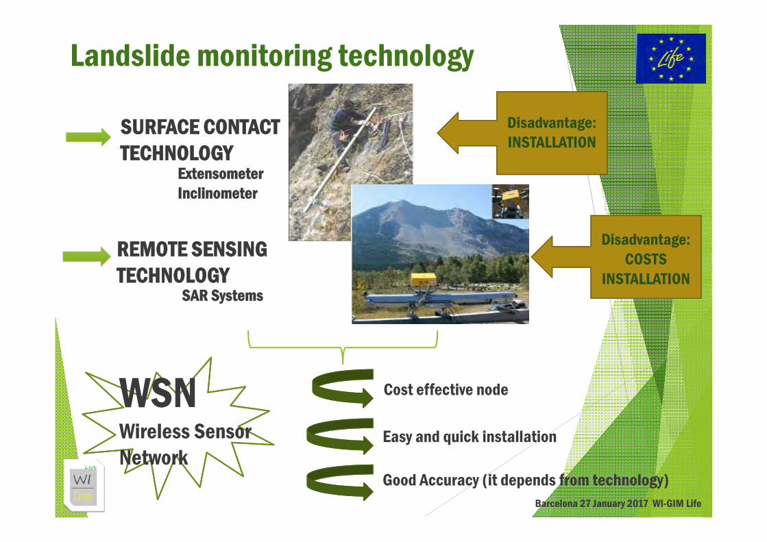
SURFACE CONTACT TECHNOLOGY
REMOTE SENSINGTECHNOLOGY
ExtensometerInclinometer
SAR Systems
Disadvantage: INSTALLATION
Landslide monitoring technology
WSNWireless Sensor Network
Cost effective node
Disadvantage: COSTS
INSTALLATION
Easy and quick installation
Good Accuracy (it depends from technology)Barcelona 27 January 2017 WI-GIM Life

WI-GIM Life major technology Innovation
WSN + RANGING RADIO
Wireless Sensor Network benefits+
Sensor node distance measurementwith radio frequency technology
Barcelona 27 January 2017 WI-GIM Life

WI-GIM Life: Ranging technology
Barcelona 27 January 2017 WI-GIM Life
HYBRID SOLUTIONUltra Wide Band
FMCW Radar
WI-Gim Node
GPS GSM
Ranging + Data Nodescommunication
Absolute positionData web access
Hi Precision Ranging
Barcelona 27 January 2017 WI-GIM Life
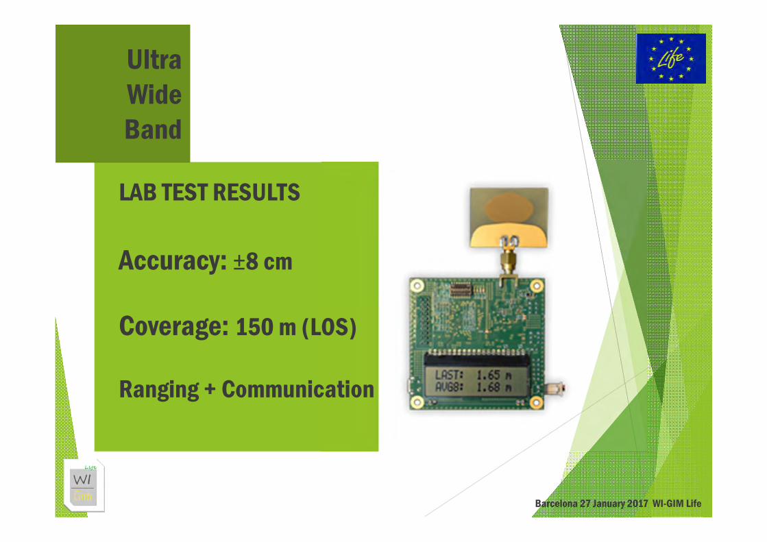
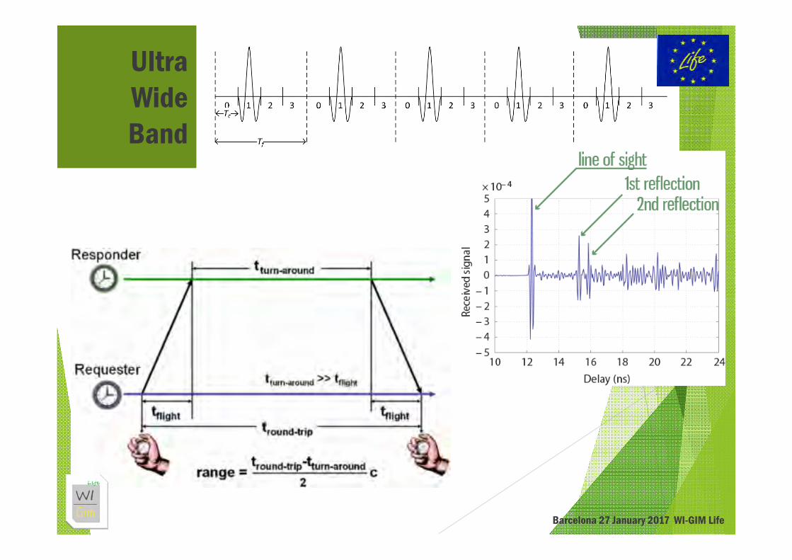
Ultra Wide Band
LAB TEST RESULTS
Accuracy: ±8 cm
Coverage: 150 m (LOS)
Ranging + Communication
Barcelona 27 January 2017 WI-GIM Life
Ultra Wide Band

Barcelona 27 January 2017 WI-GIM Life
FMCWRadar
LAB TEST RESULTS
Accuracy: ≈ 8 mm
Coverage: ≈ 70 m (LOS)It depends on the target surface area
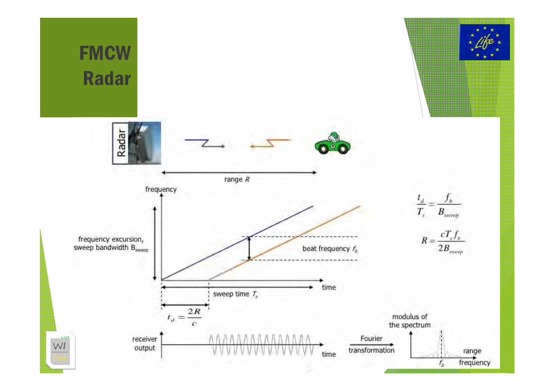
FMCWRadar
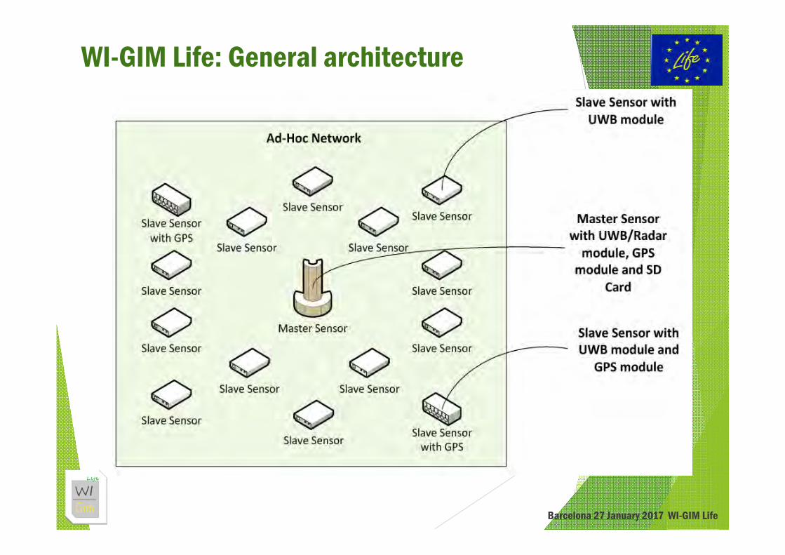
WI-GIM Life: General architecture
Barcelona 27 January 2017 WI-GIM Life
WI-GIM Life: Benefits of ad hoc networks
Barcelona 27 January 2017 WI-GIM Life
The architecture has been designed as an ad-hoc sensors network
Cluster-based Independent clusters Non-contiguous areas can be monitored at the same time More flexibility More scalability More adapt to future upgrades
No need for a “stable” area User-friendly configuration wizard Remote alarms Remote periodical report

WI-GIM Life: Project Idea
Barcelona 27 January 2017 WI-GIM Life

WI-GIM Life: Project Idea
Barcelona 27 January 2017 WI-GIM Life
Quick InstallationLow Cost
Flexibility
Real-TimeModularity
Low vulnerabilityLimited Environmental
Impact

WI-GIM Life: Prototype Development
Barcelona 27 January 2017 WI-GIM Life

WI-GIM Life: Prototype Testing
Barcelona 27 January 2017 WI-GIM Life

WI-GIM Life: Roncovetro ExperimentalSite
Barcelona 27 January 2017 WI-GIM Life

WI-GIM Life: SallentExperimentalSite
Barcelona 27 January 2017 WI-GIM Life
Master Node UWB
Master NodeRadar

WI-GIM Life: Technology
Barcelona 27 January 2017 WI-GIM Life
System Offsets- Compensation of Sensitivity of Decawave UWB algorithm
Outliers- Algorithms for identification and compensation of outliers have
been developed
Electronic noise depends on temperature- It has been compensated with data post-elaboration
Compact and resistant chassis- Atmospheric agent resistant (snow, rain, humidity)
System Power Consumption- Event-driven wake-up firmware algorithms have been developed
to perform energy saving on battery- Solar Cell add-on available
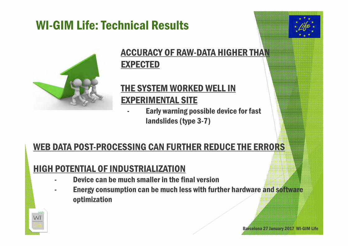
WI-GIM Life: Technical Results
Barcelona 27 January 2017 WI-GIM Life
ACCURACY OF RAW-DATA HIGHER THAN EXPECTED
THE SYSTEM WORKED WELL IN EXPERIMENTAL SITE
- Early warning possible device for fast landslides (type 3-7)
WEB DATA POST-PROCESSING CAN FURTHER REDUCE THE ERRORS
HIGH POTENTIAL OF INDUSTRIALIZATION- Device can be much smaller in the final version- Energy consumption can be much less with further hardware and software
optimization
THANK YOU FOR YOUR ATTENTION
http://www.life-wigim.eu WI-GIM Life EU Project WI-GIM Channel
Ing. Federico Trippi, Ph.D.Assistant Project [email protected]

WI-GIM Life: Wireless Sensor Network for Ground Instability Monitoring
The technology
Speaker: Ing. Federico Trippi, Ph.D.Junior Project Manager
WORKSHOP Monitorització del terreny com a eina de gestió del risc i presentació del Projecte Europeu Wi-GIMInstitut Cartogràfic i Geològic de CatalunyaBarcelona, 27 January 2017