Satellite-derived bathymetry: Overview and the demand of ...
10
Title: Speakers: Date: 7 & 8 December 2020 Organisers: Supported by: Satellite-derived bathymetry: Overview and the demand of guidelines in quality assurance Assoc. Prof. Dr. Poerbandono, ITB Bandung Dr. Thomas Heege, EOMAP Seefeld Captain Dr. Oke D. Pribadi, Pushidrosal Jakarta
Transcript of Satellite-derived bathymetry: Overview and the demand of ...

Title:
Speakers:
Date:
7 & 8 December 2020
Organisers: Supported by:
Satellite-derived bathymetry: Overview and the demand of guidelines in quality assurance
Assoc. Prof. Dr. Poerbandono, ITB Bandung Dr. Thomas Heege, EOMAP Seefeld
Captain Dr. Oke D. Pribadi, Pushidrosal Jakarta
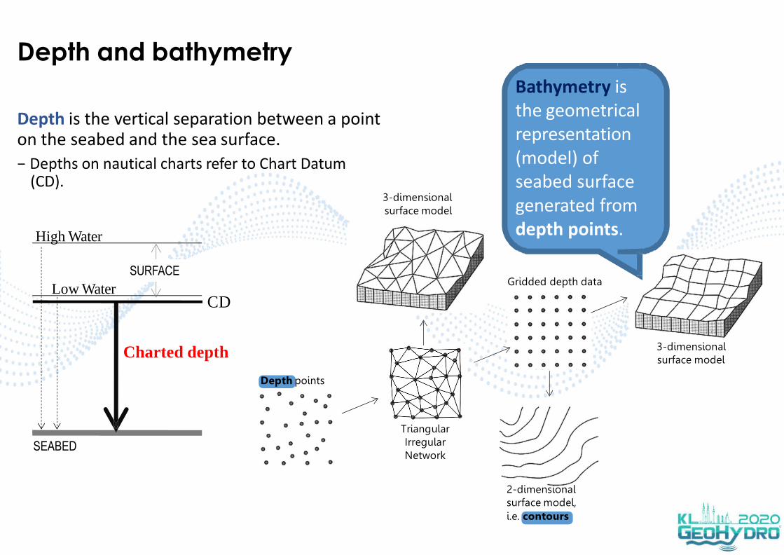
Depth and bathymetry
Charted depth
SEABED
Low WaterCD
Depth points
Triangular Irregular Network
Depth is the vertical separation between a point on the seabed and the sea surface.
− Depths on nautical charts refer to Chart Datum (CD).
3-dimensional surface model
High Water
Gridded depth data
2-dimensional surface model,i.e. contours
3-dimensional surface model
SURFACE
Bathymetry is the geometrical representation (model) of seabed surface generated from depth points.
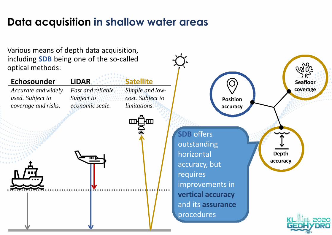
Data acquisition in shallow water areas
Various means of depth data acquisition,including SDB being one of the so-calledoptical methods:
Accurate and widely
used. Subject to
coverage and risks.
Fast and reliable.
Subject to
economic scale.
Echosounder LiDAR SatelliteSimple and low-
cost. Subject to
limitations.
Depth accuracy
Position accuracy
Seafloor coverage
SDB offers outstanding horizontal accuracy, but requires improvements in vertical accuracy and its assurance procedures

200
800
600
400
1000
0
2010 2011 2012 2013 2014 2015 2016 2017 2018 2019 2020
862
289314
143 144
Growth and trend
In Indonesia internet resources (i.e. news, exposure, event, research) regarding the application of SDB are growing.
− Imagery:
− Accuracy:
− Max. depths:
− Methods:
Sentinel 2A, Landsat 8, WorldView 2/3, Pleiades, SPOT
0.25 m to 6.27 m
2 m to 40 m
band-ratio, machine learning, physics-based
e.g. SBES
MSL, LWL, CD, N/A
0% or some 6% to 75%
− Calibration:
− Datum:
− Training data:
3
Common aspects in SDB
applications

0
1
2
3
4
5
6
7
0 10 40 50
4,56
0,65
6,27
1,071,77
0,510,54
Bel itung~1m
Claimed accuracy
Root-mean square errors (RMSE) is almost always used as measure of accuracy.− Use of TVU is also reported, i.e. % of compliance.
4
Semak Daun
Tj. Priok
1,91 Morotai
G. Iyang
~2.46m
G. Matra
M orot ai
G. Mat ra
Se mak Daun
Se mak Da un
Semak Da un
Tj. Priok
20 30Max. depth (m)
RM
SE(m
)
Range of RMSE
Sources: Dewi et al 2019, Jaelani & Putri 2019, Setiawan et al 2019, Meliala et al 2019, Muhammad et al 2020, Meliala et al 2020, Lumban-Gaol et al 2020, Dewi et al 2020

Application: Detection of shoalsChart Number 318 - South of Teluk Bone
Readings:− IHO B-11
(IHO-IOC GEBCOCook Book)
− IHO S-4
SDB has been useful to identify shoals.− Distinct presentation (of SDB origin) on chart is
required.
5
Depth Contour
Source: Pushidrosal
Imagery

Application: Shoals on chartsChart No. 373 Plan 3 - Pulau-pulau Takabonarate; Pulau-pulau Pasitelu
With SDB, chart is updated.
6
Before After
Source: Pushidrosal

Assuring quality: Satellite data
Correction of environmental impacts on satellite data→ Increasing data quality*
Levels of QA procedures*:
− Data evaluation - suitable imagery, reliable external QA/QC
− Data processing -
Simple: Band-ratios, regional calibration, machine learning
Advanced: Physical corrections on heterogeneous error sources
Integrated: Maximize degree of environmental corrections, highest independency and transparency, and highest data integration (i.e. multiple satellite imagery, external data assimilation and consistency check, error propagation and error forecast)
7*for all data points, also those without external data availability (majority of satellite data points)
products are subject of heterogeneous (error) sources: atmosphere, sea-state, turbidity, seafloor,
n , …
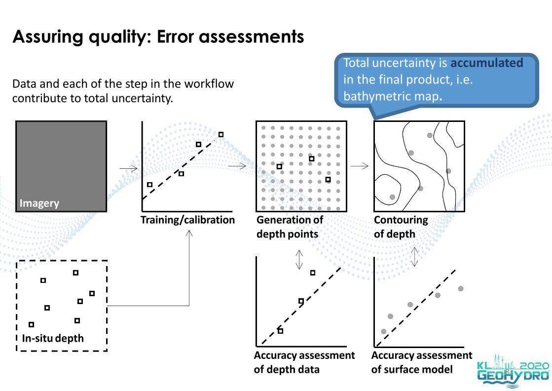
Accuracy assessment of depth data
Assuring quality: Error assessments
Data and each of the step in the workflow contribute to total uncertainty.
8
Imagery
In-situ depth
Training/calibration Generation of depth points
Contouring of depth
Accuracy assessment of surface model
Total uncertainty is accumulated in the final product, i.e. bathymetric map.

Closing remark
Uncertainties are contributed by:
− Satellite recording conditions
− Data analysis procedures
− In-situ depth data
− Data calibration/training
− Generation of depth points
− Generation of bathymetric contours
Concerns:
− Time of acquisition
− Vertical datum
− Tidal correction
− % and distribution of sample for training/calibration
− Correction level of environmental conditions: benthic cover, water column turbidity, …
− Integration level of data sources and data processing
9
Guidelines are required in assuring quality of SDB.