Oleschko Et Al. JAS 2000
10
Journal of Archaeological Science (2000) 27, 1007–1016 doi:10.1006/jasc.1999.0509, available online at http://www.idealibrary.com on Fractal Analysis of Teotihuacan, Mexico Klaudia Oleschko Instituto de Geologı ´a, UNAM, Apartado Postal 70-296, Circuito Exterior, Ciudad Universitaria, C.P. 04510, Coyoaca ´n, Me ´xico, D.F. Rosa Brambila Direccio ´n de Etnohistoria, INAH, Paseo de la Reforma y Calzada Gandhi, Chapultepec, C.P. 11560, Me ´xico, D.F. Fernando Brambila Facultad de Ciencias, Departamento de Matema ´ticas, UNAM, Apartado Postal 70-296, Circuito Exterior, Ciudad Universitaria, C.P. 04510, Coyoaca ´n, Me ´xico, D.F. Jean-Francois Parrot Universite ´ Pierre et Marie Curie, De ´partement de Ge ´otectonique, L.G. G. S. T., Boite 129 T 26/16, 1 et 4, place Jussieu, 75252, Paris cedex 05, France Pedro Lo ´ pez Escuela Nacional de Antropologı ´a e Historı ´a, Me ´xico, D.F. (Received 18 September 1998, revised manuscript accepted 1 November 1999) The standardisation in architectural orientation and construction forms, as well as the symmetric and highly proportional spatial distribution of buildings, suggest that the major structures of Teotihuacan were laid out from its inception according to a master plan (or plans) intended to express a specific worldview in material form. Fractal analysis of the Teotihuacan radar image and aerial photographs has confirmed that a master plan does exist in this archaeological area. The Sierpinski carpet, one of the best known deterministic fractal models, is proposed as the model for Teotihuacan in two-dimensional Euclidean space. Its dimension (1·89) is also proposed as the basic unit which joins in space the Mesoamerican calendar and the buildings’ geometrical measures. It is hypothesised that inside the master plan of Teotihuacan, the information pertaining to space is expressed across the two-dimensional planes, and that of time through the pyramid verticals. A value of 0·83 m, which corroborates with the Teotihuacan measurement unit (TMU) proposed by different anthropologists, was derived from an analysis of the height of the Sun and Moon Pyramids. These results open new prospects for future comparisons between different settlements and monuments, that were supposedly constructed by the people from Teotihuacan. 2000 Academic Press Keywords: TEOTIHUACAN MASTER PLAN, SIERPINSKI CARPET, MEASUREMENT UNIT. Introduction T he Teotihuacan archaeological zone is 50 km northeast of Mexico City. Its history began 100 and finished about 700. This period has been divided into four stages, and it is recog- nised that it was at its height in 300, when the constructions occupied an area of 22 square kilometres. The extent of the influence of this civilis- ation expanded to the state of Zacatecas (Mexico) in the north, and to Guatemala in the south (Kubler, 1962; Lo ´ pez Austin, 1998). A mathematical analysis 1007 0305–4403/00/111017+10 $35.00/0 2000 Academic Press
-
Upload
mijaely-castanon -
Category
Documents
-
view
24 -
download
0
Transcript of Oleschko Et Al. JAS 2000
Journal of Archaeological Science (2000) 27, 1007–1016doi:10.1006/jasc.1999.0509, available online at http://www.idealibrary.com on
Fractal Analysis of Teotihuacan, Mexico
Klaudia Oleschko
Instituto de Geologıa, UNAM, Apartado Postal 70-296, Circuito Exterior, Ciudad Universitaria, C.P. 04510,Coyoacan, Mexico, D.F.
Rosa Brambila
Direccion de Etnohistoria, INAH, Paseo de la Reforma y Calzada Gandhi, Chapultepec, C.P. 11560,Mexico, D.F.
Fernando Brambila
Facultad de Ciencias, Departamento de Matematicas, UNAM, Apartado Postal 70-296, Circuito Exterior,Ciudad Universitaria, C.P. 04510, Coyoacan, Mexico, D.F.
Jean-Francois Parrot
Universite Pierre et Marie Curie, Departement de Geotectonique, L.G. G. S. T., Boite 129 T 26/16,1 et 4, place Jussieu, 75252, Paris cedex 05, France
Pedro Lopez
Escuela Nacional de Antropologıa e Historıa, Mexico, D.F.
(Received 18 September 1998, revised manuscript accepted 1 November 1999)
The standardisation in architectural orientation and construction forms, as well as the symmetric and highlyproportional spatial distribution of buildings, suggest that the major structures of Teotihuacan were laid out from itsinception according to a master plan (or plans) intended to express a specific worldview in material form. Fractalanalysis of the Teotihuacan radar image and aerial photographs has confirmed that a master plan does exist in thisarchaeological area. The Sierpinski carpet, one of the best known deterministic fractal models, is proposed as the modelfor Teotihuacan in two-dimensional Euclidean space. Its dimension (1·89) is also proposed as the basic unit which joinsin space the Mesoamerican calendar and the buildings’ geometrical measures. It is hypothesised that inside the masterplan of Teotihuacan, the information pertaining to space is expressed across the two-dimensional planes, and that oftime through the pyramid verticals. A value of 0·83 m, which corroborates with the Teotihuacan measurement unit(TMU) proposed by different anthropologists, was derived from an analysis of the height of the Sun and MoonPyramids. These results open new prospects for future comparisons between different settlements and monuments, thatwere supposedly constructed by the people from Teotihuacan. � 2000 Academic Press
Keywords: TEOTIHUACAN MASTER PLAN, SIERPINSKI CARPET, MEASUREMENT UNIT.
Introduction
T he Teotihuacan archaeological zone is 50 kmnortheast of Mexico City. Its history began100 and finished about 700. This period
has been divided into four stages, and it is recog-
10070305–4403/00/111017+10 $35.00/0
nised that it was at its height in 300, when theconstructions occupied an area of 22 squarekilometres. The extent of the influence of this civilis-ation expanded to the state of Zacatecas (Mexico) inthe north, and to Guatemala in the south (Kubler,1962; Lopez Austin, 1998). A mathematical analysis
� 2000 Academic Press
1008 K. Oleschko et al.
was applied broadly to Teotihuacan in order todescribe the complexity of its society and culture. Itwas shown that geometrical knowledge was used sys-tematically by the ancients during multiple activities,especially for the design of buildings and architectoniccomplexes, and for the planning of the generalsettlement (Mora, 1984). Harlestone (1974) has madea detailed mathematical analysis of Teotihuacan,reaching the conclusion that its general design is anintegrated display of mathematical and geodetic infor-mation. This researcher has mentioned that ‘‘thecontribution of Teotihuacan to archaeology andanthropology can hardly be overestimated. Its mes-sages may be recognized as originated from a monu-mental complex of the highest intuitive order yet to befound, and as an intellectual resource of first rank inthe future of humanity’’.
The importance of searching for the measurementunit used for construction at Teotihuacan has beenoutlined by different anthropologists (Harleston, 1974;Sugiyama, 1993). The standardisation in architecturalorientation and construction forms, and the symmetricand highly proportional spatial distribution of build-ings, suggest that the major structures of Teotihuacanwere laid out from its inception according to a masterplan (or plans) intended to express a specific worldviewin material form. Various anthropologists (Almaraz,1865; Drucker, 1974; Drewitt, 1987; Harleston, 1974;Sugiyama, 1993) suggested the use of a standardisedmeasurement unit or units in the city master plan.Nevertheless, Sugiyama (1993) has mentioned thatall these searches for the measurement unit havenot reached a consensus because of the complexitiesof architectural units and superimposed modifi-cations that covered or destroyed original plans. Healso supposed that ‘‘the fact that we do not know howand which part of construction Teotihuacanosmeasured, has been an obstacle for systematic studies’’(Sugiyama, 1993).
Different measurement units for the majorTeotihuacan monuments and for the Ciudadela andGreat Compound have been proposed by researchers.Harleston (1974), based on the detailed measurementof Teotihuacan constructions, has estimated the aver-age metric unit of 1·059463 m, and called it ‘‘hunab’’,which means ‘‘the unified measurement unit’’. Thisresearcher also concludes that all measures of the mainTeotihuacan monuments and buildings are convertedto proportional multiples of thirds and sixths, and lessfrequently to sevenths and tenths.
In the work discussed above, simple geometricalmeasurements were applied in order to obtain theoriginal Teotihuacan measurement unit (TMU;Sugiyama, 1993) directly from the two-dimensionalschematic representation of the constructions. Never-theless, from the outset it was supposed that the peopleof Teotihuacan derived the TMU from the mostcharacteristic feature of the Mesoamerican beliefsystem: the space and time intimate relation and
combination (Kirchhoft, 1943; Kubler, 1962; Leon-Portilla, 1963; Coe, 1981). However, at present it is notclear at all how this combination was achieved, andhow the people of Teotihuacan measured time. It ispossible that the TMU analysis requires the use ofsome special analytical technique, able to reveal thisspatial and time combination. Fractal geometry seemsto fulfil this requirement. Rodrıguez et al. (1995) calledfractals ‘‘a new language for archaeology’’, and haveused this technique for the analysis of the informationnetworks and their relationship, implying that infor-mation exchange follows a fractal structure. As anexample, they tackle the problem of the expansion ofdomestic species in the Mediterranean basin, propos-ing an alternative fractal model. However, at present,fractal analysis is not a common tool in archaeologicalresearch.
The principal objectives of this study are to usefractal geometry to: (1) find some geometrical evidenceof the Teotihuacan master plan; (2) detect the nature ofthe most common multiples used in Teotihuacan; (3)confirm the existence of a unique measurement unitused during the design of this archaeological complex.To meet these objectives we analysed digital images ofTeotihuacan, taken by different sensors and at differingspatial and spectral resolution.
The main hypotheses of this work are: (1) thatfractal analysis is capable of revealing that a space/timecombination exists in the Teotihuacan master plan;(2) in the master plan of Teotihuacan, the informationpertaining to space is expressed across the horizontalplane and that pertaining to time is expressed along thepyramid verticals.
Materials and Methods
Source dataRadar image. The grey level image we analysed is theexabyte Synthetic Aperture Radar (SAR.PRI) pro-grammed image, obtained by the Norman station ofESA, on 28 December 1995. The resulting scenecorresponded to orbit 23,289, and frame 3213, withfour corner coordinates: latitude 19�11�, longitude99�27�; latitude 20�04�, longitude 99�15�; latitude 19�53�,longitude 98�20�; latitude 19�00�, longitude 98�32�. Thesatellite trajectory was close to the north–south direc-tion over the Teotihuacan zone and perpendicular tothe main orientation of streets and buildings (east–west), thereby ensuring the optimum quality of theradar image of most monuments due to the maximumreflection. Teotihuacan occupies the central portionof the image. The fractal analysis of the GreatCompound, Ciudadela, ‘‘Avenue of the Dead’’ and theSun Pyramid, extracted from raw and filtered SARimages, was carried out. All other major monumentswere beyond the resolution of the radar. The adaptedversion of the HK-Filter (Parrot & Taud, 1995) wasused for image filtering.
Fractal Analysis of Teotihuacan, Mexico 1009
Aerial photographs. Black and white aerial photo-graphs of the studied area were taken in 1962 with twodifferent resolutions, corresponding to scales of1:30,000 and 1:5000. All photographs include theTeotihuacan city, modern buildings, agricultural fieldsand roads. All elements were analysed separately(Table 1). The Great Compound, Ciudadela, Sun,Moon and Quetzalcoatl Pyramids, and Palace ofQuetzalpapalotl were extracted from each aerialphotograph.
Fractal geometry. A family of shapes with irregular andfragmented patterns was called fractals by Mandelbrot(1983). Fractal geometry has become a scientific disci-pline in its own right and has had a great impact ondifferent fields of science, technology and art (Voss &Wyatt, 1993). The most common fractals tend to bescale independent, implying that the degree of theirirregularity and/or fragmentation is identical at allscales. If these parameters are the same in all directions(i.e. isotropic), the fractal set is called self-similar. Theconcept of self-similarity recognises that a small part ofa shape mimics the characteristics of the whole. Whena shape is described as consisting of N subshapes, eachscaled down by a factor r<1 from the original, it ischaracterised by a fractal dimension, D, where
D=log(N)/log(1/r)
The fractal dimension is the central conceptof fractal geometry. Many applications of fractal
modelling rely on the ability to accurately estimate theobject’s fractal dimension from images (Mandelbrot,1983). The dimensionality of self-similar fractals isestimated by the traditional box-counting tech-nique, filling the set with progressively larger boxes.The box dimension has been variously termed:Hausdorff–Besicovich dimension, similarity dimen-sion, Kolmogorov entropy, entropy dimension,capacity dimension etc. (Falconer, 1990).
The mass fractal dimension (Dm) is the most com-mon example of the empirical box dimension, speciallysuited to describe the heterogeneity and space-fillingability of the fractal set. For a mass fractal, the ‘‘mass’’of an object (M) increases with a characteristic radius(r) according to the power law
M�rDm,
where the exponent Dm is always less than theembedding dimension E of the Euclidean space RE
(Anderson et al., 1998). The mass fractal dimensionseems to be specially suited to describe town-planningand in general the urbanisation design, because itestimates the efficiency of space occupation. Someother fractal parameters, for instance the spectraldimension (or fracton), are useful as quantitative indi-cators of the connectivity among all constructions, orroad sinuosity (tortuosity).
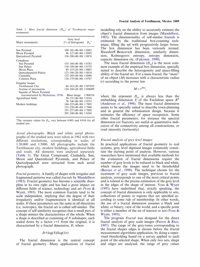
Table 1. Mass fractal dimension (Dm) of Teotihuacan majormonuments
Major monumentsGrey level
(% of histogram) Dm1
Sun Pyramid 100–241 (40–80) 1·8882Moon Pyramid 96–127 (40–80) 1·8993Quetzalcoatl Pyramid 136–208 (40–80) 1·8876
ComplexesSun Pyramid 153–186 (40–80) 1·8765Sun Palace 154–188 (40–80) 1·8755Moon Plaza 89–153 (20–80) 1·8883Quetzalpapalotl Palace 123–186 (20–80) 1·8816Ciudadela 152–189 (40–80) 1·8880Columns Plaza 124–179 (40–80) 1·8767
Irregular imagesTeotihuacan City 68–163 (20–40) 1·897835Avenue of processions 124–168 (20–80) 1·896089Squeme of Moon Pyramid
(reconstructed by Harlestone, 1974) Binar image 1·904316Agricultural fields 50–131 (40–80) 1·9516
58–146 (40–80) 1·9553Modern buildings 164–225 (40–80) 1·7805
123–226 (40–80) 1·7940191–237 (40–80) 1·7888205–240 (40–80) 1·8243
1The variance values for Dm vary between 0·003 and 0·016 for allstudied sets.
Fractal analysis of grey level imagesIn practical applications of fractal geometry to realsystems, grey level digitised images commonly consti-tute the starting point of analysis. However, variousresearchers have mentioned that available methods forthe evaluation of fractal dimensions require thenumber of grey levels to be reduced to black and white,which means the images need to be thresholded(Baveye et al., 1998). The technique chosen for thetreatment of grey scale images, previous to fractalanalysis, corresponds to one of the most critical pointsand is related to the precise estimation of the grey levelin the edges of the shape of interest. Voss & Wyatt(1993) have underlined that, strictly speaking, theconcept of fractal dimension is only applicable to sets,collections of points or regions that are specified ac-cording to some rule of membership. In other words,the use of a fractal dimension assumes a black andwhite, or binary, view of the world, and a specific pointis either a member of the set of interest or not (Voss &Wyatt, 1993).
The program Fractal was designed for the directfractal analysis of grey scale images (Parrot & Rico,1997). The range of the grey-tones corresponding tothe fractal shapes edges is chosen before the fractalmeasurement algorithms application, by doing a super-vised thresholding based on a survey applied to eachpoint of the selected shape. When only two sets, shapeand edges are analysed, the range of grey values
1010 K. Oleschko et al.
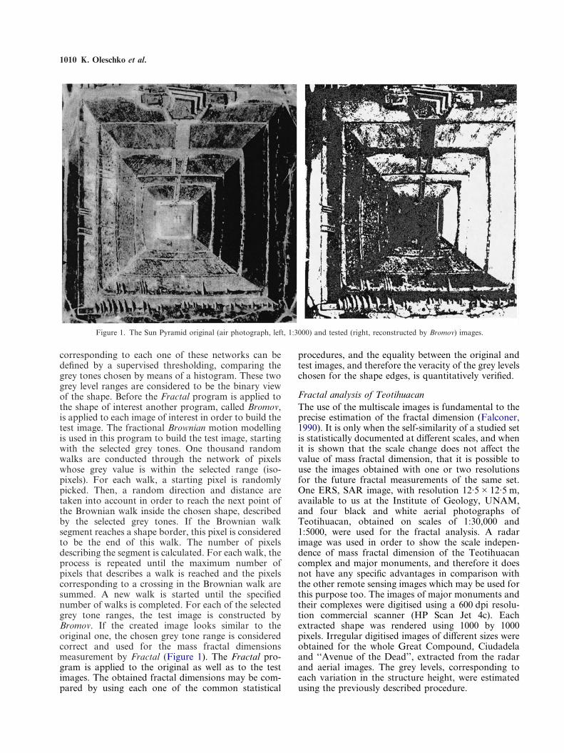
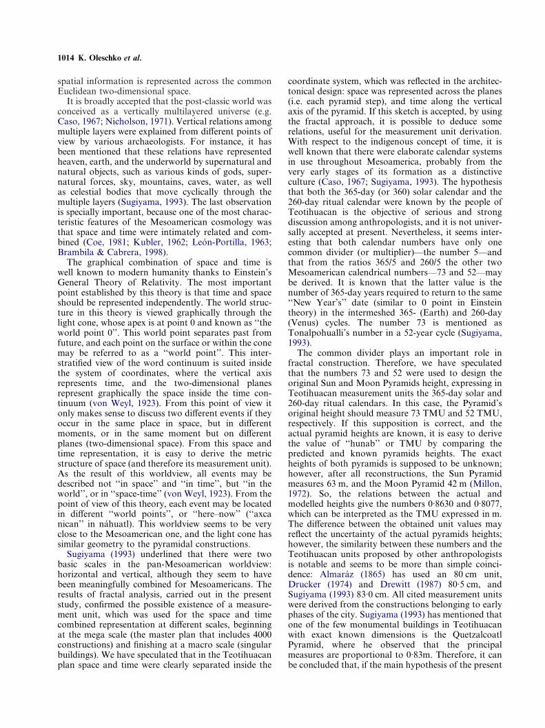
corresponding to each one of these networks can bedefined by a supervised thresholding, comparing thegrey tones chosen by means of a histogram. These twogrey level ranges are considered to be the binary viewof the shape. Before the Fractal program is applied tothe shape of interest another program, called Bromov,is applied to each image of interest in order to build thetest image. The fractional Brownian motion modellingis used in this program to build the test image, startingwith the selected grey tones. One thousand randomwalks are conducted through the network of pixelswhose grey value is within the selected range (iso-pixels). For each walk, a starting pixel is randomlypicked. Then, a random direction and distance aretaken into account in order to reach the next point ofthe Brownian walk inside the chosen shape, describedby the selected grey tones. If the Brownian walksegment reaches a shape border, this pixel is consideredto be the end of this walk. The number of pixelsdescribing the segment is calculated. For each walk, theprocess is repeated until the maximum number ofpixels that describes a walk is reached and the pixelscorresponding to a crossing in the Brownian walk aresummed. A new walk is started until the specifiednumber of walks is completed. For each of the selectedgrey tone ranges, the test image is constructed byBromov. If the created image looks similar to theoriginal one, the chosen grey tone range is consideredcorrect and used for the mass fractal dimensionsmeasurement by Fractal (Figure 1). The Fractal pro-gram is applied to the original as well as to the testimages. The obtained fractal dimensions may be com-pared by using each one of the common statistical
procedures, and the equality between the original andtest images, and therefore the veracity of the grey levelschosen for the shape edges, is quantitatively verified.
Figure 1. The Sun Pyramid original (air photograph, left, 1:3000) and tested (right, reconstructed by Bromov) images.
Fractal analysis of TeotihuacanThe use of the multiscale images is fundamental to theprecise estimation of the fractal dimension (Falconer,1990). It is only when the self-similarity of a studied setis statistically documented at different scales, and whenit is shown that the scale change does not affect thevalue of mass fractal dimension, that it is possible touse the images obtained with one or two resolutionsfor the future fractal measurements of the same set.One ERS, SAR image, with resolution 12·5�12·5 m,available to us at the Institute of Geology, UNAM,and four black and white aerial photographs ofTeotihuacan, obtained on scales of 1:30,000 and1:5000, were used for the fractal analysis. A radarimage was used in order to show the scale indepen-dence of mass fractal dimension of the Teotihuacancomplex and major monuments, and therefore it doesnot have any specific advantages in comparison withthe other remote sensing images which may be used forthis purpose too. The images of major monuments andtheir complexes were digitised using a 600 dpi resolu-tion commercial scanner (HP Scan Jet 4c). Eachextracted shape was rendered using 1000 by 1000pixels. Irregular digitised images of different sizes wereobtained for the whole Great Compound, Ciudadelaand ‘‘Avenue of the Dead’’, extracted from the radarand aerial images. The grey levels, corresponding toeach variation in the structure height, were estimatedusing the previously described procedure.
Fractal Analysis of Teotihuacan, Mexico 1011
The Fractal program, designed by Parrot & Rico(1997) and written using environment Borland C + +language, was used for the bidimensional fractal analy-sis of the grey scale images. This program is based onthe traditional box-counting technique. The estimateddimension (Dm) is the mass fractal dimension of theobject embedded in the Euclidean space, and is simi-lar to the ‘‘box’’ or ‘‘capacity’’ fractal dimension(Oleschko et al., 1997, 1998).
The fractal dimensions of all Teotihuacan structuresof interest were estimated by covering the object (or thecomplex of objects) with boxes of progressively largersizes. The box size was equal to �-pixels, where � is theresolution of the method applied. For regular imagesthe �-size ranges from 1 to the maximum pixel size of1000. Therefore, 16 different boxes were used for thedimension estimation on each one of the images,obtained with three different resolutions. This boxnumber ensures 16 points on each experimental plot,sufficient for the statistically strong adjustment to thetheoretically expected stright line (Huang et al., 1994).For irregular images, the maximum pixel numberdepends on the exact image size. In both cases, thenumber of �-pixels or boxes that cover the objectof interest was counted for increasing �. Thismethod, used for two-dimensional image analysis, wasdescribed and shown diagrammatically by Andersonet al. (1998), who mentioned that the value of Dm canbe estimated from a plot of ln (number of filled�-pixels) versus ln(�). A straight line was fitted to theobtained data by least-squares regression and Dm wasestimated from the negative of the slope. Differentresearchers have shown that, from a methodologicalpoint of view, the value of the regression coefficient ofdetermination is the best indicator of the fractal natureof the studied object, and the character of the plot(the way it approaches the straight line) facilitates thevisual estimation of how far from the ideal fractal theanalysed set is (Huang et al, 1994). From the begin-ning, it was assumed that the values of Dm should bebetween 1 and 2, since 1 and 2 would be expected fora completely filled line and rectangle, respectively(Anderson et al., 1998).
Results and Discussion
Search for the Teotihuacan master planDifferent anthropologists, including Sugiyama (1993),have underlined that Mesoamerican societies seem tohave explicitly expressed ritual meanings, cosmology,worldviews, legendary history, and calendar systems inmaterial culture. The results of different researchprojects, carried out during the 1970s, have disclosedthe existence of numerous features of an urban planin Teotihuacan (Bernal, 1964; Millon, 1973, 1981;Sanders et al., 1979; Sanders, 1981; Brambila, 1982),and have also changed the old view of Teotihuacanas a ceremonial centre exclusively, to one where the
city is considered as an ancient urban centre. Never-theless, there is general consensus that the people ofTeotihuacan perhaps never used the technology ofprecision during city planning. Apart from the majorreligious monuments, 4000 construction units werediscovered inside the Teotihuacan complex, related tothe different social functions (from residence to work-shop), but architectonically linked (Manzanilla, 1996;Morelos, 1998). Furthermore, some of these con-structions have similar pyramidal bases. At present,all information used to describe the Teotihuacanterritorial organisation comes from aerial photos,direct field work and excavations. The studies haverevealed that some streets and most of the buildingswere distributed harmonically and symmetrically withrespect to two perpendicular principal axes, whichintersect near the Ciudadela and Great Compound anddivide the town into quadrants. This layout is typicalfor all towns of Central Mexico. Millon (1967) hasproposed the Quetzalcoatl Temple as the central pointof both axes. It was observed that the orientation ofstreets and buildings, distributed at a fixed distancefrom one another, was east–west and that, in general,town growth follows this master plan. Notwithstand-ing, some archaeologists disagree with this hypothesis,supporting the idea of empirical urbanism inTeotihuacan (Castillo & Arana, 1987). However, thereis a general consensus that the architectural features ofall buildings show a similar pattern, and the edificationvolume was designed in agreement with the landscape.Finally, it seems possible to state that the Teotihuacanterritorial structure has specific order in space, which isrelated to the Mesoamerican cosmovision, expressedby the construction orientation and also the possibleuse of a measurement unit. Dow (1967), Drucker(1977), Malmstrom (1978), Aveni (1980), Sugiyma(1993), Angulo (1997) and Ruiz et al. (1998), have allsuggested that the monument edification was guided bythe stellar movement. Sugiyama (1993) has concludedthat a master plan showing the sketch of the universeexisted since the beginning of the city’s configuration.
From the beginning, the Teotihuacan GreatCompound, consisting of 4000 constructions, wasanalysed using the SAR raw and filtered images (megascale). Then the Ciudadela, and the Sun and MoonPyramids were extracted from these images, and ana-lysed individually. The mass fractal dimension (Dm) ofthe Teotihuacan Great Compound was surprisinglyclose to the dimension of each analysed pyramid andmonument. For all these objects Dm was near to 1·89.The fractal analysis of the same structures wasrepeated by using the aerial photographs of differentresolution and with several orientations. The othersmaller Teotihuacan monuments were extracted onlyfrom the aerial photographs. Nevertheless, the sameclear tendency to the constant and similar value ofmass fractal dimension (near to 1·89) was observed inthese structures too, including the Moon Pyramid, thePalace of Quetzalpapalotl, the Avenue of the Dead,
1012 K. Oleschko et al.
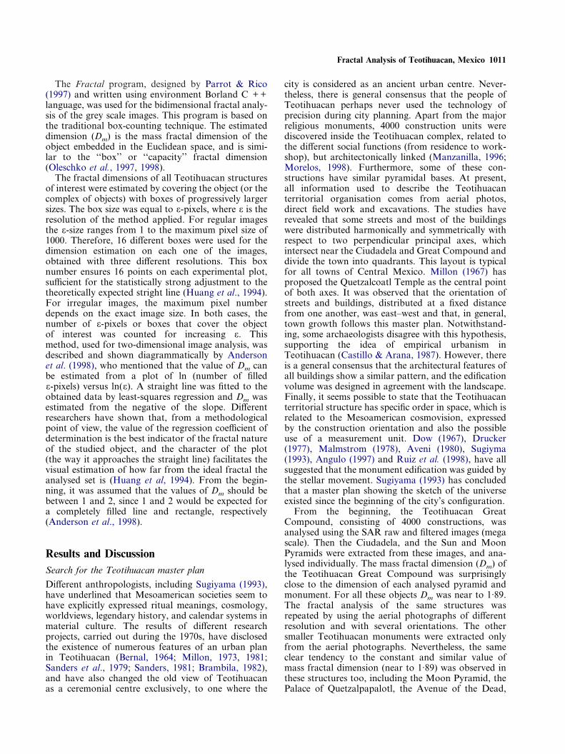
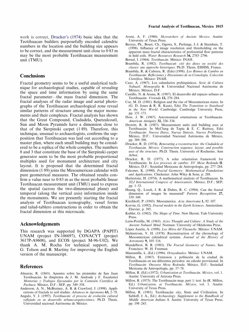
Figure 2. ‘‘Negative’’ of Sierpinski’s carpet (a) and air photographsof Ciudadela (b) 1:5000.
and the Quetzalcoatl Pyramid. The results were inde-pendent on the image nature, resolution and orien-tation. The mass fractal dimensions of all analysedstructures and complexes are presented in Table 1. Toconfirm these results, the binary image of the MoonPyramid plan, theoretically reconstructed by Harleston(1974), was digitised and used for the fractal analysis.The mass fractal dimension of 1·89 was also obtainedfor this plan. The value of 1·89 corresponds to one ofthe best known deterministic fractals: Sierpinskicarpet. Therefore, the strong statistical similarity wasdocumented for the geometry of all major monumentsand their complexes, and the structure of the Sierpinskicarpet (Figure 2). The data variance ranged between0·003 and 0·016.
The triadic Sierpinski carpet is known as the1<D<2-dimensional analogue of the Cantor set inthe bidimensional Euclidean space (Korvin, 1992). Itsdimension is D=log8/log3=1·8928. This fractalis self-similar, and it is constructed in an iterativemanner, similar to Cantor’s dust and Menger’s sponge.The fractal construction starts out from an initiator,which may be a simple polygon, the unit interval orbroken line consisting of straight line segments of equalsize. The application of the generator consists of thereplacement of the initiator by a scaled-down versionof the generator. In the Sierpinski (1916) carpet, theinitiator is a filled square of Euclidean dimension (E)and linear size (L), which can be divided into (n) equalsmaller replicates of linear size (rL). The similarityratio for this fractal is: r=1/3, and is defined byfollowing the general rule: nrE=1 (Rieu & Perrier,1998). The Sierpinski carpet is initiated on a squarewith E=2, L=1, and n=9, discarding the centralsquare of side 1/3. N=8 parts of n=r-E are retained ateach repetition. This carpet’s area vanishes, while thetotal perimeter of its holes is infinite (Mandelbrot,1983). Mandelbrot (1983) has mentioned that thedimension of the carpet (1·8928) expresses the frag-mentation degree of land into islands, rather than theirregularity degree of the island coastline. A clearvisual similarity exists between the bidimensionalimages of the Teotihuacan Pyramids and the ‘‘nega-tive’’ of the Sierpinski carpet (Figure 2). The arrange-ment in space of Teotihuacan’s constructions gives afractal dimension close to that of the Sierpinski carpet.
The results discussed above corroborate the previoussupposition that Teotihuacan was laid out according toa multiscale master plan, where each small construc-tion tends to repeat the general structure of the GreatCompound. This plan is clearly revealed by fractalanalysis, in spite of the fact that the city layout wasaccomplished during different phases and that mostbuildings underwent several remodelling events. In thiscase, the numbers 8 and 3 that constitute the base ofSierpinski carpet generator can be proposed as themost probable proportional multiples used for themonument architecture and city layout. Harlestone(1974) has accomplished the direct geometrical
measurements of the city plan and has shown that,aside from the errors related to the reconstruction, it ispossible to ensure that all systems were organisedaround the number 3. However, the next question maybe asked: was the Teotihuacan original master plantwo- or three-dimensional? All measurements carriedout in the course of this study were on the two-dimensional images of three-dimensional objects.Dimensional equivalents of spatial objects and theirprojected images are well identified in stereology;
Fractal Analysis of Teotihuacan, Mexico 1013
however, these equivalents are still poorly defined inapplied fractal analysis. If, instead of the two-dimensional Sierpinski carpet, a three-dimensionalfractal construction of pyramidal shape is chosen, thefollowing observations seem to be valid. A fractalknown by the name ‘‘skewed web of Mandelbrot’’(1983, Plate 143) is visually similar to each pyramidalconstruction. This web with dimension D=2 obtainsrecursively, with N=4 and r=1/2, using a closed tetra-hedron as initiator and a collection of tetrahedrons asgenerator. The web projects on the initial square andsubsquares boundaries overlap. Clear visual differ-ences exist between this fractal projection and theTeotihuacan aerial photographs. From this obser-vation the following hypothesis was derived: the two-dimensional plane was used in the Teotihuacan masterplan to express the space information, while thethird dimension was used for another specific purpose,probably for time representation.
For comparison, the fractal analysis of modernbuildings and images of agricultural fields, close tothe archaeological zone, was carried out. Clear andstatistically strong differences were observed betweenthe fractal dimensions of these buildings and fields andthe Teotihuacan complexes. The mean fractal dimen-sion for the modern building ranged between 1·78 and1·82, and for the agricultural fields between 1·95 and1·96 (Table 1).
In future research, it will be interesting to compareall discussed results with the fractal analysis ofTeotihuacan iconography, vessel forms and talud-tablero constructions, in order to obtain the fractaldimensions at a microscale. The application of fractalanalysis to the classification of the early Chinese land-scape paintings suggests that the fractal dimensionprovides the best agreement with the human eye forhighlighting and discriminating between images (Voss& Wyatt, 1993).
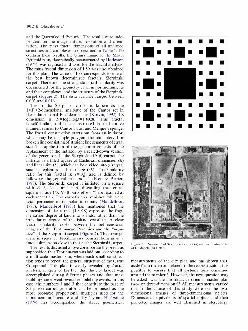
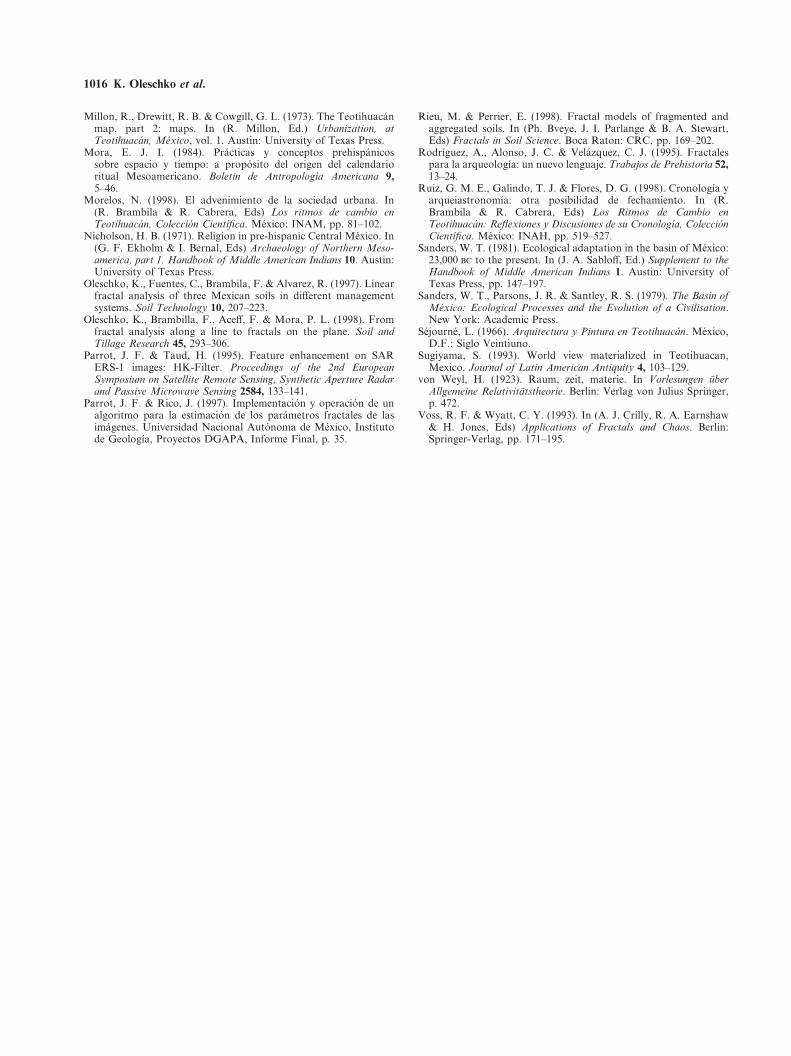
Figure 3. Moon Pyramid square (air photograph, 1:3000).
Teotihuacan measurement unit (TMU)Different researchers have established that the Meso-american societies had a pattern of measurement. Forthese societies the most familiar measurement system isrelated to time, where the calendar represents thestructured time. Sugiyama (1993), on the basis ofevidence from the study of Teotihuacan architecturalplan, has derived the measurement unit that is close to83 cm. He establishes that this unit reveals Meso-american calendarical numbers as 52 (�10), 73, 260,584, and 819, when applied to city axes and majormonuments.
Several measurement units have been proposed forthe pattern of Teotihuacan space. However, someresearchers insist that no single unit exists in thisarchaeological complex, because different measure-ment units were used in different locations within thecity, and they might have changed with time. Almaraz(1865) proposed 80 cm as the measurement unit of
Teotihuacan, while Drewitt (1987) and Drucker (1974)have estimated 80·5 cm, Sejourne (1966) 60 m, andDrewitt has claimed 57 m and 322 m as larger units(80·5 cm�400). The measurement unit of 1·059m wasproposed by Harleston (1974). This unit was derivedfrom the number 57, dividing it by two multiplierscommon for Teotihuacan: three and six (Harleston,1974). The value 57 was suggested by Million et al.(1973) as the measurement unit, because the principalTeotihuacan constructions exhibit multiples of 57 m.Sugiyama (1993) has underlined that the question ofhow to verify each one of the proposed units hasremained unresolved.
From our point of view, the basic question that mustbe answered before the TMU analysis is realisedshould be: did the people of Teotihuacan represent therelation and combination between space and time? Ifthe answer is yes, how did they do that? It is wellknown that in Mesoamerican iconography the treerepresents the great cosmos and time may be readfrom it in a linear manner. From this fact, it maybe suspected that temporal information is related tothe vertical axis of major monuments, while all
1014 K. Oleschko et al.
spatial information is represented across the commonEuclidean two-dimensional space.
It is broadly accepted that the post-classic world wasconceived as a vertically multilayered universe (e.g.Caso, 1967; Nicholson, 1971). Vertical relations amongmultiple layers were explained from different points ofview by various archaeologists. For instance, it hasbeen mentioned that these relations have representedheaven, earth, and the underworld by supernatural andnatural objects, such as various kinds of gods, super-natural forces, sky, mountains, caves, water, as wellas celestial bodies that move cyclically through themultiple layers (Sugiyama, 1993). The last observationis specially important, because one of the most charac-teristic features of the Mesoamerican cosmology wasthat space and time were intimately related and com-bined (Coe, 1981; Kubler, 1962; Leon-Portilla, 1963;Brambila & Cabrera, 1998).
The graphical combination of space and time iswell known to modern humanity thanks to Einstein’sGeneral Theory of Relativity. The most importantpoint established by this theory is that time and spaceshould be represented independently. The world struc-ture in this theory is viewed graphically through thelight cone, whose apex is at point 0 and known as ‘‘theworld point 0’’. This world point separates past fromfuture, and each point on the surface or within the conemay be referred to as a ‘‘world point’’. This inter-stratified view of the word continuum is suited insidethe system of coordinates, where the vertical axisrepresents time, and the two-dimensional planesrepresent graphically the space inside the time con-tinuum (von Weyl, 1923). From this point of view itonly makes sense to discuss two different events if theyoccur in the same place in space, but in differentmoments, or in the same moment but on differentplanes (two-dimensional space). From this space andtime representation, it is easy to derive the metricstructure of space (and therefore its measurement unit).As the result of this worldview, all events may bedescribed not ‘‘in space’’ and ‘‘in time’’, but ‘‘in theworld’’, or in ‘‘space-time’’ (von Weyl, 1923). From thepoint of view of this theory, each event may be locatedin different ‘‘world points’’, or ‘‘here–now’’ (‘‘axcanican’’ in nahuatl). This worldview seems to be veryclose to the Mesoamerican one, and the light cone hassimilar geometry to the pyramidal constructions.
Sugiyama (1993) underlined that there were twobasic scales in the pan-Mesoamerican worldview:horizontal and vertical, although they seem to havebeen meaningfully combined for Mesoamericans. Theresults of fractal analysis, carried out in the presentstudy, confirmed the possible existence of a measure-ment unit, which was used for the space and timecombined representation at different scales, beginningat the mega scale (the master plan that includes 4000constructions) and finishing at a macro scale (singularbuildings). We have speculated that in the Teotihuacanplan space and time were clearly separated inside the
coordinate system, which was reflected in the architec-tonical design: space was represented across the planes(i.e. each pyramid step), and time along the verticalaxis of the pyramid. If this sketch is accepted, by usingthe fractal approach, it is possible to deduce somerelations, useful for the measurement unit derivation.With respect to the indigenous concept of time, it iswell known that there were elaborate calendar systemsin use throughout Mesoamerica, probably from thevery early stages of its formation as a distinctiveculture (Caso, 1967; Sugiyama, 1993). The hypothesisthat both the 365-day (or 360) solar calendar and the260-day ritual calendar were known by the people ofTeotihuacan is the objective of serious and strongdiscussion among anthropologists, and it is not univer-sally accepted at present. Nevertheless, it seems inter-esting that both calendar numbers have only onecommon divider (or multiplier)—the number 5—andthat from the ratios 365/5 and 260/5 the other twoMesoamerican calendrical numbers—73 and 52—maybe derived. It is known that the latter value is thenumber of 365-day years required to return to the same‘‘New Year’s’’ date (similar to 0 point in Einsteintheory) in the intermeshed 365- (Earth) and 260-day(Venus) cycles. The number 73 is mentioned asTonalpohualli’s number in a 52-year cycle (Sugiyama,1993).
The common divider plays an important role infractal construction. Therefore, we have speculatedthat the numbers 73 and 52 were used to design theoriginal Sun and Moon Pyramids height, expressing inTeotihuacan measurement units the 365-day solar and260-day ritual calendars. In this case, the Pyramid’soriginal height should measure 73 TMU and 52 TMU,respectively. If this supposition is correct, and theactual pyramid heights are known, it is easy to derivethe value of ‘‘hunab’’ or TMU by comparing thepredicted and known pyramids heights. The exactheights of both pyramids is supposed to be unknown;however, after all reconstructions, the Sun Pyramidmeasures 63 m, and the Moon Pyramid 42 m (Millon,1972). So, the relations between the actual andmodelled heights give the numbers 0·8630 and 0·8077,which can be interpreted as the TMU expressed in m.The difference between the obtained unit values mayreflect the uncertainty of the actual pyramids heights;however, the similarity between these numbers and theTeotihuacan units proposed by other anthropologistsis notable and seems to be more than simple coinci-dence: Almaraz (1865) has used an 80 cm unit,Drucker (1974) and Drewitt (1987) 80·5 cm, andSugiyama (1993) 83·0 cm. All cited measurement unitswere derived from the constructions belonging to earlyphases of the city. Sugiyama (1993) has mentioned thatone of the few monumental buildings in Teotihuacanwith exact known dimensions is the QuetzalcoatlPyramid, where he observed that the principalmeasures are proportional to 0·83m. Therefore, it canbe concluded that, if the main hypothesis of the present
Fractal Analysis of Teotihuacan, Mexico 1015
work is correct, Drucker’s (1974) basic idea that theTeotihuacan builders purposefully encoded calendricnumbers in the location and the building size appearsto be correct, and the measurement unit close to 0·83 mmay be the most probable Teotihuacan measurementunit (TMU).
ConclusionsFractal geometry seems to be a useful analytical tech-nique for archaeological studies, capable of revealingthe space and time information by using the samefractal parameter—the mass fractal dimension. Thefractal analyses of the radar image and aerial photo-graphs of the Teotihuacan archaeological zone revealsimilar patterns of structure among the major monu-ments and their complexes. Fractal analysis has shownthat the Great Compound, Ciudadela, Quetzalcoatl,Sun and Moon Pyramids have a dimension close tothat of the Sierpinski carpet (1·89). Therefore, thistechnique, unusual to archaeologists, confirms the sup-position that Teotihuacan was laid out according to amaster plan, where each small building may be consid-ered to be a replica of the whole complex. The numbers8 and 3 that constitute the base of the Sierpinski carpetgenerator seem to be the most probable proportionalmultiples used for monument architecture and citylayout. It is proposed that the determined fractaldimension (1·89) joins the Mesoamerican calendar withpure geometrical measures. The obtained results con-firm a value near to 0·83 m as the most probable linearTeotihuacan measurement unit (TMU) used to expressthe spatial (across the two-dimensional plane) andtemporal (along the vertical axis) information insidethe monuments. We are presently starting the fractalanalysis of Teotihuacan iconography, vessel formsand talud-tablero constructions in order to obtain thefractal dimension at this microscale.
AcknowledgementsThis research was supported by DGAPA (PAPIT)UNAM (project IN-106697), CONACYT (project3617P-A9608), and ECOS (project M-96-U02). Wethank A. M. Rocha for technical support, andG. Tolson and B. Martiny for improving the Englishversion of the manuscript.
ReferencesAlmaraz, R. (1865). Apuntes sobre las piramides de San Juan
Teotihuacan. In (Imprenta de J. M. Andrade y F. Escalente)Memorias y Trabajos Ejecutados por la Comision Cientıfica dePachuca. Mexico, D.F.: SEP, pp. 349–358.
Anderson, A. N., McBratney, A. B. & Crawford, J. (1998). Appli-cations of fractals to soil studies. Advances in Agronomy 63, 2–78.
Angulo, V. J. (1997). Teotihuacan: el proceso de evolucion culturalreflejado en su desarrollo urbano-arquitectonico. Ph.D. Thesis.Universidad nacional Autonoma de Mexico.
Aveni, A. F. (1980). Skywatchers of Ancient Mexico. Austin:University of Texas Press.
Baveye, Ph., Boast, Ch., Ogawa, S., Parlange, J.-I. & Steenhuis, T.(1998). Influence of image resolution and thresholding on theapparent mass fractal characteristics of preferential flow patternsin field soils. Water Resources Research 34, 2783–2796.
Bernal, I. (1964). Teotihuacan. Mexico: INAH.Brambila, R. (1982). Teotihuacan: cite des dieux ou societe des
classes: une approche historiques. Ph.D. Thesis, EHHSS, France.Brambila, R. & Cabrera, R. (Eds) (1998). Los Ritmos de Cambio en
Teotihuacan: Reflexiones y Discusiones de su Cronologıa, ColeccionCientıfica. Mexico: INAH.
Caso, A. (1967). Los calendarios prehispanicos. Serie de CulturaNahuatl, Monografıa 6. Universidad Nacional Autonoma deMexico, Mexico, D.F.
Castillo, N. & Arana, R. (1987). El desarrollo del espacio urbano enTeotihuacan. Vivienda 12, 270–284.
Coe, M. D. (1981). Religion and the rise of Mesoamerican states. In(G. D. Jones & R. R. Kautz, Eds) The Transition to Statehoodin the New World. Cambridge: Cambridge University Press,pp. 151–171.
Dow, J. W. (1967). Astronomical orientations at Teotihuacan.American Antiquity 32, 326–334.
Drewitt, R. B. (1987). Measurement units and building axes atTeotihuacan. In McClung de Tapia & E. C. Rattray, Eds)Teotihuacan: Nuevos Datos, Nuevas Sıntesis, Nuevos Problemas.Mexico, D.F.: Universidad Nacional Autonoma de Mexico,pp. 389–398.
Drucker, R. D. (1974). Renovating a reconstruction: the Ciudadela atTeotihuacan, Mexico. Construction sequence, layout, and possibleuses of the structure. Ph.D. Thesis. University of Rochester, AnnArbor.
Drucker, R. D. (1977). A solar orientation framework forTeotihuacan. In Los procesos de cambio: XV Mesa Redonda II.Mexico, D.F.: Sociedad Mexicana de Antropologıa, pp. 277–284.
Falconer, K. (1990). Fractal Geometry: Mathematical Foundationsand Applications. Chichester: John Wiley & Sons, p. 288.
Harlestone, H. (1974). A mathematical analysis of Teotihuacan. InXLI International Congress of Americanists. Mexico, D.F.: SEP,pp. 1–33.
Huang, Q., Lorch, J. R. & Dubes, R. C. (1994). Can the fractaldimension of images be measured? Pattern Recognition 27,339–349.
Kirchhoft, P. (1943). Mesoamerica. Acta Americana 1, 92–107.Korvin, G. (1992). Fractal models in the Earth Sciences. Amsterdam:
Elsevier, p. 395.Kubler, G. (1962). The Shape of Time. New Haven: Yale University
Press.Leon-Portilla, M. (1963). Aztec Thought and Culture: A Study of the
Ancient Nahuatl Mind. Norman: University of Oklahoma Press.Lopez Austin, A. (1998). Los Mitos del Tlacuache. Mexico: UNAM.Malmstrom, V. H. (1978). Reconstruction of the chronology of
Mesoamerican calendrical systems. Journal of the History ofAstronomy 9, 105–116.
Mandelbrot, B. B. (1983). The Fractal Geometry of Nature. SanFrancisco: W. H. Freeman.
Manzanilla, L. (Ed.) (1996). Ortayahualco. Mexico: UNAM.Millon, R. (1967). Extension y poblacion de la ciudad de
Teotihuacan en sus diferentes periodos: un calculo provisional. InTeotihuacan: Onceava Mesa Redonda. Mexico, D.F.: SociedadMexicana de Antropologıa, pp. 57–78.
Millon, R. (Ed.) (1972). Urbanization at Teotihuacan, Mexico, vol. 1.Austin: University of Arizona Press.
Millon, R. (1973). The Teotihuacan map, part 1: text. In (R. Millon,Ed.) Urbanization, at Teotihuacan, Mexico, vol. 1. Austin:University of Texas Press.
Millon, R. (1981). Teotihuacan: city, State and Civilization. InSabloff, J. A., Ed.) Archaeology. Supplement to the Handbook ofMiddle American Indians 1. Austin: University of Texas Press,pp. 198–243.
1016 K. Oleschko et al.
Millon, R., Drewitt, R. B. & Cowgill, G. L. (1973). The Teotihuacanmap, part 2: maps. In (R. Millon, Ed.) Urbanization, atTeotihuacan, Mexico, vol. 1. Austin: University of Texas Press.
Mora, E. J. I. (1984). Practicas y conceptos prehispanicossobre espacio y tiempo: a proposito del origen del calendarioritual Mesoamericano. Boletin de Antropologıa Americana 9,5–46.
Morelos, N. (1998). El advenimiento de la sociedad urbana. In(R. Brambila & R. Cabrera, Eds) Los ritmos de cambio enTeotihuacan, Coleccion Cientıfica. Mexico: INAM, pp. 81–102.
Nicholson, H. B. (1971). Religion in pre-hispanic Central Mexico. In(G. F. Ekholm & I. Bernal, Eds) Archaeology of Northern Meso-america, part 1. Handbook of Middle American Indians 10. Austin:University of Texas Press.
Oleschko, K., Fuentes, C., Brambila, F. & Alvarez, R. (1997). Linearfractal analysis of three Mexican soils in different managementsystems. Soil Technology 10, 207–223.
Oleschko, K., Brambilla, F., Aceff, F. & Mora, P. L. (1998). Fromfractal analysis along a line to fractals on the plane. Soil andTillage Research 45, 293–306.
Parrot, J. F. & Taud, H. (1995). Feature enhancement on SARERS-1 images: HK-Filter. Proceedings of the 2nd EuropeanSymposium on Satellite Remote Sensing, Synthetic Aperture Radarand Passive Microwave Sensing 2584, 133–141.
Parrot, J. F. & Rico, J. (1997). Implementacion y operacion de unalgoritmo para la estimacion de los parametros fractales de lasimagenes. Universidad Nacional Autonoma de Mexico, Institutode Geologıa, Proyectos DGAPA, Informe Final, p. 35.
Rieu, M. & Perrier, E. (1998). Fractal models of fragmented andaggregated soils. In (Ph. Bveye, J. I. Parlange & B. A. Stewart,Eds) Fractals in Soil Science. Boca Raton: CRC, pp. 169–202.
Rodrıguez, A., Alonso, J. C. & Velazquez, C. J. (1995). Fractalespara la arqueologıa: un nuevo lenguaje. Trabajos de Prehistoria 52,13–24.
Ruiz, G. M. E., Galindo, T. J. & Flores, D. G. (1998). Cronologıa yarqueiastronomıa: otra posibilidad de fechamiento. In (R.Brambila & R. Cabrera, Eds) Los Ritmos de Cambio enTeotihuacan: Reflexiones y Discusiones de su Cronologıa, ColeccionCientıfica. Mexico: INAH, pp. 519–527.
Sanders, W. T. (1981). Ecological adaptation in the basin of Mexico:23,000 to the present. In (J. A. Sabloff, Ed.) Supplement to theHandbook of Middle American Indians 1. Austin: University ofTexas Press, pp. 147–197.
Sanders, W. T., Parsons, J. R. & Santley, R. S. (1979). The Basin ofMexico: Ecological Processes and the Evolution of a Civilisation.New York: Academic Press.
Sejourne, L. (1966). Arquitectura y Pintura en Teotihuacan. Mexico,D.F.: Siglo Veintiuno.
Sugiyama, S. (1993). World view materialized in Teotihuacan,Mexico. Journal of Latin American Antiquity 4, 103–129.
von Weyl, H. (1923). Raum, zeit, materie. In Vorlesungen uberAllgemeine Relativitatstheorie. Berlin: Verlag von Julius Springer,p. 472.
Voss, R. F. & Wyatt, C. Y. (1993). In (A. J. Crilly, R. A. Earnshaw& H. Jones, Eds) Applications of Fractals and Chaos. Berlin:Springer-Verlag, pp. 171–195.