Etnicidad y nacion : debate alrededor de...
177
Cuaderno de Trabajo No. 5 Working Paper No. 5 Etnicidad y nación: debate alrededor de Belice Belize: ethnicity and nation SIMPOSIO CONGRESO INTERNACIONAL DE AMERICANISTAS SYMPOSIUM INTERNATIONAL CONGRESS OF AMERICANISTS Elisabeth Cunin & Odile Hoffmann (coord.) México, Julio 2009 Mexico, July 2009 AFRODESC http://www.ird.fr/afrodesc/
Transcript of Etnicidad y nacion : debate alrededor de...
Cuaderno de Trabajo No. 5
Working Paper No. 5
Etnicidad y nación: debate alrededor de Belice
Belize: ethnicity and nation
SIMPOSIO CONGRESO INTERNACIONAL DE AMERICANISTAS
SYMPOSIUM INTERNATIONAL CONGRESS OF AMERICANISTS
Elisabeth Cunin & Odile Hoffmann (coord.)
México, Julio 2009
Mexico, July 2009
AFRODESC
http://www.ird.fr/afrodesc/
AFRODESC- Cuaderno de trabajo No.5; Working Paper No. 5-
2
CUNIN, Elisabeth & HOFFMANN Odile (coord.) 2009. Etnicidad y nación: debate alrededor
de Belice. Belize: ethnicity and nation. Documento de Trabajo No. 5 / Working Paper No. 5.
México: Proyecto AFRODESC
El Programa Internacional de Investigación AFRODESC, “Afrodescendientes y esclavitud:
dominación, identificación y herencias en las Américas” está financiado principalmente
por la Agencia nacional de investigación (ANR) francesa y comprende una docena de
instituciones mexicanas, francesas, colombianas y de otros países. Para más información,
se puede consultar el sitio web http://www.ird.fr/afrodesc/. Las actividades de AFRODESC
se llevan a cabo en colaboración estrecha con el Programa europeo de investigación
EURESCL « Slave Trade, Slavery, Abolitions and their Legacies in European Histories and
Identities ».
AFRODESC- Cuaderno de trabajo No.5; Working Paper No. 5-
3
Indice/Index
Presentación (español)……………………………………………………………………………………………………..4
Presentation (english)……………………………………………………………………………………………………….5
Resumenes/ Summaries .........................................................................................................6
1/ Nación y diferencia: el caso de Belmopan- Elisabeth CUNIN-......................................... 10
2/ Elecciones y Política en Belize, una exploración cartográfica- Odile HOFFMANN-........ 33
3/ Reconsidering the politics of race, migration and participation in Belize- David HOWARD- ............................................................................................................................. 61
4/ Retorno a norte de Belice: Migración transfronteriza entre México y Belice a principios
del siglo XX- Allan ORTEGA MUÑOZ- ................................................................................... 77
5/ Transmission of Rights to House Lots in Barranco, a Garifuna village in Southern Belize
1895 to 2000. – lessons in Caribbean Ethnohistory- Joseph PALACIO-............................... 87
6/ The Role of Ethnicity in the Internationalization of Belize’s Independence Struggle-
Assad SHOMAN-.................................................................................................................116
7/ Entre los vecinos y los imperios: el papel de Belice en la geopolítica regional- Mónica TOUSSAINT-........................................................................................................................144
8/ ¿Descripción o prescripción? Las categorías étnico-raciales en los censos y sus usos
políticos en Belice, siglos XIX-XX- Elisabeth CUNIN y Odile HOFFMANN- (fuera del simposio) ............................................................................................................................159
AFRODESC- Cuaderno de trabajo No.5; Working Paper No. 5-
4
53 Congreso Internacional de Americanistas México, 19 – 24 de julio de 2009 Simposio: Etnicidad y nación: debate alrededor de Belice Coordinadoras: Elisabeth Cunin, IRD, CIESAS, France-Mexico, [email protected] Odile Hoffmann, CEMCA, Mexico, [email protected] Nos proponemos organizar un simposio dedicado a Belice, primero para contribuir en un mejor conocimiento de este país en el campo científico latinoamericano; luego y sobre todo porque Belice, con su historia particular (colonia inglesa, independencia reciente), permite acercarnos a la realidad latinoamericana con una mirada novedosa y original. No se tratará entonces de enfatizar la excepcionalidad del caso beliceño, como si fuera una isla aislada en el continente, sino de analizar las luces que nos da sobre procesos sociales comunes a toda la región. En particular, pensamos que los trabajos sobre la sociedad beliceña nos invitan a cuestionar las categorías científicas y los paradigmas de análisis generalmente utilizados en América latina. El simposio se centrará en el tema de la relación entre etnicidad y nación, en un país que tuvo que definirse a si mismo muy recientemente y en una sociedad caracterizada por su diversidad étnica. Proponemos, entre otros, debatir alrededor de las preguntas siguientes:
- ¿ En qué medida la presencia de múltiples grupos étnicos obliga a una reflexión sobre el reconocimiento de la diferencia, en sus vertientes tanto constitucionales y legislativas, como vivenciales en el campo social, cultural, político y económico?
- ¿ Cómo se asocia la identidad nacional con los descendientes de africanos cuando, en el resto de América latina, éstos son tradicionalmente excluidos y aislados?
- ¿ Cómo se vive y se negocia la coexistencia de dos grupos afrodescendientes distintos (creoles y garifunas)? misma que recuerda hasta qué punto la categoría “afrodescendiente” debe comprenderse en toda su heterogeneidad e invita a analizar las interacciones entre estos dos grupos y su papel en la construcción nacional.
- La importancia de los procesos migratorios ¿ desdibuja las fronteras y propicia nuevas formas de producción y de gestión de la alteridad?
El simposio, en español e inglés, reunirá a investigadores de Belice, Francia, México, Estados Unidos y Gran-Bretaña.
AFRODESC- Cuaderno de trabajo No.5; Working Paper No. 5-
5
53th American International Congress Mexico, july 19-24, 2009 Symposium: Belize: ethnicity and nation Coordinators: Elisabeth Cunin, IRD, CIESAS, France-Mexico, [email protected] Odile Hoffmann, CEMCA, Mexico, [email protected] The study of Belize social reality, with its particular history (British colony, recent independence), allows us to approach the Latin American reality with a new and original look. Thus, we propose to organize a symposium dedicated to Belize, in order to contribute for a better understanding of this country in the Latin American scientific field. The issue of this symposium will not be the emphasis of the exceptionality of the Belizean case, as if it was an isolated island in the continent, but rather, the analysis of the clues this case brings to the social processes that are common to the whole region. In particular, we believe that the research on the Belizean society lead us to call into question the scientific categories and paradigm of analysis generally used in Latin America regarding issues such as ethnicity, nation building, and multiculturalism. Thus, the symposium will focus on the relation between ethnicity and nation in a country that has had to define itself very recently and in a society characterized by its ethnic diversity. We propose, among others, the following themes of study:
- The presence of a variety of ethnic groups which calls to consider the acknowledgment of the difference, in its constitutional and legislative aspects as well as in daily life aspects in the social, cultural, political and economical fields. - The association of national identity with the Africans descendants when, in the rest of Latin American, those people are traditionally excluded and secluded. - The coexistence of two distinct African-American groups (creoles and garifunas) which reminds us up to which extent the category African-American has to be understood in all its heterogeneity and leads to analyze the interactions between those two groups and their roles in the national construction. - The significance of the migratory processes, which modify the frontiers and facilitate new forms of production and new forms of management of the otherness.
AFRODESC- Cuaderno de trabajo No.5; Working Paper No. 5-
6
Resumenes/ Summaries
Nación y diferencia: el caso de Belmopán ELISABETH CUNIN Institut de Recherche pour le Développement (IRD), Centro de Investigaciones y Estudios Superiores en Antropolgía Social (CIESAS) [email protected] Francia y México Los primeros debates para la construcción de una nueva capital, emergen a principio de los años 1960, justo después de la tragedia del huracán Hattie (marzo de 1961) que arrasó gran parte de la ciudad de Belice. Belmopán iba a ser la nueva cara moderna del país, el símbolo de una nación joven. Sin embargo, desde su nacimiento, la ciudad tiene problemas para desarrollarse y para poblarse, y Belize City sigue siendo la capital no oficial del país. La historia de Belmopán, de su planificación inicial a sus dificultades actuales, me permitirá analizar, como un reflejo simbólico, la nación en construcción. En particular, es interesante observar cierta resistencia de parte de los “Creoles”, supuestamente los primeros candidatos a la migración hacia Belmopán ya que ocupan gran parte de los cargos administrativos (Civil servants). El huracán Hattie inicia los primeros flujos importantes de migración hacia los Estados Unidos y gran parte de la población “creole” prefiere irse a Nueva York o Miami en vez de Belmopán. Al mismo tiempo, los años 1980 se caracterizan por una importante ola de migraciones de refugiados centroamericanos que huyen de las guerras civiles (Salvador, Guatemala), seguidos pronto por migrantes económicos (Salvador, Guatemala y Honduras). El nacimiento de barrios identificados como centroamericanos (Salvapán, Las Flores) en Belmopán acentúa un sentimiento de “invasión” que se traduce por la referencia a una “guerra étnica” o a una inversión del “equilibrio étnico” de país.
*** Elecciones y política en Belice, una exploración cartográfica ODILE HOFFMANN Centro de Estudios Mexicanos y Centroamericanos (CEMCA), [email protected] Francia y México Este trabajo parte de una doble inquietud: la de reunir datos e informaciones acerca de un país y un sistema político bastante desconocidos en México ; la de explicitar y documentar una serie de paradojas y contradicciones cuyo análisis constituye un reto teórico apasionante por su originalidad. En efecto, el espacio electoral reune una serie de rasgos que llaman la atención. Por un lado ostenta toda la formalidad democrática que muchos países latinoamericanos podrían envidiar: alternancia, alta participación, “popularity” razonable, es decir márgenes de victoria “normales” y credibles, aparente aceptación social de los resultados, instrumentos y organización de votación acorde a pautas internacionales. Y sin embargo, a la vez, se eveidencia una altisima desconfianza de los políticos, poca
AFRODESC- Cuaderno de trabajo No.5; Working Paper No. 5-
7
legitimidad, acusaciones de fraudes y corrupciones múltiples y muy elevadas, denuncias de represión política y restricción de libertad de expresión hasta en los años 1980 (Shoman 1990), etc. La perspectiva “geográfica” asumida consiste en analizar la dinámica electoral en términos de construcción de los espacios electorales, construcción tanto políticos y sociales como materiales, es decir considerando también su proyección espacial en jurisdicciones, entidades administrativo-políticas y unidades censales, etc.
***
Reconsidering the politics of race, migration and participation in Belize DAVID HOWARD Institute of Geography, University of Edinburgh [email protected] GB With a current population of 290,000, Belize has undergone a rapid demographic increase during the last three decades, primarily as a result of immigration from neighbouring states. The paper analyses the impact of contemporary demographic mobility and concomitant political and nationalist tensions in Belize. The study is based on interviews undertaken in two communities along the Mexican and Guatemalan borders, and considers racial discrimination and prejudice in Belizean society at large. The current influx of predominantly Spanish-speaking migrants has significantly altered the historically sensitive balance between mestizo, creole, Garifuna and indigenous groups. Longstanding unease between mestizo and creole political parties and nationalist factions has been exacerbated by tensions over access to environmental and social resources and the challenge of a rapidly increasing population, fuelled by the recent immigration from the nearby countries of Guatemala, El Salvador, Honduras and Nicaragua. A fifth ethnic group, the Mennonites, descendants of a German-speaking religious sect from Mexico and Canada, is numerically small, but makes a significant contribution to agricultural production and marketing systems in Belize. The political and economic interplay of these ethnicities in the context of resource development, a reconceptualisation of racialised categories and political participation form key aspects of this study. Key words: nationalism, race, politics, immigration, territory
***
Retorno a norte de Belice: Migración transfronteriza entre México y Belice a principios del siglo XX ALLAN ORTEGA MUÑOZ INAH [email protected] México La población beliceña que habitó el sur de Quintana Roo a principios de siglo XX experimentó el proceso de una migración transfronteriza a ambos lados de la frontera sur
AFRODESC- Cuaderno de trabajo No.5; Working Paper No. 5-
8
mexicana, dentro de un marco de cultura regional transterritorial que le permitió compartir una serie de bienes de consumo, así como costumbres, que los unificaba. Este proceso transfronterizo posibilitó el establecimiento, sostenimiento, adaptación y sobrevivencia de la población en México. Sin embargo, hubo un grupo de beliceños que manifestaron un mayor movimiento a través de la frontera ¿Por qué? La ponencia establece una serie elementos que permite discernir qué grupos de la población beliceña retorna a Belice (Honduras Británica) y las causas de esta decisión. Estos elementos se circunscriben dentro de factores demográficos, así como sociológicos. Palabras clave: Transfronterizo, Migración transterritorial, Demografía Histórica, Grupos étnicos
***
Transmission of Rights to House Lots in Barranco, a Garifuna village in Southern Belize 1895 to 2000. – lessons in Caribbean Ethnohistory JOSEPH O. PALACIO, Judy LUMB, Carlson TUTTLE University of the West Indies School [email protected] Belize Studies have shown that as in other British colonies in the Caribbean, monopoly control over land and labour persisted throughout the post-emancipation era in Belize continuing throughout most of the nineteenth century. Studies on the landless non-British minorities, however, have been limited almost exclusively to the Maya fleeing either from Mexico as Caste War refugees or forced labour from Guatemala. These studies have overlooked the Garifuna, who were also looking for their own refuge and in doing so established footholds for communities mainly in Southern Belize. While being black like the larger population of African ex-slaves in Belize, the Garifuna maintained strong ties to extended kinship as well as to the land and sea as intrinsic components of their nationhood, which had congealed in South America and the Eastern Caribbean over centuries. Initial interactions of the Garifuna with British authorities on rights to house lots within villages, which they had established on land even before the British had assumed full territorial rights from Spain, makes for a backdrop of topics that I cover in this paper under the heading of legalizing lot tenure. They include carrying out a cadastral survey, re-distributing surveyed lots which had already been occupied, and initiating a formalized structure for ownership and its transfer, among others. The study provides detail description and analysis of circumstances being repeated in other communities that were simultaneously undergoing lot ownership 'regularization' in southern Belize. Keywords: tenure, Garifunas, territorial rights
***
AFRODESC- Cuaderno de trabajo No.5; Working Paper No. 5-
9
The Role of Ethnicity in the Internationalization of Belize’s Independence Struggle ASSAD SHOMAN Investigador independiente [email protected] Belice The independence of Belize was delayed for almost two decades because of a military threat from a neighbouring country (Guatemala) that claimed its territory. This paper explains how and why it was possible, in the context of the Cold War, for Belize to resist the pressures of the colonial power (the UK) and the US to compromise sovereignty and cede land in return for security. Belize’s efforts to achieve early and secure independence involved two related processes: negotiation and internationalisation. Belize was able to overcome disadvantages of size and power by taking advantage of the particular nature of the international context. The importance of the shifting conjuncture is evaluated, including the fact that the “Third World” and the United Nations were at the apex of their influence in the 1970s. The paper explores how the ethnic composition of Belize’s population impacted on the political significance of the Guatemalan claim in Belize and in Guatemala, and examines its importance for the strategy of internationalisation which succeeded in achieving the goals set by Belize. Keywords: Belize, Independence, Territorial Claim, Cold War, Ethnicity
*** Entre los vecinos y los imperios: el papel de Belice en la geopolítica regional MÓNICA TOUSSAINT Instituto Mora [email protected] y [email protected] México ¿Cuál es el papel de Belice en la geopolítica regional? Esa es la pregunta que se quiere contestar en esta ponencia a partir de tres grandes etapas de la historia de Belice a lo largo del siglo XX: la primera, que abarca las décadas que van de principios del siglo a 1963, cuando Belice alcanza el autogobierno; la segunda, de 1963 a 1981, que incluye el periodo de la lucha por la independencia y que coincide con la crisis centroamericana; y, la tercera, que va de la independencia a nuestros días. En cada una de ellas se tratarán de analizar problemas tales como el papel de Belice en el contexto regional, la relación entre la política interna y sus vínculos con los países del área, la política de los principales actores externos (México, Gran Bretaña y Estados Unidos) hacia Belice, y los conflictos del gobierno beliceño con los países vecinos, particularmente con Guatemala, entre otros. Asimismo, se buscará dar cuenta de las discusiones sobre la independencia de Belice en los foros internacionales, el papel de México en la defensa de la autodeterminación del pueblo beliceño, así como las posturas de algunos de los gobiernos centroamericanos, más afines a las directrices de Washington. Palabras clave: Geopolítica, independencia, política exterior, historia, Centroamérica
AFRODESC- Cuaderno de trabajo No.5; Working Paper No. 5-
10
Nación y diferencia: el caso de Belmopan
ELISABETH CUNIN Institut de Recherche pour le Développement (IRD), Centro de Investigaciones y Estudios
Superiores en Antropolgía Social (CIESAS) [email protected]
Francia y México Resumen Los primeros debates para la construcción de una nueva capital, emergen a principio de los años 1960, justo después de la tragedia del huracán Hattie (marzo de 1961) que arrasó gran parte de la ciudad de Belice. Belmopán iba a ser la nueva cara moderna del país, el símbolo de una nación joven. Sin embargo, desde su nacimiento, la ciudad tiene problemas para desarrollarse y para poblarse, y Belize City sigue siendo la capital no oficial del país. La historia de Belmopán, de su planificación inicial a sus dificultades actuales, me permitirá analizar, como un reflejo simbólico, la nación en construcción. En particular, es interesante observar cierta resistencia de parte de los “Creoles”, supuestamente los primeros candidatos a la migración hacia Belmopán ya que ocupan gran parte de los cargos administrativos (Civil servants). El huracán Hattie inicia los primeros flujos importantes de migración hacia los Estados Unidos y gran parte de la población “creole” prefiere irse a Nueva York o Miami en vez de Belmopán. Al mismo tiempo, los años 1980 se caracterizan por una importante ola de migraciones de refugiados centroamericanos que huyen de las guerras civiles (Salvador, Guatemala), seguidos pronto por migrantes económicos (Salvador, Guatemala y Honduras). El nacimiento de barrios identificados como centroamericanos (Salvapán, Las Flores) en Belmopán acentúa un sentimiento de “invasión” que se traduce por la referencia a una “guerra étnica” o a una inversión del “equilibrio étnico” de país.
AFRODESC- Cuaderno de trabajo No.5; Working Paper No. 5-
11
Nación y diferencia: el caso de Belmopan Los primeros debates sobre la construcción de una nueva capital aparecen a principio de los años 1960, justo después de la tragedia del huracán Hattie (octobre de 1961) que arrasó gran parte de Belize City. En este entonces se pensó en Belmopan como la nueva cara moderna del país, el símbolo de una nación joven que iba a lograr su independencia en poco tiempo. Sin embargo, la independencia se aplazó y Belmopan nació como un capital sin nación. De hecho, desde su nacimiento, la ciudad ha tenido problemas para desarrollarse y para poblarse, y Belize City sigue siendo la capital no oficial del país. Primero que todo hay que recordar el contexto en el cual nace Belmopan: es planeada a partir de 1961, los trabajos comienzan en 1965/66 y la ciudad es inaugurada el primero de agosto de 1970. En este momento, la independencia parece ser un asunto de días o de semanas, al igual que en otros territorios británicos del Caribe (Jamaica en 1962, Barbados en 1966). Circula el eslogan “Belize: united, sovereign, independent. One people, one destiny” y en 1964 Belice logra el self-government. El tema de la independencia es omnipresente en la prensa, en los discursos políticos, en las movilizaciones sociales (Shoman, 2000; Hyde, 1970). En este marco, Belmopan es pensada y presentada como la nueva capital de un nuevo país (“The Capital City of the New Belize”). George Price hace referencia repetidas veces a Belmopan como símbolo de nación y de progreso, como una capital asociada a la “revolución beliceña, pacífica y constructiva”. Sin embargo, si Belmopan nace en 1970, habrá que esperar 10 años más para que Belice sea independiente, en 1981. La nueva capital nace huérfana de su nación, es la capital de una nación que no logra existir. A través de la fundación y del desarrollo de Belmopan se trata entonces de interesarse por el nacimiento difícil de la nación. Belice es marcado por una gestión étnica del territorio y de la población, simbolizada por la política del “divide and rule” británica. Entre 1898 y 1965, los Colonial Reports retoman así de forma invariable el mismo esquema que sobrepone etnicidad, identidad, ocupación y territorio. “The Maya Indians, who began to move back into the country particularly during and after the War of the Races in Mexico in the last century, now represent about 17 percent of the population. Clannish, hard-working, intelligent and hospitable, and agriculturist by heredity and desire, they engage in other occupations, chiefly chicle gum collecting, as a secondary means of income. They are settled mainly in the Corozal, Orange Walk, Cayo and Toledo Districts. Negroes and persons of negroid extraction now strongly predominate. The provide the bulk of the labour force, the local civil service in which many of them hold high positions, the school teachers and the commercial clerical and sales staffs. The Caribs, the product of the inter-marriage of African slaves and Amerindian Caribs, in certain West Indies islands centuries ago began to emigrate into British Honduras early last century. They now form about 7 per cent of the population, are very clannish, speak a patois of their own and are agriculturists, fishermen and first-rate seamen. Some of the best school teachers in the country are Caribs. They are chiefly settled in the coastal areas of the Stann Creek and Toledo Districts” (Colonial Report, 1959: 13, 14). Tal descripción tiende a fijar estereotipos asociados con grupos considerados como
AFRODESC- Cuaderno de trabajo No.5; Working Paper No. 5-
12
inmutables1. ¿La creación de Belmopan significa entonces el debilitamiento de este lazo etnicidad-territorio? ¿Cómo se recomponen las fronteras entre “grupos” que comparten ahora el mismo territorio? ¿Cómo se articula la etnicidad con la pertenencia de clase? ¿Se reproduce en la nueva capital el esquema heredado de la colonización? ¿Belmopan se vuelve un modelo para un país en búsqueda de independencia2? La Capital soñada Uno de los elementos que marcan la historia de Belmopán y, más allá, de Belice, es una confusión constante entre proyecto nacional, proyecto gubernamental y proyecto del PUP, el People’s United Party, cuyo líder y uno de los fundadores es George Price, principal personaje político del país y “padre de la independencia”. Un estudio simultáneo de las publicaciones gubernamentales y del Belize Times (el periódico del PUP) en los años 1969, 1970, 1971 es revelador: uno encuentra los mismos lemas, el mismo entusiasmo, la misma filosofía. Varias publicaciones del gobierno se dedican directamente a Belmopan:
- “The New Capital for Belize”, publicada por el Government Printer, bajo la responsabilidad de la Reconstruction and Development Corporation (Recondev), a partir de 1967 (Archivos, Miscellaneous, part. 1, MC 708). Es presentada como una serie de publicaciones que permiten dar cuenta “de los progresos en la New Capital for Belize”.
- “Belmopan is coming to life. Come and see for yourself”, es publicada por el Belmopan Information Service for Reconstruction and Development (Corporation Bliss Parade, Belize City, Printed by the Government Printer) (Archivos, Miscellaneous, part. 1, MC 700) sin precisión de año.
Se encuentran también capitulos directamente dedicados a Belmopan en publicaciones más generales como por ejemplo la Revista “The New Belize” publicada a partir de 1971 por el Government Information Service “to record the story of our achievements and accomplishments in the peaceful constructive Belizean Revolution”. Esta revista contiene de manera periódica una capitulo titulado: “News from Belmopan”. Estos folletos dan informaciones prácticas sobre Belmopan, sobre el presupuesto gastado, sobre la futura extensión de la ciudad, etc. Difunden los eslóganes del gobierno: “start a new life in Belmopan. A new capital for a new nation”. Y se dirigen directamente a los nuevos habitantes, tratando de tranquilizarlos: “Of course, at first, things are not going to be the same as in an established and populated town like Belize City. Someone has to pioneer the New Capital and these are the people who will build a community life for others to join.
1 Observamos, sin desarrollar más el tema, la ausencia de toda referencia a la categoría de “mestizos”. 2 El trabajo presentado solo es una primera contribución en la búsqueda de respuestas a estas preguntas y se centra exclusivamente en el nacimiento de Belmopan, en 1969-70. Se toma así la historia de Belmopan como un “pretexto” para analizar la producción, transformación, permanencia de “diferencias” que no son definidas a priori como étnicas, culturales, de clase, etc., para estudiar las lógicas de distinción y acercamiento entre individuos y los marcadores sociales movilizados para identificarse o ser identificado a un “grupo”.
AFRODESC- Cuaderno de trabajo No.5; Working Paper No. 5-
13
Those who are proud of their Nation will want to be proud of their Capital”. Vemos aparecer aquí tres elementos fundamentales, movilizados repetidas veces por el gobierno:
- El carácter pionero de la ciudad y sus habitantes. Retomado en “The New Belize” bajo la forma: “¡Go West! Pionniers”.
- La instauración de una nueva comunidad que va a atraer otras poblaciones - La asociación entre proyecto de capital y proyecto de nación
Sin embargo, observamos a la vez la existencia de un número importante de publicaciones especializadas, de folletos, de artículos en la prensa sobre Belmopan y, al mismo tiempo (ver más abajo), un descontento de la población y una inquietud del gobierno británico, que denuncian la ausencia de información. Podemos cuestionar las razones de este desfase, que parece ligado a un discurso gubernamental que toma la forma de un anuncio estratégico, de un marketing político para la nueva capital y se interesa poco en los asuntos cotidianos de orden práctico. Ninguna encuesta será llevada para conocer las necesidades, las esperanzas, las inquietudes de la población, mientras que una encuesta similar había sido realizada unos años antes en Corozal, reconstruida después del paso de un huracán. A última hora, aparentemente bajo la presión del gobierno británico, una campaña de información fue lanzada así como el programa Additional Works para construir tiendas y lugares de ocio en Belmopan. De hecho, Belmopan parece constituir ante todo un proyecto político “desde arriba”, que pretende darles vida a una capital y una nación que todavía no existen. Belmopan ha sido inspirada y promocionada por George Price y el PUP hasta el punto de convertirse en un elemento que estructura las discusiones con el gobierno inglés y de transformar el proyecto de nueva capital en un reto político más allá de cualquier objetivo de desarrollo. “The British Government’s decision to approve the new capital project was based on political factors and the personal arguments of the Premier of Belize” (Ministry of overseas development, 1974: 23). Belmopan es pues una ambición beliceña, llevada por el PUP, incluso encarnada por George Price, y que se vuelve un objeto de chantaje entre el Premier y el gobierno inglés (particularmente respecto a la participación en las negociaciones entre Inglaterra y Guatemala). La débil preocupación por la dimensión social y económica del proyecto, la indiferencia por los aspectos prácticos de la mudanza de numerosas familias, el papel discreto en la definición de los planos de urbanismo, lo demuestran: Belmopan es primero que todo un instrumento político3. La capital (des)planeada Se presenta el huracán Hattie como el acto de nacimiento de Belmopan. Un acto de nacimiento indudablemente dramático, pero también doblemente performativo. En primer lugar, le da a Belmopan un carácter de evidencia, de necesidad absoluta e incontestable, cuyo origen se situaría en las fuerzas de la naturaleza, más allá de todo juicio humano; por otra parte, inscribe el proyecto de nueva capital en una emoción compartida por todas y todos y le confiere así una dimensión colectiva e incluso nacional. La creación de un comité (Belizean New Capital Committee) para escoger el mejor lugar para la ciudad es así el
3 Kearns (1973 : 147) habla así de “calculated gamble”.
AFRODESC- Cuaderno de trabajo No.5; Working Paper No. 5-
14
símbolo de un proceso a la vez democrático y que se apoyaría en decisiones objetivas4. Sin embargo, este mito fundador corresponde muy poco a un nacimiento que fue marcado por las dudas, las divisiones y las contradicciones. Me interesaré aquí en los informes técnicos que precedieron y siguieron la construcción de la ciudad5 y que confirman que Belmopan es un proyecto político antes de ser una necesidad en términos de desarrollo. El informe Pearl, en febrero de 1962, es el primero que evoca directamente el tema de una nueva capital administrativa. Sus principales conclusiones llaman a reducir el tamaño de Belize City, a construir una nueva ciudad para el gobierno y a crear un establecimiento de gestión. Hay unas primeras negociaciones entre el Colonial Office y el Gobierno de Belice con el fin de determinar el aporte de una futura ayuda inglesa y la participación del gobierno beliceño. Solo se habla entonces de una ciudad administrativa reservada a los Civil Servants, que debe acompañarse de un nuevo plan de desarrollo para Belize City: esta ciudad conserva así su papel de principal ciudad del país. De hecho, el informe es muy claro: es imposible construir una ciudad “de verdad” en otro lugar. En 1963 (Scott & Wilson, 1963), un informe es firmado por Scott & Wilson, Kirkpatrick & Partners, Preece, Cardew & Rider, Norman & Dawbarn, Widnell & Trollope, todos Crows Agent for Oversea Governments and Administrations, ingenieros y urbanistas que elaboran los planes de Belmopan. Este informe es mucho más práctico y define ya los contornos de la nueva ciudad. Los consultores deben confirmar la factibilidad de la capital o proponer un proyecto alternativo: parece pues que la construcción de Belmopan ya es un hecho y, al contrario del informe Pearl, ésta toma la forma de una “verdadera” ciudad con sus colonias, su sistema peatonal, sus cines (tres), sus iglesias. El informe Grier y Prosser (s.f), probablemente escrito en 19696, precede la inauguración de Belmopan y recalca más su papel en el futuro desarrollo del país, particularmente para dinamizar la agricultura. Es un cambio fundamental: la dimensión nacional de Belmopan, si era presente en los discursos políticos de la época como lo vimos con George Price y el PUP, era hasta entonces ausente de los proyectos técnicos empíricos. Sin embargo, las conclusiones no son muy alentadoras: construir una nueva capital en un sitio virgen a 50 millas de Belize City tiene “algo irreal” y constituye un ejemplo obvio de “out of sight, out of mind” (Grier et Prosser, s.d.: 2). Lo vemos, los objetivos del proyecto evolucionaron con el tiempo. Mientras que el primer texto disponible, el informe Pearl de 1962, se centraba ante todo en Belize City, en una lógica de descentralización de la población y de las actividades, y de mejoramiento de las
4 Cuatro lugares fueron propuestos: Miles 51 en la Western Highway cerca del pueblo de Roaring Creek (lugar escogido en 1962), que tenía el apoyo del Gobierno de Belice y de Henry Fairweather, urbanista beliceño que coordinó la reconstrucción de Corozal unos años antes ; Miles 31 en la Western Highway cerca del pueblo de Colonel English Creek, con el respaldo de los consultores en urbanismo venidos de Jamaica y de Costa Rica ; Stann Creek Valley (pueblo de Pomona) que tenía el apoyo del Colonial Office ; y una última localización que no tuvo mucho éxito, en el sector de Mountain Pine Ridge (cerca de San Ignacio). 5 Me limitaré a los informes disponibles en los archivos de Belmopan. 6 Este informe no tiene ni fecha ni editor. Coresponde a un viaje de A.M. Grier, General Manager of the Redditch Development Corporation, y A.R.G. Prosser, Adviser on Social Development to the Ministry of Overseas Development, en Belice del 30 de julio al 9 de agosto de 1969.
AFRODESC- Cuaderno de trabajo No.5; Working Paper No. 5-
15
infraestructuras de una ciudad en un estado general muy pobre (Kearns, 1973: 149), Belmopan construye progresivamente su legitimidad en un reequilibraje nacional, demográfico y económico, en el desarrollo de la agricultura, en el apoyo a la población rural, etc. Estos argumentos son fácilmente movilizables, en términos políticos, por George Price y el PUP. El huracán Hattie, generalmente presentado como la fecha de nacimiento de Belmopan, es más un catalizador que una verdadera causa. Al mismo tiempo, el informe Pearl centrado en aspectos locales físicos y técnicos (en Belize City) se vuelve la base inicial de un proyecto totalmente distinto, con ambiciones nacionales y haciendo de Belmopan su prioridad. Una situación de emergencia, que obliga particularmente a reubicar a 3000 personas (Dimond, s.f.), se transforma así en un proyecto a largo plazo, que afecta directamente el orden de las prioridades nacionales. Otra característica importante de estos informes: revelan la multiplicidad de los actores en presencia. El Gobierno de Belice, el Gobernador de Belice, Recondev7, distintos expertos (Scott Wilson and Kirkpatrick, Norma and Dawbarn, Widnell and Trollope, Preece, Cardew and Rider), el constructor (Pauling and Co.), el Colonial Office, la asistencia técnica británica, la Regional Developement Division. Esta situación da origen a ciertas confusiones en términos de división de las responsabilidades. Belice es a la vez cliente y mandatario, mientras que los consultores y el constructor sólo dan cuentas a la corona británica y al Secretary of State For the Colonies (Ministry of overseas development, 1974: 47; Scott and Wilson, 19638). Simultáneamente, uno observa la ausencia de toda institución beliceña no gubernamental (empresa de construcción, agencias de consultoría, sindicato). Los eventuales efectos de entrenamiento (formación, dinámica económica) de tal proyecto para la economía local no fueron tomados en cuenta, mientras que las instancias de poder beliceñas sólo tuvieron un papel segundario a nivel de las decisiones técnicas. Hay que subrayar finalmente que estos informes no son muy optimistas en cuanto a la viabilidad de Belmopan. En 1974, se hace una evaluación ex-post de Belmopan (Ministry of overseas development, 1974). Es extremadamente crítica, y denuncia una decisión política, la ambición desmedida del proyecto, el insuficiente análisis de su factibilidad, costos muy elevados en relación con el presupuesto disponible, plazos no respetados. Y recuerda que varios informes fueron bastante críticos en cuanto al proyecto: informe Pearl en 1962, informe de mayo de 1963, tripartite economic survey (Estados Unidos, Canada, Reino Unido) de 1966, informe de la Regional Development Division (Reino Unido) en junio de 1968. Parece pues que una decisión política llevada por el gobierno beliceño, y tímidamente apoyada por Gran Bretaña, haya iniciado la construcción de una obra cuya validez es discutida sin que pueda ser suspendida. El presupuesto concedido para la
7 De lado beliceño, Recondev (Reconstruction and Development Corporation) es el organismo directamente encargado de manejar la construcción de Belmopan. En su origen ubicado en Belize City, Recondev es responsable de los asuntos de reconstrucción en todo el país; su papel cambia con el huracán Hattie y el nacimiento de Belmopan. Beneficiara así de un estatuto especial para administrar los recursos de la construcción de la nueva capital en 1962, y luego se volverá administrador de la ciudad hasta el 2000. Se critica a menudo el papel de Recondev, por su ausencia de recursos financieros y humanos, y también por sus prácticas dominadas por las interferencias y los favores políticos. 8 El informe menciona las responsabilidades de los ingenieros: están bajo la autoridad del Secretary of State for the Colonies y tienen que “consultar” el gobierno de Belice.
AFRODESC- Cuaderno de trabajo No.5; Working Paper No. 5-
16
construcción de Belmopan es de 20 millones de dólares beliceños9 mientras que el presupuesto calculado estimaba los gastos a 40 millones. Desde su origen, Belmopan debe acomodarse con un presupuesto reducido a la mitad, que le da todavía hoy a la ciudad su carácter inacabado. Esta búsqueda permanente de nuevos recursos dará además la impresión que los gastos hechos en Belmopan, lo son en detrimento de otros proyectos. Simultáneamente, la ambición política asociada con la ciudad conduce a alejarse de los planos iníciales de desarrollo, más limitados: mientras que el informe Pearl hablaba de una ciudad de 20.000 habitantes, los nuevos proyectos se basan en un objetivo de 30.000 habitantes. De hecho, la acumulación de dificultades, el escepticismo de los informes, el poco entusiasmo de los futuros habitantes, llegaron a amenazar el futuro mismo de Belmopan. Para la regional Development Division (Gran Bretaña): “unless we now mount a considerable technical assistance exercise to save the Belizeans from themselves the possibility of a new fiasco becomes greater” (Ministry of overseas development, 1974: 27) y el gobierno británico habría incluso temido un escándalo político-financiero. Según uno de mis interlocutores, sin la victoria de PUP en las elecciones de 1974, el proyecto Belmopan no habría sido llevado a su fin. Lejos del consenso Hattie, esta primera fase de la historia de Belmopan anuncia las dificultades y las incertidumbres que se encontrarán posteriormente, La capital peleada Lejos de encarnar la unión nacional o la marcha consensual hacia la independencia, el nacimiento de Belmopan es marcado por una confrontación violenta entre los dos principales partidos políticos de la época, el PUP y el NIP, National Independence Party, ancestro del actual UDP, United Democratic Party10. De hecho, el NIP tiene una posición mucho más matizada sobre la independencia, que se reencuentra en su crítica abierta del proyecto Belmopan. Me interesaré aquí por los discursos de estos dos partidos, a través del estudio de dos periódicos que los representan, el Belize Times y el Belize Billboard11. Me centraré en el período clave del fin de los trabajos de construcción de Belmopan, de la inauguración de la ciudad y de la llegada de sus primeros habitantes, es decir los años 1969, 1970, 1971. Mientras que se asocia generalmente Belmopan con el huracán Hattie, el proyecto ya era presente en el manifiesto del PUP para las elecciones de marzo de 196112 y desde 1957 en los debates internos del PUP según un militante de la época que vive en Belmopan. El PUP es su portavoz incansable, particularmente en su lucha partidaria contra el NIP. Desde su origen, Belmopan no federa el campo político en su conjunto y es al contrario un objeto de división y un reto de poder.
9 Que corresponde a la primera etapa de un proyecto que tiene 5. 10 El UDP nació en septiembre de 1973 de una coalición que reunía el NIP, el People’s Democratic Movement y el Liberal Party. Para una presentación de los distintos partidos, ver Shoman, 1987. 11 A los cuales habría que añadir Amandala, que nace en la misma época, y se opone abiertamente al proyecto Belmopan. 12 En estas elecciones, el PUP gano todos los puestos en la Asamblea. “The Manifesto for that year (1961), entitled ‘PUP for progress’, had this proposal: we shall encourage and promote the building of a new city, on better sited terrain, which will entail no costly reclamation of land and which will provide for an industrial area” (George Price. Father of the nation of Belize, 2000: 41).
AFRODESC- Cuaderno de trabajo No.5; Working Paper No. 5-
17
Para el PUP, Belmopan se convierte a la vez en un argumento político contra el NIP, una prueba de su compromiso por la independencia, una vitrina de sus competencias para gobernar la futura nación. Justo después de la instalación del gobierno en Belmopan, el Belize Times recuerda que la ciudad es el símbolo de la independencia y constituye “a new dimension in the revolution” (Belize Times, 1970, Oct. 10). Es la primera piedra en el camino hacia la independencia y confirma pues que ésta es posible. La capital sin nación llama entonces naturalmente a la futura nación: “Belmopan proved that a Belizean revolution is more than a possibility; it is a reality (…). Belmopan is the first tangible fact in the Belizean revolution” (Belize Times, 1970, Oct. 10). Para promover la ciudad, se enfatiza ciertos aspectos de seguridad (huracanes), así como el desarrollo económico (agricultura, industria), pero sobre todo el hecho que la capital está en el centro del país y debe así beneficiar a todos sus habitantes. Se trata en efecto de reequilibrar el país, lo que significa (volveré sobre este punto) un desafío problemático a la hegemonía de Belize City. “No true development can take place on the fringes. It must be in the heart” (Belize Times, 1970, March 13). De hecho, el país es casi exclusivamente centrado en Belize City, donde se encuentran las instituciones gubernamentales, las actividades económicas, la población educada. Para justificar esta relocalización geográfica, el periódico no duda en reinterpretar la historia nacional La batalla de Saint George, que celebra la victoria de los ingleses, acompañados de esclavos y descendientes de africanos libres, sobre los españoles y que simboliza el acta de nacimiento de la sociedad beliceña, se hace problemática. No encarna suficientemente a una nación compuesta, por cierto de Creoles, en el sentido de descendientes de Ingleses y Africanos, pero también de Garifunas, Chinos, Mayas, Hindúes, Menonitas, etc. e incluso de “mestizos”, descendientes de estos Españoles expulsados durante la batalla de Saint George. Belmopan no solo simboliza el proyecto nacional en espera, es también implícitamente portadora de un replanteamiento del estatuto dominante de los Creoles, como representantes únicos de la futura nación. El periódico propone definir “What is a nation”: “The Battle of St. George’s Caye is an essential part of our national celebration, not just because it prevented an oppressor from ravaging our early settlements, but also because all elements of the settlement, black and white, slave and free fought side by side as equals, which set a precedent which has survived as an unique institution of our society. But the Battle of St. George’s Caye is not the sum total of our nationalism. Ancient Maya settlements in our land connect us to the pre-Columbian heritage of America. Spanish and Indian settlers have developed sugar and other agricultural industries in our land. Many immigrants from all over the world have helped to develop this country. Our National Day must take into consideration these contributions, and our government must develop the institutions which will strengthen our national pride” (Belize Times, 1970, August 5). El nombre mismo de Belmopan, creado a partir de los términos Belice y Mopan, remite a la población Maya originaria de la región, así como el estilo arquitectural de los edificios gubernamentales inspirados de motivos mayas; dan cuenta de esta voluntad de imponer un nuevo imaginario nacional, que enfatiza el pasado precolonial de Belice y valoriza la presencia autóctona13. 13 Viajando a Inglaterra para convencer el gobierno de financiar la construcción de la capital, George Price defendió su proyecto a través de su anclaje en un pasado maya generalmente olvidado. “To impress Sir
AFRODESC- Cuaderno de trabajo No.5; Working Paper No. 5-
18
Esta reescritura de la historia es interpretada por los líderes del NIP como un replanteamiento directo del papel de los Creoles en la historia local. De la misma manera que los proyectos de nación, de capital y del PUP se confunden, el NIP es a la vez portador de una crítica de la independencia, de la nueva capital y del PUP. El Belize Billboard, órgano de prensa del NIP, difunde los mensajes del partido, entre estrategia política y verdadero conflicto ideológico sobre la naturaleza de Belice. La tensión entre el PUP y el NIP pasa pues por la definición misma de la historia nacional y el lugar de los diferentes grupos. Para el NIP, hay que volver a la historia oficial de Belice, que celebra la Batalla de Saint George en 1797. “Belize City is the oldest city in our country, founded by the first settlers themselves. The history and personality of our country is stamped on the face of the city. In these times we cannot forget that it was here in this city that the great decision was taken at a public meeting in 1797, that this country is worth fighting for. Because of that historic decision, taken in that historic city, our country today stretches from the Hondo to the Sarstoon” (Belize Billoard, 1970, August 30). De hecho, el nombre de “Afro-Honduras” para Belice circula en las páginas del Belize Billboard que no duda en acoger a Evan X Hide y su organización UBAD, United Black Association for Development. El NIP y el Belize Billboard acusan así el gobierno de favorecer las poblaciones de origen hispánico y maya. Para el periódico, los “Mestizos” o “latinos” tienen el poder económico (granjeros en el Norte, pescadores en los cayes, cultivadores de arroz en el Sur), ya es hora que las poblaciones negras tomen el poder político (Belize Billboard, 1970, August 11). Sin embargo, si lo hacen, si declaran la independencia de Belice, existe la amenaza de una invasión del país por Guatemala. Ésta no es solamente un peligro para la integridad de la futura nación: revela y cataliza las tensiones existentes en la definición de la composición étnica legítima del país. El periódico subraya que Belmopan no solo está ubicada en el medio del país, sino sobre todo muy cerca de la frontera con Guatemala. Un editorial se titula así: “Belmopan: 30 miles to Guatemala. Is it an accident?”. Y sigue: “Residents may awaken one morning and find themselves surrounded by Guatemalan soldiers who took only minutes to reach there from the border” (Belize Billboard, 1970, July 30). Estas visiones opuestas de la nación también se inscriben en la competición entre Belize City y Belmopan. En 1969, justo antes del fin de los trabajos de construcción de Belmopan, se organizan elecciones. Mientras que el PUP publica un manifiesto donde ya evoca la nueva capital, como una realidad inevitable, el NIP se compromete del lado de Belize City y moviliza alrededor de “a modern Belize City” (Belize Billboard, 1969, April 12). También hay que recordar que, a finales de los años 1960 y a principio de los años 1970, “el efecto Hattie” ya pasó: el consenso relativo de 1963 para mover el gobierno dejó lugar, para algunos, a una voluntad de favorecer el desarrollo de Belize City. Los seguros Anthony and his government, something unusual and memorable had to be done. The answer was a monument, in the form of an ancient Maya Stela at mile 49 on the Western Highway near the present site of Belmopan. The monument marked the year in the characters of ancient Maya language” (George Price. Father of the nation of Belize, 2000: 43). Price es también el autor de un poema titulado “The New Capital” y que celebra la civilización maya. Hay que señalar sin embargo que los trabajos de limpieza de la zona se hicieron con buldócer y destruyeron gran parte de los vestigios arqueológicos que se ubicaban en el sitio de la futura Belmopan (Tospey, Awe, Morris, Moore, 1983: 12).

AFRODESC- Cuaderno de trabajo No.5; Working Paper No. 5-
19
permitieron la reconstrucción de la ciudad y aparecen varios programas de rehabilitación de Belize City (agua, aguas negras, puerto) que se alejan de los planes de emergencia tomados después de Hattie (Everitt, 1986). En este contexto, se consideran las inversiones realizadas en Belmopan como recursos perdidos para Belize City, al mismo tiempo que el entusiasmo inicial para Belmopan se agota. Un editorial del Belize Billboard de 1970 (August 11) titulado “The orphan city” se preocupa: “332 years after the first settlement in 1638, Belize City has ceased to be the capital of British Honduras” y denuncia un George Price “now, sitting in the Belmopanian heights [where] he can issue orders to the subject people through the rubberstamp Ministers surrounding him”14. Se inversa el argumento del PUP: Belmopan no garantiza el desarrollo de todo el país, al contrario se enriquece a costa del país. “Belmopan is a parasite city latched onto the body of a poor and destitute country. It cannot survive unless it feeds on the resources of the rest of the country (…). It is our opinion that fleeing to this parasite city, the Premier and Ministers are fleeing from more than the hurricanes. They fleeing from the harassments of the citizens in Belize City and the rest of the country to whom they have promised so much and delivered so little” (Belize Billboard, 1970, August 23). Esta rivalidad entre ambas ciudades remite de hecho a las tensiones evocadas anteriormente sobre la definición misma de la nación, particularmente en su dimensión étnica: de un lado, Belize City es considerada como una ciudad creole, por su composición demográfica como por su historia; de otro lado Belmopan busca imponerse como una ciudad que refleja la diversidad del país. La capital habitada Los textos oficiales de principios de los años 1970 y los relatos contemporáneos sobre el nacimiento de Belmopan tienden a mencionar una sola categoría de población: los Civil Servants, que aseguran el buen funcionamiento del Estado. Podemos sin embargo añadir tres grupos a los habitantes originales de Belmopan: los trabajadores que vinieron para construir la ciudad, los comerciantes y los expatriados15. En todos los casos, es sorprendente comprobar que, a pesar del discurso alentador del gobierno y del PUP (“Go West!”), los primeros habitantes de Belmopan vinieron con mucha resignación (Civil Servants) o se quedaron sólo el tiempo de cumplir su misión (trabajadores, expatriados)16. Finalmente solo los comerciantes corresponden a los eslóganes del gobierno (aunque, para muchos de ellos, se trataba más bien de “Go East” ya que venían en gran parte de la región fronteriza con Guatemala). De un lado, las ventajas dadas a los Civil Servants por el gobierno nos permiten adivinar la impopularidad de la
14 En contradicción con las conclusiones de los informes de los consultores, el gobierno ingles, apoyado por George Price, pensaba que había que considerar Belize City como una “dying city” en la cual solo había que invertir lo mínimo. “The building of a new capital and the replanning of the old capital had become alternative, rather than complementary, courses of action” (Ministry of overseas development, 1974: 36). 15 Ver también las entrevistas realizadas con unos fundadores de la ciudad en occasion de su aniversario 35 (The Belmopan City Council, The Belize Archives Department, The George Price Centre for Peace and Development, 2005). 16 Ver también Arana (1995) en particular el capitulo 4 “Hardly anyone wanted to live in Belmopan”.
AFRODESC- Cuaderno de trabajo No.5; Working Paper No. 5-
20
mudanza a Belmopan17; del otro lado, una huelga importante de los trabajadores en 1969 destruye el mito de un proyecto nacional integrador y benéfico para todos. Si los primeros habitantes de Belmopan son los portadores de la nueva nación, no han encarnado una ciudadanía buscada y valorizada, ya que la ciudad parece existir sólo gracias a los incentivos dados por el gobierno a sus funcionarios. Incluso fue necesario un ultimátum de G. Price, amenazando a los Civil Servants recalcitrantes de perder su empleo, para que la migración de Belize City a Belmopan se hiciera realidad (Kearns, 1973: 159). El contraste es fuerte entre el proyecto nacional imaginado y el proyecto nacional vivido, entre el discurso desde arriba y las prácticas de los habitantes, entre la ambición colectiva y la hostilidad individual. Los Civil Servants En 1974, el 80 % de las personas que trabajan y viven en Belmopan son empleadas por el gobierno o administraciones paragubernamentales (Electricity Board por ejemplo) (Ministry Of overseas development, 1974: 31). No hay fábrica, no hay agricultura (al contrario de lo prometido por G. Price): la ciudad es construida para los funcionarios. Habrá que esperar la llegada de los migrantes centro-americanos para que la economía se diversifique (agricultura, trabajadores independientes, mano de obra en fábricas locales). La composición demográfica de Belmopan en sus primeros años de existencia da cuenta de las contradicciones del proyecto. Mientras que quiere ser el símbolo de una nueva nación cuya diversidad de población es valorizada, es pensada solamente para los Civil Servants. Y éstos son principalmente Creoles, debido a la herencia de la división del trabajo impuesta por los británicos y también por la concentración de los establecimientos educativos en Belize City, igualmente mayoritariamente creole. El proyecto nacional, tal como lo simboliza Belmopan en sus primeros años, toma la forma de una “creolización” en el sentido de una dominación de los Creoles, y deja de lado otro significado del término, que remite a la mezcla, la hibridación, el mestizaje de poblaciones diferentes. Los testimonios de los habitantes de la época informan que era muy fácil obtener la casa de su elección y que numerosas casas se quedaban desocupadas. Parece sin embargo que las solicitudes de vivienda fueron muy numerosas: Recondev tiene un registro de 2999 solicitudes para Belmopan (Reconstruction and Development Corporation, 1963), de las cuales 2701 vienen de personas que no son funcionarias y tienen, en su gran mayoría, ingresos bajos y no son propietarios. Si la capital permanece reservada a los poco entusiastas Civil Servants, es debido a una voluntad explícita, ya que otros sectores de la población estuvieron dispuestos a mudarse allá. La revista de los Civil Servants, Vanguard, órgano del Public Officers Union, nos ayuda a comprender la experiencia vivida por los primeros habitantes de Belmopan. La revista nace en agosto de 1969, en un momento agitado de la historia de Belice. Es interesante subrayar
17 Los proyectos iníciales calculaban una población de 5000 habitantes en 1970, cifra que tenía que multiplicarse por 6 para llegar a 30.000 habitantes. Sin embargo el 1ero de agosto de 1970 Belmopan solo tenía 1500 habitantes, menos de 3000 en 1980 y 8000 en 2000 (Belize. Abstract of Statistics 2000). Hay que precisar que estas cifras no toman en cuenta las colonias de Salvapan, San Martin, Maya Mopan, Las Flores que no eran consideradas como parte de Belmopan.

AFRODESC- Cuaderno de trabajo No.5; Working Paper No. 5-
21
que contiene numerosos artículos sobre el papel de los Civil Servants, sobre su “nacionalización”, sobre la construcción de la nación. Los artículos llaman así a “achieve a well trained and efficient service capable of sustaining an independent Belize” (may 1970). Estos años claves (1969-70) constituyen un período decisivo de la historia política de Belice, por la importancia de estas reflexiones y movilizaciones, pero también debido al retraso de 10 años de la independencia que provoca cierta institucionalización de las reivindicaciones (Shoman, 2000). Las interrogaciones que más se repiten remiten al futuro de Belmopan como capital de una nueva nación. “The concept of the rolling Maya hills and the verdant pastures around are wonderful but not as inspiring as concerted actions defining the scope and purpose of the New Capital” (Oct. 69). Reflejan la confusión inherente a Belmopan: se trata a la vez de construir una ciudad, una capital y una nación. Y la conclusión es bastante amarga: ¿cómo una ciudad habitada por la misma categoría social, económica y étnica de la población podría simbolizar la nación? “Most important, it must serve as a focus for unifying the diverse interests – cultural and economic – of the national ‘whole’. In short, it is the ‘people’ that will determine the success of the New Capital and lamentably, ‘people’ have not been sufficiently projected in the scheme of things so far” (Nov. 69). Uno de los temas centrales de Vanguardia remite al importe y a la naturaleza de los incentivos concedidos a los recién llegados. En general éstos parecen haber sido muy ventajosos: gran facilidad para hacerse propietario, ayuda para el alquiler, la mudanza, el transporte, la educación, etc. Las incitaciones dadas para atraer a los Civil Servants llegaron a modificar la semana de trabajo: los días son más largos para gozar del sábado por la mañana y así volver a Belize City el fin de semana. La mudanza significa para muchos el abandono de una casa en Belize City, la pérdida de redes sociales, el corte de los lazos familiares, cierta inquietud en relación con la escolaridad de los niños, la llegada en una ciudad que apenas sale de tierra. “El lodo” es el primer término generalmente pronunciado por mis interlocutores cuando evocan sus memorias de Belmopan, vista entonces como una ciudad ubicada “fuera de la civilización”18. Los trabajadores La presencia de los trabajadores, los constructores de la capital, hubiera pasado inadvertida si no hubiera sido marcada por una huelga en 1969 (salario, sindicato único escogido por el gobierno, condiciones de trabajo). Sobre este tema como sobre otros, los discursos son muy divididos y es difícil hacerse una opinión. La interrupción del trabajo, mientras que la obra ya estaba retrasada, y una queja llevada a la Organización Internacional del Trabajo en Ginebra19, muestran sin embargo que este acontecimiento fue importante en Belize. Es lo que confirma un informe del Departamento del Trabajo que señala que la huelga duró 27 días por una pérdida de 40 500 hombres-días, sobre 40 853 por todo el año (Dunn, 1969). Mientras que el Belize Times casi no evoca la huelga o solo de manera muy rápida y
18 Hay que precisar que el huracán Hattie inicia también los primeros flujos importantes de migración hacia los Estados Unidos y gran parte de la población de Belize City prefiere irse a Nueva York o Miami en vez de Belmopan. 19 Denuncia del Democratic Independent Union contra el gobierno del Reino Unido, caso No. 624, informe N0. 121, de 1970, http://www.ilo.org/ilolex/cgi-lex/single.pl?query=031971121624@ref&chspec=03
AFRODESC- Cuaderno de trabajo No.5; Working Paper No. 5-
22
factual, y la asocia a una manipulación de unos agitadores (NIP, UBAD y PAC), el Belize Billboard le dedica al contrario un gran número de artículos que denuncian las condiciones de trabajo y aprovechan para criticar de nuevo el PUP y el gobierno. Más allá de la lucha partidaria aparece una inquietud que concierne el tipo de capital y de nación que se está construyendo. El Belize Billboard denuncia así a un “gobierno anti-trabajadores” (1969, July 24) y considera que trata a los trabajadores “more like chattels than like human beings with human dignity” (1970, May 27). Hasta el más moderado Vanguard crítica el tratamiento de los trabajadores que desacredita la visión encantada de una nueva capital y de una nueva nación. “This beautiful vision of a new capital has however been tarnished by the totally unnecessary abuses meted out to our brothers involved in the construction of the city” (Vanguard, Oct. 69) La construcción de Belmopan comienza en julio de 1965; necesitó hasta 1500 personas según el departamento de trabajo (Dunn, 1969: 4), que fueron de hecho los primeros habitantes de Belmopan. Es difícil tener informaciones que vienen directamente de los trabajadores ya que, aparentemente, ninguno se quedó en Belmopan, lo que confirma el poco atractivo de la ciudad en su nacimiento. Es también difícil conocer el origen de estos trabajadores. Varias personas entrevistadas afirman que vienen de los pueblos cercanos, otras más bien de todo el país. Generalmente, el único consenso es para decir que los trabajadores eran beliceños; de hecho el proyecto inicial habría previsto principalmente una mano de obra mexicana, más cualificada, que habría sido reemplazada a última hora por una mano de obra beliceña20. Sin embargo en los artículos que se refieren a la huelga de 1969, se hace referencia a trabajadores de origen guatemalteco y salvadoreño, que fueron los únicos que se quedaron en Belmopan y son acusados de romper la huelga o de ser una mano de obra demasiado económica (Belize Billboard, 1969, June 15 y June 22), hasta tal punto que el cónsul del Salvador, Rafael Bolanos, tuvo que desplazarse a Belmopan (Belize Billboard, 1969, June 20). Los comerciantes Muy poco numerosos, son sin embargo los únicos que simbolizan este “espíritu pionero” exaltado por el gobierno. La trayectoria migratoria es diferente y corresponde a un proyecto económico, incluso a un proyecto de vida. Varias personas vienen de la región (Cayo), particularmente de San Ignacio y Benque. Su origen parece más variado: Creoles blancos, mestizos. Son generalmente muy conocidos de la población por su visibilidad y su papel fundamental para la ciudad, y seguramente también por su estatuto distinto. Su presencia muestra que Belmopan dio una oportunidad a este Belice no creole: algunos funcionarios y sobre todo los primeros comerciantes, que simbolizan así esta nueva nación acogedora prometida por el gobierno.
20 “The skilled Mexican labour force that the contractor had hoped to use was suddenly refused entry to Belize by the Mexican Government because of the unsettled dispute between Belize and Guatemala. Similar problems occurred with Hondurans and finally the contractor had to use a third choice work-force made of Salvadorians and Belizeans” (Ministry of overseas development, 1974: 26). Kearns (1973: 155) habla también de una mano de obra que viene de Jamaica e insiste en los incentivos dados a los trabajadores (salarios, seguro, vacaciones pagadas, etc.).
AFRODESC- Cuaderno de trabajo No.5; Working Paper No. 5-
23
Los expatriados Principalmente de origen británico, acompañados de unos sur-africanos, viven exclusivamente en Oakridge Garden, que les es reservado, y en el sector de Trinity y Unity. Poco numerosos, marcan la memoria de la ciudad por su Club at the Hill, sus canchas de tenis y la organización de fiestas. Su evocación se acompaña a menudo de palabras amargas que los describen como “gringos” o “whites” y recuerdan su aislamiento del resto de la población. Un informe incluso habla de ellos como “too Bristish” para ser acaptado por la población (Ministry of overseas development, 1974: 61). Su presencia, que simboliza las relaciones entre Belice e Inglaterra, cuestiona el estatus de Belmopan: ¿capital de una futura nación independiente o vestigio de un colonialismo que no logra desaparecer? Mientras que los Ingleses son más bien hostiles a las primeras evocaciones de la nueva capital, el huracán Hattie y la fuerza política del PUP les convencen de apoyar y financiar el proyecto. En contraparte, la empresa responsable del proyecto debe ser inglesa21. De hecho Belice no tiene empresas con suficiente capacidad. Además, el secretario ejecutivo de Recondev, institución que debería garantizar la participación beliceña, es también británico; tal situación es para Philippe Goldson, líder de la oposición, una afrenta “a los intereses y a la dignidad de la población de este país”. “The ruling party talks nationalism but practices colonialism” (Belize Billboard, 1970, Dec. 13). Al mismo tiempo, la corona renuncia a la capital colonial, con su historia, su población, su arquitectura, su cultura marcadas por la presencia inglesa. Testimonio de la difícil salida del colonialismo, Belmopan es, también, un paso adelante hacia la aceptación de la independencia. Una ciudad? Es otra de las ambigüedades que caracterizan a Belmopan: capital de una nación en potencia, sede del gobierno, símbolo de la independencia, es también… una ciudad. En la cual, lo vimos, los primeros habitantes están preocupados por asuntos cotidianos, de los cuales depende la posibilidad de un “vivir juntos”. Desde el informe Pearl, los consultores y las autoridades británicas hicieron pública su inquietud que la ciudad fuera un centro administrativo artificial, aislado del país, de la opinión, de la realidad. Esta preocupación nunca fue entendida por el gobierno beliceño. Sin embargo la ausencia de infraestructuras de ocio, de lugares de encuentro siempre es lamentada en los informes (Grier and Prosser, s.d.: 8; Ministry of overseas development, 1974: 59, 60, 61; Kearns, 1973: 161) y en las entrevistas. Belmopan no es una ciudad para pasear o para hacer encuentros, no posee espacios públicos que se pueden apropiar y los informes como las entrevistas recuerdan la necesidad de darle vida a la nueva capital (“to breathe life into the new capital”). La decisión inicial de asociar una casa con un terreno (mientras que los ingenieros ingleses propusieron apartamentos y casas con terraza) le da a Belmopan su carácter de “suburb”, de ciudad de las afueras, que le vale el sobrenombre de “garden city”. No existe un paisaje urbano en Belmopan y el transeúnte tiene la impresión, todavía hoy, de encontrarse en las afueras de una ciudad sin centro. Belmopan oscila así entre ausencia de interés del gobierno
21 Pauling, presente en otras colonias inglesas.
AFRODESC- Cuaderno de trabajo No.5; Working Paper No. 5-
24
beliceño por los aspectos prácticos, cotidianos, y una planeación idealista e irrealista de los ingenieros ingleses22. Las calles de Belmopan llevan nombres de flores, frutos, árboles, pájaros, montañas, islas, etc. pero no hay ningún personaje o acontecimiento nacional23. Por cierto, las flores, los frutos, etc. pueden simbolizar la nación, pero no son asociados directamente y exclusivamente a ella. Sobre todo, no contribuyen a celebrar la historia nacional, a volverla cotidiana, apropiable, común24. Recordemos en particular que, hasta su inauguración, Belmopan no tenía nombre y fue llamada “New Capital Site”. Es difícil entonces para la población apropiarse una ciudad cuyos primeros edificios apenas emergen. El voluntarismo de G. Price no solo dio origen a la ciudad: esta sería como una forma de excrecencia del “padre de la nación”. El ascetismo que caracteriza la vida de George Price se reflejaría así en la ciudad misma. Una exposición reciente en el George Price Center25 muestra el grado de intervención del Premier en Belmopan: descubrimos cartas de Price a Recondev que piden hacer tal o tal pequeña obra en la ciudad. Lejos de ser una falla, un problema, la ausencia de ocio es al contrario una oportunidad para pasear en la naturaleza, nadar en el río y no gastar inútilmente su salario26. Por el Belize Times, “there will be a cinema at Belmopan, but who wants to go to the cinema when you have your radio and record player; and books and magazines and the leisure time to improve yourself so that your income will improve to help you and your family enjoy the good fruits of our peaceful, constructive Belizean Revolution” (1970, June 12). Ser un pionero, no solo significa colonizar las tierras orientales, sino también sacrificarse por el futuro de la nación. En este sentido, la ausencia de vida social en Belmopan no es un obstáculo, favorece al contrario la construcción de la nación. “As for the new capital, it is planned as a modest, functional creation on austerity lines. But it is going to symbolize the buoyant faith of Belizeans in themselves and the future of their country” (The New Capital for Belize, 1967). 22 Por ejemplo el sistema peatonal de Belmopan. “Thus mothers and children will be able to travel between home, school and local shops without crossing major roads (…). The main feature of the footpath system will be the Broadwalk (…). It is hoped that this will become the main promenade through the town and that a feeling of social unity will be created by its daily use” (Scott and Wilson, 1963: 8). No impide planear al mismo tiempo una ciudad muy extendida que obliga a caminar largas distancias bajo el sol tropical. 23 Solo se encuentran dos nombres de personas en las calles de Belmopan: Melhado y Bliss que participaron a nivel financiero (de manera póstuma para este último) a la compra de los terrenos para la construcción de Belmopan. 24 Es revelador constar que habrá que esperar el año 2005 para que un proyecto que celebra el aniversario 35 de Belmopan se interese en los fundadores de la ciudad (The Belmopan City Council, The Belize Archives Department, The George Price Centre for Peace and Development, 2005). ¿La construcción de una memoria local significa que Belmopan se está convirtiendo, para sus habitantes, en una “ciudad” con la cual se identifican? Es lo que deja entender la introducción: “on the occasion of the 35th birthday of Belmopan, we want you to enjoy this booklet. For those who came to Belmopan in those early days, let your memories go back in time and once again feel that spirit of new beginnings. For those who came here long after, let your imagination wander by the quotes of these pioneers and appreciate the efforts they have made to shape the little community of back then into the vibrant place we now call home: the City of Belmopan”. 25 Visitada en marzo de 2009. 26 Mis interlocutores cuentan que no había venta de alcohol a principio de los años 1970 en Belmopan, salvo en la cantina de la policía, ya que las autoridades no eran favorables a dar licencias comerciales para su venta.
AFRODESC- Cuaderno de trabajo No.5; Working Paper No. 5-
25
El estatuto ambiguo de Belmopan, entre pueblo, ciudad y capital, se nota en su propia gestión: hay que esperar el año 2000 para que obtenga su autonomía administrativa y organice sus primeras elecciones municipales, después de haber sido administrada durante 30 años por Recondev. Si tal situación se justificaba al principio porque la mayoría de los habitantes eran Civil Servants (no tienen derecho de votar), también fue bastante popular porque permitía el no pago de impuestos municipales. En consecuencia los recursos de Recondev para la ciudad se limitaban a los beneficios de las rentas inmobiliarias y los fondos del gobierno. La administración nacional prima así sobre las lógicas locales en Belmopan, se privilegia la ciudadanía nacional a costa de la ciudadanía de proximidad27. Es lo que muestra este grito de desamparo lanzado en las páginas de Vanguard (january 1970) por las esposas de los Civil Servents: “We the wives of public officers would never be happy living under such conditions. We form a great part of the nation”. La resolución de los innumerables problemas cotidianos de una ciudad que apenas sale de tierra remite a una pertenencia nacional y no a una gestión política local. Una capital segregada ? Estos primeros años parecen marcados por una paradoja: mientras que las entrevistas destacan cierta nostalgia comunitaria, una memoria colectiva que borra las diferencias, el urbanismo muestra más bien una segregación fuerte, visible en la misma homogeneidad de las colonias y del hábitat28. Las entrevistas con los primeros habitantes de Belmopan29 dan cuenta de una cierta homogeneidad, de una solidaridad entre “nosotros”, de una pequeña comunidad de “semejantes”. Si los nuevos habitantes de Belmopan “hacen la nación”, ésta está ampliamente dominada por el “entre sí” más que por una lógica de integración30. Subrayan la simpatía de los habitantes, la cooperación, la seguridad, el hecho que todo el mundo se conozca; los recuerdos son ampliamente compartidos: el lodo, la ciudad fantasma los fines de semana, las fiestas entre amigos, la jardinería, el baño en el río, el cine, el único restaurante (Yellow Bird), etc. Las referencias a los chismes y al control social hacen pensar en una vida de pueblo. En las entrevistas, mis interlocutores son generalmente capaces de citar, 40 años después, todos los nombres de las personas que vivían en su calle. De hecho, todas las casas se construyeron a partir de unos pocos modelos de referencia, todas tienen al principio el mismo color (castaño) y el tamaño de los jardines es idéntico en toda la ciudad. Además, la amplia posibilidad de escoger las casas (“pick, chose and
27 Recondev es consciente de las tensiones generadas por su omnipresencia y publica un folleto para justificarse y fortalecer la ciudadanía de los habitantes de Belmopan: “Belmopan will definitively become a thriving community but the time this will take will depend upon the goodwill that people put into it. Help us to help you, come and ask your questions, talk over your problems, make up a party and visit Belmopan” (Belmopan Information Service for Reconstruction and Development, s.d.). 28 Esta homogeneidad todavía se encuentra hoy, pero no es tan visible ya que las casas fueron bastante transformadas. 29 Todos mis interlocutores fueron hombres, con una excepción. Tal sesgo tiene que ver con mi voluntad de encontrar “fundadores” de la ciudad, identificados primero que todo por su estatus profesional mientras que las mujeres eran presentadas como “acompañantes” de sus esposos. Sin embargo hace falta estudiar la experiencia femenina de la ciudad que nos permitirá acercarnos más a esta ciudad vivida de manera cotidiana. 30 La importancia de este “entre sí” contrasta con el fin de los años 1970, que abren una segunda etapa de la vida de Belmopan con la llagada de los migrantes centro-americanos.
AFRODESC- Cuaderno de trabajo No.5; Working Paper No. 5-
26
refuse” según una de las personas interrogadas) parece ir en contra de cualquier proceso segregativo ya que uno podía instalarse en cualquier parte de la ciudad. Por otra parte, la creación de un Ecumenical Center para todas las religiones en presencia es a menudo mencionada para confirmar esta convivencia. Sin embargo los urbanistas tenían desde el principio la intención de diferenciar las colonias. “After discussions with many people in Belize, including members of the Development Corporation, it was decided to arrange the residential groups by income level, rather than mix assemblies of differing incomes” (Scott and Wilson, 1963: 8). Los habitantes con los salarios más altos vivirán en las colonias menos pobladas, al lado del centro económico; los salarios más bajos serán concentrados en colonias con una densidad más elevada, situadas del otro lado del Ring. Cada colonia será separada por espacios abiertos. “This is done deliberately to prevent the housing areas from becoming fused together as one large mass, and to enable each neighbourhood to develop its own character” (Scott and Wilson, 1963: 9). De hecho, la ciudad ha sido planificada en cinco colonias (clasificadas de A a E31) que presentan diferencias desde el punto de vista de su composición socioprofesional (ver fotos). Una encuesta casa por casa hecha por Recondev (citada en Ministry of overseas development, 1974: 110) permite ubicar a los habitantes en estas colonias (ver cuadro). Vemos en primer lugar una repartición relativamente homogénea de las diferentes categorías de Civil Servants con una base de la pirámide más grande a los niveles inferiores: 89 pertenecen a la categoría “Senior”, 106 a la categoría “Middle” y 135 a la categoría “Junior” por un total de 330 empleados del gobierno. Observamos luego que si las tres categorías de Civil Servants están presentes en todas las colonias, los “Senior” son más representados en las colonias A y D, los “Middle” en las colonias C y D y los “Junior” en las colonias C y E. Además vemos que la colonia A es más que todo una colonia de “Senior” y la colonia E de “Junior”, mientras que las colonias C y D son más mezcladas, C siendo más “Middle-Junior” y D, “Senior-Middle”. Las fotografías aéreas encontradas en los archivos de Belmopan (desafortunadamente no mencionan fecha y autor) dejan ver las diferentes colonias: colonia administrativa, colonia de los expatriados (Orchid Garden) y las otras colonias residenciales, en las cuales se distinguen los tipos de casa (ver fotos). Esta encuesta permite pues matizar las entrevistas que hablan de una ciudad integrada, sin diferencia de clase. Confirma que los Senior Civil Servants y los Junior Civil Servants no viven por lo general en las mismas colonias e incluso subraya ciertas diferencias de modo de vivir: una colonia tranquila, casas extendidas, importancia de los jardines para los primeros; una colonia más ruidosa, mayor ocupación de los espacios públicos, jardines reservados para criar pollos en el caso de los segundos (Ministry of overseas development, 1974: 111).
31 Colonia A: Unity y Trinity; colonia B: Ambergris, Turniffe et Half Moon; colonia C: Oriole, Toucan, Sinsonte, Macaw, Kiskadee, Garza, Cardinal; colonia D: Santa Maria, Mahogany, Mayflower, Sapodilla, Nargusta; colonia E: Corozal, Orange Walk, Belize, Cayo, Stann Creek, Toledo. Habría que introducir también matices de una calle a otra dentro de una misma colonia.
AFRODESC- Cuaderno de trabajo No.5; Working Paper No. 5-
27
Lo que es cierto, es que no hay ni pobres, ni ricos en Belmopan en 1970; pero dentro de esta ciudad de clase media, sí, se reproducen las diferencias socioeconómicas32. De hecho el recuerdo comunitario y la segregación residencial no son contradictorios: se combinan y sobreponen. Belmopan es a la vez un pueblo y una metrópoli, una ciudad improvisada y una ciudad planeada, caracterizada por el entre-sí forzado y el entre-sí deseado.
32 Ahora queda articular esta situación con los elementos étnicos y/o raciales… Otra encuesta realizada en 1974 sobre la “Belizean way of life” citada en el mismo informe (Ministry of overseas development, 1974: 106) aborda la pregunta. Se hace énfasis en la “raza” como el primer factor de pertenencia de los individuos, antes de la familia y la religión. La encuesta destaca cuatro principales grupos (Creole, Mestizo, Amerindian, Carib) e insiste en la importancia de los matrimonios mixtos y en la ausencia de fronteras definidas entre grupos. Domina la referencia a cierta armonia racial: “Although some of those interviewed said that certain races tend to gravitate to certain occupations and there is some racial stereotyping, there seems to be very little serious prejudice or racial tension” (Ministry of overseas development, 1974: 107). No hay pues “evidence of any geographical segregation by race within the new town” (Ministry of overseas development, 1974: 107). Mientras que se destacan las distinciones de clase en una ciudad que se piensa en una lógica colectiva y homogénea, las diferencias raciales son al contrario matizadas por el mismo informe.
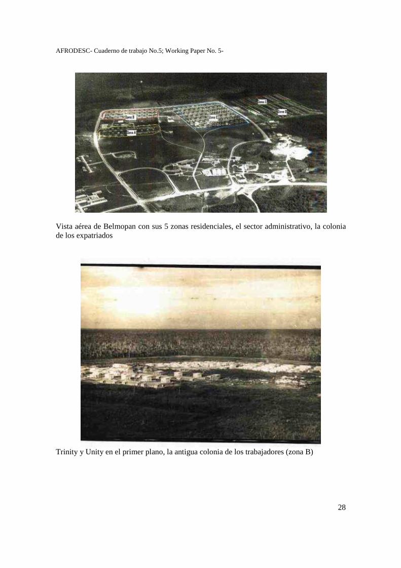
AFRODESC- Cuaderno de trabajo No.5; Working Paper No. 5-
28
Vista aérea de Belmopan con sus 5 zonas residenciales, el sector administrativo, la colonia de los expatriados
Trinity y Unity en el primer plano, la antigua colonia de los trabajadores (zona B)
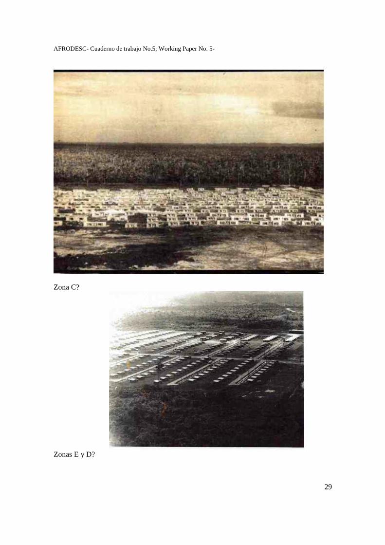
AFRODESC- Cuaderno de trabajo No.5; Working Paper No. 5-
29
Zona C?
Zonas E y D?
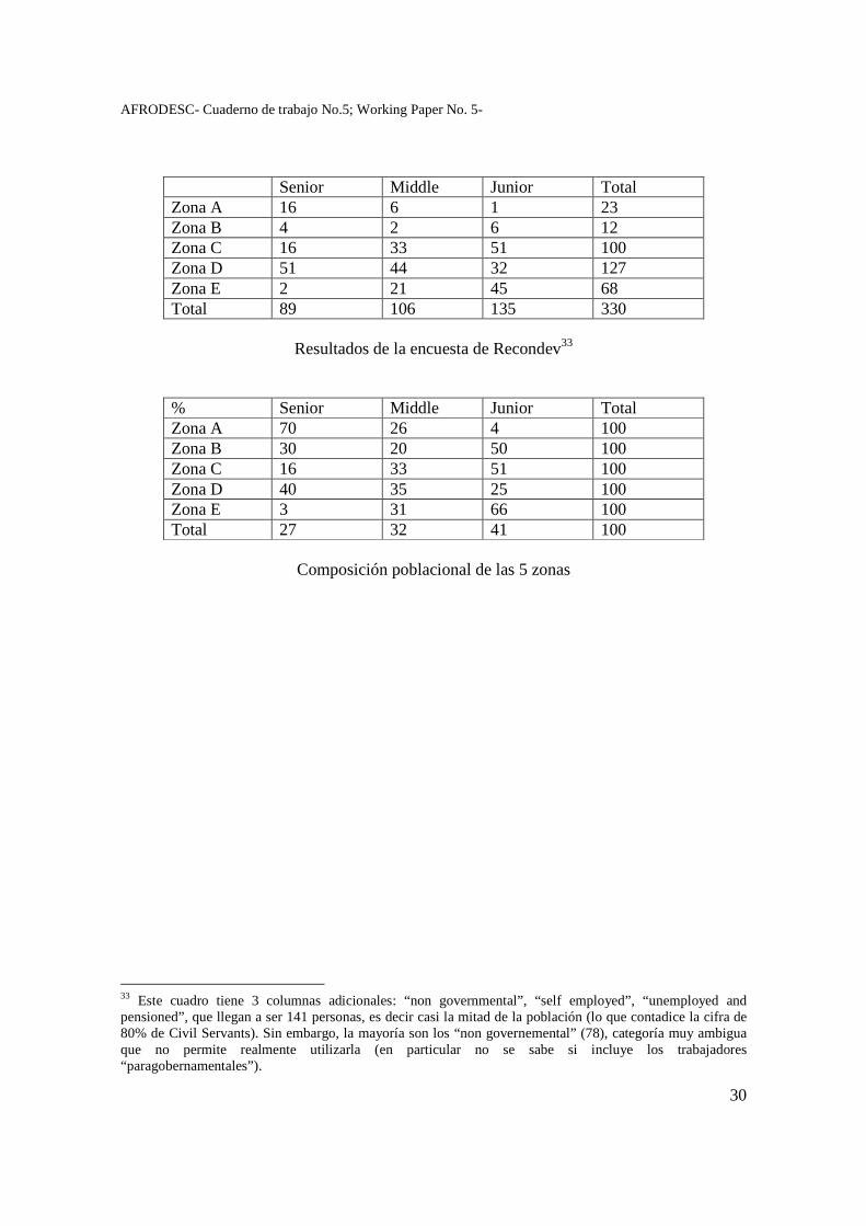
AFRODESC- Cuaderno de trabajo No.5; Working Paper No. 5-
30
Senior Middle Junior Total Zona A 16 6 1 23 Zona B 4 2 6 12 Zona C 16 33 51 100 Zona D 51 44 32 127 Zona E 2 21 45 68 Total 89 106 135 330
Resultados de la encuesta de Recondev33
% Senior Middle Junior Total Zona A 70 26 4 100 Zona B 30 20 50 100 Zona C 16 33 51 100 Zona D 40 35 25 100 Zona E 3 31 66 100 Total 27 32 41 100
Composición poblacional de las 5 zonas
33 Este cuadro tiene 3 columnas adicionales: “non governmental”, “self employed”, “unemployed and pensioned”, que llegan a ser 141 personas, es decir casi la mitad de la población (lo que contadice la cifra de 80% de Civil Servants). Sin embargo, la mayoría son los “non governemental” (78), categoría muy ambigua que no permite realmente utilizarla (en particular no se sabe si incluye los trabajadores “paragobernamentales”).
AFRODESC- Cuaderno de trabajo No.5; Working Paper No. 5-
31
Bibliografía Belize. Abstract of Statistics 2001. Central Statistical Office, Ministry of Finance, Belmopan, November 2001 Colonial Report. British Honduras 1957, 1959. London, Her Majesty’s Stationary Office George Price. Father of the nation of Belize (2000). Belize: Ion Media. The New Capital for Belize, 1967. Published by the Governement Information Service, Belize City, on behalf of the Reconstruction and Development Corporation. February. Printed by the Government Printer (Miscellaneous, part. 1, MC 708) Belmopan Information Service for Reconstruction and Development, s.d. Printed by the Government Printer (Archives: Miscellaneous, part. 1, MC 700) Arana Francis B., 1995. It used to be that… Volume II. Benque Viejo del Carmen, BRC Printing Ltd. Dimond Franck M., s.d. Emergency Plans for the New Capital City of British Honduras (Archives, Miscellaneous, part. 1, MC 561). Dunn K.C. (Labour Commissioner), 1969. Annual Report of the Labour Department for the year 1969. Printed by the Government Printer. Everitt John, 1986. “The growth and development of Belize City”. Journal of Latin American Studies, 18 (1), (May, 1986), 75-111. Published by: Cambridge University Press. Grier A.M. and A.R.G. Prosser, s.d. The Move to the New Capital. British Honduras (Archives, Miscellanous, part. 1, MC574). Hyde Evan, 1970. The crowd called UBAD: the story of a people’s movement. Belize City: Modern Printers. Kearns Kevin C., 1973. “Belmopan: Perspective on a New Capital”. Geographical Review, 63 (2), (April), 147-169. Ministry of overseas development. Llewelyn-Davies Weeks Forestier-Walker and Bor with Social and Community Planning Research, 1974. Belmopan. An ex-post evaluation. London: Oldacres & Co Ltd (Archives, Miscellaneous, part 1, MC-2379) Reconstruction and Development Corporation, 1963. Notice of the 10th Board Meeting. Friday, 14th June, 1963, Legislative Assembly Gallery (Archives, Miscellaneous, part 1, MC 613).
AFRODESC- Cuaderno de trabajo No.5; Working Paper No. 5-
32
Scott & Wilson, Kirkpatrick & Partners, Preece, Cardew & Rider, Norman & Dawbarn, Widnell & Trollope, 1963 (10th May). Report on proposed new capital for British Honduras. Shoman Assad, 1987. Party politics in Belize. 1950-1986. Benque Viejo del Carmen: Cubola Productions. Shoman Assad, 2000. Thirteen chapters of a history of Belize. Belize City: The Angelus Press Limited. [First Ed. 1994]. The Belmopan City Council, The Belize Archives Department, The George Price Centre for Peace and Development, 2005. Pioneers of Belmopan. Document non publié. Topsey H., Awe J., Morris J. & Moore A (1983). “Belmopan before Pauling. An ancient Maya site”. Belizean Studies, Vol. 11, No. 3, 12-20. Entrevistas Chater et Vick Bejos, agencia de viaje, 26 de enero de 2009 Peter Carillo, ingeniero, miembro del consejo municipal, 26 de enero de 2009 John Longsworth, 26 de enero de 2009 Tony Graham, Surveyor, 26 de enero de 2009 y 24 de marzo de 2009 Peter August, Recondev, 24 de marzo de 2009 Chief Ingeneer, Ministry of Works, 25 de marzo de 2009 Inès Sanchez, profesor, ministerio de educación, 25 de marzo de 2009 Julio Castillo, Civil Servant, 25 de marzo de 2009 Ray Davies, Public service Union, Retired civil servant, 25 de marzo de 2009
AFRODESC- Cuaderno de trabajo No.5; Working Paper No. 5-
33
Elecciones y Política en Belize, una exploración cartográfica
ODILE HOFFMANN Centro de Estudios Mexicanos y Centroamericanos (CEMCA),
[email protected] Francia y México
Resumen Este trabajo parte de una doble inquietud: la de reunir datos e informaciones acerca de un país y un sistema político bastante desconocidos en México ; la de explicitar y documentar una serie de paradojas y contradicciones cuyo análisis constituye un reto teórico apasionante por su originalidad. En efecto, el espacio electoral reune una serie de rasgos que llaman la atención. Por un lado ostenta toda la formalidad democrática que muchos países latinoamericanos podrían envidiar: alternancia, alta participación, “popularity” razonable, es decir márgenes de victoria “normales” y credibles, aparente aceptación social de los resultados, instrumentos y organización de votación acorde a pautas internacionales. Y sin embargo, a la vez, se eveidencia una altisima desconfianza de los políticos, poca legitimidad, acusaciones de fraudes y corrupciones múltiples y muy elevadas, denuncias de represión política y restricción de libertad de expresión hasta en los años 1980 (Shoman 1990), etc. La perspectiva “geográfica” asumida consiste en analizar la dinámica electoral en términos de construcción de los espacios electorales, construcción tanto políticos y sociales como materiales, es decir considerando también su proyección espacial en jurisdicciones, entidades administrativo-políticas y unidades censales, etc.
AFRODESC- Cuaderno de trabajo No.5; Working Paper No. 5-
34
Elecciones y Política en Belize, una exploración cartográfica
Este trabajo parte de una doble inquietud: la de reunir datos e informaciones acerca de un país y un sistema político bastante desconocidos; la de explicitar y documentar una serie de paradojas y contradicciones cuyo análisis constituye un reto teórico apasionante por su originalidad. Como se ve, asumo plenamente una visión “desde fuera”, en este caso “desde México”, esperando poder cambiar esta perspectiva hacia una más “internalizada” en el futuro próximo. Algunas palabras claves sitúan el contexto: Belize, país centroamericano y caribeño, hispano e anglófono, mestizo y creole –ambos modelos incluyendo por supuesto toda una gama de otras categorías étnicas-, marginado y estratégico… 300 000 habitantes, 23 000 kilómetros cuadrados. Independiente desde a penas 1981, pero de autogobierno desde 1964 y gozando de elecciones generales desde 1954. El sistema político –una democracia parlamentaria británica modelo Westminter- se caracteriza, entre otras cosas, por un bipartidismo acentuado, que no excluye a terceros (de hecho en la corta historia electoral del país hubo cerca de 15 partidos que contendieron por elecciones nacionales) pero tampoco les deja espacios reales: ningún candidato independiente ha sido electo en la historia electoral del país1. El espacio electoral reúne una serie de rasgos que llaman la atención. Por un lado ostenta toda la formalidad democrática que muchos países latinoamericanos podrían envidiar: alternancia, alta participación, “popularity” razonable, es decir márgenes de victoria “normales” y creíbles, aparente aceptación social de los resultados, instrumentos y organización de votación acorde a pautas internacionales. Y sin embargo, a la vez, se evidencia una altísima desconfianza de los políticos, poca legitimidad, acusaciones de fraudes y corrupciones múltiples y muy elevadas, denuncias de represión política y restricción de libertad de expresión hasta en los años 1980 (Shoman 1990), etc. Es decir, existe un enorme desfase entre la formalidad y la cotidianeidad del que hacer político. No
1Durante 50 años los partidos que incursionaron en la arena electora fueron los siguientes: 1. People’s United Party (since 1954) 2. General Workers Union (GWU) formed coalition with PUP in 1954, 1957 3. National Party (1954, 1957) 4. Honduran Independent Party (1957) 5. National Independence Party (1961) (NP and HIP formed the NIP) 6. NIP-PDM (People’s Democratic Movement) (1969) 7. Christian Democratic Party (1961, y otra vez, distinto, en 1984) 8. United Democratic Party (1974) (NIP-PDM coalition formed the UDP) 9. United Black Association for Development (1974) 10. Corozal United Front (1974) 11. Toledo Progressive Party (1979) 12. National Alliance for Belizean Rights. En 2008 aparecieron otros seis partidos, como se verá en el texto.
AFRODESC- Cuaderno de trabajo No.5; Working Paper No. 5-
35
opongo formalidad a “realidad” pues en política como en otros campos, la forma es parte intrínseca del fondo, es parte de la misma realidad. La perspectiva “geográfica” asumida consiste en analizar la dinámica electoral en términos de construcción de los espacios electorales, construcción tanto políticos y sociales como materiales, es decir considerando también su proyección espacial en jurisdicciones, entidades administrativo-políticas, unidades censales, etc. Con esta perspectiva, y aunque trabajemos con base en datos cuantitativos y poco trabajo de campo, se quisiera escapar al reduccionismo de las cifras, introduciendo la dimensión cualitativa del espacio. Recordemos que en nuestra perspectiva de análisis espacial, las distribuciones de los procesos en el espacio no son más que herramientas que permiten cuestionarnos, evidenciar dudas y problemas, y nunca contestar o dar respuestas definitivas. El análisis espacial siembra dudas, no certidumbres. El sistema electoral: commonwealth, ministers Algunas fechas claves: Honduras Británico, colonia de la Corona Británica desde 1862 1951: sufragio universal adulto para los mayores de 21 (mayores de 18 años a partir de 1978); hasta entonces sólo podían votar los ciudadanos que acreditaban de recursos (propiedad y/o salario “suficiente”), es decir menos de 2000 personas en 1948 (menos de 3% de la población). Primeras elecciones generales en 1954. 1961: HATTIE y la construcción de Belmopan 1963: adopción de la constitución de transición a la independencia 1964: autogobierno (Self-Governing British Crown Colony) 1973: adopción del nombre Belize, que remplaza el de British Honduras 1981: Independencia El sufragio universal se ejerce en elecciones generales desde 1954, es decir mucho antes de la independencia (1981). A partir de 1961 se introdujo el sistema de gobierno ministerial: cada circunscripción elige a un parlamentario que funge o es susceptible de fungir como “ministro de gobierno”. En 1961, todavía bajo el régimen colonial británico, se constituyó un gabinete de 9 miembros (cinco ministros nombrados entre los elegidos por sufragio y uno designado, el Gobernador, el Chief Secretary y el Attorney General o Procurador). Los seis ministerios eran: finanzas, agricultura y desarrollo económico, educación y vivienda, “Public Utilities”, Salud, Bienestar y gobierno local, trabajo. Este sistema proviene del modelo británico luego extendido al Commonwealth, como lo muestran las referencias en la administración pública que se refieren a Australia, New Zeland, Papua New Guinea, las islas Solomon, etc.
AFRODESC- Cuaderno de trabajo No.5; Working Paper No. 5-
36
A medida del crecimiento demográfico, económico e institucional del país, el número de ministros aumentó y la asamblea creció para alcanzar 18 parlamentarios en 1961, 28 en 1984 y finalmente 31 en 2008. Hasta hoy la Reina Isabel de Gran Bretaña es Jefa de estado; el Gobernador general de Belice, siempre un beliceño, nombra a los senadores y ministros en función de los resultados de las elecciones. El poder ejecutivo lo asume el primer ministro, quien es el líder del partido mayoritario, y su gabinete. Las distintas elecciones: espacios y términos, listas Se reconocen cuatro tipos de elecciones.
- el Referendum: se realizó por primera vez en la historia del país en febrero de 2008 para decidir si el Senado debería ser electo2.
- las elecciones generales, en cada una de las entidades político-administrativas o “constituency” (31 desde 2008), cada cinco años desde 1969 (antes eran 4). El periodo siempre se respetó menos en 1993 cuando se adelantó de un año. En 2008 fueron las 13avas elecciones generales en el país.
- las elecciones “municipales”, cada tres años, distinguiendo los concejos de “City” en las dos “grandes ciudades” del país: City Councils de Belize City (once curules) y Belmopan (siete curules), y los de “town” en las otras siete ciudades (Town councils de San Pedro, Benque Viejo, San Ignacio, Dangriga, Punta Gorda, Orange Walk, Corozal, con siete curules cada uno). Los gobiernos municipales gozan de muy poca autonomía o independencia financiera.
- las elecciones locales de “chairman”, “Village” o “Community Council”, cada año. En este caso las elecciones están a cargo de las localidades y el aparato administrativo legal sólo interviene en apoyo logístico. Un folleto de EBD (Elections and Boundaries Department) menciona en 2005 a 191 “Villages and communities”.
Habría que añadir la figura consuetudinaria de “alcalde”, que en Belice se asocia principalmente a las poblaciones maya del sur del país. Los tres primeros tipos de elecciones están supervisados por el Departamento de Elecciones y Fronteras (EBD). Los resultados de las elecciones están publicados en el Gazette Extraordinary, pero en los Archivos Nacionales de Belize (Belmopan) sólo son disponibles las versiones periodísticas. Tomando el ejemplo de 2003 en el que por primera vez se realizaron las elecciones nacionales y locales conjuntamente, se eligieron 29 representantes nacionales y 67 concejeros locales, es decir un total de 96 representantes populares para 156 993 votantes registrados para elecciones generales. Para las últimas elecciones de febrero 2008 el país se divide en seis distritos, 31 circunscripciones y 131 polling áreas. MAPA 1 (Constituencies por distrito). Una tercera parte de las circunscripciones corresponden a Belize city. Otra tercera parte, aproximadamente, a las zonas urbanas del país. Y una tercera parte reagrupa a poblados y 2 La pregunta era: "Should the Senate of Belize be elected?" Ganó el “sí” con más de 60% de los votos.
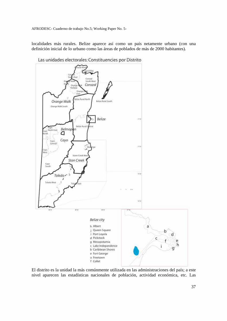
AFRODESC- Cuaderno de trabajo No.5; Working Paper No. 5-
37
localidades más rurales. Belize aparece así como un país netamente urbano (con una definición inicial de lo urbano como las áreas de poblados de más de 2000 habitantes).
El distrito es la unidad la más comúnmente utilizada en las administraciones del país; a este nivel aparecen las estadísticas nacionales de población, actividad económica, etc. Las
AFRODESC- Cuaderno de trabajo No.5; Working Paper No. 5-
38
circunscripciones electorales, o “constituencies” sólo sirven para las elecciones, de la misma manera que las polling areas, que solamente son instrumentos de organización de las elecciones. Es decir, no coinciden forzosamente con las unidades administrativas que son las “ciudades” (town o city) o las localidades que eligen sus “areas representative”. Ahora bien, tanto las listas electorales como las circunscripciones no son meras “arbitrariedades” sino que son ante todo instrumentos de gobierno y por lo tanto construcciones políticas. Su genealogía y su manejo informan sobre la construcción del campo político y de gestión del territorio nacional. La construcción del territorio electoral La construcción del territorio electoral belizeño se hizo en tres grandes etapas. 1954-1957: división del país en 9 constituencies, los primeros pasos de la organización político-administrativa. 1961-1979: se aumenta el número de entidades a 18, sin modificar en sustancia la organización espacial. Sólo se dividen en dos las anteriores, y se crean seis nuevas en Belize City, es decir se adecua a la realidad demográfica y política. Es la base de la acción del “auto-Gobierno”. 1984: se vuelven a dividir las entidades del norte y occidente (Corozal, Orange Walk, Cayo) y se aumentan a 10 las de la Belize City, llegando así a 28 constituencies. Este modelo toma en cuenta la predominancia de la ciudad de Belice. En 1993 y 2008 se dan otros cambios con la creación de tres nuevas divisiones en Belize rural central (1993), Cayo North East y Belmopan (2008). Además, en varias ocasiones y de manera casi permanente el EBD procede a ajustes de fronteras entre divisiones (1997, 1998, 2002, 2004). (ver mapa 1 y cuadro al final). Como es común en todos los países, los reajustes de división electoral siempre despiertan sospechas de “gerrymandering”, es decir el hecho de crear circunscripciones con el objetivo de favorecer un partido en particular. Sin embargo, en el caso de Belize, los resultados no parecen apuntalar esta visión. Si exceptuamos la primera redistritación en 1961, las siguientes se hicieron bajo un gobierno del PUP que perdió las elecciones consecutivas al cambio: en1984 cuando pasa de 18 a 28 constituencies, en 1993 cuando se crea Belize Rural central, y de nuevo en 2008 cuando se crean Belmopan y Cayo North East.3
3 Le gerrymandering est un terme politique nord-américain pour désigner le découpage des circonscriptions électorales avec pour objectif de donner l’avantage à un parti, un candidat, ou un groupe donné. Le terme de charcutage électoral est parfois utilisé. Cette pratique d'optimisation électorale se retourne toutefois fréquemment contre ses auteurs, dans la mesure où une évolution marginale de l'opinion peut conduire à des résultats totalement opposés et faire battre le parti que l'on souhaitait favoriser. Ce terme vit le jour en 1811 quand le gouverneur du Massachusetts, Elbridge Gerry, fut accusé d’avoir « dessiné » une circonscription en forme de salamandre (salamander) afin de favoriser son parti. Wikipedia, 22 julio de 2008.
AFRODESC- Cuaderno de trabajo No.5; Working Paper No. 5-
39
A nivel técnico, la ambición es de cubrir el país con circunscripciones (constituencies) de peso demográfico equivalente (todavía más al nivel inferior de las polling áreas). Esto se verificaba más o menos todavía en 1984, con una relación de la circunscripción la menos poblada a la más poblada era de 1 a 1.62 en cuanto a votos, 1.33 en cuanto a votantes registrados. Es decir, la división la más importante “pesaba” de una tercera a una mitad más que la menos poblada. Esta relación había ido aumentando, hasta alcanzar más de 1 a 4 en 2003, para ambos criterios. La división más poblada “pesaba” cuatro veces más que la menos densamente poblada, ambas con un mismo número de representantes. Esta evolución traduce un proceso de concentración de la población en las áreas ya las más densamente pobladas. La redistritación de 2004 frenó esta tendencia, regresando a una relación menor aunque todavía elevada de 1 a 2,6 en 2008 en cuanto a votos. Ver cuadro al final. De esta manera, la administración redibuja permanentemente las divisiones electorales para limitar en lo posible las disparidades demográficas entre ellas. Esto explica porque tenemos constituencies poco pobladas de enormes superficies (Cayo South, Orange Walk South), y otras densamente pobladas de muy poca superficie: las urbanas, pero también dos áreas constituidas por un rosario de “localidades” o “pueblos” (villages, communities, areas) alrededor de las carreteras: al norte y en el Cayo, ambas zonas agrícolas. Es decir, las divisiones electorales atienden lógicamente en prioridad la gestión de los votantes, es decir de la gente, de la población, y no del territorio o de las “regiones” , sean nacientes o históricas. La cuestión de las listas electorales Varias fuentes mencionan –con cierto orgullo- el porcentaje muy elevado de registro de la población en las listas electorales (de 81 a 90% de los posibles votantes) sin cuestionar mucho las cifras4. Si a este añadimos una participación bastante elevada en las elecciones generales (casi siempre superior al 70%, ver más adelante), tendríamos un país con una muy alta consciencia electoral. Algunos observadores cuestionan sin embargo estas cifras (patted o bloated, Palacio 1993: 34) ya que en algunos casos llegan al 100% de la cifra del censo de los posibles votantes (mayores a 18 años), y no parecen tomar en cuenta la alta movilidad que caracteriza al país desde hace varias décadas5: migración a Estados Unidos, urbanización, crecimiento de Belmopan.
4 The population of the electoral roll at February 2003 was approximately 126,000, representing 91% of voter age population. FINAL REPORT ON BOUNDARY REDISTRICTING BELIZE Of the Second Task Force Appointed by the Elections and Boundaries Commission (2005). 5 “Belize’s population demonstrates high mobility for demographic and geographic reasons. This is not echoed in the Electoral Roll, as the tendency is to remain at the initial registration address and/or ancestral address.” FINAL REPORT ON BOUNDARY REDISTRICTING BELIZE Of the Second Task Force Appointed by the Elections and Boundaries Commission (2005).
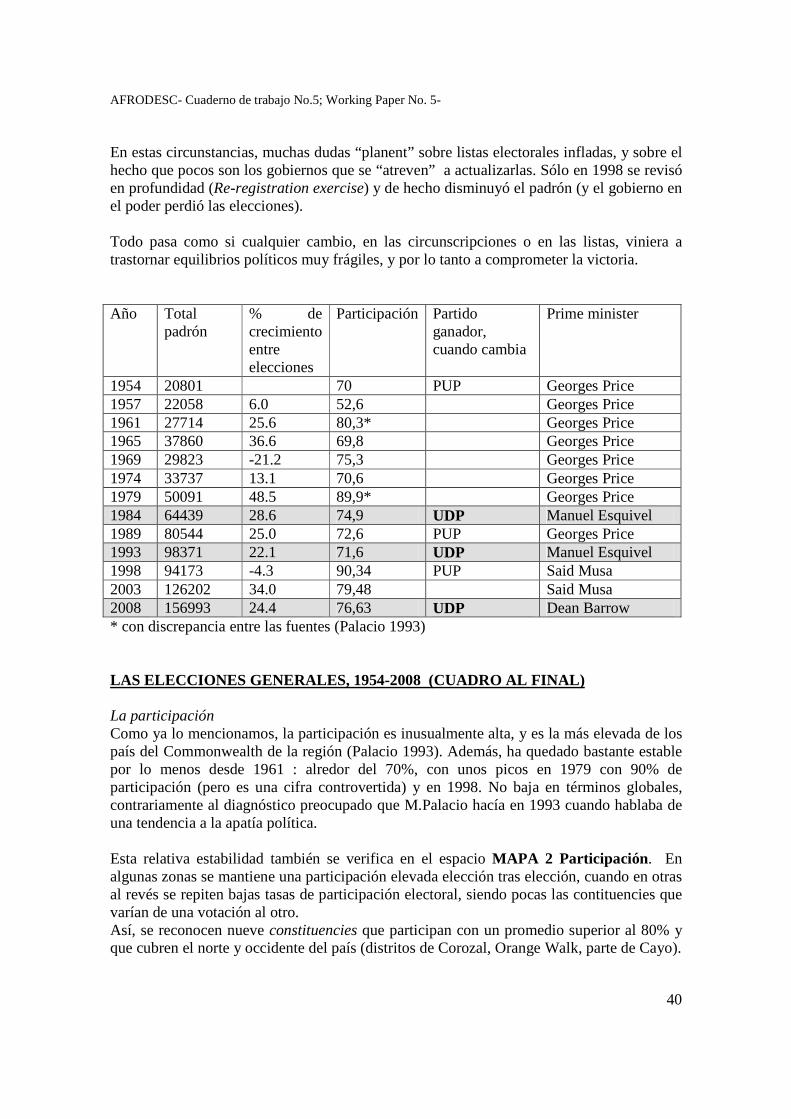
AFRODESC- Cuaderno de trabajo No.5; Working Paper No. 5-
40
En estas circunstancias, muchas dudas “planent” sobre listas electorales infladas, y sobre el hecho que pocos son los gobiernos que se “atreven” a actualizarlas. Sólo en 1998 se revisó en profundidad (Re-registration exercise) y de hecho disminuyó el padrón (y el gobierno en el poder perdió las elecciones). Todo pasa como si cualquier cambio, en las circunscripciones o en las listas, viniera a trastornar equilibrios políticos muy frágiles, y por lo tanto a comprometer la victoria. Año Total
padrón % de crecimiento entre elecciones
Participación Partido ganador, cuando cambia
Prime minister
1954 20801 70 PUP Georges Price 1957 22058 6.0 52,6 Georges Price 1961 27714 25.6 80,3* Georges Price 1965 37860 36.6 69,8 Georges Price 1969 29823 -21.2 75,3 Georges Price 1974 33737 13.1 70,6 Georges Price 1979 50091 48.5 89,9* Georges Price 1984 64439 28.6 74,9 UDP Manuel Esquivel 1989 80544 25.0 72,6 PUP Georges Price 1993 98371 22.1 71,6 UDP Manuel Esquivel 1998 94173 -4.3 90,34 PUP Said Musa 2003 126202 34.0 79,48 Said Musa 2008 156993 24.4 76,63 UDP Dean Barrow * con discrepancia entre las fuentes (Palacio 1993) LAS ELECCIONES GENERALES, 1954-2008 (CUADRO AL FINAL) La participación Como ya lo mencionamos, la participación es inusualmente alta, y es la más elevada de los país del Commonwealth de la región (Palacio 1993). Además, ha quedado bastante estable por lo menos desde 1961 : alredor del 70%, con unos picos en 1979 con 90% de participación (pero es una cifra controvertida) y en 1998. No baja en términos globales, contrariamente al diagnóstico preocupado que M.Palacio hacía en 1993 cuando hablaba de una tendencia a la apatía política. Esta relativa estabilidad también se verifica en el espacio MAPA 2 Participación. En algunas zonas se mantiene una participación elevada elección tras elección, cuando en otras al revés se repiten bajas tasas de participación electoral, siendo pocas las contituencies que varían de una votación al otro. Así, se reconocen nueve constituencies que participan con un promedio superior al 80% y que cubren el norte y occidente del país (distritos de Corozal, Orange Walk, parte de Cayo).

AFRODESC- Cuaderno de trabajo No.5; Working Paper No. 5-
41
Al otro extremo, las diez constituencies con niveles de participación más bajo, casi sistemáticamente en todas las elecciones generales, son las de Belize City. Sólo en 2003 se vislumbran algunas excepciones (o cambio de tendencias?), con dos circunscripciones de Belize City y la de Toledo West que ven su participación electoral aumentar, probablemente por motivos muy localizados como un candidato muy carismático o una cuestión electoral particularmente candente.
AFRODESC- Cuaderno de trabajo No.5; Working Paper No. 5-
42
¿Cómo explicar estas tendencias a la estabilidad, sea en uno u otro sentido, que parece estructurar el espacio electoral nacional? M.Palacio (1993:68) las relaciona con factores que promueven mayor participación, como el nivel socioeconómico (más elevado en el norte), o al contrario la obstaculizan como la migración y movilidad (más elevada en la ciudad) y una cultura política de apatía debida “al desencanto y desconfianza hacia los políticos y el sistema político” (supuestamente más marcado en la ciudad). Seguramente intervienen uno o todos estos elementos, juntos o separados, pero quizás no sean suficientes para explicar la profunda distancia que existe, en cuanto a comportamientos electorales, entre la ciudad de Belize City y la zona rural noroccidental del país. Quizás también juegue un papel la identificación étnica en la participación electoral mayor (hispanos) o menor (creoles), no en sí, por supuesto, sino en la medida en que reflejaría modalidades distintas de organización social y política (rol de la familia, redes clientelares). Las tasas de participación en la elecciones locales confirman esta doble característica, con altas variaciones espaciales y cierta estabilidad temporal, por lo menos desde hace veinte años. Entre las nueve circunscripciones de voto local (los siete Town councils y dos City Councils), se vota más en San Pedro Ambergris, y menos en Dangriga (Palacio 2009). De manera sistemática, la participación electoral es bastante débil en la ciudad de Belize (alrededor de 50%), y siempre mayor en las elecciones generales (de 70 a más de 80%) que en las municipales (las siete ciudades del país, de 60 a 70%) (Palacio 2009). Este resultado es exactamente al opuesto del que se verifica en México, donde las elecciones locales siempre tienen mayor participación que las presidenciales, y éstas más que las de representantes. Sin embargo, en el fondo traducen el mismo proceso: se vota más en el nivel en el que uno se siente más representado, o para el que uno sabe o cree que pueda tener más poder, más posibilidad de intervenir en los asuntos públicos. En el caso de México, este nivel es el municipal, de más cercanía y eficiencia en las mediaciones y negociaciones cotidianas. En Belice, todo apunta a que este nivel sea el nacional. Recordemos que las autoridades municipales gozan de muy poca prerrogativa en Belice, y de un presupuesto mínimo. Y que, al mismo tiempo, los representantes nacionales son muy accesibles a la mayoría de la gente. En todo caso, la participación electoral parece un buen indicador de la vida política nacional y su variación espacial. Cuatro rasgos le dan una efectividad analítica que no siempre tiene en otros contextos: un nivel relativamente alto; una diferenciación según los distritos; una coherencia en el tiempo; el hecho de suscitar debate. La participación no es “neutra” ni automática, es un producto de la vida política local y nacional, un revelador de la cultura política siempre sujeto a negociación y evolución. La alternancia Con el sistema de los “ministros-parlamentarios”, un partido puede ganar una gran mayoría de circunscripciones y gobernar casi solo, en lo legislativo y en el ejecutivo, con una
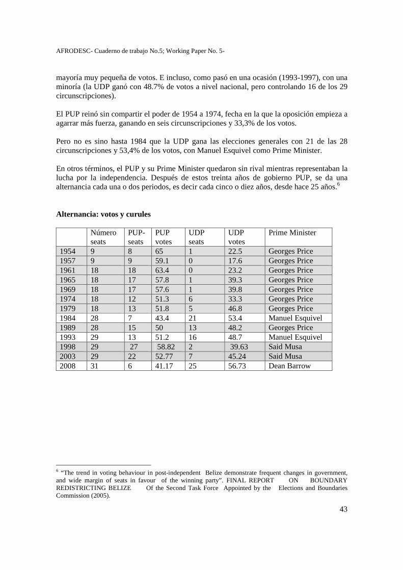
AFRODESC- Cuaderno de trabajo No.5; Working Paper No. 5-
43
mayoría muy pequeña de votos. E incluso, como pasó en una ocasión (1993-1997), con una minoría (la UDP ganó con 48.7% de votos a nivel nacional, pero controlando 16 de los 29 circunscripciones). El PUP reinó sin compartir el poder de 1954 a 1974, fecha en la que la oposición empieza a agarrar más fuerza, ganando en seis circunscripciones y 33,3% de los votos. Pero no es sino hasta 1984 que la UDP gana las elecciones generales con 21 de las 28 circunscripciones y 53,4% de los votos, con Manuel Esquivel como Prime Minister. En otros términos, el PUP y su Prime Minister quedaron sin rival mientras representaban la lucha por la independencia. Después de estos treinta años de gobierno PUP, se da una alternancia cada una o dos periodos, es decir cada cinco o diez años, desde hace 25 años.6 Alternancia: votos y curules
�
Número seats�
PUP-seats�
PUP votes�
UDP seats�
UDP votes�
Prime Minister�
1954� 9� 8� 65� 1� 22.5� Georges Price 1957� 9� 9� 59.1� 0� 17.6� Georges Price 1961� 18� 18� 63.4� 0� 23.2� Georges Price 1965� 18� 17� 57.8� 1� 39.3� Georges Price 1969� 18� 17� 57.6� 1� 39.8� Georges Price 1974� 18� 12� 51.3� 6� 33.3� Georges Price 1979� 18� 13� 51.8� 5� 46.8� Georges Price 1984� 28� 7� 43.4� 21� 53.4� Manuel Esquivel 1989� 28� 15� 50� 13� 48.2� Georges Price 1993� 29� 13� 51.2� 16� 48.7� Manuel Esquivel 1998� 29� 27� 58.82� 2 � 39.63� Said Musa 2003� 29� 22� 52.77� 7� 45.24� Said Musa 2008� 31� 6� 41.17� 25� 56.73� Dean Barrow
6 “The trend in voting behaviour in post-independent Belize demonstrate frequent changes in government, and wide margin of seats in favour of the winning party”. FINAL REPORT ON BOUNDARY REDISTRICTING BELIZE Of the Second Task Force Appointed by the Elections and Boundaries Commission (2005).
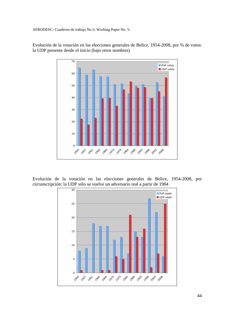
AFRODESC- Cuaderno de trabajo No.5; Working Paper No. 5-
44
Evolución de la votación en las elecciones generales de Belice, 1954-2008, por % de votos: la UDP presente desde el inicio (bajo otros nombres)
�
��
��
��
��
��
��
�
���
��
���
���
��
��
�
���
��
��
��
����
����
� �������
��������
Evolución de la votación en las elecciones generales de Belice, 1954-2008, por circunscripción: la UDP sólo se vuelve un adversario real a partir de 1984
�
�
��
��
��
��
��
���
��
���
���
��
��
�
���
��
��
��
����
����
� �������
��������
AFRODESC- Cuaderno de trabajo No.5; Working Paper No. 5-
45
Esta alternancia pacífica y recurrente, en una América central hundida en guerras civiles en esta misma época, es en sí un elemento digno de subrayar. ¿Cómo explicarla? - por un lado está facilitada por el sistema bipardista y democrático heredado de los británicos e instaurado desde ahora más de medio siglo; en este sentido, se podría ver como una expresión de la democracia asumida y alcanzada: cuando las diferencias son tan pequeñas, una mínima tendencia decide del resultado, como se ve fecuentemente en la mayoría de los países “democráticos” como USA o Europa; - pero por otro lado, al revés, la alternancia también se puede interpretar como la marca de una democracia no alcanzada, donde los resultados no dependen de proyectos ideológicos ni de debates de sociedad, sino solamente de personas e individuos, de contingencias y de azares. En todo caso no deja de sorprender la intensidad y brusquedad de los cambios partidistas, a nivel de constituencies, como se advierte en el mapa siguiente. Se ve como, de una elección a la otra, el mapa puede invertirse completamente: en 1998, el PUP “arrasa” con 27 de las 29 divisiones cuando en las elecciones anteriores (1993) ni siquiera había alcanzado la mayoría; en las siguientes (2003) el PUP conserva su mayoría (22/29 circunscripciones) para perder estrepidosamente en 2008 (con tan sólo 6 de las 31 circunscirpciones). MAPA 3 Alternancia.
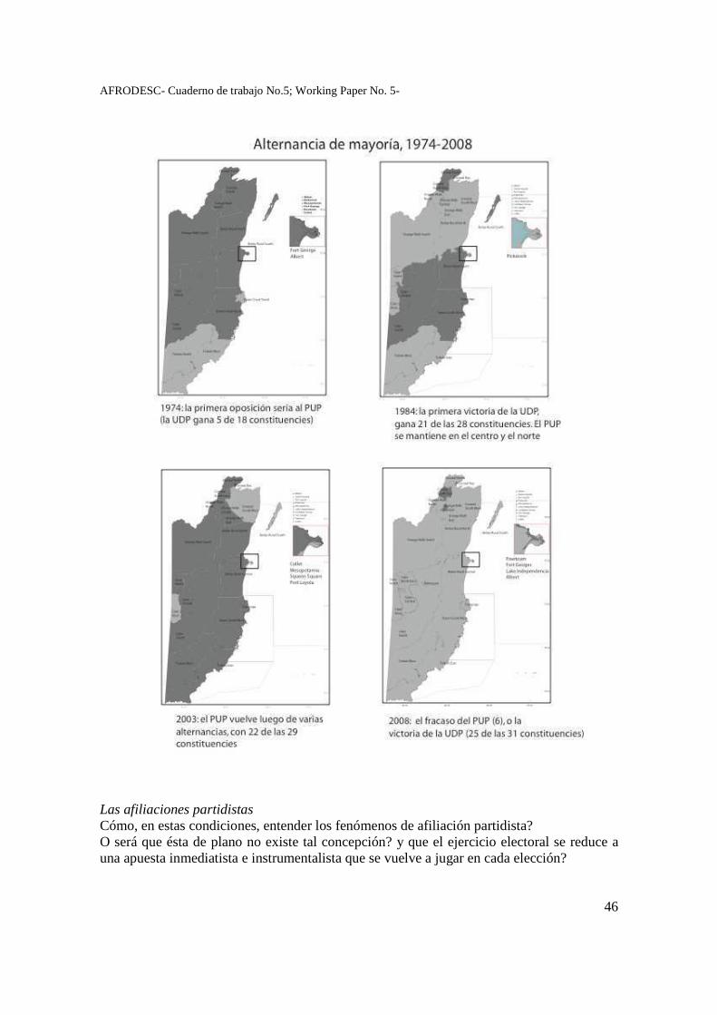
AFRODESC- Cuaderno de trabajo No.5; Working Paper No. 5-
46
Las afiliaciones partidistas Cómo, en estas condiciones, entender los fenómenos de afiliación partidista? O será que ésta de plano no existe tal concepción? y que el ejercicio electoral se reduce a una apuesta inmediatista e instrumentalista que se vuelve a jugar en cada elección?
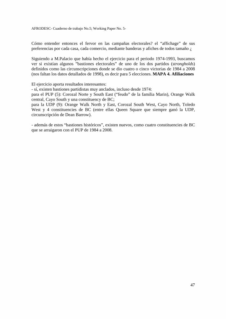
AFRODESC- Cuaderno de trabajo No.5; Working Paper No. 5-
47
Cómo entender entonces el fervor en las campañas electorales? el “affichage” de sus preferencias por cada casa, cada comercio, mediante banderas y afiches de todos tamaño ¿ Siguiendo a M.Palacio que había hecho el ejercicio para el periodo 1974-1993, buscamos ver si existían algunos ”bastiones electorales” de uno de los dos partidos (strongholds) definidos como las circunscripciones donde se dio cuatro o cinco victorias de 1984 a 2008 (nos faltan los datos detallados de 1998), es decir para 5 elecciones. MAPA 4. Afiliaciones El ejercicio aporta resultados interesantes: - sí, existen bastiones partidistas muy anclados, incluso desde 1974: para el PUP (5): Corozal Norte y South East (“feudo” de la familia Marin), Orange Walk central, Cayo South y una constituency de BC; para la UDP (9): Orange Walk North y East, Corozal South West, Cayo North, Toledo West y 4 constituencies de BC (entre ellas Queen Square que siempre ganó la UDP, circunscripción de Dean Barrow). - además de estos “bastiones históricos”, existen nuevos, como cuatro constituencies de BC que se arraigaron con el PUP de 1984 a 2008.
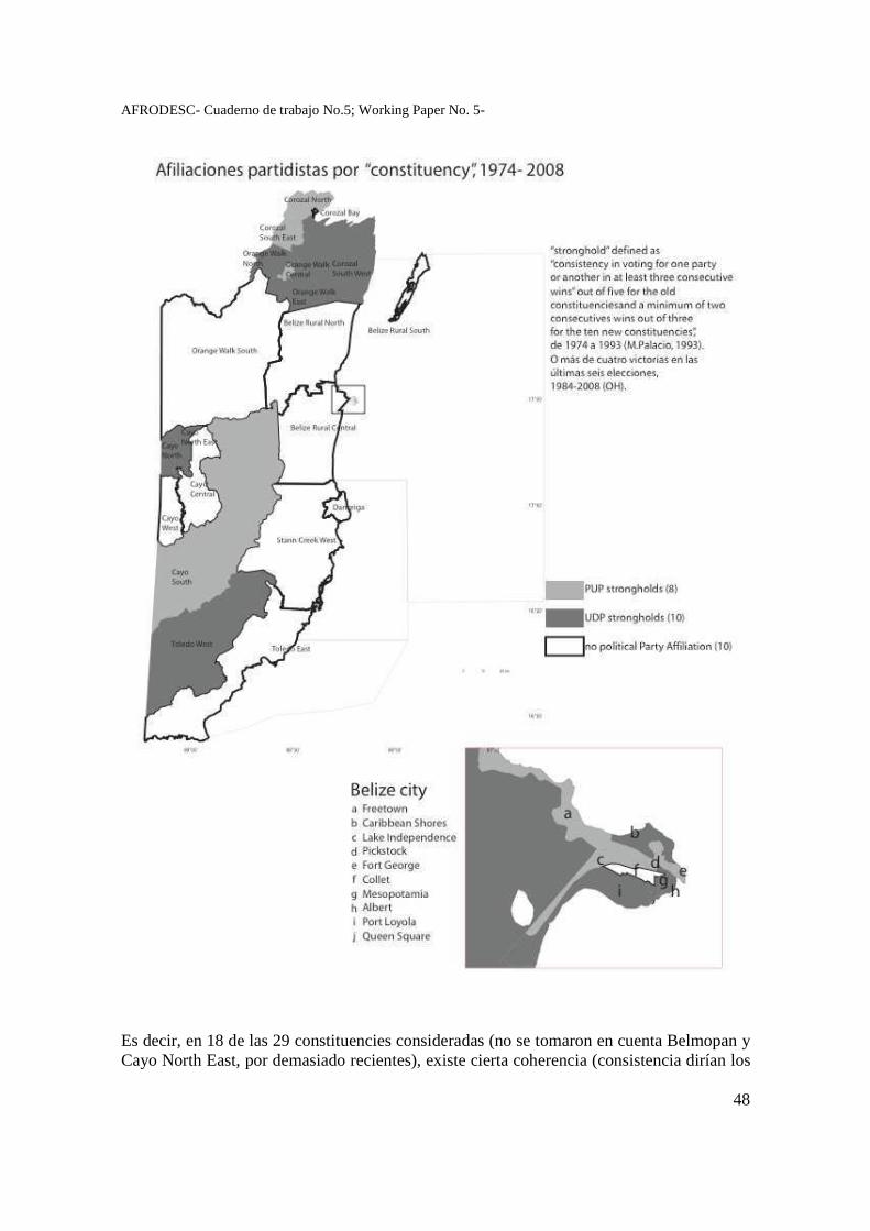
AFRODESC- Cuaderno de trabajo No.5; Working Paper No. 5-
48
Es decir, en 18 de las 29 constituencies consideradas (no se tomaron en cuenta Belmopan y Cayo North East, por demasiado recientes), existe cierta coherencia (consistencia dirían los
AFRODESC- Cuaderno de trabajo No.5; Working Paper No. 5-
49
politólogos) en el voto partidista a lo largo del tiempo. A qué se debe? con qué se puede relacionar? Por un lado, contrariamente a lo que uno podría pensar, estos “bastiones” no se relacionan directamente con una alta participación: ni en Cayo West y central (alta participación y alta alternancia), ni, al otro extremo, en Toledo West o en BC (baja participación y bastión UDP desde 1974). Es decir, los más consistentes no son los que más votan, ni vice-versa. No existe relación directa entre tasa de participación y versatilidad de voto. Otra explicación “natural” no se comprueba: las preferencias partidistas no forman bloques regionales coherentes. Así, tanto en el norte (Corozal y Orange Walk) como en el occidente (Cayo) y en la ciudad de Belice, los “bastiones” de uno y otro partido colindan entre ellos, se imbrican (aun si se puede ver que “the PUP is more popular in Belize City’s north side than the south”, Amandala february 2008). Es por lo tanto difícil interpretar las preferencias en términos socioeconómicos o de contextos “ecológicos” (en el sentido de sistémicos). ¿Dónde está la lógica territorial ¿ Si no son los proyectos ideológicos ni los contextos los que explican ciertas tendencias “duras”, quizás habría que buscar del lado de las personas, siguiendo una vez más a Myrtle Palacio que dice: “The person makes the party rather than vice versa” (Palacio 1993:43). Por su parte, Mónica Toussaint precisa que “la lucha electoral no se ha definido en el enfrentamiento de proyectos económicos y políticos diferenciados (casi los mismo) sino en lealtades y liderazgos personales” (Toussaint 1990, p11) Algunos argumentos van en este sentido: la longevidad de algunos personajes políticos, y su inserción en redes políticas, muchas veces redes de familia también. Actores políticos: veteranos y estrellas En 1993, M.Palacio ya había ubicado algunos “veteranos” definidos así por haber ganado cinco elecciones consecutivas. De los 10 veteranos de 1993, cuatro pasaron a la historia nacional: George Price (PUP Pickstock, ex Prime Minister), Philipp Goldson (UDP, Albert), Florencio Marin (PUP, Corozal South East), Manuel Esquivel (UDP, Caribbean Shores, ex Prime Minister dos veces), al que se podría agregar Said Musa (PUP Fort George, ex Prime Minister, hasta 2008) que ya era electo en 1993. De los 93 candidatos a elecciones generales de 2008, una tercera parte (29) ya lo eran en 2003, y algunos (8) ya eran electos en 1993, 15 años antes (entre ellos Dean Barrow, UDP para Queen Square). Estas cifras parecen indicar cierta “profesionalización” del oficio político. Sin embargo, otros hechos muestran cierto relevo: de las cinco grandes familias políticas (también llamadas por los observadores dinastias, clan, familia, casa) mencionadas en 1993, sólo una queda activa quince años después: la de los Marin, con tres candidatos en 2008, todavía en Corozal. Las demás (Price, Briceño, Lizarraga, Hunter) presentaban sólo un candidato en las elecciones generales de 2008, o ninguno. Es decir, la imagen de “dinastía” no parece tan apegada a la realidad partidista de Belice.
AFRODESC- Cuaderno de trabajo No.5; Working Paper No. 5-
50
Las personas ganan votos en cuanto representan y “personalizan” una circunscripción, se ven como un individuo con el que los votantes se identifican. Asi se entiende mejor las dinastias de las que habla M.Palacio, o la longevidad de algunos hombres políticos. Así se entienden ahora los mapas: no son lógicas territoriales que se expresan, sino lógicas clientelares plasmadas en el espacio (más que en familias o clanes). El matiz es importante: el argumento político no se basa en el territorio (sus problemas, sus características, su población) sino solamente en el arraigo y la pertenencia al espacio, sea cual sea.
Intersticios o trampolines ¿ los candidatos y partidos independientes Uno se podría preguntar por qué sigue habiendo propuestas alternativas al bipartidismo si se sabe que no logran nunca obtener un solo curul? Una respuesta consiste en pensar que los independientes no siguen lógicas territoriales ni contextualizadas por el entorno social, económico o productivo, sino que se desarrollan como instrumentos de negociación con las cúpulas partidistas “tradicionales” : cuando el partido no me presenta como candidato, o no me da chance, me presento como independiente. Globalmente los independientes nunca pesaron mucho en las elecciones, salvo en 1961 cuando agruparon a los disidentes del PUP de 1958 (CDP de Pollard). En 1958 Pollard entra en disidenca del PUP y funda el Democratic Agricultural Labour Party que luego deviene Partido Democratico Cristiano. Sus líderes (Richardson y Goldson) guardan el control del sindicato GWU y luego forman el HIP , antecedente del NIP.7 Y de hecho nunca ganaron curul en circunscripción alguna. Sin embargo, en las últimas tres elecciones, su participación fue mucho mayor a lo anterior (cuadro al final): - en 1998 el número de candidatos “independientes” subió a 23, cifra muy elevada que se mantiene en 2003 (17 candidatos independientes, pero no sé cuantos partidos ni cuales). - en 2008 el número de candidatos “independientes” subió a 29, representando cinco partidos cuya presencia es muy irregular en el país: INDP (3 candidatos), NBA (2), NRP (11), NRTCP (2), VIP (11). Por lo general, los independientes sólo se presentan una vez, casi siempre por no haber logrado la candidatura oficial de uno de los dos partidos. Les sirve para “rester dans la course”, probar su popularidad y eventualmente seguir en la siguiente elección, pero ahora sí bajo la bandera de un partido. Las candidaturas también y sobre todo sirven para acumular capital político al poder negociar los votos que, aunque pocos, son estratégicos. En efecto, debido a la muy debil margen de diferencia entre los dos partidos, los pocos votos de los independientes pueden decidir, y de hecho muchas veces deciden del resultado final.
7 Shoman 1993:196: “los elementos que se habían retirado del PUP en 1956 formaron una coalición con un partido que previamente había sido creado por los británicos y la Belize Estate company, y, en 1962, este Partido Nacional de Independencia…”
AFRODESC- Cuaderno de trabajo No.5; Working Paper No. 5-
51
Conclusiones Esta rápida mirada a medio siglo de práticas politico-electorales en Belice confirma algunas “verdades a medias” acerca de la democracia beliceña : el inicio de la vida política nacional en 1964 con el autogobierno (más que con la independencia de 1981); la predominancia arrasadora del PUP durante la primera mitad de la vida política del país ; su mantenimiento como fuerza principal en el norte del país hasta la fecha; un bipartidismo excluyente de otras alternativas y propuestas; un peso abrumador de lógicas clientelares y personalizadas por encima de proyectos ideológicos. Pero “a medias” solamente en la medida en que no agotan la interpretación de las dinámicas politico-electorales en Belice en el último medio siglo. En efecto, algunos silencios llaman la atención, empezando por los que tienen que ver con la etnicidad, la nacionalidad, la corrupción o la independencia. En cuanto a la primera8, al conocer los resultados de las elecciones generales de 2008, un artículo de periódico resaltaba : “Mr. Barrow becomes Belize’s first black Prime Minister. Remember, though, that it is only by Belizean standards that Mr. Price can be considered white. Nowhere else in the world would he be viewed as such. Still, most Belizeans will consider Hon. Barrow to be our first black Prime Minister. This, of course, is a good thing” (Amandala, Editorial, 8-02-2008). Este tipo de comentario deja pensar que se está gestando una lógica de “racialización de la política” (Henke y Reno, 1993) que, según los testimonios anteriores, había sido ausente en los primeros años del país independiente. Myrtle Palacio en su estudio bastante extenso (1993) no abunda en este tema del papel de la etnicidad en la política. De hecho no menciona la dimensión étnica, y sólo hace una alusion a la especificidad electoral de Dangriga (p30) sin asociarla con los garífunas, categoría que no emplea. Será que hace 15 años no se veía como pertinente? Es lo que pensaba Mónica Toussaint hasta 1990, cuando escribe que “los partidos (son) fundamentalemente electorales, sin una base social de apoyo, (y) distan mucho de identificarse con los intereses de una clase, un grupo o una etnia en particular” (Toussaint 1990, p11). Esta ausencia (algunos dirían “negación”) de lo étnico curiosamente parece haber dejado lugar, bruscamente, a una sobre valoración de lo mismo. Asi, la misma Myrtle Palacio que no lo mencionaba en su estudio de 1993 llama la atención sobre los riesgos de una posible etnicización del voto. Sin embargo, lo hace sin referirse a argumentos estadísticos y hablando de la “comunidad china” en términos a veces equivocos (Palacio 2009: 18, 19, 24) que remiten a ideología más que a análisis político. Lo que es cierto es que ahora ya hace parte del debate nacional. Otras lagunas tienen que ver con el papel de las mujeres (ver Mac Pherson 2007). Si varias de ellas marcaron el paisaje político nacional en las últimas décadas, es de reconocer que en las últimas elecciones generales “desaparecieron” de las escenas públicas : ninguna electa en 2008, y de hechos pocas candidatas. A nivel local, dos de los nueve “Mayors” del país
8 En cuanto a la nacionalidad, sólo quiero dejar sembrada una duda, la que tiene que ver con la política de “venta de pasaportes” – y, por lo tanto, de ciudadanías- durante varios años por parte del gobierno de Belice. Los demás temas, incluyendo el de la corrupción y el narcotráfico, no aparecieron en la documentación recabada hasta la fecha.
AFRODESC- Cuaderno de trabajo No.5; Working Paper No. 5-
52
(Alcalde de Ciudad) son mujeres desde 2006, y una desde 2003. Myrtle Palacio (2009) subraya que “Women have alway dominated the political arena, but generally only as support staff, such as campeaignaig and cooking” (p12). Este misma autora menciona que las cosas están cambiando y que, en las ultimas elecciones lcoales (2009), sí aparecieron las mujeres como alternativas reales a los electores : “Women are being identified by Voters as possible choices for leadership via the vote” (Palacio, 2009:13). Otras más se refieren a la aparente ausencia de relación entre elecciones generales y elecciones locales, ausencia tanto más aberrante cuando vimos la importancia del espacio y del arraigo geográfico en la vida política de Belice. ¿Qué pasa localmente en las elecciones? ¿Es congruente o contradictorio con las elecciones generales? ¿Aparecen otras lógicas? ¿Cómo se articula el poder local con el juego político electoral ? Terminando estas líneas, acabo de leer el último trabajo de Myrtle Palacio (2009) que trata precisamente de las elecciones municipales y pone en evidencia algunos desfases entre los comportamientos políticos a nivel nacional y a nivel local. La participación electoral es uno de ellos, como ya vimos; la contribución de la mujeres, mayor en las elcciones locales que en las generales, es otro. La metodología utilizada en este trabajo, sustentada principalmente en datos estadísticos, no permite abundar en la hipótesis planteada al inicio acerca del desfase entre formalidad y ejercicio cotidiano de la política. Sólo podemos, en esta etapa, ubicar este cuestionamiento en la reflexión sobre cultura política, y recordar las conclusiones de Assad Shoman que resalta el hecho que, de manera general y en Belice en particular ; “El poder ejecutivo es ejercitado dentro de los límites permitidos por la cultura política” y que la historia política del país no ha propiciado una cultura de libertad sino, al contrario, una cultura del autoritarismo anclada en los antecedentes de esclavitud y colonialismo (Shoman 1993: 205-206). Manera elegante de contestar la validez del ejercicio del poder en Belice. Por su parte, analizando las elecciones de Cd Belize en 1991, Myrtle Palacio subrayaba el sentimiento de hastío del electorado frente a hombres políticos que no cumplen (“The electorate’s feeling of alienation is obvious”, Palacio1991:56). Analizaba como el lugar abandonado por los dirigentes políticos era ocupado por los medias, en particular a través de los “talk shows” donde la gente habla y denuncia directamente a los periodistas en lugar de pasar por los instituciones establecidas o por sus representantes electos (“The politicians are not making themselves available to the people who turned out to vote for them”, Palacio1991:56). Es interesante ver que estas mismas observaciones, quince años después, en 2009, son interpretadas de manera radicalmente diferente. Ahora esta irrupción o intervención del radio se ve en términos de contribución a la “buena gobernanza”, y a un esquema de democracia en el que los medias adquirieron un lugar de primera fila, al lado de los partidos políticos y de las instituciones que organizan el voto (EBD) (Palacio 2009:4). Un último comentario en esta fase muy preliminar del trabajo tiene que ver con la dimensión espacial de los procesos electorales que quisimos resaltar, ubicándolos además en la escala temporal permitida por los datos, es decir medio siglo. Ciertamente se advierten regularidades regionales en sus preferencias partidistas. Estas se vinculan de manera

AFRODESC- Cuaderno de trabajo No.5; Working Paper No. 5-
53
prepondeante con personalidades, trayectorias y redes familiares, más que con los contextos estructurales de los espacios (población, producción comunicación). Sin embargo, sería necesario seguir analizando la dimensión espacial de la vida política a un nivel más fino, el de las localidades o polling areas. Es lo que esperamos hacer en un futuro cercano.
AFRODESC- Cuaderno de trabajo No.5; Working Paper No. 5-
54
Bibliografía
Bolland, Nigel, 2004, Colonialism and Resistance in Belize. Essays in Historical Sociology, Cubola Books, Belize (en particular pp199-224 capítulo Ethnicity, Pluralism and Policitcs in Belize) Final report on boundary redistricting belize of the Second Task Force, Appointed by the Elections and Boundaries Commission (2005) (website EBD Elections and Boundaries Department, 21 july 2008) Henke, Holger y Fred Reno (ed.) 2002 Modern Political Culture in the Caribbean, UWI Press, Barbados, Jamaica, Trinidad and Tobago Mac Pherson, Anne S. 2007 From Colony to Nation- Woen Activists and the Gendering of Politics in Belize, 1912-1982, University of Nebraska Press. �
Palacio, Myrtle, 1991, Elections in Belize City: Who is participating? A critique of our Voting System, Spear SOB Conference Oct 1991, SPEAReports 7, pp48-60, (SPEAR Fourth Annual Studies on Belize Conference) Palacio, Myrtle, 1993 Who and What in Belize Elections, 1954 to 1993, Glessima Research & Services Ltd. Palacio, Myrtle , 2009, A Review of municipal Elections in Post Independent Belize, mcn. (http://www.belize-glessimaresearch.org/publications.html) Shoman Assad, 1987, Party Politics in Belize, 1950-1986. Cubola Productions, Benque Viejo Shoman Assad, 1993, “Belice: un Estado autoritario democrático en Centroamérica”, pp181-212 en Francesca Gargallo y Adalberto Santana (comp.) Belice: sus fronteras y destino, UNAM, México Toussaint, Mónica 1990 “Las elecciones en Belice: del espejismo bipartidista a la realidad neocolonialista” en Secuencia, vol. 18, Instituto Mora, sep-diciembre 1990, pp. 5-16.
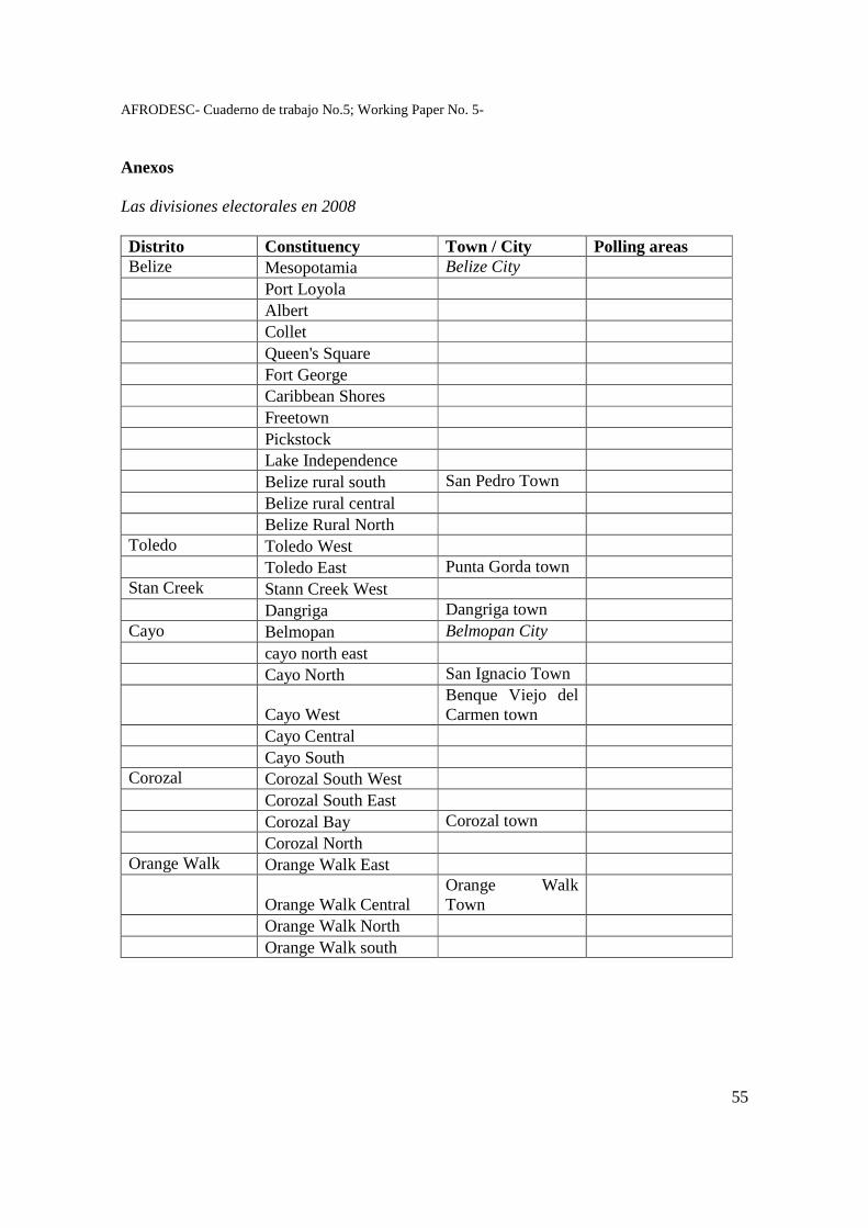
AFRODESC- Cuaderno de trabajo No.5; Working Paper No. 5-
55
Anexos Las divisiones electorales en 2008 Distrito � Constituency� Town / City� Polling areas�Belize� Mesopotamia� Belize City� �
� Port Loyola� � �
� Albert� � �
� Collet� � �
� Queen's Square� � �
� Fort George� � �
� Caribbean Shores� � �
� Freetown� � �
� Pickstock� � �
� Lake Independence� � �
� Belize rural south� San Pedro Town� �
� Belize rural central� � �
� Belize Rural North� � �
Toledo� Toledo West� � �
� Toledo East� Punta Gorda town� �Stan Creek� Stann Creek West� � �
� Dangriga� Dangriga town� �
Cayo� Belmopan� Belmopan City� �
� cayo north east� � �
� Cayo North� San Ignacio Town� ��
Cayo West�Benque Viejo del Carmen town�
�
� Cayo Central� � �
� Cayo South� � �
Corozal� Corozal South West� � �
� Corozal South East� � �
� Corozal Bay� Corozal town� �
� Corozal North� � �
Orange Walk� Orange Walk East� � �
�
Orange Walk Central�Orange Walk Town�
�
� Orange Walk North� � �
� Orange Walk south� � �
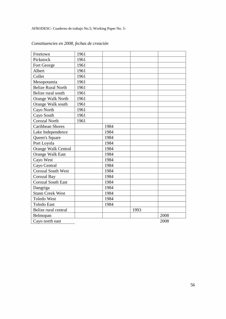
AFRODESC- Cuaderno de trabajo No.5; Working Paper No. 5-
56
Constituencies en 2008, fechas de creación Freetown� 1961� � � �
Pickstock� 1961� � � �
Fort George� 1961� � � �
Albert� 1961� � � �
Collet� 1961� � � �
Mesopotamia� 1961� � � �
Belize Rural North� 1961� � � �
Belize rural south� 1961� � � �
Orange Walk North� 1961� � � �
Orange Walk south� 1961� � � �
Cayo North� 1961� � � �
Cayo South� 1961� � � �
Corozal North� 1961� � � �
Caribbean Shores� � 1984� � �
Lake Independence� � 1984� � �
Queen's Square� � 1984� � �
Port Loyola� � 1984� � �
Orange Walk Central� � 1984� � �
Orange Walk East� � 1984� � �
Cayo West� � 1984� � �
Cayo Central� � 1984� � �
Corozal South West� � 1984� � �
Corozal Bay� � 1984� � �
Corozal South East� � 1984� � �
Dangriga� � 1984� � �
Stann Creek West� � 1984� � �
Toledo West� � 1984� � �
Toledo East� � 1984� � �
Belize rural central� � � 1993� �
Belmopan� � � � 2008�Cayo north east� � � � 2008�
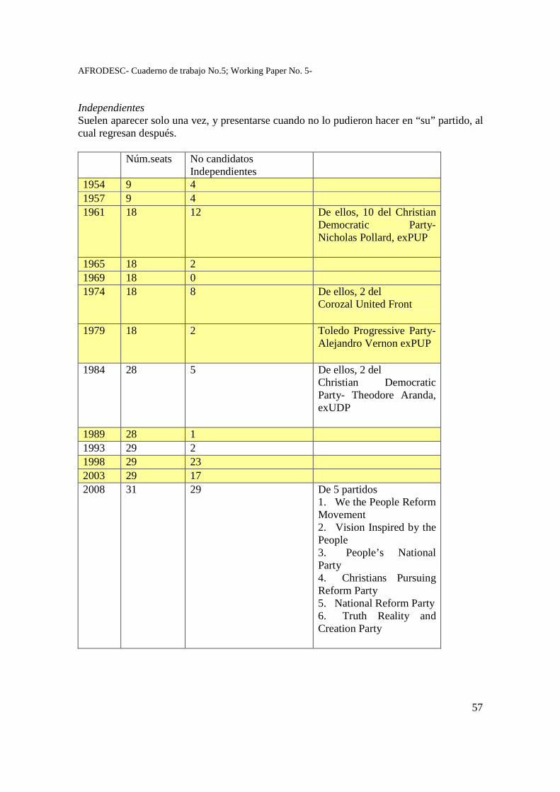
AFRODESC- Cuaderno de trabajo No.5; Working Paper No. 5-
57
Independientes Suelen aparecer solo una vez, y presentarse cuando no lo pudieron hacer en “su” partido, al cual regresan después. � Núm.seats� No candidatos
Independientes��
1954� 9� 4� �
1957� 9� 4� �
1961� 18� 12� De ellos, 10 del Christian Democratic Party-Nicholas Pollard, exPUP �
1965� 18� 2� �
1969� 18� 0� �
1974� 18� 8� De ellos, 2 del Corozal United Front �
1979� 18� 2� Toledo Progressive Party-Alejandro Vernon exPUP �
1984� 28� 5� De ellos, 2 del Christian Democratic Party- Theodore Aranda, exUDP �
1989� 28� 1� �
1993� 29� 2� �
1998� 29� 23� �
2003� 29� 17� �
2008� 31� 29� De 5 partidos 1. We the People Reform Movement 2. Vision Inspired by the People 3. People’s National Party 4. Christians Pursuing Reform Party 5. National Reform Party 6. Truth Reality and Creation Party �

AFRODESC- Cuaderno de trabajo No.5; Working Paper No. 5-
58
Distancia entre circunscripciones, en cuanto a pesos de votantes registrados y votos
� total votos�votantes registrados�
1984� 1.62� 1.33�1989� 2.11� 1.64�1993� 2.69� 2.24�1998� 3.49� 3.48�2003� 4.12� 4.2�2008� 2.65� �
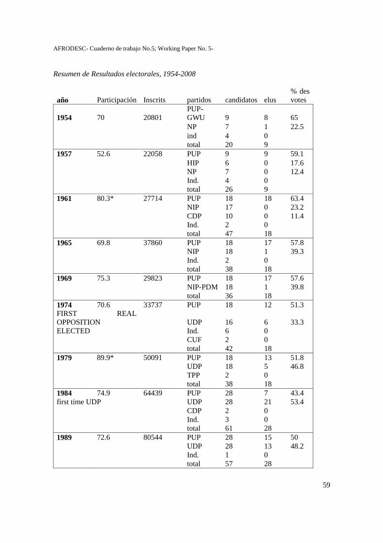
AFRODESC- Cuaderno de trabajo No.5; Working Paper No. 5-
59
Resumen de Resultados electorales, 1954-2008
año� Participación� Inscrits� partidos� candidatos� elus�% des votes�
1954� 70� 20801�PUP-GWU� 9� 8� 65�
� � � NP� 7� 1� 22.5� � � � ind� 4� 0� � � � � total� 20� 9� �1957� 52.6� 22058� PUP� 9� 9� 59.1� � � � HIP� 6� 0� 17.6� NP 7 0 12.4 Ind. 4 0 total 26 9 1961 80.3* 27714 PUP 18 18 63.4 NIP 17 0 23.2 CDP 10 0 11.4 Ind. 2 0 total 47 18 1965 69.8 37860 PUP 18 17 57.8 NIP 18 1 39.3 Ind. 2 0 total 38 18 1969 75.3 29823 PUP 18 17 57.6 NIP-PDM 18 1 39.8 total 36 18 1974 70.6 33737 PUP 18 12 51.3 FIRST REAL OPPOSITION UDP 16 6 33.3 ELECTED Ind. 6 0 CUF 2 0 total 42 18 1979 89.9* 50091 PUP 18 13 51.8 UDP 18 5 46.8 TPP 2 0 total 38 18 1984 74.9 64439 PUP 28 7 43.4 first time UDP UDP 28 21 53.4 CDP 2 0 Ind. 3 0 total 61 28 1989 72.6 80544 PUP 28 15 50 UDP 28 13 48.2 Ind. 1 0 total 57 28
AFRODESC- Cuaderno de trabajo No.5; Working Paper No. 5-
60
1993 71.6 98371 PUP 29 13 51.2
MINORITY GOV. UDP-NABR 29 16 48.7
Ind. 2 0 total 60 29 1998 90.34 94173 PUP 29 27 58,82 UDP 29 2 39,63 Ind. 23 0 total 81 29 2003 79.48 126202 PUP 29 22 52.77 UDP 29 7 45.24 Ind. 17 0 total 75 29 2008 76.63 156993 PUP 31 6 41.17 UDP 31 25 56.73 Ind. 29 0 total 91 31
AFRODESC- Cuaderno de trabajo No.5; Working Paper No. 5-
61
Reconsidering the politics of race, migration and participation in Belize
DAVID HOWARD Institute of Geography, University of Edinburgh
Summary With a current population of 290,000, Belize has undergone a rapid demographic increase during the last three decades, primarily as a result of immigration from neighbouring states. The paper analyses the impact of contemporary demographic mobility and concomitant political and nationalist tensions in Belize. The study is based on interviews undertaken in two communities along the Mexican and Guatemalan borders, and considers racial discrimination and prejudice in Belizean society at large.
The current influx of predominantly Spanish-speaking migrants has significantly altered the historically sensitive balance between mestizo, creole, Garifuna and indigenous groups. Longstanding unease between mestizo and creole political parties and nationalist factions has been exacerbated by tensions over access to environmental and social resources and the challenge of a rapidly increasing population, fuelled by the recent immigration from the nearby countries of Guatemala, El Salvador, Honduras and Nicaragua. A fifth ethnic group, the Mennonites, descendants of a German-speaking religious sect from Mexico and Canada, is numerically small, but makes a significant contribution to agricultural production and marketing systems in Belize. The political and economic interplay of these ethnicities in the context of resource development, a reconceptualisation of racialised categories and political participation form key aspects of this study. Key words: nationalism, race, politics, immigration, territory
AFRODESC- Cuaderno de trabajo No.5; Working Paper No. 5-
62
Reconsidering the politics of race, migration and participation in Belize
Introduction
I would like to speak on the initial pilot study which I undertook in San Felipé and Bullet Tree Falls between December of 2003 and January 2004, which has been augmented by subsequent research initiatives at the University of Edinburgh. The series of 22 interviews undertaken as part of a pilot study have acted as the basis for a wider research proposal which I am working on with Neil Sturart and Patrick Meir, also at the University of Edinburgh. My background is that of a human or social geographer, while my colleagues expertise focus in ecology and environmental change and Geographical Information Systems respectively. We hope to combine our respective research agendas in this wider Belize project. The main question asked is: what are the socio-economic and environmental impacts of recent rapid population increase in Belize, and how are these challenges reflected in the political landscape?
The two field sites for the initial and proposed studies are Bullet Tree Falls, north-east of San Ignacio and San Felipé, south-east of Orange-Walk. These sites were chosen to exemplify human-affected boundaries between natural vegetation (forest and savanna) and agriculture. The former location of Bullet Tree Falls lies close to the Guatemalan border. The village is a former centre of logging activity, now surrounded by cleared agricultural land and signs of widespread land sales for development. My interviews here were with the village ‘elders’, who were all former or current milperos and their partners. Of the twelve interviewed, four were women. The latter interview site of San Felipé to the north has a similar logging history, but current employment for the villagers is much influenced by the service industry of Orange Walk, the surrounding cane fields and the agricultural businesses of the Mennonite communities who settled initially in the 1950s. In San Felipé, three village elders were interviewed - three of whom were women.
At each field location, the purpose of interviewing the older residents of the communities was to record their accounts of demographic and land use change, and to return next year to match these oral histories with more quantitative measurements of land use change - namely soil-surface profiles and carbon content. Further interviews and the recording of local oral histories will provide the key basis for establishing the age of fields and to record land use change. The land use surveys from 1956 onwards have provided general data of land use change.
Both field sites have experienced marked land use transition, from relatively undisturbed tropical forest, to low intensity milpa farming (shifting cultivation) and selective logging in the 1850s and to the introduction of intensive mechanized arable farming since the 1950s. These changes on land use have been accompanied by substantial demographic change, largely led by immigration. Population growth in recent times has occurred in three phases: 1) the arrival of Maya peoples from Mexico since the 1850s; 2) the arrival of Mennonite groups since the late 1950s (principally in the case of San Felipé) and most recently, 3) the arrival of largely Salvadoran refugees and settlers since the 1980s (refs). The study at San Felipé focuses specifically on the land use changes since the 1950s, when the Mennonites communities introduced large scale and mechanized cultivation.
AFRODESC- Cuaderno de trabajo No.5; Working Paper No. 5-
63
In the course of this talk I would like to address the political context of the demographic transition for Belize at large, and then from the interview evidence recorded at Bullet Tree Falls and San Felipé discuss how population increase and demand for land have affected the social context of these two communities. In particular, I focus on the impact of firstly, residential segregation and secondly, violence or social tensions between existing settlers and migrants. One of the key findings is the importance of competition for territorial control or access to land between Belizean mestizo ‘settlers’ and Salvadoran or Guatemalan migrants. Population increase - immigration in particular With a current population of 290,000, Belize has undergone a large demographic increase (over 45 percent) during the last two decades, primarily as a result of immigration from neighbouring states (Woods, Perry and Steagall 1997). This dramatic demographic shift lies at the core of this research. Recent immigration has impacted on political, social and economic structures, new settlement patterns and the use of existing resources (Few 2000). The influx of this predominantly Spanish-speaking population has significantly altered the historically sensitive balance between mestizo (of Spanish and indigenous ancestry), creole (of African or European descent), Garifuna (descendants of exiled African slave workers from St Vincent) and indigenous groups. The most recent census indicates that these four categories constitute approximately 48 percent, 25 percent, 6 percent and 9 percent respectively of the total population (Central Statistical Office 2003). A fifth ethnic group, the Mennonites, descendants of a German-speaking religious sect from Mexico and Canada, is numerically small, but makes a significant contribution to agricultural production and marketing systems in Belize.
The longstanding unease between mestizo and creole political parties and nationalist factions has been exacerbated by economic and social tensions over access to resources and the challenge of a rapidly increasing Spanish-speaking population in traditionally creole-dominated mainstream political and cultural landscapes (Edmond 1983, Bolland 1988, Spear Report 1 1990, Spear Report 2 1990, Medina 1997, Whittaker Augustine 1998, Shoman 2000). The following discussion, however, moves away from the broader societal concerns over creole and mestizo tensions by addressing conflict within predominantly Spanish-speaking villages in Belize.
First, I will note the recorded population increases in recent census, and highlight briefly the consistent bias in summaries of this data as distributed by the Central Statistical Office. Bullet Tree Falls population is estimated currently at 1,900. The 1,000 increase between the 1980 and 1991 census (from 438 to 1,432) pinpoints a dramatic threefold increase in the village population. This increase is largely due to the arrival of Guatemalan and Salvadoran migrants during that decade. San Felipé population is estimated at 1000, increasing from 585 in 1980 (853 in 1991). While the population growth has been less marked, the social impact of non-Belizean in-migrants has created similar tensions.
Despite these totals, one should note an acknowledged undercount in all census data (estimated at around 3%, but local informants have contested this and suggest a much higher figure). One should also note the shift evident in 1991 census from urban to predominantly rural population (52%). This was continued at 2000 census, and emphasises the arrival of new immigrants to the rural Belizean economy. Demographic increase,
AFRODESC- Cuaderno de trabajo No.5; Working Paper No. 5-
64
therefore, is largely due to immigration, and notably so along frontier areas with Mexico and Guatemala. As such, both Bullet Tree Falls and San Felipé might be considered as frontier communities in both spatial and demographic terms.
‘Traditional’ or historic creole /mestizo tensions are evident in the anti-mestizo text of the last Census report in 2000. Related in the political arena to the demographic balance of electoral leverage. Zee Edgell in her novel Beka Lamb (1982) succinctly pins down these social and political nuances of perceived racialised threat: Bill Lamb, father of Beka, although supporting the anti-colonial PIP is careful not to be seen as ‘pro-Spanish’: referring to his Guayabera shirts, recently ironed by his mother Granny Ivy, he states:
‘I may not wear those shirts for a while, ma, thank you all the same, though
I must say the style is useful.’ ‘That’s sudden. You said you preferred them for meetings instead of coats and neckties!’ ‘I don’t want the town to assume I favour Guatemala. Rumour has it that P.I.P. received aid from the Guats to help start the party. Anybody wearing guayaberas, nowadays, is suspected of Latin leanings.’
These tensions exist still in Belizean society, evidently, but within the mestizo communities (themselves founded during the 1870s by Mexican migrants fleeing the Yucatan wars), there has developed a potent Belizean mestizo/ ‘alien’ conflict, where the cultural differences between mestizos and the recent immigrants are overemphasised to negate the shared element of the Spanish language.
The most recent census report is wary of ‘Latin leanings’ but principally concerns itself with the ‘unprecedented high levels of immigration’ (p. 5). The summary highlights the ‘ethnic shift’ (p.6) in 1980 to a mestizo majority. In 2000, census recorded 48.7% mestizo and 24.9% creole – for Cayo and Orange Walk the mestizo proportion was 64% and 77% respectively. This implied demographic ‘problem’ is outlined in terms of a linguistic threat in the census summary. Just over half the population (53.6%) spoke ‘our official language’, which according to the author of the Central Statistical Office, ‘points to the need for some serious corrective measures, especially in view of the fact that fluency in an established language is an indispensable tool for the acquisition of any other form of knowledge’ (p.7 ). At the outset of the census, it is noted that incidents of undercounting were sometimes due to language ‘problems,’ singling out the Chinese community in particular as ‘offenders.’ Birthplace data clearly separates Belizeans from ‘aliens’, indicating that the latter made up 15 percent of the population. Overall, the CSO abstracts of statistics and censuses have maintained a consistent bias against the Spanish-speaking population of Belize.
The mestizo-creole tensions were referred to in the interviews conducted in Bullet Tree Falls and San Felipé, but the clearest cause of concern and antagonism voiced by long-term resident was the relatively recent levels of immigration, principally since the 1980s. I will outline next the two apparent concerns of 1) residential segregation and 2) the perceived threat of social antagonism and violence.
AFRODESC- Cuaderno de trabajo No.5; Working Paper No. 5-
65
Residential segregation I focus now on the territorial and occasionally violent confrontations which have occurred between self-ascribed racialised groups in the village of San Felipé in the primarily sugar-growing district of Orange Walk, northern Belize.i Located 16 km from the Mexican border with a current population of approximately 1,600 people, the settlement was founded by the Wicab and Magaña families who had migrated from the Yucatan during the Caste Wars between the 1840s and 1870s. Their descendants still live in the village, and with several other households of Yucatec Maya descent, have consistently maintained important positions on the village council. Less than a dozen elderly residents of the village speak Mayan languages fluently, although a shared Maya mestizo heritage, in social, cultural and racialised terms, has assisted feelings of group solidarity beyond the routine annoyances and tensions of village life. The collective recognition of shared territorial descent and common familial histories has served in several instances to separate these families both socially and politically from more recent settlers arriving from Guatemala and specifically El Salvador during the 1970s and 1980s.
The population of the village has doubled since the early 1980s mainly as a result of the in-migration by workers and households from neighbouring states. The majority of these recent residents were migrating from regional civil violence during which an estimated 300,000 people were killed and 2 million displaced during the latter half of the last century in El Salvador, Guatemala and Nicaragua (Montejo 1987, Green 1999, Kay 2001). The signing of peace accords in 1992 for El Salvador and in 1996 for Guatemala reduced the absolute numbers of refugees to Belize, but the arrival of predominantly Spanish-speaking migrants to Belize, estimated at 80,000 since 1980, has intensified anti-immigration and racialised discourse during the last twenty years to unprecedented levels. It is in this context that the importance of territorial acquisition and racialised difference has underlined physical aggression and tension between residents of San Felipé.
The role of the village council with respect to communal recognition, lore and access to land has played a key role in separating mestizo residents and new arrivals or ‘aliens’ to San Felipé. Residential and subsequent social segregation are thus reproduced and reinforced within the village. Land for new housing and milpa farming is traditionally bestowed by the village council, the leader of which is rotated, but the membership remains vested in the long-term resident mestizo population of San Felipé. Failure of the new immigrants to consult the village council or their adoption of de facto squatting rights has spatially divided San Felipé into the broadly mestizo, or Maya-origin community at the southern part of the village and the largely Salvadoran migrants in the northern section. The latter state that the village council failed to grant legitimate them fair or adequate parcels of land, while members of the former claim that the new arrivals did not respect existing land ownership patterns and the due process of land allocation. Land, in terms of territorial claims for use or possession, was one of the first material conflicts which led to a series of tensions during the 1980s. The changing land use within the village limits was directly related to immigration-related tensions, underpinned by racialised conflict.
AFRODESC- Cuaderno de trabajo No.5; Working Paper No. 5-
66
Violence - actual and threatened social conflict Interviews with Mayan mestizo and Salvadoran residents, who were living in the village at the time, recount a peak of aggressive confrontations between established and more recent arrivals during the early 1980s, which resulted in a heightened police presence and more frequent military patrolling of the village. The then members of the Yucatec Maya-dominated village council recall that they alerted the district police over concerns of drug-trafficking, armed violence and anti-social behaviour among the ‘aliens’ who were settling on the north-eastern edge of San Felipé. The village council traditionally allocates plots of land to new arrivals. Several of the elderly Yucatec Maya gave detailed accounts of their interviews on arrival to the city with the council, during which they had to prove that they were of ‘good character’ and intended to settle permanently in the village. Their concerns were that the newer arrivals were not following this procedure and had begun cultivating land without regard to the village authority.
Salvadoran interviewees for their part denied that their community was involved in these practices, but agreed that occasional acts of violence had occurred in the village. While the various narratives provide a rich web of reasoning for the physical aggression which occurred twenty years ago, the memories of the violent events themselves continue to support a racialised social tension between these Spanish-speaking residents, who have also maintained clear patterns of residential segregation within the village itself. Friendship and partnership have increased with greater interaction, particularly at school and through employment opportunities in the nearby Mennonite farms and food processing plants, but emphasis on cultural and racialised differences (‘el problema de la raza’) was raised by male and female interviewees of all ages. Underlying these concerns, especially among Maya mestizo residents who traced their heritage to the Yucatan, was the expressed need to maintain what might be considered as a form of territorial sovereignty. Newcomers were welcome to contribute to the village economy (based on milpa cultivation and wage labour in the district capital of Orange Walk and surrounding larger agricultural enterprises), but if their activities conflicted with accepted land tenure or social and political landscapes, then the village council had the right to call upon the state to defend ‘village interests.’ Turning to Bullet Tree Falls, the social tensions over access to land have been less explicit, but levels of violence are seen to be a direct correlation with recent ‘alien’ arrivals. The attack at Paslow Falls on Garcia family in 2003, allegedly by Guatemalan (see photos), was a key example quoted in the village.
AFRODESC- Cuaderno de trabajo No.5; Working Paper No. 5-
67
Details of planned research for 2009-2010 During the coming year, I will visit Belize to develop an integrated research programme in the fields of natural resource use, migration and socio-economic development. With colleagues on the Darwin Initiative at Edinburgh, our initial aim is to collect baseline data in order to study how agricultural expansion and plant use (to provide timber, medical and food products) affect the natural resource base in terms of biodiversity and carbon storage in biomass and soils.
A further aspect of the research project is to assess the impact of ethnic and socio-economic differentiation on the use of natural resources and surrounding ecosystems. The two objectives are: 1) To assess the socio-economic and environmental impacts of recent rapid population increase in Belize. A key component will be the analysis of the production, use and marketing of three agricultural commodities over the last fifty years. The specific commodities are copal, mahogany and craboo. 2) To test the hypotheses that recent increased immigration from neighbouring countries over the last two decades has:
a) altered the temporal and spatial scale of land use change
b) reorganised the previously ethnically differentiated production and marketing of agricultural products. In particular, I hope to expand the analysis of mestizo, so-called ‘alien’, creole and Mennonite interaction in the agricultural economy. Within the two selected communities, the production, use and marketing of three agricultural products will be analysed over the last fifty years as indicators of changing human-environment interactions.
Land use in the region is characterised by extraction or conversion to agriculture, and this pattern of change has been exacerbated by the influence of increasing demographic pressures. From existing land use change data the study will assess the temporal and spatial scale of the disturbance of natural vegetation at the field sites. The frequency and characteristics of this transition are correlated with resource use by the increasing local population, and will be analysed in relation to agricultural expansion and more specifically, the extractive use of the three selected species: Protium copal (copal - the resin of which has current medicinal and commercial use); Swietinia macrophylla (mahogany - an important timber species) and Byrsonima crassifolia (craboo - a currently traded edible fruit).
Further interviews with residents in the two rural locations will provide personal oral histories and an assessment of land use change within living memory as a complementary data component to field observation and record analysis. The scale and purpose of agricultural activity and extraction will be analysed in relation to the changing use made of primary products in domestic and international markets as local resources have been re-valued as commodities (Chanecka 1998, Moberg 1992, Wilk 1999).
AFRODESC- Cuaderno de trabajo No.5; Working Paper No. 5-
68
I suggest that the production and marketing of the three selected commodities are ethnically differentiated, and that the significant numbers of largely Spanish-speaking migrants to Belize (estimated at 100,000 since 1980) have been the catalyst for recent demographic, socio-economic and land use transition. Since the late seventeenth and eighteenth centuries, creole and Garifuna communities have been associated with forestry, while mestizos have dominated sedentary agriculture and the commercial production of sugar since the nineteenth century. The Mennonite community established itself during the mid-twentieth century in Belize and now has a substantial share of domestic agricultural production. Indigenous groups have to an extent retained agricultural practices outside those of sedentary commercial farming, but such ethnically and historically derived divisions can operate only at the generalised level. Nevertheless, ethnic allegiance and networks do play a significant factor in the functioning of commodity chains, and as a result are apparent in patterns of settlement, agricultural production and marketing.
Scheme of research
The two research sites will be San Felipé and Las Cuevas. The former is a small rural community in northern Belize which has experienced significant land-use change from natural forest and subsistence farming to large scale agricultural production. The latter site is part of the protected Chiquibul Forest Reserve and retains much of the original and undisturbed tropical vegetation. Long-term tree growth records and soil profiles available for the Las Cuevas site will be used to monitor environmental change at that site since the 1960s (refs). Remote sensing data from 1970 to the present will provide additional observational data to assess local developments and where possible to validate field age estimates
At both sites, soil-surface profiles will be obtained and analysed. The land use surveys of Belize from 1956 onwards provide general data of land use change (refs). At Las Cuevas, existing records of tree growth and soil sampling provide consistent baseline data for undisturbed vegetation since the 1970s check dates with Peter (refs). Six land-use types will be sampled at San Felipé:
1) Undisturbed forest ; note also probably at margins expect disturbed but not
converted forest. 2) Milpa 3) Grassland – cattle grazing 4) Intensive cereal cultivation 5) Sugar cultivation 6) Low intensity agroforestry
For all of these soil samples, the organic carbon and nutrient concentrations will analyzed as an indicator of biomass content. Perhaps also some record of carbon age – isotope and particle size analysis. A comparison of different sites at both locations will enable a profile of soil carbon content over time to be calculated, and a preliminary categorization of land use type and the
AFRODESC- Cuaderno de trabajo No.5; Working Paper No. 5-
69
effects on soil-surface profile to be proposed. Also tree growth info – baseline of above ground increase in C storage. Possibly add in leaf nutrient work to fit in with other, wider studies. In the end will have ‘forest baseline’ and hopefully a ‘chronosequence of soil properties’ dependent on land use. Would be interesting to know if there are marked differences in underlying soil type at the two sites too. In addition, the study aims to provide an understanding of the social and political circumstances which lead to land-use change. The contemporary and contentious issues of immigration and environmental deterioration will be analysed through interviews at San Felipé and with relevant actors in government, private and public enterprises. In particular, the agrarian and demographic implications of Mennonite and Salvadoran immigration from the 1950s to present will be assessed to understand the environmental implications of rapid technological and human population increases on relatively undisturbed biosystems. Interviews in San Felipé will thus investigate the articulation of land use transition with social and political conflicts between local people and new settlers. It is expected that racialised boundaries of conflict will form a significant marker of such conflicts. Agrarian development and immigration policy issues which arise with the opening up of low intensity ‘frontier’ settlements, followed by extensive mechanised agricultural expansion form a key basis to this investigation (Simmons 2004). The study will therefore consider the roles of social and political forces that create actual or potential land-community tensions and conflict. Empirical analysis of spatial statistics and regression to explore the relationships between land conflict, large-scale agricultural development and environmental deterioration (as measured by soil properties and forest cover) will be undertaken. This could act as a first stage before implementing into an agent-based model (regression is a ‘model’) framework.
AFRODESC- Cuaderno de trabajo No.5; Working Paper No. 5-
70
Bibliography Baillie, I. C., Wright, A. C., Holder, M. A. and FitzPatrick, E. A. (1993) Revised Classification of the Soils of Belize Natural-Resources-Institute, Chatham. Brokaw, N. V. L. and Mallory, E. P. (1993) Vegetation of the Rio Bravo Conservation and Management Area, Belize Manomet Bird Observatory. Central-Statistical-Office (2000) Population Census 2000 Ministry of Budget Management, Belize. Chanecka, E. J. (1998) Traditional medicine in Belize: the original primary healthcare 19, 4: 178-185 Nursing and Health Care Perspectives, 19, 4 pp. 178-185. Collins, C. O. (1995) Refugee resettlement in Belize Geographical Review, 85, 1 pp. 20-30. Colonial Office (1956) British Honduras Land Use Survey Colonial Office, London. Department-of-Environment-Belize (1993) First National Symposium on the State of the Belize Environment: papers and resolutions Ministry of Tourism and the Environment, Belmopan. Edinburgh-University and Ministry-of-Agriculture-Belize (1988) Environmental Research in Belize: an identification study University of Edinburgh, Edinburgh. Few, R. (2002) Researching actor power: analyzing mechanisms of interaction in negotiations over space Area, 34, 1 pp. 29-38. Frost, M. (1979) Patterns of Human Influence on Landscape and Wildlife: Selected Case Studies in Belize California State College, San Bernardino. Furley, P. A. (1987) Research in Belize: a record of twenty-one years of expeditions from the University of Edinburgh 1966-1987 Department of Geography, University of Edinburgh, Edinburgh. Furley, P. A. and Robinson, G. M. (1986) The Agricultural Census of Belize. Part Two: Land Colonization and the Adoption of New Cash Crops Department of Geography, University of Edinburgh, Edinburgh. Gardner, T., Bol, M., Bucknill, F., Coc, N., Fitzherbert, E. and Hart, N. (2001) An ecological research project concerned with the assessment and monitoring of anuran populations in the region around Las Cuevas, Chiquibul Forest Reserve, Belize., University of Edinburgh, Edinburgh, pp. 18. Haug, S. W. (2002) Ethinicity and multi-ethnicity in the lives of Belizean rural youth Journal of Rural Studies, 18, 2 pp. 219-223.
AFRODESC- Cuaderno de trabajo No.5; Working Paper No. 5-
71
Institute-of-Ecology-and-Resource-Management (2002) Project Anuran: An ecological research project concerned with the assessment and monitoring of anuran populations in the region around Las Cuevas, Chiquibul Forest Reserve, Belize. Phase III., Institute of Ecology and Resource Management, University of Edinburgh, Edinburgh, pp. 22. Jim, C. Y. and Chan, M. W. H. (2004) Assessing natural and cultural influence on soil in remnant tropical woodlands Area, 36, 1 pp. 6-18. Johnson, M. S. and Chaffey, D. R. (1973) A Forest Inventory of Part of the Mountain Pine Ridge, Belize. In Land Resource Study No. 13 (Ed, Land-Resources-Division) Overseas Development Administration, London, pp. 120. Johnson, M. S. and Chaffey, D. R. (1973) An Inventory of the Chiquibul Forest Reserve, Belize. In Land Resource Study No. 14 Overseas Development Administration, London, pp. 87. King, B., Glaser, M. and Marcus, R. (1995) Resolving Land Needs of Forest Fringe Communities. In Ocassional Series No. 6 The Forest Planning and Management Project, Ministry of Natural Resources, Belmopan, pp. 23. Marcus, R. (1995) Socio-Economic Aspect of the Farming Systems of San Vicente, Jalacte and Pueblo Viejo Villages, Toledo District. In Occasional Series No. 12 The Forest Planning and Management Project, Ministry of Natural Resources, Belmopan, pp. 23. McCalla, W. (1995) Compendium on Environmental Protection and Natural Resource Management Legislation in Belize Department of the Environment, Ministry of Tourism and Environment, Belmopan. Medina, L. K. (1997) Defining difference, forging unity: the co-construction of race, ethnicity and nation in Belize Ethnic and Racial Studies, 20, 4 pp. 757-780. Medley, K. E., Pobocik, C. M. and Okey, B. W. (2003) Historical changes in forest cover and land ownership in a Midwestern U.S. landscape Annals of the Association of American Geographers, 93, 1 pp. 104-120. Munro, D. M. (1988) Environmental Research in Belize: an identification study Department of Geography, University of Edinburgh, Edinburgh. Natural-Resources-Institute (1991) Belize: Land Use 1989/92 Natural Resources Institute, Belize. Palacio, J. O. (1990) Socioeconomic integration of Central American immigrants in Belize SPEAR, 2, pp. 3-40.
AFRODESC- Cuaderno de trabajo No.5; Working Paper No. 5-
72
Parvenu, M. A. (1986) Refugee migration and settlement in Belize: the Valley of Peace project. In Department of Geography University of Wisconsin, Madison. Programme-for-Belize (1995) Carbon Monitoring in the Rio Bravo Conservation and Management Area Carbon Sequestration Project Programme for Belize, Belize City. Selby, S. (1997) An Assessment of the Effects of Mennonite Agriculture on Wetland Ecology in Northern Belize., Department of Geography, University of Edinburgh, Edinburgh, pp. 67. Simmons, C. S. (2004) The political economy of land conflict in the eastern Brazilian Amazon Annals of the Association of American Geographers, 94, 1 pp. 183-206. Steinberg, M. K. (2002) The globalization of a ceremonial tree: the case of cacao (Theobroma cacao) among the Mopan Maya Economic Botany, 56, 1 pp. 58-65. Stone, M. (1990) Backabush: settlement on the Belmopan periphery and the challenge to rural development SPEAR, 6, pp. 82-134. Tipper, R. (1987) Soil Nitrogen Studies in Belize, Department of Agriculture, University of Edinburgh, Edinburgh, pp. 50. University-of-Edinburgh (2000) Publications, Reports & Dissertations on Belize Department of Geography, University of Edinburgh, Edinburgh. Woods, L. A., Perry, J. M. and Steagall, J. W. (1997) The composition and distribution of ethnic groups in Belize: immigration and emigration patterns, 1980-1991 Latin American Research Review, 32, 3 pp. 63-88. Chanecka E. J. (1998) Traditional medicine in Belize: the original primary healthcare Nursing and Health Care Perspectives 19, 4: 178-185 Few, R. (2000) Conservation, participation and power: protected-area planning in the coastal zone of Belize Journal of Planning Education and Research 19, 4: 401-408 Furley, P. A. and Munro D. (Eds) (1993) The Wetlands of Belize: ecology, environment and utilisation Report of the Edinburgh University Belize Wetland Project, University of Edinburgh Moberg, M. (1992) Citrus, Strategy and Class: the politics of development in southern Belize Iowa City: University of Iowa Press Turner, B. L. and Harrison P. D. (Eds) 2000 Pulltrouser Swamp: ancient Maya habitat, agriculture and settlement in northern Belize Austin: University of Texas Press
AFRODESC- Cuaderno de trabajo No.5; Working Paper No. 5-
73
Wilk, R. R. (1999) ‘Real Belizean food’: building local identity in the transnational Caribbean American Anthropologist 101, 2: 244-255 Woods, L. A., Perry J. M. and Steagall J. W. (1997) The composition and distribution of ethnic groups in Belize: immigration and emigration patterns, 1980-1991 Latin American Research Review 32, 3: 63-88 Anonymous (1973) The favored minorities. In Lowenthal, D. and Comitas, L. Consequences of Class and Colour: West Indian perspectives Anchor Press, New York, pp. 143-144. Arendt, H. (1969) On Violence Harvest/HBJ, San Diego. Augelli, J. P. (1982) Agricultural colonization in the Dominican Republic Economic Geography, 38, pp. 15-27. Balaguer, J. (1993) La isla al revés: Haití y el destino dominicano Editora Corripio, Santo Domingo. Bar On, B.A. (2002) The Subject of Violence: Arendtean Exercises in Understanding Rowman and Littlefield, Lanham. Bauman, Z. (1989) Modernity and the Holocaust Polity, Oxford. Bolland, O. N. (1988) Colonialism and Resistance in Belize: essays in historical sociology Cubola Productions, Belize City. Bowman, G. (2001) The violence in identity. In Schmidt, B. E. and Schröder, I. W. Anthropology of Violence and Conflict Routledge, London, pp. 25-46. Bradby, H. (1996) Introduction. In Bradby, H. Defining Violence Avebury, Aldershot, pp. 1-8. Carter, S. (1996) Making violence useful. In Bradby, H. Defining Violence Avebury, Alder Felipé shot, pp. 125-139. Central Bureau of Statistics (1945) Census of Jamaica and its Dependencies 1943: population, housing and agriculture Central Bureau of Statistics, Kingston. Central Statistical Office (2002) Population Census 2000: major findings Central Statistical Office, Belmopan. Clarke, C. G. (1975) Kingston, Jamaica: Urban Development and Social Change, 1692-1962 University of California Press, Berkeley.
AFRODESC- Cuaderno de trabajo No.5; Working Paper No. 5-
74
Clarke, C. G. and Howard, D. (1999) Colour, race and space: residential segregation in Kingston, Jamaica, during the late colonial period Caribbean Geography, 10, 1 pp. 3-15. de las Casas, B. (1992) The Devastation of the Indies: a brief account Johns Hopkins Press, Baltimore. Derby, L. (1994) Haitians, magic and money: raza and society in Haitian-Dominican borderlands 1900-1937 Comparative Studies in Society and History, 36, 3 pp. 488-526. Emond, C. J. (1983) The History of Orange Walk Belizean Studies, 11, 3 pp. 1-22. Essed, P. (1991) Understanding Everyday Racism Sage, Newbury Park. Eyre, L. A. (1984) Political violence and urban geography in Kingston, Jamaica Geographical Review, 74, pp. 24-37. Eyre, L. A. (1986) The effects of political terrorism on the location of the poor in Kingston Urban Geography, 7, pp. 227-242. Fanon, F. (1967) TheWretched of the Earth Penguin, London. Ferguson, J. (2003) Migration in the Caribbean: Haiti, the Dominican Republic and Beyond Minority Rights Group, London. Few, R. (2000) Conservation, participation and power: protected-area planning in the coastal zone of Belize Journal of Planning Education and Research 19, 4: 401-408 Fiehrer, T. (1990) Political violence in the periphery: the Haitian massacre of 1937 Race and Class, 32, 2 pp. 1-20. Figueroa, M. (1994) Garrison communities in Jamaica, 1962-1993: their growth and impact on political culture Democracy and Democratization in Jamaica: fifty years of adult suffrage. Conference Proceedings, University of the West Indies, Mona, 6-7 December 1994. Glass, R. (1989) Cliches of Urban Doom Basil Blackwell, Oxford. Gold, J. and Revill, G. (2003) Exploring landscapes of fear: marginality, spectacle and surveillance Capital and Class, 80, pp. 27-50. Green, L. (1999) Fear as a Way of Life: Mayan widows in rural Guatemala Columbia University Press, New York. Gunst, L. (1995) Born fi' dead: a journey through the Jamaican posse underworld Payback Press, Edinburgh.
AFRODESC- Cuaderno de trabajo No.5; Working Paper No. 5-
75
Harvey, P. and Gow, P. (Eds.) (1994) Sex and Violence: issues of representation and experience Routledge, London. Henriques, J. (1980) The gunmen, saints and the ghetto New Society, 53, 926 pp. 306-307. Howard, D. (2001) Coloring the Nation: race and ethnicity in the Dominican Republic Lynne Rienner, Boulder. Kay, C. (2001) Reflections on rural violence in Latin America Third World Quarterly, 22, 5 pp. 741-775. Martínez, S. (1995) Peripheral Migrants: Haitians and Dominican Republic Sugar Plantations Univeristy of Tennessee Press, Knoxville. Medina, L. K. (1997) Defining difference, forging unity: the co-construction of race, ethnicity and nation in Belize Ethnic and Racial Studies, 20, 4 pp. 757-780. Minority Rights Group (Ed.) (1996) Afro-Central Americans: rediscovering the African heritage Minority Rights Group, London. Montejo, V. (1987) Testimony: Death of a Guatemalan village Curbstone Press, Willimantic. Nygren, A. (2003) Violent conflicts and threatened lives: Nicaraguan experiences of wartime displacement and postwar distress Journal of Latin American Studies, 35, pp. 367-393. Plant, R. (1987) Sugar and Modern Slavery: a tale of two countries Zed, London. Ray, L., Smith, D. and Wastell, L. (2003) Understanding racist violence. In Stanko, E. A. The Meanings of Violence Routledge, London, pp. 112-129. Riches, D. (1986) The phenomenon of violence. In Riches, D. The Anthropology of Violence Blackwell, Oxford. Ricoeur, P. (2000) La mémoire, l'histoire, l'oubli Éditions du Seuil, Paris. Riddell, M. (2003) Jamaica bids to break the spiral of violence strangling a nation The Observer, 26 October, pp. 25. Roorda, E. P. (1996) Genocide next door: the Good Neighbour Policy, the Trujillo regime, and the Haitian massacre of 1937 Diplomatic History, 20, 3 pp. 301-319. Sagás, E. (2000) Race and Politics in the Dominican Republic University Press of Florida, Gainesville.
AFRODESC- Cuaderno de trabajo No.5; Working Paper No. 5-
76
Shoman, A. (2000) XIII Chapters of A History of Belize Angelus Press, Belize city. Simmel, G. (1955) Conflict and the Web of Group-Affiliations Free Press, New York. Sives, A. (2002) Changing patrons, from politician to drug don: clientelism in downtown Kingston, Jamaica Latin American Perspectives, 29, 5 pp. 66-89. Spear Report 1 (1990) Ethnic Minorities in Belize: Mopan, Kekchi and garifuna Cubola Productions, Belize City. Spear Report 2 (1990) Socioeconomic Integration of Central American Immigrants in Belize Cubola Productions, Belize City. Stanko, E. (1990) Everyday Violence: how women and men experience sexual and physical danger Pandora Press, London. Stanko, E. A. (2003) Introduction. In Stanko, E. A. The Meanings of Violence Routledge, London, pp. 1-13. Statistical Institute of Jamaica (1997) Population Census 1991 Statistical Institute of Jamaica, Kingston. Stolcke, R. H. (1995) Talking culture: new boundaries, new rhetorics of exclusion in Europe Current Anthropology, 36, 1 pp. 1-13. Stone, C. (1980) Democracy and Clientelism in Jamaica Transaction Books, New York. Torres-Rivas, E. (1999) Epilogue: notes on terror, violence, fear and democracy. In Kruijt, D. and Koonings, K. Societies of Fear: the legacy of civil war, violence and terror in Latin America St Martin's Press, New York, pp. 285-300. Trollope, A. (1859) The West Indies and the Spanish Main, London. Tuan, Y. F. (1979) Landscapes of Fear Blackwell, Oxford. Vulliamy, E. (1999) Jamaica dispatch: roots of violence New Republic, 221, 7 pp. 13-14. Wade, P. (2002) Race, Nature and Culture: an anthropological perspective Pluto Press, London. Whittaker Augustine, E. (1998) Colorism in Belize Angelus Press, Belize City. Woods, L. A., Perry, J. M. and Steagall, J. W. (1997) The composition and distribution of ethnic groups in Belize: immigration and emigration patterns, 1980-1991 Latin American Research Review, 32, 3 pp. 63-88.
AFRODESC- Cuaderno de trabajo No.5; Working Paper No. 5-
77
Retorno a norte de Belice: Migración transfronteriza entre México y Belice a principios del siglo XX
ALLAN ORTEGA MUÑOZ INAH
[email protected] México
Resumen La población beliceña que habitó el sur de Quintana Roo a principios de siglo XX experimentó el proceso de una migración transfronteriza a ambos lados de la frontera sur mexicana, dentro de un marco de cultura regional transterritorial que le permitió compartir una serie de bienes de consumo, así como costumbres, que los unificaba. Este proceso transfronterizo posibilitó el establecimiento, sostenimiento, adaptación y sobrevivencia de la población en México. Sin embargo, hubo un grupo de beliceños que manifestaron un mayor movimiento a través de la frontera ¿Por qué? La ponencia establece una serie elementos que permite discernir qué grupos de la población beliceña retorna a Belice (Honduras Británica) y las causas de esta decisión. Estos elementos se circunscriben dentro de factores demográficos, así como sociológicos. Palabras clave: Transfronterizo, Migración transterritorial, Demografía Histórica, Grupos étnicos
AFRODESC- Cuaderno de trabajo No.5; Working Paper No. 5-
78
Retorno a norte de Belice: Migración transfronteriza entre México y Belice a principios del siglo XX1
Antecedentes
Las historias de México y de Belice se encuentran mutuamente imbricadas. Esta unión es inteligible sobre todo cuando se analiza los procesos socio-históricos a ambos lados de la frontera sur mexicana desde un ámbito regional. Uno de estos procesos es la migración transfronteriza de la gente que habitó el norte de Belice en conjunto con la del sur de Quintana Roo en los tres primeros decenios del siglo XX. Entenderé por proceso transfronterizo, como la continua interacción migratoria, así como de intercambio de recursos y de capital a ambos lados de la frontera, recreándose en el un ambiente de sociabilidad, a la que me refiero como “la forma en que las personas se “interconectan” entre sí forjando relaciones entre identidades diferenciadas subrayando facetas particulares de sus propias identidades y articulándolas con facetas complementarias de las identidades de otros, lo cual podría hacerse a través de un origen regional compartido” (Kearny, 1996, Cf. en Gledhill, 1999:45). Por su parte Rex (2003) propone la existencia de emigrantes transfronterizos los cuales son los que se proponen permanecer por un periodo largo de tiempo en el país receptor vecino, pero que conservan un contacto constante con su tierra natal, por medio de vistas u otras formas de comunicación directa.
A raíz de este continuo intercambio de personas, de bienes de consumo, de la introducción a Belice de mercancías para la exportación provenientes de México, se apuntaló este proceso transfronterizo llevándolo a transformarse en un proceso de migración transterritorial. Este concepto es retomado de lo que se conoce como transnacionalismo, el cual aquí se reutiliza para obtener un paraguas teórico más amplio que el primero (véase Ortega 2006 y 2008). Dentro de la discusión del transnacionalismo (Basch, Glick Schiller y Szanton Blanc, 1994), yo entiendo como transterritorialidad cuando las naciones o pueblos identificados que migran internacionalmente se incorporan como grupo al residir dentro de un nuevo estado nacional o territorio, sin que necesariamente se haya constituido como un estado-nacional.
Lo importante a señalar en la ponencia es entender el por qué y cómo aquellos individuos han decidido retornar una y otra vez a su lugar de origen, Belice, desde México analizando sus las características sociodemográficas que comparten como grupo.
Los procesos migratorios ocurren bajo un contexto social y ambiental que repercute en las decisiones de la gente de retornar o no al lugar de origen y el cual va cambiando a lo largo de los años. Específicamente de los beliceños que inmigraron al sur de Quintana Roo vivieron los primeros 10 años de vida bajo grandes presiones de salubridad y de condiciones precarias de vida. Ello ha sido demostrado por Ortega (2008:308-309) al
1 Ponencia presentada en 53 Congreso Internacional de Americanistas, México, 19 – 24 de julio de 2009, Mesa: Etnicidad y nación: debate alrededor de Belice
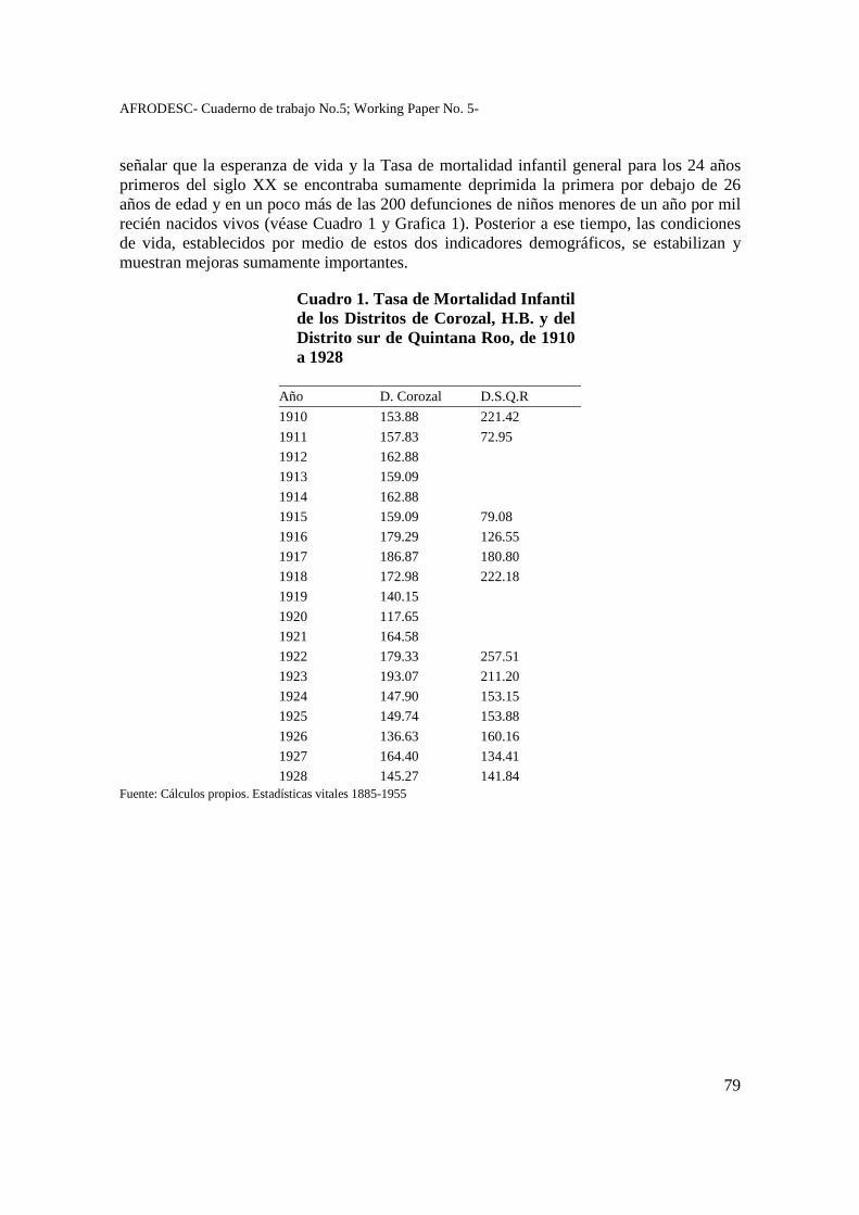
AFRODESC- Cuaderno de trabajo No.5; Working Paper No. 5-
79
señalar que la esperanza de vida y la Tasa de mortalidad infantil general para los 24 años primeros del siglo XX se encontraba sumamente deprimida la primera por debajo de 26 años de edad y en un poco más de las 200 defunciones de niños menores de un año por mil recién nacidos vivos (véase Cuadro 1 y Grafica 1). Posterior a ese tiempo, las condiciones de vida, establecidos por medio de estos dos indicadores demográficos, se estabilizan y muestran mejoras sumamente importantes.
Cuadro 1. Tasa de Mortalidad Infantil de los Distritos de Corozal, H.B. y del Distrito sur de Quintana Roo, de 1910 a 1928
Año D. Corozal D.S.Q.R
1910 153.88 221.42
1911 157.83 72.95
1912 162.88
1913 159.09
1914 162.88
1915 159.09 79.08
1916 179.29 126.55
1917 186.87 180.80
1918 172.98 222.18
1919 140.15
1920 117.65
1921 164.58
1922 179.33 257.51
1923 193.07 211.20
1924 147.90 153.15
1925 149.74 153.88
1926 136.63 160.16
1927 164.40 134.41
1928 145.27 141.84 Fuente: Cálculos propios. Estadísticas vitales 1885-1955
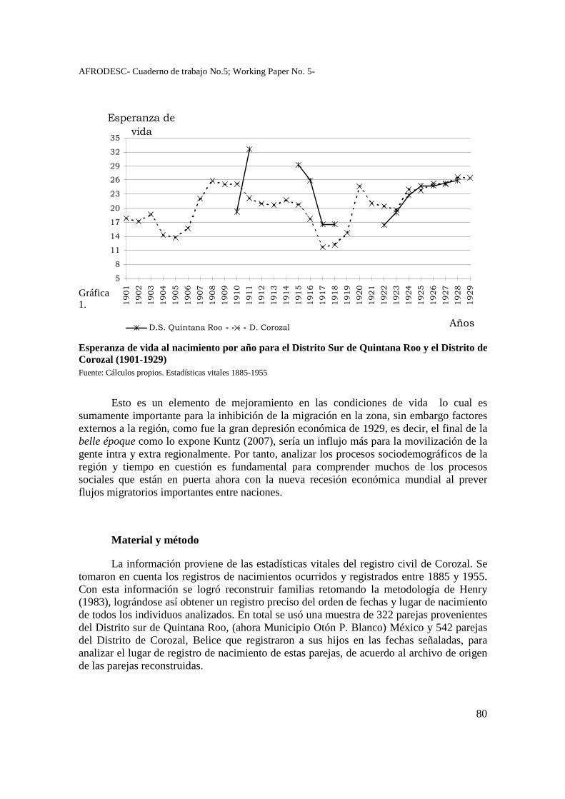
AFRODESC- Cuaderno de trabajo No.5; Working Paper No. 5-
80
Gráfica 1.
Esperanza de vida al nacimiento por año para el Distrito Sur de Quintana Roo y el Distrito de Corozal (1901-1929) Fuente: Cálculos propios. Estadísticas vitales 1885-1955
Esto es un elemento de mejoramiento en las condiciones de vida lo cual es sumamente importante para la inhibición de la migración en la zona, sin embargo factores externos a la región, como fue la gran depresión económica de 1929, es decir, el final de la belle époque como lo expone Kuntz (2007), sería un influjo más para la movilización de la gente intra y extra regionalmente. Por tanto, analizar los procesos sociodemográficos de la región y tiempo en cuestión es fundamental para comprender muchos de los procesos sociales que están en puerta ahora con la nueva recesión económica mundial al prever flujos migratorios importantes entre naciones.
Material y método
La información proviene de las estadísticas vitales del registro civil de Corozal. Se tomaron en cuenta los registros de nacimientos ocurridos y registrados entre 1885 y 1955. Con esta información se logró reconstruir familias retomando la metodología de Henry (1983), lográndose así obtener un registro preciso del orden de fechas y lugar de nacimiento de todos los individuos analizados. En total se usó una muestra de 322 parejas provenientes del Distrito sur de Quintana Roo, (ahora Municipio Otón P. Blanco) México y 542 parejas del Distrito de Corozal, Belice que registraron a sus hijos en las fechas señaladas, para analizar el lugar de registro de nacimiento de estas parejas, de acuerdo al archivo de origen de las parejas reconstruidas.
�
�
��
��
��
��
��
�
�
��
��
���
���
���
���
���
��
���
���
��
���
���
���
���
���
���
��
���
���
��
���
���
���
���
���
���
��
���
���
��
�� �
�������������
����
�������������� ���! � ��"
AFRODESC- Cuaderno de trabajo No.5; Working Paper No. 5-
81
Estas parejas se clasificaron por grupos sociales denominados aquí como culturas íntimas, concepto retomado de Lomnitz-Adler (1995), siendo por tanto estas la cultura íntima Dominante2, Emergente3 y Residuales (A y B).4 Una vez clasificadas, se observó el comportamiento de registro de los nacimientos a manera global de 1900 a 1935, así como diacrónicamente, dividiendo el tiempo en tres grandes grupos, 1871-1914, 1915-1924 y 1925-1959, de acuerdo a la fecha de nacimiento del primogénito es decir, la primera etapa, donde se espera un gran movimiento poblacional a ambos lados de la frontera gracias a que están en formación las primeras comunidades; recuérdese que el Territorio Federal de Quintana Roo se crea en 1902 y hasta 1914 el gobierno federal establece en él un verdadero recinto militar para congregar a los opositores al régimen de poder en turno (Macías Richard, 1997). La segunda etapa es la etapa revolucionaria de México y en ésta hubo un sin número de cambios de poder en el Territorio de Quintana Roo, lo que promovió una serie de cambios en la sociedad y migraciones entre ambas fronteras. Por último, la etapa de 1925-1959, cruza desde una era de relativa estabilización política y económica en la región hasta el crack económico de 1929 lo cual hizo que fuera uno de los grandes motores de la migración intra regionalmente, en búsqueda de nuevas fuentes de empleo.
En la presente ponencia se presentan tablas de contingencia de los datos señalados, con información a ambos lados de la frontera a manera de poder comparar los resultados de aquellos beliceños que retornaban a sus lugares de origen frente a los demás integrantes de la sociedad de Quintana Roo, para poder establecer así sus características de acuerdo a su clasificación por cultura íntima.
Resultados
Cuando se analiza el lugar de registro de nacimientos de las parejas por cultura íntima y de acuerdo al archivo de origen de las parejas reconstruidas (Cuadro 2) se observa que las parejas dominantes sólo registraban a sus hijos del lado de la frontera donde vivían. Mientras que para los integrantes de las demás culturas íntimas había una “mayor” movilidad a lo largo de la frontera en cuanto al registro de sus nacimientos, a pesar de que lo cotidiano era registrar los hechos vitales en un sólo lado de la frontera, dado los altos
2 Compuesto por personas con apellidos, español, anglosajón y árabe, siendo la ocupación del padre comerciantes, militares de alto rango, trabajadores no manuales de compañías chicleras y madereras, las madres, dedicadas tanto a labores del hogar, o bien artesanas o profesionistas, y el padre de la madre comerciantes. 3 Compuesto por personas con apellidos español, anglosajón, indígena maya, siendo la ocupación del padre empleados públicos, trabajadores prestadores de servicios personales, comerciantes, artesanos y profesionistas, las madres, dedicadas tanto a labores del hogar, o bien artesanas o profesionistas, y el padre de la madre trabajadores manuales y comerciantes. 4 Compuesto por personas con apellidos español, indígena maya, anglosajón, otro siendo la ocupación del padre campesinos, trabajadores dedicados a actividades primarias, trabajadores manuales, comerciantes, y trabajadores de la madera y el chicle, las madres, dedicadas tanto a labores del hogar, o bien campesinas, trabajadoras dedicadas a actividades primarias, trabajadoras manuales, y el padre de la madre campesinos, trabajadores dedicados a actividades primarias, trabajadores manuales, comerciantes, y trabajadores de la madera y el chicle. El residual B es sólo la madre con información referente a su apellido (español e indígena maya).
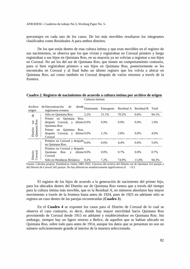
AFRODESC- Cuaderno de trabajo No.5; Working Paper No. 5-
82
porcentajes en cada uno de los casos. De los más movibles resultaron los integrantes clasificados como Residuales A para ambos distritos.
De los que están dentro de esta cultura íntima y que eran movibles en el registro de sus nacimientos, se observa que los que vivían y registraban en Corozal primero y luego registraban a sus hijos en Quintana Roo, en su mayoría ya no volvían a registrar a sus hijos en Corozal. No así los del sur de Quintana Roo, que tienen un comportamiento contrario, pues si bien registraban primero a sus hijos en Quintana Roo, posteriormente se les encontraba en Corozal y al final hubo un último registro que los volvía a ubicar en Quintana Roo, así como también en Corozal después de varios retornos a través de la frontera.
Cuadro 2. Registro de nacimientos de acuerdo a cultura íntima por archivo de origen
Culturas íntimas
Archivo de origen
Sincronización de donde registraron eventos
Dominante Emergente Residual A Residual B Total
Sólo en Quintana Roo 2.2% 21.1% 70.2% 0.6% 94.1% Primer en Quintana Roo, después Corozal, y último Quintana Roo
0.0% 0.9% 0.9% 0.0% 1.9%
Dis
trito
su
r de
Q
uint
ana
Roo
Primer en Quintana Roo, después Corozal, y último Corozal
0.0% 1.2% 2.8% 0.0% 4.0%
Primero en Corozal y después en Quintana Roo
0.0% 0.6% 4.4% 0.0% 5.0%
Primero en Corozal y después Quintana Roo y último Corozal
0.0% 0.0% 0.7% 0.0% 0.7%
Dis
trito
C
oroz
al
Sólo en Honduras Británica 0.2% 7.2% 74.9% 11.8% 94.3% Fuente: Cálculos propios. Estadísticas vitales 1885-1955. Universo del archivo del Distrito sur de Quintana 322 parejas y del Distrito de Corozal 542 parejas. No hay diferencias estadísticamente significativas al � > 0.5
El registro de los hijos de acuerdo a la generación de nacimiento del primer hijo, para los ubicados dentro del Distrito sur de Quintana Roo vemos que a través del tiempo para la cultura íntima más movible, que es la Residual A, en números absolutos hay mayor movimiento a través de la frontera hasta antes de 1924, pues de 1925 en adelante sólo se registra un caso dentro de las parejas reconstruidas (Cuadro 3).
En el Cuadro 4 se exponen los casos para el Distrito de Corozal de lo cual se observa el caso contrario, es decir, donde hay mayor movilidad hacia Quintana Roo proviniendo de Corozal desde 1915 en adelante y estableciéndose en Quintana Roo. Sin embargo, siempre hay un ligero retorno a Belice, de aquellos que se habían ubicado en Quintana Roo, sobre todo para antes de 1914, aunque los datos que se presentan no son un número suficientemente grande al interior de la muestra seleccionada.
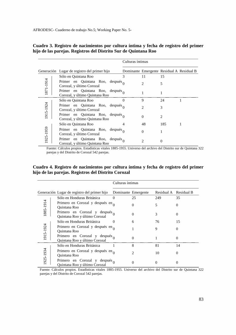
AFRODESC- Cuaderno de trabajo No.5; Working Paper No. 5-
83
Cuadro 3. Registro de nacimientos por cultura íntima y fecha de registro del primer hijo de las parejas. Registros del Distrito Sur de Quintana Roo
Culturas íntimas
Generación Lugar de registro del primer hijo Dominante Emergente Residual A Residual B
Sólo en Quintana Roo 3 11 15 Primer en Quintana Roo, después Corozal, y último Corozal
0 2 5
187
1-1
914
Primer en Quintana Roo, después Corozal, y último Quintana Roo
0 1 1
Sólo en Quintana Roo 0 9 24 1 Primer en Quintana Roo, después Corozal, y último Corozal
0 2 3
191
5-1
924
Primer en Quintana Roo, después Corozal, y último Quintana Roo
0 0 2
Sólo en Quintana Roo 4 48 185 1 Primer en Quintana Roo, después Corozal, y último Corozal
0 0 1
192
5-1
959
Primer en Quintana Roo, después Corozal, y último Quintana Roo
0 2 0
Fuente: Cálculos propios. Estadísticas vitales 1885-1955. Universo del archivo del Distrito sur de Quintana 322 parejas y del Distrito de Corozal 542 parejas.
Cuadro 4. Registro de nacimientos por cultura íntima y fecha de registro del primer hijo de las parejas. Registros del Distrito Corozal
Culturas íntimas
Generación Lugar de registro del primer hijo Dominante Emergente Residual A Residual B
Sólo en Honduras Británica 0 25 249 35 Primero en Corozal y después en Quintana Roo
0 0 5 0
188
5-1
914
Primero en Corozal y después Quintana Roo y último Corozal
0 0 3 0
Sólo en Honduras Británica 0 6 76 15 Primero en Corozal y después en Quintana Roo
0 1 9 0
1915
-192
4
Primero en Corozal y después Quintana Roo y último Corozal
0 0 1 0
Sólo en Honduras Británica 1 8 81 14 Primero en Corozal y después en Quintana Roo
0 2 10 0
1925
-193
4
Primero en Corozal y después Quintana Roo y último Corozal
0 0 0 0
Fuente: Cálculos propios. Estadísticas vitales 1885-1955. Universo del archivo del Distrito sur de Quintana 322 parejas y del Distrito de Corozal 542 parejas.
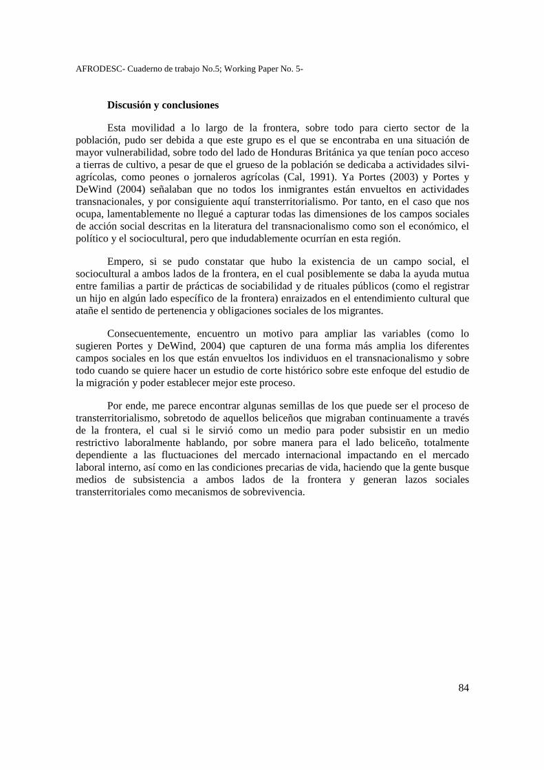
AFRODESC- Cuaderno de trabajo No.5; Working Paper No. 5-
84
Discusión y conclusiones
Esta movilidad a lo largo de la frontera, sobre todo para cierto sector de la población, pudo ser debida a que este grupo es el que se encontraba en una situación de mayor vulnerabilidad, sobre todo del lado de Honduras Británica ya que tenían poco acceso a tierras de cultivo, a pesar de que el grueso de la población se dedicaba a actividades silvi-agrícolas, como peones o jornaleros agrícolas (Cal, 1991). Ya Portes (2003) y Portes y DeWind (2004) señalaban que no todos los inmigrantes están envueltos en actividades transnacionales, y por consiguiente aquí transterritorialismo. Por tanto, en el caso que nos ocupa, lamentablemente no llegué a capturar todas las dimensiones de los campos sociales de acción social descritas en la literatura del transnacionalismo como son el económico, el político y el sociocultural, pero que indudablemente ocurrían en esta región.
Empero, si se pudo constatar que hubo la existencia de un campo social, el sociocultural a ambos lados de la frontera, en el cual posiblemente se daba la ayuda mutua entre familias a partir de prácticas de sociabilidad y de rituales públicos (como el registrar un hijo en algún lado específico de la frontera) enraizados en el entendimiento cultural que atañe el sentido de pertenencia y obligaciones sociales de los migrantes.
Consecuentemente, encuentro un motivo para ampliar las variables (como lo sugieren Portes y DeWind, 2004) que capturen de una forma más amplia los diferentes campos sociales en los que están envueltos los individuos en el transnacionalismo y sobre todo cuando se quiere hacer un estudio de corte histórico sobre este enfoque del estudio de la migración y poder establecer mejor este proceso.
Por ende, me parece encontrar algunas semillas de los que puede ser el proceso de transterritorialismo, sobretodo de aquellos beliceños que migraban continuamente a través de la frontera, el cual si le sirvió como un medio para poder subsistir en un medio restrictivo laboralmente hablando, por sobre manera para el lado beliceño, totalmente dependiente a las fluctuaciones del mercado internacional impactando en el mercado laboral interno, así como en las condiciones precarias de vida, haciendo que la gente busque medios de subsistencia a ambos lados de la frontera y generan lazos sociales transterritoriales como mecanismos de sobrevivencia.
AFRODESC- Cuaderno de trabajo No.5; Working Paper No. 5-
85
Bibliografía
Cal Rosado, Angel Eduardo (1991), “Capital-labor relations on a colonial frontier: nineteenth-century northern Belize”, en: Brannon, Jeffery T. y Gilberth M. Joseph (eds), Land, labor, and capital in modern Yucatán. Essays in regional history and political economic, The University of Alabama Press, Tuscaloosa, Alabama, p. 83-106.
Gledhill, John (1999), “El reto de la globalización: reconstrucción de identidades, formas de vida transnacionales y las ciencias sociales”, en: Mummert, Gail, Fronteras fragmentadas, El Colegio de Michoacán, CIDE, Zamora, Michoacán, pp. 23-54.
Henry, Louis (1983), Manual de demografía histórica, Editorial Crítica, Barcelona, España.
Kearny, Michael (1996), Reconceptualizing the peasantry: anthropology in global perspective, Westview, Boulder.
Kuntz Ficker, Sandra (2007), El comercio exterior de México en la era del capitalismo liberal, 1870-1929, El Colegio de México, México.
Lomnitz-Adler, Claudio (1995), Las salidas del laberinto. Cultura e ideología en el espacio nacional mexicano, Joaquín Mortiz, Planeta, México.
Macías Richard, Carlos (1997), Nueva frontera mexicana: milicia, burocracia y ocupación territorial en Quintana Roo (1902-1927), Colección Sociedad y Cultura en la Vida de Quintana Roo III, Consejo Nacional de Ciencia y Tecnología, Universidad de Quintana Roo, México.
Ortega Muñoz, Allan (2006), "Cultura regional: un marco teórico para el estudio del proceso de transterritorialismo en los asentamientos de la región Quintana Roo-Honduras Británica (Belice), 1900-1935", en: González, José Luis y Franco Savarino, Intinerarios. Cultura, memoria e identidades en América Latina y El Caribe, Instituto Nacional de Antropología e Historia, Escuela Nacional de Antropología e Historia, México, pp. 175-199.
Ortega Muñoz Allan, (2008) Una frontera en movimiento. Migración, fecundidad e identidad del sur de Quintana Roo y norte de Honduras Británica (Belice), 1900-1935, Tesis de doctorado en Estudios de Población, El Colegio de México, México.
AFRODESC- Cuaderno de trabajo No.5; Working Paper No. 5-
86
Portes, Alejandro (2003), “Conclusion: Theoretical convergencies and empirical evidence in the study of immigrant transnationalism”, International Migration Review, 37(3): 874-892.
__________ y Josh DeWind (2004), “A cross-Atlantic dialogue: the progress of research and theory in the study of international migration”, International Migration Review, 38(3): 828-851 .
Rex, John (2003), “Elementos esenciales de una teoría sistemática de las relaciones étnicas”, Estudios Sociológicos, XXI(62): 243-277
AFRODESC- Cuaderno de trabajo No.5; Working Paper No. 5-
87
Transmission of Rights to House Lots in Barranco, a Garifuna village in Southern Belize 1895 to 2000. – lessons in Caribbean
Ethnohistory
JOSEPH O. PALACIO, Judy LUMB, Carlson TUTTLE University of the West Indies School
[email protected] Belize
Summary Studies have shown that as in other British colonies in the Caribbean, monopoly control over land and labour persisted throughout the post-emancipation era in Belize continuing throughout most of the nineteenth century. Studies on the landless non-British minorities, however, have been limited almost exclusively to the Maya fleeing either from Mexico as Caste War refugees or forced labour from Guatemala. These studies have overlooked the Garifuna, who were also looking for their own refuge and in doing so established footholds for communities mainly in Southern Belize. While being black like the larger population of African ex-slaves in Belize, the Garifuna maintained strong ties to extended kinship as well as to the land and sea as intrinsic components of their nationhood, which had congealed in South America and the Eastern Caribbean over centuries. Initial interactions of the Garifuna with British authorities on rights to house lots within villages, which they had established on land even before the British had assumed full territorial rights from Spain, makes for a backdrop of topics that I cover in this paper under the heading of legalizing lot tenure. They include carrying out a cadastral survey, re-distributing surveyed lots which had already been occupied, and initiating a formalized structure for ownership and its transfer, among others. The study provides detail description and analysis of circumstances being repeated in other communities that were simultaneously undergoing lot ownership 'regularization' in southern Belize. Keywords: tenure, Garifunas, territorial rights
AFRODESC- Cuaderno de trabajo No.5; Working Paper No. 5-
88
Lot Transmission in Barranco 1893-2000 – Ownership and Relations Underlining Succession of Ownership
Introduction
According to the Caribbean Land Policy Network Report, one of the “critical issues” that underlie policy, administration, and management of land in the English Caribbean is “Unofficial land tenure systems are as significant as the legal land tenure system” (Williams 2003: 3). The duality between the formal/legal and non-formal/non-legal systems of tenure found in rural communities across the Caribbean subregion has been much repeated in several studies (Besson 2002, Carnegie 1987, Greenfield 1960: 165-176, and Williams 2003). This study is also on how members of a rural community combine traditional customary practices with government land administration protocol but it differs from those found in the literature in the following ways: 1) this study is on house lot tenure and not on homesteads or farmlands, topics that dominate land tenure research within the region; 2) unlike most studies that focus on African-derived groups after emancipation, this study is on the Garifuna, an Afro-Caribbean indigenous people, who having been defeated and exiled from their homeland in the Eastern Caribbean in 1797, self-settled in several communities along the Caribbean coast of Central America1 following their maroon sociocultural formation in the Eastern Caribbean.
Other points of departure for us are the sources of information we used and the length of time spent collecting them. We use as primary data official lot transmission records lasting 107 years from 1893 to 2000; genealogical data originating from church and government archives; and oral interviews that we have collected in the same community for over thirty years. From this battery of sources we have been able to identify what customary practices the villagers have used in claiming lot ownership while abiding by the government land administration system. Besides, we have been able to place the significance of kinship and gender as cultural co-ordinates of lot transmission.
Conceptually, this study borrows from what has been uncovered on land tenure in the Caribbean and on the Garifuna people in Central America. From the Caribbean we highlight kinship, more especially bilateral kinship descent, as a primary medium of lot transmission. From Garifuna studies we refer to research on their settlement practice as moving to form a stretch of ubiabarei (small hamlets inhabited by one or more family groups)2 along the coast of Central America from Honduras to Belize (Arrivillaga 2005: 64-84, Davidson (1976: 85-94) and 1984: 13-36), and Gonzalez (1987: 51-73). The ever changing fortunes of these settlements could result in their demise or growth. By and large, 1 The differential experiences between the Garifuna and other blacks within the sugar plantation as pivot of Caribbean colonial history is crystallized by Mintz (1989:146-156). Mintz places the blacks in larger islands like Jamaica and Haiti into a “proto-peasantry” group, “who have developed a peasant-like adaptation within the plantation” (Besson 2002:7). On the other hand, the Garifuna would fit into his “runaway peasantries” group, “who established virtually autonomous communities in almost inaccessible terrain during the entire slavery period throughout African America” (Besson 2002: 7) 2 Gonzalez (1988: 61) refers to this process as establishing ‘beachheads’.
AFRODESC- Cuaderno de trabajo No.5; Working Paper No. 5-
89
they were communities made up of family groups living in contiguous blocks of residential land. Family members moved freely from one to the other, where they were welcome to form their own households on lands belonging to their extended families. Villages, therefore, have always been simultaneously sending and receiving kinfolk to and from adjoining locations that may even be in different countries.
Located in the extreme southeastern part of Belize, our study community of Barranco escaped the full brunt of the British colonial land administration system felt more in central and western parts of Belize caught under the complete influence of mahogany exploitation. However, the village was very much a part of the overall colonial design to discourage non-whites from settling; and at best to allow them to live on public lands – either as Indian/Carib reserves or on lease land – and remain there permanently while being available as cheap labour. The land administration system currently in place in the Toledo District, which includes Barranco, has its origins in the exclusionary basis that prevailed up to the 1960s, the beginning period of the nationalist movement leading to political independence.
The main contribution of the study comes from a narrative of the data, its analysis, and the summary of the results. These come alive through several tables depicting a wide array of kinship and gender relations that demonstrate how lot transmission is embedded in traditional cultural practices, which have shaped the Garifuna nation as we know it today in coastal Central America. The Setting – locality and research methods
Among the seven traditional Garifuna communities in southern Belize, Barranco is probably the only one that was certainly not on privately held land when it was first settled around the mid-1800s. Neither was it ever declared a Carib Reserve. The pioneers themselves were probably not aware of the unique availability of this bit of coastal land along a stretch that was in high demand for plantation agriculture3. What immediately caught their attention were the ample lands for their bush gardens, the abundant seafood, and a well-drained site to build their houses. Indeed, they were reconnoitering for such a location having been pushed away by political violence and whites, who chased them from their cultivations, according to oral tradition, in the area of Jonathan Point, Stann Creek District. They came from as far north as Dangriga and south in neigbouring Livingston. Their respective places of origin placed the village within a subregion in the larger Gulf of Honduras as shown in Fig. 1.
3 After the 1850s the British efforts to spur estate agriculture as the new economic lifeline to replace mahogany led to the sale of several large blocks of public lands along the southern coast and riverways (Bolland and Shoman 1977: 58-101 and Wright et al. 1959: 110-123)
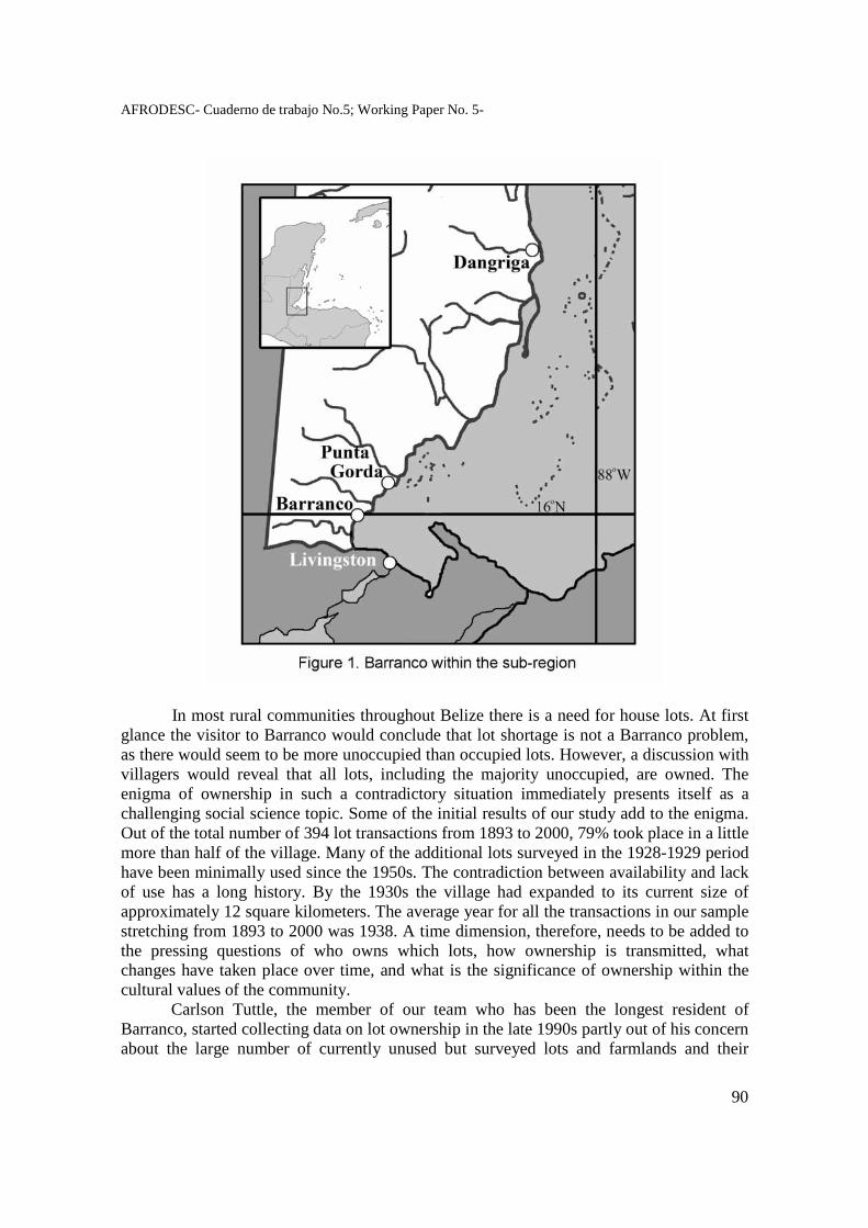
AFRODESC- Cuaderno de trabajo No.5; Working Paper No. 5-
90
In most rural communities throughout Belize there is a need for house lots. At first glance the visitor to Barranco would conclude that lot shortage is not a Barranco problem, as there would seem to be more unoccupied than occupied lots. However, a discussion with villagers would reveal that all lots, including the majority unoccupied, are owned. The enigma of ownership in such a contradictory situation immediately presents itself as a challenging social science topic. Some of the initial results of our study add to the enigma. Out of the total number of 394 lot transactions from 1893 to 2000, 79% took place in a little more than half of the village. Many of the additional lots surveyed in the 1928-1929 period have been minimally used since the 1950s. The contradiction between availability and lack of use has a long history. By the 1930s the village had expanded to its current size of approximately 12 square kilometers. The average year for all the transactions in our sample stretching from 1893 to 2000 was 1938. A time dimension, therefore, needs to be added to the pressing questions of who owns which lots, how ownership is transmitted, what changes have taken place over time, and what is the significance of ownership within the cultural values of the community. Carlson Tuttle, the member of our team who has been the longest resident of Barranco, started collecting data on lot ownership in the late 1990s partly out of his concern about the large number of currently unused but surveyed lots and farmlands and their
AFRODESC- Cuaderno de trabajo No.5; Working Paper No. 5-
91
impact on the future development of the village. From the village he deepened his data collection to include the Department of Lands archives in Punta Gorda and Belmopan as well as the Archives Department also in Belmopan. Archival collection of a related source, namely genealogies, proved to be another invaluable resource. They came from the collections of Tuttle and Joseph Palacio, another member of our team. A third member, Judy Lumb, assisted with research in published and unpublished documents together with details on database management and publication. During the almost decade in which fieldwork for this study was taking place, it became increasingly difficult to draw lines across our individual contributions. It has truly been a collaborative effort going across academic disciplines, research habits, and our special interests. Our team meetings, held in the village when possible, provided much needed inspiration and support.4 As the wealth of the gradually accumulating field data dawned on us, we developed methods for electronic input to facilitate retrieval and analysis. The first spreadsheets included all the records on each lot in the village. These records featured lot number, owner, dates of lease approval and number, together with the dates of cancellation, expiry, being voided, etc. There were other bits of administrative information on some lots. In Appendix 1 there is a page from the spreadsheet showing the comprehensive nature of the details collected and digitized. A study of these spreadsheets led us to the conclusion that there was embedded in them much material for several kinds of analysis. We arrived at one broad type that would focus on the following primary variables – the kinship relations between persons involved in each transaction and the gender of each one. This framework fits into the larger social history of land use in Barranco that evolved as our main study topic as a team. Bringing about this change meant creating a database in Microsoft Access to better accommodate the data and analysis. The strength of any database is the units selected to be fields and records. We made each transaction a record and identified 13 fields described in Table 2. We isolated the introduction of a new name among the owners of each lot as a transaction between donor and recipient. Identifying whether there was any kinship tie between the donor and recipient and what it was exactly were two tasks that tested our extensive knowledge of village genealogy. We had to overcome other obstacles, such as kinds of descent relations and degrees of distance in consanguineal and affinal relations. As we go into greater details further below on the specifics of the database, we will explain how we overcame these hurdles to be able to design the database. The methods of analysis we used after finishing the database were Microsoft Access filter and sort functions with queries. From the perspective of overall research orientation, this study has grown from an incremental and inductive framework. At the outset we were not certain where the results of our fieldwork would carry us. Our grounding in sociological methodology and awareness of similar research investigations within the region and beyond helped us to draw from the rich data at our disposal.
4 We are indebted to several persons who have helped. They include Hervan Morgan, Joshua Richards, Marion Cayetano, staff at the Lands Department in Punta Gorda and Belmopan and at the Archives Department in Belmopan. Finally, we are indebted to our fellow Barranguna, who have provided so much information and other kinds of support.
AFRODESC- Cuaderno de trabajo No.5; Working Paper No. 5-
92
House Lot Tenure – the Caribbean and the Garifuna The house lot has received minimal attention among the students of land tenure within the larger English-speaking Caribbean. On the other hand, the main focus has been on the homestead, a combination of indoor space for residence and adjoining outdoors for intensive farming. The homestead is referred to as ‘house plot’, ‘residence site’, ‘yard’, among other words in the vernacular. The term ‘house lot’ is usually limited for the unit of domestic space found in towns, where, as in Barranco, it is demarcated by certified surveyors and isolated as a stand-alone unit according to national laws. Because of the primacy of continuing blood ties as being interwoven into land rights, the study of homestead transmission is built into the larger topic of kinship obligations, a major topic of scholarly concern within the Caribbean. The daily livelihood of the family takes place within the confines of the homestead. There they produce to sell at the town or regional market using store-bought inputs within the prototypical peasant small-scale production system found throughout the rural Caribbean. The day to day economic function of the homestead, however, dwarfs its symbolic value as the unit of land that ancestors received at emancipation forever separating their domestic sanctuary from the slave quarters of the plantation. Attaining freedom became concretized in the freehold possession of the homestead together with the right to pass it from one generation to the next, with all descendants – male or female – sharing equal access among their siblings. The regional framework that we have so far outlined takes various formats as can be seen in the detail reviews done by Besson (2002) and Rubenstein (1987), among several others. With only a few deviations, most of the studies are done within periods of a few months using information collected from informants. The thrust, therefore, is synchronic describing inheritance done within the period of study. From these examples ethnographers have assumed what customary practices had been over time. Two longitudinal studies done by M. G. Smith (1956) and Jean Besson (2002) provide an extensive time-frame comparable to that in our study of lot transmission in Barranco. M.G. Smith found out that rural folk in Carriacou, Grenada obtained freehold titles to their homesteads but transmitted them partly through non-legal customary practices based on traditional patrilineages. Jean Besson, on the other hand, identified bilateral (i.e. through one’s mother and father) family ties as intermediary for transmission in her study of Trelawny, Jamaica. Bilateral kin ties have been found to predominate throughout the Caribbean. Indeed, the deliberate passing of land through bilateral kin ties, from one generation to the next, has provided a point of reference to Gonzalez (1969) in analyzing her data from her seminal study in Livingston, Guatemala in 1958. In her subsequent paper entitled “Non-unilineal Descent Groups in Central America and the Caribbean”, she concluded “All children regardless of sex or birth order, inherit equally from both parents, although favouritism, the child’s behavior and certain other factors may affect the actual distribution of property” (1965: 12). She adds, “… inheritable property includes money, residence sites in town, buildings, tools, and in some cases, cultivable land”. From Gonzalez’s reference on bilateral descent and inheritance, Helms and Loveland made a leap to the assertion of the Garifuna being “property-controlling descent groups” (1976:151). The description of the Garifuna as “property-controlling descent groups” is not supported by our data on lot tenure in Barranco. Rather, the use of the term “property-
AFRODESC- Cuaderno de trabajo No.5; Working Paper No. 5-
93
controlling descent group” is applicable only in the sense of the villagers’ use of halati wafamilia (our family lot), meaning that given families have owned lots for generations. The scrutiny that we have been able to apply to transmissions clarifies this assertion in Garifuna folk wisdom as well as the casual use of the term “bilateral descent” in the Caribbean by Besson (2003). Donors transmit lots to recipients through consanguineal and affinal ties. Consanguineal ties are further subdivided between immediate family relations and descent, as shown in Chart 1. The relationship between a donor and recipient may derive through siblingship or through ties from one’s father or mother. In Chart 1 ‘uterine’ stands for mother and ‘male’ for father. The frequencies for sibling are the least at 8, while males (59) supersede uterine (56) by only three. These numbers confirm that under the immediate family subgroup of the consanguineal bond, bilateral ties are almost equally split between one’s father and mother.
Having deducted the eight cases under sibling transmission, we moved from the range of immediate family ties to differentiation by descent, which falls under lineal and non-lineal linkages. Lineal ties flow through the direct lines of one’s grandfather, to father and to oneself. Descent, however, can be deguéguati (literally divided into two parts), a close English translation would be “bifurcated”. In anthropology the term is collateral kin or non-lineal descent, which is traced from one’s granduncle, to one’s uncle, to oneself. In our database, lineal descent (76) occurs slightly more than twice the non-lineal (39). The distinction between the two is especially important in bringing forward the significance of cousins, whose role in lot transmission we will discuss further below. The distinction between lineal and collateral kinship systems together with their influence on behaviour is discussed in Schusky (1983: 14-15).
AFRODESC- Cuaderno de trabajo No.5; Working Paper No. 5-
94
Chart 1
Consanguineal and Affinal Relations Underlying Lot Transactions Consanguineal Relations Immediate Family Frequency % Sibling 8 6 Uterine 56 46 Male 59 48 Total 123 100 Descent Frequency % Non-Lineal 39 34 Lineal 76 76 Total 115 100 Affinal Relations Gender Frequency % Female 32 63 Male 29 47 Total 61 100 Apart from blood or consanguineal ties, donors use in-law or affinal ties to determine to whom to give a lot. There are far more consanguineal (123) than affinal (61). Affinal relations derive through gender – male (29) and female (32). In the former the tie is through a male, as, for example, a man giving a lot to his son’s wife is doing so through the intermediary of a male, i.e. his son. The opposite, a woman giving a lot to her son-in-law, is an example of a woman (namely her daughter) being an intermediary. In terms of the literature on land tenure in the Caribbean this study shows some marked departures. Firstly, the house lot is the unit of use in Barranco and not the homestead. Secondly, most of the village lots are leasehold while in the Caribbean they are freehold (i.e. bought land). Thirdly, the transmission displays a complexity that cannot be simplified under the commonly assumed context of bilateral descent. Together with consanguineality, affinality is a significant determinant of lot transmission; so also is the gender of both the donor and recipient, as we shall see further below. The one common characteristic that Barranguna (in Garifuna the residents of Barranco and those in the diaspora who call Barranco their home) share with some of their Caribbean counterparts on land rights is respect to the ancestors as ultimate source. In the Caribbean the ancestors are personalized as the first men and women who received the land
AFRODESC- Cuaderno de trabajo No.5; Working Paper No. 5-
95
at emancipation and are integrated within an “active spirit world” (Besson 2002: 30). For the Barranguna the ancestors are represented as spirits who died two or more generations earlier but maintain mystical connections between their descendants and ancestors, who first landed in Central America on being exiled from St. Vincent (Foster 2005: 89). Their significance might not be directly related to the land rights of the living but to the larger identity of the Garifuna as a nation forced to live in communities traditionally isolated and dispersed across several nation states. The land transmission system that the Garifuna have evolved over time becomes in itself an important pathway to understand how they continue to form not only their communities but also their nationhood. The related topics of settlement, community, and land administration bridge the gap between the larger Caribbean and the Garifuna people as we see in the following section of this paper. Settlement, Community, and Land Administration The foremost student of Garifuna cultural geography, W.V. Davidson, speaks of the “Garifuna realm” as dominating “the rural landscape of the Caribbean littoral for 400 miles – central Belize to eastern Honduras” (1986: 20). While this may have been so in the 1970s around the time when Davidson made his observations, by the early 21st century the rural landscape of coastal Central America has changed considerably from the intrusion of agro-industries, shrimp aquaculture, and tourism infrastructure - all bringing in their wake hundreds of Ladino and Maya Q’eqchi settlers and workers. The numerical predominance of Garifuna as an ethnic group has reduced in communities in southern coastal Belize; and so has been the case, according to my casual observations, in neigbouring parts of Guatemala and Honduras. Ironically, while the physical and ethnic landscapes have changed, the Garifuna awareness of their realm has become stronger, in a manner more than nostalgic, in terms of re-discovering, where they have lived as a people for several generations. The re-birth has been fortified by influential leaders, cultural organizations, institutions, some with support from the state and multilateral organizations, such as the United Nations and Inter-American Development Bank, and return migrants from the United States. After the massive celebrations of the 200th anniversary of the first arrival in Central America in 1997, the host governments in Honduras and Guatemala have joined Belize in setting aside days that commemorate the first arrival of Garifuna people to these shores. Within the last twenty years and with dedication and support, their nation-states have extended more than nominal sociopolitical space to them from Nicaragua to Belize.5 The symbol in the re-generation has been to commemorate first settlement as signaling survival from a most difficult past with hopes for greater acceptance in the future. In Honduras and Guatemala the arrivals being celebrated were the destitute survivals of the massacre in St. Vincent, the wretched twenty-six day crossing from Balliceaux to Roatan from March 17 to April 12, 1797; and their equivocal welcome by the Spanish authorities then stationed in Central America. In Belize, among the first arrivals were the survivors
5 In 2003 the President of Nicaragua convened a summit meeting to give support to the UNESCO 2001 Proclamation on Garifuna culture as world patrimony and to integrate it within the framework of the respective countries. The heads of states represented countries from Central America and the Caribbean. Another indication of recognition is that within recent years the Vice-Ministers of Culture in Guatemala and Honduras have been Garifuna.
AFRODESC- Cuaderno de trabajo No.5; Working Paper No. 5-
96
from the 1832 Spanish/Republican wars, who escaped the avenging reprisals, and furthermore overcame the treacherous crossing over high seas and submerged reefs across the Gulf of Honduras. If the cultural landscape that Davidson described is now more reminiscent of the historic moment in the life of a suffering people, more than ever before the challenge for the social scientist is to revisit how they initially founded communities at given localities and how they have maintained possession over them for generations. Davidson (1976:85-94 and 1986: 13-36) gave a schema of the spread from Roatan to the extremes of their domain in eastern Honduras and central Belize within a period of five years. Collecting oral history from several men and women, Arrivillaga (2005: 64-84) has documented family names assumed to be of founders for respective communities in Guatemala and Honduras. Notwithstanding the time limitations of the data in this study, we can identify arrivals and their early descendants and how the latter attracted others in a form of chain migration that still continues up to this present time. Because our lot records start after 1892, there is a lapse of at least thirty years after the first settlement. The following information about early lot owners, therefore, indicates inter-community movements, a pattern that no doubt existed in the earlier selection of settlements. There were two examples of lot transfers in the late 1890s that clarify very close linkages with communities at the polar ends of the Garifuna domain – Punta Gorda, Belize and Trujillo, Honduras. In 1899 Dominga Paulino received lot No. 71, which had been in the name of her husband Diego Paulino, who died in 1896. Both Diego and Dominga came to the village from Punta Gorda from as early as 1866. Several of their offsprings, however, returned to live permanently in Punta Gorda, forming a linkage of close kinfolk between the two neigbouring communities. The following case shows a man coming, getting married to a villager and subsequently receiving a lot from her. In 1899 Andrea Nicholas transferred the lease to her lot No. 60 to her husband Simon Mejia. The latter had come from Trujillo, according to oral history, to Barranco via Punta Gorda and got married to Andrea in 1896. Simon Mejia’s arrival in Barranco was most probably in search of his relatives, which included finding a potential spouse6. The pattern of cross-cousin prescribed marriages was still customary at that time. And Andrea was no doubt in Simon’s classificatory mother’s brother’s daughter or father’s sister’ daughter relationship. The caveat here is the difficulty to substantiate exact kin ties with the minimal records available to us, especially for arrivals away from Belize. A similar combination of spouse and lot as attractions for arriving men took place in 1917, when Francisco Arzu received lot No. 3 from Catarino Palacio. Francisco came from Livingston around 1910; got married to Patrocina Palacio; and subsequently received a lot from his uncle-in-law Patrocina’s father’s brother Catarino Palacio. Francisco Arzu had a brother or close relative, who also came from Livingston around the same time and married Patrocina’s older sister Eulogia. Oral history adds that both were among ten men escaping to Barranco from political persecution in Guatemala in 1910. These few examples indicate the intense nature of inter-community relations that influenced the settlement of Barranco, cementing the bond of circulatory migration that gained strength in subsequent generations as men and women moved freely in search of 6 The prescription on cross-cousin marriage still existed, according to Gullick, up to the 1900-1945 period (1976:84).
AFRODESC- Cuaderno de trabajo No.5; Working Paper No. 5-
97
better livelihood. The unfolding picture of settlement – integrated into kinship, marriage, and other interpersonal ties – becomes clear as the fundamental right of the Garifuna to call Barranco their home. Of course, the Barranguna found themselves under the umbrage of a colonial authority that became formally consolidated as British territory in 1862. The British claim to sovereignty over what is now Belize, according to Chief Justice Dr. Conteh, is based on settlement and not on conquest (2007:42). The difference between the British and the Garifuna is in the methods in which the British exercised their right to assert political and economic domain over their settlement. Using their advantage as a metropolitan global power, they sought to exercise full political control over the Garifuna and other settlers coming into the country during the latter part of the 19th century. A primary component of Britain’s hegemonic power over her subjects was to make laws on the rights that colonial masters would have over land ownership. Briefly, they instituted a policy designed to monopolize full rights to own land, excluding the non-whites - the Maya, Mestizo, Garifuna, among others. Barnett( 1991), Bolland (1987: 33-76), Bolland and Shoman (1977) and Iyo et al (141-174) have documented how the British used the reservation system and leasehold tenure with the aim of causing the Garifuna and Maya to become landless and to be left on reservations, which remained public property and from where they could be available as cheap labour. This overview has given an historical glimpse of how a Garifuna settlement started; the relegation of its residents to the leasehold form of land tenure; and their conditioning to itinerant wage labour. The basis of the customary rights to land tenure around Barranco was that the Garifuna were the first land occupants during the colonial period and that at the outset they imposed their own form of communal ownership on unoccupied lands (Palacio, Lumb, and Tuttle in press). Secondly, leasehold, which prevails in the village, has its origins in the exclusionary British policy of land tenure. Finally, the leasehold system historically conditioned the Garifuna to leave their communities in search of wage labour and the denial to own land, although they proved repeatedly (see Shoman 1994: 88) that they were producers and marketers of agricultural crops. Formal/Non-formal Interplay in Lot Tenure While we have analysed the question of first rights, we now need to examine the transmission of these rights from one generation to another from 1893 to 2000. We start by pinpointing the gap between people’s accession to lots and the carrying out of land surveys by the government. We follow by a review of the lot administration system and the village community response. Thirdly, we review some socio-cultural information about donors and recipients forthcoming from our database. Finally, we analyse briefly the social significance of lot ownership as a rite of passage for personal maturity in the community. Together all of these demonstrate that customary lot tenure is fully institutionalized within the village culture and that it has co-existed in minimal hostility with the formal land administration system. From the villagers’ perspective the survey of lots is a primary function of the government. In many cases, however, the survey was not carried out to delineate lots for first occupancy but to demarcate what was already occupied, thereby legally validating a
AFRODESC- Cuaderno de trabajo No.5; Working Paper No. 5-
98
priori possession. The first survey done in the village in 1892 was a playing out of this process, where the surveyors demarcated lots on lands that were already owned by the villagers (Palacio, Lumb, and Tuttle in press). After the 1892 survey, the steady movement by villagers to occupy lots before they were surveyed continued throughout the 1900s, with the surveyors always being forced to playing catch-up. For example, for some new lots issued between 1909 and 1914 there was the notation in the official record ‘lot had no number when applied for’ showing that persons were applying before the government had given the appropriate survey number. Additionally there is the distinct possibility that those lots were already occupied by the applicants. In such cases the villagers used the traditional system of having family groups live in blocks of land non-legally, as we had described earlier in Palacio, Lumb, and Tuttle (in press). This practice continued after the 1892 surveyed lots had been exhausted and before the next survey was done in 1928 – 1929. The Palacio family added to lots Nos. 3 and 4, which they already owned, lots Nos. 142 to 145 forming a rectangular block extending southward into what was then unsurveyed residential lands. There is also evidence of a smaller Palacio block westward, including lots Nos. 120 to 123. These are shown in Fig. 2.
Fig. 2 Palacio extension into Unsurveyed Areas
AFRODESC- Cuaderno de trabajo No.5; Working Paper No. 5-
99
If the government attempted to break the block possession of families into individualized lots in the 1892 survey, it was even less successful in breaking the successive transmission of rights into a pattern that was not traditional, although it assumed for itself full legal rights to do so. Almost all of the lots in the village are characterized by the government as leased public lands, where ostensibly, not only the ownership but the timing of ownership has remained the prerogative of the government, and such is stated in all lease approval documents. Instead, the community has arrogated these prerogatives onto itself. The procedures to apply for lots have remained virtually the same since Barranguna first applied for lots after the 1892 survey. Briefly, one fills out an application form to lease a lot, should one not be able to purchase it outright. Because purchasing has meant coming up with cash beyond the means of most villagers, they took the lease option. On approval, the government sends a formal document to the applicant giving him the permission to rent the lot usually for a maximum of twenty years. Subsequently, one has the obligation to pay the rent, which has remained unchanged at $2.50 per year since 1893. The lease approval document is known in Garifuna as ligaradana mua. The lose translation is the ‘paper of the earth’7, an idiomatic expression for entitlement to own land from the Garifuna perspective. In Appendix 2 there is a copy of a lease approval document. The final step toward acquiring full ownership may come years after receiving leasehold rights, when the lessee arranges to have the lot surveyed and he pays the appropriate purchase price to the government. He then receives a deed (also referred to as title) with an official map of the lot. In Barranco there is no word in Garifuna for ‘deed’. In a few cases I have heard the villagers use the English word ‘title’. Because most villagers never reach the point of fully purchasing their lot, the lease approval ligaradana mua is the document with which they are most familiar. This is the document that is highly protected among family memorabilia. Additionally, paying one’s lot rent is a duty that most villagers perform every year to safeguard remaining in possession of their lot. On the death of a lessee, legally the lease reverts to the government, or to use the term in land administration language, it ‘expires’. Expiration in village custom, however, does not mean that ownership reverts to the government. The deceased person might have already selected who should inherit the lease. If not, it goes to a relative, according to a pattern that will be revealed further below in our spotlight on the actual transmissions cases we recorded. What is important for our discussion at this point is that the government has allowed tradition to dictate lot transmission when the lessee dies. A potentially thorny problem in intestacy, which is prevalent in the village, becomes side stepped by government into the arms of family members. Whoever takes over the lot of a deceased person can go to the government to apply for a new lease. In most cases the succession is agreed among immediate family members.
In discussing the above example with a retired lands officer, his nonchalant reply was “It is part of natural law that the family determines who should retain possession in the case of intestacy.” He went further and gave an example where he was pro-active in intruding into a possible transmission because he detected blatant injustice. A person coveted a lot so much that he knew when the lease would expire. Stealthily, he submitted an application for it to the Lands Office. As officer, my informant became concerned and 7 In 1857 a Crown Surveyor referred to the Dangriga ‘Caribs’ calling lease documents “their” papers (Bolland and Shoman 1977:91)
AFRODESC- Cuaderno de trabajo No.5; Working Paper No. 5-
100
brought the matter to the attention of the owner, who immediately paid for an extension. He added that it was policy that in such cases he was to ask the owner whether he wanted an extension before proceeding with an application from another. According to him, not all lands officer would have taken it as a responsibility to intervene in such a case. Intruding at such an interpersonal level gave added work to the lands administrator, who has not only house lots but also farmlands on lease under his responsibility for small villages like Barranco as well as for whole districts. At the district level he has to perform tasks in the field, such as overseeing boundary alignments in disputes among neighbours. In the office he oversees the payment of leases and advises on matters, such as lease application, approval, and extensions. This description is for the current time period, when there has been some streamlining of the bureaucracy. Earlier, during most of the 1900s, it was more haphazard with persons not trained in public lands administration being at the frontline, such as the District Commissioner or his chief clerk8. For Barranco rent payments had to be made in Punta Gorda up to the 1960s after which the village policeman was authorized to collect them. We include information about ownership not through leasehold but freehold, namely the outright purchase of lots, when the lot file would no longer remain within the land administration system as public property. Only 35 out of the 177 lots have reached the final stage of deed purchase. Five were purchased by non-villagers and another five are owned by the Roman Catholic Church, leaving 25 in the hands of Barranguna. Only three of these lots have proceeded from the first buyer to being re-sold to another. In short, market trading in house lots, which has overtaken other Garifuna villages in southern Belize, has not yet reached Barranco. On the other hand, lots have remained at the stage of leasehold with transmission taking place not as closed cash-exchange but in open-ended social relations where kinship plays a primary intermediary role. So far we have spoken of the community as the backbone of customary practices in lot tenure. But we need to answer the question of who made up the community in Barranco throughout the 1900s. From the surnames in our database and our overall familiarity we found that up to 1919 as many as one out of every three persons (37%) involved in lot transactions was non-Garifuna, mainly Ladinos, who had lived in the village with their own families from its early inception. The recurring family names were Vaires, Reyes, Santos, and Cardenas. Their permanent outflow from Barranco became noticeable by 1909 when 22% of all donors were non-Garifuna but only 9% were recipients of lots. After the 1920s barely a handful of non-Garifuna were transmitting lots, which included both Ladinos and Creoles without the family support that earlier Ladinos had. The patterns of transactions that we are describing in this study are, therefore, overwhelmingly Garifuna.
8 At the district level the District Commissioner was the officer responsible for all government transactions. Assisting him was his chief clerk, the one most frequently dealing with the public on matters, such as leases.
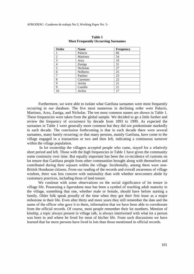
AFRODESC- Cuaderno de trabajo No.5; Working Paper No. 5-
101
Table 1 Most Frequently Occurring Surnames
Order Name Frequency 1 Palacio 66 2 Martinez 54 3 Arzu 33 4 Zuniga 31 5 Nicholas 27 6 Nolberto 25 7 Paulino 23 8 Cayetano 22 9 Ariola 21 9 Castillo 21 10 Avilez 17
Furthermore, we were able to isolate what Garifuna surnames were most frequently occurring in our database. The five most numerous in declining order were Palacio, Martinez, Arzu, Zuniga, and Nicholas. The ten most common names are shown in Table 1. These frequencies were taken from the global sample. We decided to go a little further and review the frequency of occurrence by decade from 1893 to 1999. As expected the surnames in Table 1 were generally more common but they did not predominate markedly in each decade. The conclusion forthcoming is that in each decade there were several surnames, many barely recurring; or that many persons, mainly Garifuna, have come to the village engaged in a transaction or two and then left, indicating a continuous turnover within the village population.
In lot ownership the villagers accepted people who came, stayed for a relatively short period and left. Those with the high frequencies in Table 1 have given the community some continuity over time. But equally important has been the co-incidence of customs on lot tenure that Garifuna people from other communities brought along with themselves and contributed during their sojourn within the village. Incidentally, among them were non-British Honduran citizens. From our reading of the records and overall awareness of village wisdom, there was less concern with nationality than with whether newcomers abide by customary practices, including those of land tenure. We continue with some observations on the social significance of lot tenure in village life. Possessing a ligaradana mua has been a symbol of reaching adult maturity in the village, something that one, whether male or female, should have before starting a family. Older folk speak proudly of the time when they got their first lease as a major milestone in their life. Even after thirty and more years they still remember the date and the name of the officer who gave it to them, information that we have been able to corroborate from the official records. Of course, most people remember their lot numbers. Mention of kinship, a topic always present in village talk, is always intertwined with what lot a person was born in and where he lived for most of his/her life. From such discussions we have learned that far more persons have lived in lots than those mentioned in official records.
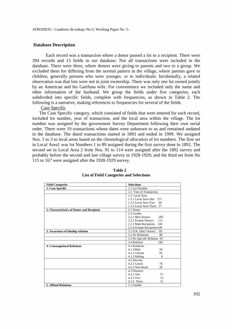
AFRODESC- Cuaderno de trabajo No.5; Working Paper No. 5-
102
Database Description Each record was a transaction where a donor passed a lot to a recipient. There were 394 records and 13 fields in our database. Not all transactions were included in the database. There were three, where donors were giving to parents and two to a group. We excluded them for differing from the normal pattern in the village, where parents gave to children, generally persons who were younger, or to individuals. Incidentally, a related observation was that lots were not in joint ownership. There was only one lot owned jointly by an American and his Garifuna wife. For convenience we included only the name and other information of the husband. We group the fields under five categories, each subdivided into specific fields, complete with frequencies, as shown in Table 2. The following is a narrative, making references to frequencies for several of the fields.
Case Specific The Case Specific category, which consisted of fields that were entered for each record,
included lot number, year of transaction, and the local area within the village. The lot number was assigned by the government Survey Department following their own serial order. There were 19 transactions whose dates were unknown to us and remained undated in the database. The dated transactions started in 1893 and ended in 1999. We assigned Nos. 1 to 3 to local areas based on the chronological allocation of lot numbers. The first set in Local Area1 was lot Numbers 1 to 89 assigned during the first survey done in 1892. The second set in Local Area 2 from Nos. 91 to 114 were assigned after the 1892 survey and probably before the second and last village survey in 1928-1929; and the third set from No 115 to 167 were assigned after the 1928-1929 survey. Table 2
List of Field Categories and Selections
Field Categories Selections 1. Case Specific 1.1 Lot Number 1.2 Year of Transaction 1.3 Local Area
1.3.1 Local Area One 271 1.3.2 Local Area Two 66 1.3.3 Local Area Three 57
2. Characteristics of Donor and Recipient 2.1 Name 2.2 Gender
2.2.1 Men Donors 283 2,2.2 Female Donors 111 2.2.3 Male Recipients 245 2.2.4 Female Recipients149
3. Awareness of kinship relation 3.1 D.K. (don’t know) 69 3.2 No Relations 48 3.3 No Specific Relation 93 3.4 Relation 184 4. Consanguineal Relations 4.1 Relations
4.1.1Male 59 4.1.2 Uterine 56 4.1.3 Sibling 8
4.2 Descent 4.2.1 Lineal 76 4.2.2 Non-lineal 39
4.3 Distance 4.3.1 One 72 4.3.2 Two 13 4.3.3. Three 31
5. Affinal Relations 5.1 Gender
AFRODESC- Cuaderno de trabajo No.5; Working Paper No. 5-
103
5.1.1 Male 29 5.1.2 Female 32
5.2 Distance 5.2.1 One 24 5.2.2 Two 26 5.2.3 Three 11
Characteristics of Donor and Recipient The first two fields under the category ‘Characteristics of Donor and Recipient’ are
name and gender, both of which are self-explanatory. There is a need to explain, however, what we mean by ‘donor’ and ‘recipient’, which will also clarify our use of the term ‘transaction’
The term ‘donor’ does not mean a person handing over a lot at a given time. Pivotal in the definition is the date when the lease went into effect. As this bit of information was not always available, we used instead the year of the lease, which was inserted as part of the lease number, or the year of the lease application. A transaction, therefore, was the succession of rights to the recipient from the donor during a given year. The apparent contradiction occurring when the year of the transaction occurred after the demise of the donor is explained by the time when the recipient received the lease. Earlier there was an explanation of the preeminence in customary practice for families to continue living in the lot, after the death of the person in whose name the lease had been given. The issue of a subsequent lease for the same lot could occur years afterwards.
Awareness of Kinship Relation
Because the kinship relation between the donor and recipient was crucial to our study, we had to arrive at a method that confirmed whether there was any relation between the two persons. The level of awareness, therefore, became the main criterion and this in turn relied on our genealogical record. When we knew that there was definitely a relation, we recorded ‘relation’ numbering 184 in the database. This was the criterion that we used for the database analysis using Microsoft Access, although it accounted for only 47% of the sample.
There were cases when we suspected that there could be some type of relation but were not too sure. For example, the two persons might have had the same surname but we could not securely identify whether they were related. Preferring to err on the side of caution we called such cases ‘No Specific Relation’ or used the abbreviation ‘NSF’ (93). There were cases when we did not know whether there was any kinship tie between the donor and recipient. The transaction might have taken place too long ago or it might have been with a non-Garifuna person. The classification would be ‘D.K.’ for ‘Don’t Know’ (69). The final possibility ‘No Relation’ meant that we were absolutely certain that there was ‘No Relation’. They numbered 48, which was the least among the four possibilities of having/not having a relationship. We were successful in showing that non-kinship relation determined a relatively small proportion of lot transactions.
AFRODESC- Cuaderno de trabajo No.5; Working Paper No. 5-
104
Distance in Consanguineal and Affinal Relations In Table 2 there is a breakdown of subcategories under consanguineal and affinal
relations. We discussed earlier the significance of these subcategories partly to clarify the nebulous use of bilateral descent within the Caribbean literature. Another primary contribution of this study is to diagnose the degrees of distance in consanguineal and affinal relations. The diagnosis results from the extensive time depth of the study coinciding with the distinction in lineal and non-lineal descent by generations between donor and recipient. Figure 3 depicts the sequential flow showing siblings in the second generation, first cousins in the third, and the link between first cousins once removed between the third and fourth generations. The degree of being ‘removed’ among cousins rests on the sequence of generations. Second cousin once removed, for example, would be found between second and third cousins. Very helpful in electronically displaying these degrees of distance was the John Steed’s genealogy software, called Brother’s Keeper. In Table 2 there are frequencies in the occurrence of the three degrees for consanguineal and affinal kin and in Appendix 1, Tables 1 to 4 there are lists under CD1 to CD3 and AD1 to AD3, with CD as abbreviation for Consanguineal Distance and AD, abbreviation for Affinal Distance.
Fig. 3 Kinship Chart
Data Analysis
In the analysis we focus on the succession of lot ownership and on changes in patterns of ownership over time in terms of gender.
AFRODESC- Cuaderno de trabajo No.5; Working Paper No. 5-
105
Table 3 Percentage Frequency of Consanguineal and Affinal Relations by
Male and Female Donors
Donor Distance Recipients Male Female Males C D 1 35 29% 10 8% C D 2 5 4% 2 2% C D 3 8 10% 8 10% Subtotal 48 20 Males A D 1 0 0% 22 13% A D 2 16 13% 4 4% A D 3 4 3% 5 8% Subtotal 20 31 Total 68 57% 51 43% Females C D 1 11 19% 14 26% C D 2 1 2% 6 9% C D 3 5 9% 10 18% Subtotal 17 30 Females A D 1 2 4% 0 0% A D 2 5 9% 1 2% A D 3 1 2% 1 2% Subtotal 8 2 Total 25 44% 32 56%
The crux of this study has been to find out how donors transmitted lot leases to recipients within consanguineal and affinal relations. There is a birds-eye view of the frequencies of the transactions in Table 3 entitled “Percentage Frequencies by Donor to Recipients in Consanguineal and Affinal Relations”. In the table donors are divided into males and females while recipients are grouped under degrees of distance in consanguineal and affinal relations as well as by gender. The frequencies appear in raw scores as well as in percentages. The table shows that there are 119 men transmitting to 68 men and 51 women in both consanguineal and affinal relations and that there are 57 females doing likewise to 25 men and 32 women.
Fig. 4- Men Donating to Consanguineal and Affinal Relatives
AFRODESC- Cuaderno de trabajo No.5; Working Paper No. 5-
106
Fig.5- Women Donating to Consanguineal and Affinal Relatives
To understand the breakdown of consanguineal and affinal relations there is a need to read the tables in Appendix 3. The unfolding picture on preferences by donors is as follows. Almost half (47%) of men donate firstly to their sons (29%) and then to their wives (18%). The remaining 53% of men’s recipients consist of an assortment of relatives, covering a wide range and divided almost equally between men and women. On the other hand, women are givers almost half of the time (45%) firstly to their daughters (26%) and then their sons (19%). In the remaining 55%, women share among several relatives, covering a smaller range than men and with a bias toward women. In short, men and women choose special sets of very close relatives before looking at others; and in the latter cases, men give to a wider range that includes both men and women, while women still remain being selective to fellow women and to a smaller range of their relatives. There are two conclusions that derive from lot transmissions. The first is the plurality of groups of relatives that the Garifuna identify as recipients. The second is the concurrently wide range of choices available to the donor to make his/her selection. The range of choices generates an incredible amount of selectivity for the donor within given categories. There is, therefore, considerable scope for interpersonal relations to develop during one’s lifetime to enable him/her to make a choice who would be the lot recipient. In answering this question, the donor and potential recipient, among so many, can engage in negotiations to each one’s satisfaction. The conclusion about Garifuna customary practice in lot tenure is the significance of interpersonal kinship networking as a basis for lot transmission. Cash value takes less precedence to the intensity of kinship ties that could be strengthened or not during one’s lifetime. Alternatively, some persons may fraudulently claim kinship to force a transmission. We asked the question what changes in transmission we could identify during the 107 years of our study period that would throw light on customary practice. We calculated the total number of transactions starting from the 1893 to 1899 period and subsequently by decades up to 1999 and entered them as raw scores, as seen in the red cylinders in Fig 6. We also calculated the percentage of male transactions to place within the same time slots, as seen in the blue cylinders. For the frequency of transactions the following pattern is forthcoming. There is a gradual uphill slope from 1893 to 1919; a leveling between 1920 to 1949; and a dip in 1950-1959, from where there has been a continued lower trend with a pronounced dip between 1989 and 1999. Since 1950 the numbers of transmissions in Barranco have declined. A more definitive study of the village socio-economy would help explain such a
AFRODESC- Cuaderno de trabajo No.5; Working Paper No. 5-
107
pronounced decline. The two possibilities are the destructive impact of the 1945 hurricane, which accelerated out-migration from the village and started the precipitous outflow that intensified afterwards. The blue cylinders in Fig.6 represent percentage frequencies of men vs. women as donors. Unlike the pronounced rise and fall profile in total number of transactions, the men’s donations remained predominant throughout with two dips in the 1970 and 1990 decades. In short, the prevalence of male dominance as donors remained fairly constant, even during the times when there were fewer transactions in the village. Nevertheless, there have been contradictory trends of women predominating in transactions during two recent decades. For the first time men’s percentage dropped in the 1970s below 50 and also in the 1990 decade. This significance in presenting a new disparity in primary gender roles within lot tenure needs further discussion, especially as the village has entered the uncharted socioeconomic times of the early 21st century.
Fig. 6- Transactions by Decade with Percentage of Male Donors
Summary and Conclusion The contributions of this study fall within the research methods we used to uncover the data as well as the results of the investigation itself. The facile conclusion in the literature on the Garifuna being of bilateral descent has been embedded into Garifuna studies from its early beginnings (Gonzalez 1969), a concept taken over from the larger study of the Caribbean, where it has meant that descendants have equal rights to family land. But the significance of what is meant by bilateral descent for the Garifuna has remained an open-ended and unanswered question. Similarly, consanguineal relations have also been a part of Garifuna studies primarily within the gender relations found in the household (Gonzalez 1984: 1-12). We have explored applying these two concepts – bilateral descent and consanguineal relations – within the context of lot ownership. Given the scope of this study, which has spread over ten decades and has used units which we made quantifiable, we have been able to extend beyond earlier
AFRODESC- Cuaderno de trabajo No.5; Working Paper No. 5-
108
boundaries the usefulness of these two concepts. It can now be said that bilateral descent, frequently described as equal inheritance among all offsprings, has to be limited when discussing lot ownership among the Garifuna. An alternative approach, which we have introduced, is to subdivide transmission into consanguineal and affinal relations; and to further subdivide consanguineal into immediate family and descent, while affinal remains broken into male and female. Furthermore, it can be said that consanguineal relations go beyond the limited context of the household to degrees of distance, indispensable to understanding how donors assign succession to lots. Finally, we have been able to apply to affinal relations the same degrees of distance as in consanguineal relations. The kind of incremental growth in the use of anthropological concepts, however, would not have been possible without arriving at a method to isolate units of social relations that determine lot transactions. Here we found most helpful our extensive genealogical connection and John Steed’s Brother’s Keeper Software. From the former it was possible to find appropriate kinship relations and from the latter the capacity to identify degrees of cousin relations, which conveniently could be applied to our data. In listing the several responses to the field on awareness of social relations – ‘relations’, ‘don’t know’, ‘no specific relations’, and ‘no relations’ – the intention was to show that in ethnography one rarely arrives at a dry “yes” or “no” answer to social phenomena; and often new insights come not from the “yes” or “no” but from the “maybe”. The reason to insist on inserting the category ‘no specific relation’ was to show that our knowledge was not always exact enough. Indeed, a few cases that we had classified as ‘no specific relation’ have become clarified, after much questioning and curiosity, as definitive relations. The need to include all of the categories may be more beneficial for later research using our database. Probably the easiest way to understand Garifuna customary practices on lot tenure is to refer to the term ligaradana mua, the paper of the earth, which the Garifuna use to refer to the lease approval document. To them it is the validation of their right to use the lot, a right they backup by dutifully paying their annual rent and retaining the receipts. With the authority of ligaradana mua they can proceed to transmit their rights to relatives according to cultural values as mediated by women’s and men’s preferences. The first obligations of the men are to their sons and wives and for the women to their daughters and sons. Although the Garifuna acknowledge a wide assortment of other consanguineal and affinal relatives, their respective places in lot transmission are set under distinct cultural rules of preference. While the customary practices are well known and fit into a structure that the community has worked for several generations, the formal land administration system is overworked and cannot respond to the needs of its village constituents. Indeed, the officers are expected to show regard to customary practices, if only to lighten up their heavy workload. This way the two systems have co-existed in their distinct sociopolitical spaces. The flourishing of customary practice is based on the predominance of Garifuna people throughout the history of the village, especially the plurality of certain family groups, whom we identified in this study. By the 1920s the minority Ladinos had withdrawn, while intermittently coming to settle in the village and engage in lot transactions were Garifuna men and women. Although they might have been of other nationalities, the important matter for the community was not their state-given citizenship but their participation in indigenous cultural norms, including those of lot tenure.
AFRODESC- Cuaderno de trabajo No.5; Working Paper No. 5-
109
On peeling back the historic layers of customary practice even further to the beginning of the village, we have shown that the village started on unoccupied public lands and that from the outset the pioneers instituted their own communal system of land use. Their descendants have continued with a commitment to retain these rights, cleverly winding around the formal administration system and using it as they see fit. The study has shown that over decades the frequency of lot transmissions started to decline in the 1950s and accelerated during the 1990 decade. We have also shown that during the last three decades the predominance of men as lot transmitters has declined in favour of women. These new trends demand scrutiny to know better what triggered them and how the community responded. However, these changes would not have been known without a detail study of the history of lot tenure. The stage is now set to explore how the cultural resilience of Barranguna to retain possession of their community in the 20th century can be invoked to face the renewed problems of land tenure now haunting the community as it faces the second decade of the 21st century.
AFRODESC- Cuaderno de trabajo No.5; Working Paper No. 5-
110
Bibliography Arrivillaga, Alfonso
2006 Marcos Sanchez Diaz: from hero to hiuraha – 200 years of Garifuna settlement in Central America. In The Garifuna: A Nation across Borders, J.O. Palacio ed., pp. 64-84. Belize: Cubola Books.
Barnett, Carla N. 1991 The political economy of land in Belize. ‘Machete must fly”. Thesis,
Consortium Graduate School of the Social Sciences, Mona, Jamaica. Besson, Jean
2002 Martha Brae’s Two Histories – European expansion and Caribbean culture building in Jamaica. Jamaica: Ian Randle Publishers Ltd.
Bishop, Andrew 2003 Presentation to the Committee on Trade and Economic Development
(COTED). In Land in the Caribbean – issues of policy, administration and management in the English-speaking Caribbean, ed. Allan N. Williams, pp. 1-4. University of Wisconsin-Madison: Land Tenure Center.
Bolland, O. Nigel 1987 Alcaldes and reservations – British policy toward the Maya in the late 19th
century, Belize. America Indigena Vol.XLVII, pp. 33-76. Bolland, O. Nigel and A. Shoman
1977 Land in Belize 1765-1871. Jamaica: ISER, University of the West Indies Carnegie, Charles V.
1986 Afro-Caribbean Villages in Historical Perspective, African-Caribbean Institute of Jamaica Review No. 2
Conteh, Abdulai 2007 Judgment in the Supreme Court of Belize Claim No. 171 of 2007 and Claim
172 of 2007. Belize. Davidson, William V
1976 Black Carib (Garifuna) habitats in Central America. In Frontier Adaptation in Lower Central America, M. Helms and F. Loveland eds. Philadelphia: Institute for the Study of Human Issues, pp. 85-94.
1984 The Garifuna in Central America – ethnohistorical and geographical foundations. In Current Developments in Anthropological Genetics Vol. 3 – Black Caribs: a case study in biocultural adaptation. M.H. Crawford ed., pp. 13-36, New York: Plenum Press.
Foster, Byron 2005 Heart Drum: spirit possession in the Garifuna communities of Belize. In The
Garifuna – a nation across borders: essays in social anthropology, ed. J.O. Palacio. Belize: Cubola Books, pp. 159-175.
Gonzalez, Nancie 1969 Black Carib Household Organization. Seattle: University of Washington Press.
1987 Sojourners of the Caribbean: Ethnogenesis and Ethnohistory of the Garifuna. Chicago: University of Illinois Press.
AFRODESC- Cuaderno de trabajo No.5; Working Paper No. 5-
111
Greenfield, Sidney M.
1960 Land tenure and transmission in rural Barbados. Anthropological Quarterly Vol. 33 (4): 165-176.
Gullick, C.J.M.R.
1976 Exiled from St. Vincent: The Development of Black Carib Culture in Central America up to 1945. Malta: Progress Press.
Helms, Mary W. and Franklin O. Loveland 1976 Introduction to James Howe’s “Communal land tenure and the origin of
descent groups among the San Blas Cuna, pp. 151-152. In Frontier Adaptations in Lower Central America. Eds. Mary W. Helms and Franklin O. Loveland, Philadelphia: Institute for the Study of Human Issues.
Iyo, Joe, et al. 2002 Belize: Land policy, administration and management in Belize. In Land in
the Caribbean – issues of policy, administration and management in the English-speaking Caribbean, ed. Allan N. Williams. University of Wisconsin-Madison: Land Tenure Center, pp. 141-174.
Mintz, Sidney W. 1988 Caribbean Transformations. New York: Columbia University Press.
Palacio Joseph, Judith Rae Lumb, and Carlson Tuttle 2008 The Power of the Survey Line: the first lot survey in Barranco, Southern
Belize (more information forthcoming) Rubenstein, Hymie
1987 Coping with Poverty – adaptive strategies in a Caribbean village. Boulder: Westview Press.
Solien, Nancie L. 1959 The nonunilineal descent group in the Caribbean and Central America.
American Anthropologist 61:578-583. Shoman, Assad
1994 Thirteen Chapters of a History of Belize. Belize: Angelus Press. Smith, M.G.
1965 The transformation of land rights by transmission in Carriacou. In The Plural Society in the British West Indies. M.G. Smith. Berkeley: University of California Press, pp. 221-261.
Wright, A.C.S. D.H. Romney, R.H. Arbuckle, and V.E. Vial 1959 Land in British Honduras. London: Her Majesty’s Stationery Office.
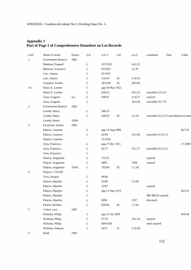
AFRODESC- Cuaderno de trabajo No.5; Working Paper No. 5-
112
Appendix 1 Part of Page 1 of Comprehensive Datasheet on Lot Records Lot# Name of owner Source L/G L/G # LoL w.e.f. comments Date Value
1 Government Reserve 1892
Martinez, Pasqual L 337/1923 24.2.23
Martinez, Francisco L 65/1937 3.2.37
Carr, Alanza L 67/1937
Carr, Alanza L 134/55 20 3.19.55
Casimiro, Fermin L 1815/82 20 28.9.82
1A Henry E. Loredo L app 30 May 1922
Henry E. Loredo L 656/22 30.5.22 cancelled 12.5.23
Arzu, Gregorio wri L 546/27 11.8.27 expired
Arzu, Gregorio L 18.4.50 cancelled 19.7.79
2 Government Reserve 1892
Loredo, Henry L 366/23
Loredo, Henry L 430/33 20 1.4.34 cancelled 10.11.37 cancellation revoked
Loredo, Henry 1950s
3 Escartinas, Santos 1892
Palacio, Catarino L app 14 Aug 1899 $27.22
Palacio, Catarino L 62/00 15.5.00 cancelled 25.10.15
Palacio, Catarino 15/1916
Arzu, Francisco L app 27 Dec 1915 27.5000
Arzu, Francisco L 41/17 15.2.17 cancelled 29.12.25
Arzu, Francisco L
Palacio, Augustine L 725/27 expired
Palacio, Augustine L 0805 1938 expired
Palacio, Augustine 1950s L 192/60 20 1.1.59
4 Palacio ? 23/4/99
Viris, Serapio L 86/96
Palacio, Hipolito L 54/00 3.5.00
Palacio, Hipolito L 10/07 expired
Palacio, Hipolito L app 13 Sept 1915 $25.61
Palacio, Hipolito L MP 384/33 expired
Palacio, Hipolito L 0090 1937 deceased
Palacio, Reuben L 818/64 20 1.1.64
5 Colesa, Luis 1892
Nicholas, Philip L app 12 Jun 1909 $39.46
Nicholas, Philip L 57/10 28.6.10 expired
Nicholas, Philip L 600/1926 dead expired
Nicholas, Fabiana L 5074 15 11.8.48
6 blank 1892
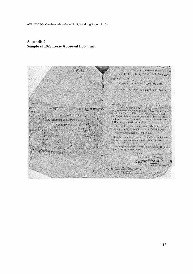
AFRODESC- Cuaderno de trabajo No.5; Working Paper No. 5-
113
Appendix 2 Sample of 1929 Lease Approval Document
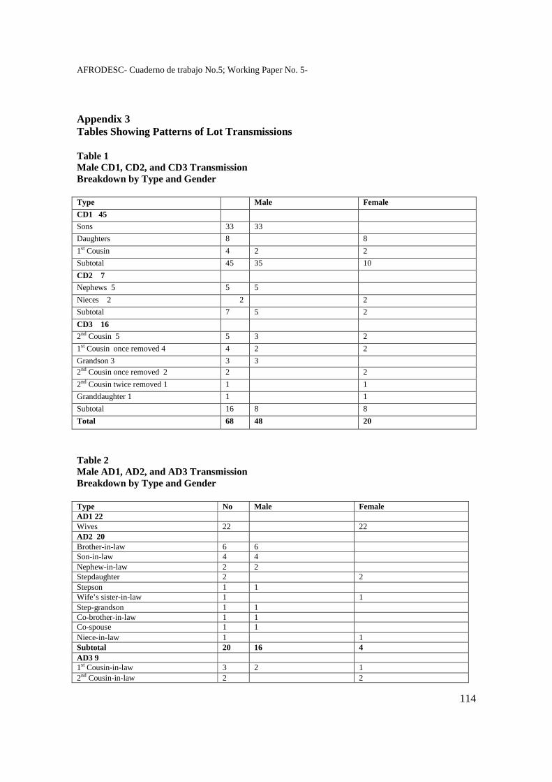
AFRODESC- Cuaderno de trabajo No.5; Working Paper No. 5-
114
Appendix 3 Tables Showing Patterns of Lot Transmissions Table 1 Male CD1, CD2, and CD3 Transmission Breakdown by Type and Gender Type Male Female
CD1 45
Sons 33 33
Daughters 8 8
1st Cousin 4 2 2
Subtotal 45 35 10
CD2 7
Nephews 5 5 5
Nieces 2 2 2
Subtotal 7 5 2
CD3 16
2nd Cousin 5 5 3 2
1st Cousin once removed 4 4 2 2
Grandson 3 3 3 2nd Cousin once removed 2 2 2
2nd Cousin twice removed 1 1 1
Granddaughter 1 1 1
Subtotal 16 8 8
Total 68 48 20
Table 2 Male AD1, AD2, and AD3 Transmission Breakdown by Type and Gender Type No Male Female AD1 22 Wives 22 22 AD2 20 Brother-in-law 6 6 Son-in-law 4 4 Nephew-in-law 2 2 Stepdaughter 2 2 Stepson 1 1 Wife’s sister-in-law 1 1 Step-grandson 1 1 Co-brother-in-law 1 1 Co-spouse 1 1 Niece-in-law 1 1 Subtotal 20 16 4 AD3 9 1st Cousin-in-law 3 2 1 2nd Cousin-in-law 2 2
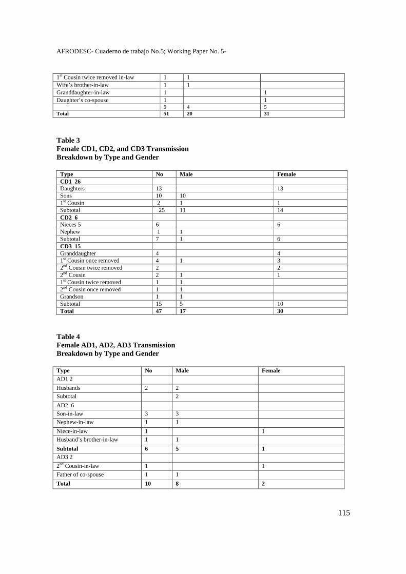
AFRODESC- Cuaderno de trabajo No.5; Working Paper No. 5-
115
1st Cousin twice removed in-law 1 1 Wife’s brother-in-law 1 1 Granddaughter-in-law 1 1 Daughter’s co-spouse 1 1 9 4 5 Total 51 20 31
Table 3 Female CD1, CD2, and CD3 Transmission Breakdown by Type and Gender
Type No Male Female CD1 26 Daughters 13 13 Sons 10 10 1st Cousin 2 1 1 Subtotal 25 11 14 CD2 6 Nieces 5 6 6 Nephew 1 1 Subtotal 7 1 6 CD3 15 Granddaughter 4 4 1st Cousin once removed 4 1 3 2nd Cousin twice removed 2 2 2nd Cousin 2 1 1 1st Cousin twice removed 1 1 2nd Cousin once removed 1 1 Grandson 1 1 Subtotal 15 5 10 Total 47 17 30
Table 4 Female AD1, AD2, AD3 Transmission Breakdown by Type and Gender Type No Male Female AD1 2
Husbands 2 2
Subtotal 2
AD2 6
Son-in-law 3 3
Nephew-in-law 1 1
Niece-in-law 1 1
Husband’s brother-in-law 1 1
Subtotal 6 5 1 AD3 2
2nd Cousin-in-law 1 1
Father of co-spouse 1 1
Total 10 8 2
AFRODESC- Cuaderno de trabajo No.5; Working Paper No. 5-
116
The Role of Ethnicity in the Internationalization of Belize’s Independence Struggle
ASSAD SHOMAN Investigador independiente
[email protected] Belice
Summary The independence of Belize was delayed for almost two decades because of a military threat from a neighbouring country (Guatemala) that claimed its territory. This paper explains how and why it was possible, in the context of the Cold War, for Belize to resist the pressures of the colonial power (the UK) and the US to compromise sovereignty and cede land in return for security. Belize’s efforts to achieve early and secure independence involved two related processes: negotiation and internationalisation. Belize was able to overcome disadvantages of size and power by taking advantage of the particular nature of the international context. The importance of the shifting conjuncture is evaluated, including the fact that the “Third World” and the United Nations were at the apex of their influence in the 1970s. The paper explores how the ethnic composition of Belize’s population impacted on the political significance of the Guatemalan claim in Belize and in Guatemala, and examines its importance for the strategy of internationalisation which succeeded in achieving the goals set by Belize. Keywords: Belize, Independence, Territorial Claim, Cold War, Ethnicity
AFRODESC- Cuaderno de trabajo No.5; Working Paper No. 5-
117
The role of Ethnicity in Belize’s Independence Struggles Introduction The struggle of the Belizean people for independence from Britain occurred in two distinct phases. The first, from 1950 to 1960, was a struggle against the colonial power; the second, from 1961 to 1981, was one to achieve full sovereignty with territorial integrity in the face of the territorial claim of neighboring Guatemala. In both phases, questions of “race” and ethnicity played a part in the development of the struggle. British people first began to settle in Belize in the 17th century, but it was not until 1862 that it was officially declared the colony of “British Honduras”, with a lieutenant governor answering to the governor of Jamaica. Earlier, in 1854, the first modern constitution had been enacted, with a Legislative Assembly elected on a very narrow franchise, and in 1872 Crown Colony rule from London through a resident Governor was instituted. The long delay between possession and assumption of sovereignty stemmed from the fact that the British government recognized the sovereignty of Spain over the territory. In the late eighteenth century Spain had accorded the British the right to cut and export wood in the area between the Hondo and Sibun rivers, but forbade them other activities; a Spanish commissioner would occasionally visit to ensure compliance with the treaties. Since the early eighteenth century, the Spanish had attacked the settlement several times, sometimes succeeding in removing the British for a time, but the last such attack, in which they were repulsed, occurred in 1798. By the time the Central American republics declared independence from Spain, the British had expanded their hold on territory as far south as the Sarstoon, and resisted the claims of Guatemala, which held that it had inherited the territory from Spain. Britain effectively challenged Spanish hegemony of the Central American coast, not only in Belize but also on the Mosquito Shore, which straddled the Caribbean coasts of Honduras and Nicaragua. In the 1840s, however, the US began to set its sights on the region. In 1823, the US had proclaimed the Monroe Doctrine, warning Europe off any new or re-colonization in the Americas – a position that challenged the British, who “proceeded to adopt and carry out a policy calculated to render ineffective the Monroe doctrine in so far as it conflicted with British designs”.1
US interest in Central America was heightened after the war with Mexico (1845-1848) resulted in the US taking California, among other territories, thus becoming a coast-to-coast nation in need of a maritime link between its two coasts. The long-standing idea of building an inter-oceanic canal across Central America had in the 1840s focused on Nicaragua. After gold was discovered in California it appeared especially urgent that the US secure this route.2 The new Central American states were weak and fighting among themselves; they suffered too from the incursions of U.S. filibusters. Britain and the US appeared to come close to open conflict, but they decided to resolve their differences
1 Mary Wilhelmine Williams, Anglo-American Isthmian Diplomacy, 1815-1915, Gloucester, 1965, p. 27. 2 R. A. Humphreys, The Diplomatic History of British Honduras, 1638-1901, London, p. 52; Williams, p. 58.
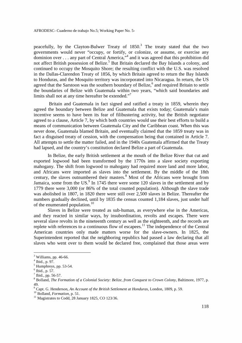
AFRODESC- Cuaderno de trabajo No.5; Working Paper No. 5-
118
peacefully, by the Clayton-Bulwer Treaty of 1850.3 The treaty stated that the two governments would never “occupy, or fortify, or colonize, or assume, or exercise any dominion over . . . any part of Central America,”4 and it was agreed that this prohibition did not affect British possession of Belize.5 But Britain declared the Bay Islands a colony, and continued to occupy the Mosquito Shore; the resulting conflict with the U.S. was resolved in the Dallas-Clarendon Treaty of 1856, by which Britain agreed to return the Bay Islands to Honduras, and the Mosquito territory was incorporated into Nicaragua. In return, the US agreed that the Sarstoon was the southern boundary of Belize,6 and required Britain to settle the boundaries of Belize with Guatemala within two years, “which said boundaries and limits shall not at any time hereafter be extended.”7
Britain and Guatemala in fact signed and ratified a treaty in 1859, wherein they agreed the boundary between Belize and Guatemala that exists today; Guatemala’s main incentive seems to have been its fear of filibustering activity, but the British negotiator agreed to a clause, Article 7, by which both countries would use their best efforts to build a means of communication between Guatemala City and the Caribbean coast. When this was never done, Guatemala blamed Britain, and eventually claimed that the 1859 treaty was in fact a disguised treaty of cession, with the compensation being that contained in Article 7. All attempts to settle the matter failed, and in the 1940s Guatemala affirmed that the Treaty had lapsed, and the country’s constitution declared Belize a part of Guatemala.
In Belize, the early British settlement at the mouth of the Belize River that cut and exported logwood had been transformed by the 1770s into a slave society exporting mahogany. The shift from logwood to mahogany had required more land and more labor, and Africans were imported as slaves into the settlement. By the middle of the 18th century, the slaves outnumbered their masters.8 Most of the Africans were brought from Jamaica, some from the US.9 In 1745 there were some 120 slaves in the settlement and by 1779 there were 3,000 (or 86% of the total counted population). Although the slave trade was abolished in 1807, in 1820 there were still over 2,500 slaves in Belize. Thereafter the numbers gradually declined, until by 1835 the census counted 1,184 slaves, just under half of the enumerated population.10
Slaves in Belize were treated as sub-human, as everywhere else in the Americas, and they reacted in similar ways, by insubordination, revolts and escapes. There were several slave revolts in the nineteenth century as well as the eighteenth, and the records are replete with references to a continuous flow of escapees.11 The independence of the Central American countries only made matters worse for the slave-owners. In 1825, the Superintendent reported that the neighboring republics had passed a law declaring that all slaves who went over to them would be declared free, complained that those areas were
3 Williams, pp. 46-66. 4 Ibid., p. 97. 5 Humphreys, pp. 53-54. 6 Ibid., p. 57. 7 Ibid., pp. 56-57. 8 Bolland, The Formation of a Colonial Society: Belize, from Conquest to Crown Colony, Baltimore, 1977, p. 49. 9 Capt. G. Henderson, An Account of the British Settlement at Honduras, London, 1809, p. 59. 10 Bolland, Formation, p. 51. 11 Magistrates to Codd, 28 January 1825, CO 123/36.
AFRODESC- Cuaderno de trabajo No.5; Working Paper No. 5-
119
“vastly inhabited by descendants of former Runaways”, and declared that if the matter were not resolved “this Settlement must be entirely ruined.”12
Unlike the other British possessions in the Caribbean where big sugar plantations were the order of the day and where large numbers of slaves lived and worked together, the mode of production in Belize was based on forestry, in which activity small gangs of workers went into the bush to find, cut and carry out the wood. This produced a different set of social relations than that prevailing in plantation societies, but there is no doubt that the master-slave relationship was essentially the same, with the slaves being treated as property, denied any autonomy and made subject to the whims and the cruelty of their masters.13 The British slave society in Belize went to great lengths to claim that slavery in Belize existed only in name, and that slavery there was humane and compassionate, to the extent that the slaves loved and were willing to die for their masters.
This was taken to its apogee by the society’s rulers when they constructed the “origin myth” of the territory. The incident in 1798 when the Spanish forces were repulsed for the last time was interpreted as the episode that confirmed the legitimacy of British possession of the territory. This myth-making had to do with the need felt by white settlers to have their power over the African slaves and their descendants recognized as legitimate. The first attempt to give this special meaning to the incident occurred 25 years after the event, in the wake of a major slave revolt and in response to accusations of cruelty to the slaves made by a former British superintendent of the settlement. They sent a document to Parliament stating that during the battle “there appeared a sacred tie between the Slave and the Master, which bound the one to the other” and that the behavior of the slaves demonstrated “the marked preference of these faithful Slaves to their state of bondage than to the freedom offered by the Spaniards”. Little use was made of the incident after emancipation, however, until an incident in 1894 demonstrated that the masses of black people felt as alienated from the colonial system as they did during slavery; by that time the Creole middle class was more firmly entrenched and collaborating closely with the colonial authorities.
Half a century after the abolition of slavery the masses of black people were no better of, and their labor conditions were akin to slavery. In 1894, following an effective devaluation which worsened their plight, workers led by John Alexander Tom organized a petition which set out their economic grievances but which also claimed that they were “the real inhabitants of the Colony, the men by the sweat of whose brow in the forests all its prosperity has been achieved.”14 When the modest demands of the workers were rejected, they rioted and looted the stores of major merchant houses. It was recognized that apart from economic grievances, the racism prevalent in the society was a major underlying cause of the riot. The Governor himself remarked on the fact that “the distinction between employers and employees . . . embraces the distinction of colour”. Nor was this an isolated incident; working class blacks were showing in many ways their dissatisfaction with the
12 Codd to Bathurst, 6 February 1825, Letters and Despatches Outwards R.4, BA. 13 See Bolland, Formation, for a full account of slave society in Belize. 14 “Petition of the Labourers”, set out in Assad Shoman, Thirteen Chapters of a History of Belize, Belize City, 1994, pp. 159-160. Emphasis added. The reference to the “real inhabitants may be seen as an attempt to establish the primacy of the working class to claims on the nation, as against both the British and the Creole aristocracy?
AFRODESC- Cuaderno de trabajo No.5; Working Paper No. 5-
120
prevailing system. Something needed to be done to establish the moral authority of the system and to give the black working class an enemy other than the white and high brown ruling class. In 1897 a group of middle class Creole began to agitate for celebration of the 100th anniversary of the battle of 1798; they “perceived a need to recognize and celebrate their own heritage as natives, and began to recast the history and legacy of the battle toward this end . . . the symbols of their heritage required validation by the crown and the colonial authorities, still masters of creole political, social, and, increasingly, ethnic identity”.15 The yearly celebration of the battle began in 1898, and it had a significant effect in shaping ethnic borders, although its main objective was to gain acceptance by the working class of their subordinate status; the white Creole editor of the Clarion condemned the rioters of 1894:
What a lesson in loyalty and confidence it would constantly be to those very people if their minds were turned back vividly to that September day at St. George’s Caye when the sturdy Baymen masters and slaves willingly stood forth shoulder to shoulder to shed their blood to defend the government and protect those they served.
It was very important for the Creole elite that working class blacks accept the origin myth, since a major part of its function was to have them adopt the ideal of workers loving their masters and “protect those they served”. They succeeded to some extent, aided by the Christianizing socialization process, as well as by ethnic identification and the hostility engendered in relation to the “Spanish”, which was by extension applied to the significant numbers of Mestizo people in the country. But working class “Creoles” continued to express significant challenges, more in actions than words, to this Creole elite vision of a just and harmonious society. In 1948, for example, a black worker denounced that “by perpetuating this little incident in our history, we are fostering and keeping alive enmity between the negro and Spanish elements in our community and are actually celebrating an English victory over ourselves. Today the negroes (the descendants of the slaves) are in nearly the same position as they were 150 years ago.”16
Slavery in the Americas and racism are inextricably linked. As Oliver Cox, writing about slavery in the United States, noted, the need for cheap labor was supplied by colonialism and the slave trade, and the cultural and physical differences between Africans and the white workers was used to keep the working class divided along ethnic lines.17 In Belize, however, the distinctions arise not only as between Africans and Europeans, but also involve other ethnic groups that were there, came or were brought.
The Ethnic Groups of Belize
Orlando Patterson defines ethnicity as “that condition wherein certain members of a society, in a given social context, choose to emphasize as their most meaningful basis of
15 Karen Judd, “Elite Reproduction and Ethnic Identity in Belize”, unpublished doctoral thesis. 16 Cited in Shoman, 13 Chapters, p. 139. 17 O. Cox, Caste, Class and Race, New York, Monthly Review, 1948.
AFRODESC- Cuaderno de trabajo No.5; Working Paper No. 5-
121
primary, extra-family identity certain assumed cultural, national, or somatic traits.”18 As Joseph Palacio has pointed out, Barth19 “has best explained the concept that ethnic groups become identifiable only when they are in opposition to others that are close by and with whom they interact.” Palacio goes on to note that “ethnicity appears not as an independent variable that can stand on its own; rather it is an ingredient in group identification within the larger framework where the political economy interfaces with the social structure. As such ethnicity assumes importance as a configuration of cultural characteristics that may gain currency at some times and lose at others.”20 And Bolland adds the important dimension relating to colonial societies, where different groups are recruited to join it depending on the economic needs of the colonizers:
It is because of this legacy of the colonial conditions that the analysis of race, ethnicity and nationalism cannot afford to neglect issues of class and power. The ways in which people identify themselves or classify each other in terms of race or ethnicity are profoundly affected by their positions and relations in the economy and power structure of their society. This is especially evident in colonial societies in which a variety of racially and ethnically distinguished groups have distinct economic functions and are bound together only by the political hegemony of the colonial power.21
Carla Barnett warns further that “the definitional problems stem not only from difficulties with operationalizing the concepts of race, ethnic group and cultural group in any context, but also from the reality in Belize of a multiplicity of diverse groups moving, mixing and otherwise bedeviling any attempt at abstract classification.22
In this paper I will concentrate on those ethnic groups in Belize, excepting the British settlers, that were established by the middle of the 19th century: the indigenous Maya, the “Creole”, the Garinagu and the Mestizo.
The indigenous Maya in Belize had put up fierce resistance to the Spanish invaders, who encountered them early in the sixteenth century, and for the rest of the century there were many battles between them. Grant Jones estimates that before the Spaniards arrived Belize was home to some 200,000 Maya; by mid century diseases and war had reduced their numbers to around 50,000.23 The Maya resistance continued throughout the seventeenth century, until in 1696 the Spaniards defeated the Itzas, and a decade later transported the Maya from Tipu, their last stronghold in western Belize, to Lake Peten Itza. As early as 1701, British pirates were capturing Maya peoples to sell elsewhere as slaves. The British logwood cutters hardly encountered the Maya, who had retreated from coastal areas after their clashes with the Spanish, but when mahogany became the principal export and the cutters had to venture inland, they began to experience Maya resistance to their
18 Orlando Patterson, “Context and choice in ethnic allegiance; a theoretical framework and Caribbean case study”, in Ethnicity: Theory and Experience, ed. By Nathan Glazer and Daniel P. Moynihan, Cambridge, 1975. 19 F. Barth, Ethnic Groups and Boundaries, Boston, 1969. 20 Joseph Palacio, “May the New Belize Creole Please Rise”, paper presented at the National Cross-Cultural Awareness Conference, 26-27 March 1988, SPEAR, Belize City, 1988. 21 O. Nigel Bolland, “Race, Ethnicity and National Integration in Belize”, in Belize: Ethnicity and Development, SPEAR, Belize City, 1987. 22 Carla Barnett, “The Political Economy of Land in Belize”, unpublished Ph. D. Thesis, University of the West Indies, Mona, 1991, p. 149. 23 Grant Jones, Maya Resistance to Spanish Rule, Albuquerque, 1989.
AFRODESC- Cuaderno de trabajo No.5; Working Paper No. 5-
122
incursions: a report of 1809 speaks of “numerous tribes of hostile Indians [who] often left their recesses in the woods for the purpose of plunder”; they were said to “wander over an immense extent of country but little known.”24 Another report thirty years later makes reference in similar terms to Maya attacks on the British in the western district of Belize.25 In 1847 the Maya began a protracted war against the Spanish and their successors in Yucatan, known as the Guerra de Castas, and the war soon spilled over into Belize, having a huge effect not only because of the large numbers of refugees who changed the demographics of the country, but also because the Maya armed resistance extended into Belize and affected the constitutional development of the colony, and was responsible for the imposition of Crown Colony rule in 1871. In succeeding years, the Maya in the north progressively became acculturated to Mestizo culture, whereas those in the south, augmented by immigration from Guatemala, succeeded to a large extent in maintaining their culture and their physical spaces. The British established land reservations for their use, but denied them the right of autonomy and the lands remained under the authority of the colonial government.
The “Creoles” in Belize are understood to be those of mixed African and European descent, although they include people of African descent with other mixtures, but excluding the Garinagu. The critical element, in terms of “racial” categories, is the African. Creole society refers to the culture created fundamentally out of European and African elements, but including other cultural influences. During the time of slavery, certain slaves managed to gain their freedom legally and continued to live and work in the society; they were known as “free colored”, and were often children of slave women with their white masters. Some of them became slave owners, and eventually won certain rights which they campaigned for on the basis of their greater assimilation to the whites than the “free blacks”.
British colonialism imposed slavery and the capitalist system, with the legal, military, political, social and religious institutions to sustain them, and endeavored to dictate the nature of the society. But the thoughts, expressions and everyday actions of African people and their descendants, who outnumbered the whites overwhelmingly, had an important influence on the cultural formation process. They were the living carriers of a transforming culture, one that would envelop, to some degree, all groups and classes in the society. Belize Town, where the overwhelming majority was of African descent, was the centre of the process of “Creole” cultural formation.
The Creole society that emerged from this process was one in which the lighter skinned Creoles had an advantage, with greater opportunities for advancement through social networks and education. The small Creole peasantry could barely eke out a living from the soil, and it was not easy for the Creole laborer to escape from the mahogany camps, but some did, and by the end of the nineteenth century several Creoles occupied positions as clerks in commercial establishments or on the lower rungs of the civil service. According to Cedric Grant, writing in the 1970s,
24 G. Henderson, An Account of the British Settlement of Honduras, London, 1809. 25 David Pendergast (ed.), Palenque: The Walker-Caddy Expedition to the Ancient Maya City, 1839-1840, University of Oklahoma Press, 1967.
AFRODESC- Cuaderno de trabajo No.5; Working Paper No. 5-
123
The Creole culture also has a distinctive occupational pattern. The high and middle economic status groups opt for the elite positions in law, teaching and the civil service . . . The lower income group has traditionally pursued forestry operations as their main occupation. Since the decline of this industry they have found casual or intermittent employment as domestics, street vendors, unskilled labourers in the construction industry, longshoremen, fishermen and self-employed petty artisans.26
He adds that in the heyday of colonialism “the middle class whose members are brown and black in colour . . . reacted to its precarious relationship with the upper class by frequent displays of antipathy and a discriminatory attitude towards members of the lower class.”27 The upper class was generally white, the lower generally black. In terms of the civil service, Grant notes that up to the middle of the twentieth century,
Governors were highly selective in their choice of local administrative personnel. Priority went to those civil servants who were from the high-status Creole families with a long tradition of public service. And since within the Creole community there was a correlation between colour and class, a high proportion of the local senior civil servants were of unmistakeable European descent or of light complexion. As members of the Creole elite they had traditionally lent support to the status quo and if they were not always rewarded with full admission to the inner circles of expatriates they at least won their social approval. Together the two groups gave leadership to the society. They set its social tone and values, worshipped in the leading Protestant churches, participated in inter-club activities, and held common membership to other prestigious organizations . . .28
The people thus described were members of the Creole elite, or what Belizeans sometimes call “royal Creole” or Creole aristocracy. Generally speaking, they sought to suppress their African ancestry and highlight their British connection,29 whether through heredity or mimicry, and resisted the nationalist movement when it became clear that the intention was to include all the people, from all classes and ethnic groups and districts, in the governance project. The masses of the Creole people, on the other hand, were those in the forefront of the anti-colonial struggle, those who had no reason to love things British and were determined to fight for a new order of things, for freedom and independence. They were the principal bearers of the Creole culture and in particular the language, which the royal Creoles disdained and punished their children for using. The Belizean Creole language is English-based, but its phonology, vocabulary and syntax differ significantly from standard English, and is influenced by African and Spanish languages, and increasingly by the English spoken in the U.S. (That language has since become an important adhesive that bonds the entire nation, given that whatever a person’s primary language may be, Kriol—as it is now spelt by those who promote the language and have compiled a dictionary and other aids to its use—is the language most widely spoken by all ethnic groups and peoples in all regions of the country.)
26 Grant, p. 15. 27 Ibid. 28 Ibid., p. 98. 29 Grant states that “the African element of the culture when not devalued has been subordinated to the British. This was largely the result of the socializing influence of the Protestant churches—Anglican, Scottish Presbyterian and Methodist—whose membership was predominantly Creole. As standard-bearers of British values and codes of behaviour these denominations channelled their efforts mainly through the educational system which they had shaped and controlled during the Crown colony period”. Grant, p. 14.
AFRODESC- Cuaderno de trabajo No.5; Working Paper No. 5-
124
The Garinagu, a people born of the mixture of Africans and indigenous people of the Caribbean, first came to Belize at the beginning of the nineteenth century, and established a strong presence in southern Belize. By 1835 they were said to be “carrying on a constant traffic by sea with Belize [Town]” in crops and poultry, and many of the men worked in the forestry industry.30 Despite their proven agricultural proficiency, the Garinagu were not allowed to get good title to lands by occupation as did the British settlers. In 1872, the colonial government created land “reserves” for “the Indians or Charibs” (the former referred to the Maya, the latter to the Garinagu), but all they got were permits to occupy portions of lands they had been working and living on, renewable yearly, and the government could cancel such permits for cause. The so-called Carib Reserves seemed to have been disbanded in the 1930s. The Garinagu, despite their small numbers and concentration in the south, progressively became more involved in the economic, social and political life of the nation, although they succeeded to a remarkable extent in maintaining important aspects of their culture, including language, food habits, religion, music and dance. For most of their period in Belize they have been discriminated against by Creoles, who, encouraged by the British, developed negative stereotypes toward them. The element in their history which most distinguishes them from the other African-descended peoples of Belize is that they as a people were never enslaved, and had a Caribbean-wide reputation as fearless warriors.
Refugees from the Caste War of Yucatan in the middle of the nineteenth century doubled the population of the country, and settled in the north of Belize, prompting the first attempts at industrial agriculture with the production of sugar cane. Most of the refugees were Mestizos (a mixture of Spanish and the indigenous Maya) and Maya people, and they radically changed the ethnic composition of the country. Although they were instrumental in establishing the sugar industry in the north, increasing agricultural production generally and generating trade with Mexico, they were for the most part marginalized from the political life of the colony until the middle of the twentieth century. The waves of migration from Mexico resulted in converting the Creole population into a minority by 1861, when the census recorded 37% of the respondents as Spanish-speaking Spaniards and Mestizos, while 18% were Maya.31 The Spanish-speaking people became economically and socially predominant in the northern districts, but played no significant part in the political processes of the colony, which was dominated by English-speaking whites and Creoles. Deprived of a role in government and the civil service, they excelled as businessmen, and also eventually penetrated that sector in Belize City. As Grant postulates, “the Creole elite acted and behaved as if Belize City was Belize with the result that the predominantly Latin peasantry was in the colonial society but not of it.”
Having described these ethnic groups in a differentiated way, it must now be emphasized that in Belize the divisions are never as clear-cut as such a description would suggest. Grant insists that “Belize is not simply a collection of diverse cultural elements grouped into two main cultural complexes [the “Latin” and the “Creole”]. The differences not only in race but also in culture, language, religion and occupation cut across each other to produce an extremely complex pattern of social and political life.”32 Joseph Palacio puts
30 Shoman, 13 Chapters, pp. 80-81. 31 Lindsay, Bristowe and Wright, The Handbook of British Honduras for 1888-1889, London, 1889. 32 Grant, p. 20.
AFRODESC- Cuaderno de trabajo No.5; Working Paper No. 5-
125
it thus: “The creolization process has never stopped; rather the blending has become richer as the number of the ingredients multiplies. Currently there is taking place the formation of the new Belize Creole socio-culture to which all the ethnic groups are contributing.”33
The Nationalist Movement and the Ethnic Factor
The groundings for the independence movement were laid by the workers’ movements of the twentieth century. A riot in 1919 was started by over 300 men returned from serving the British in the Great War, who had suffered racist treatment in the service and who continued to be exploited on their return, but they were soon joined by over 3,000 residents of Belize Town, who became more active and violent than the ex-servicemen. Although much of the resentment that sparked the riot had to do with the economic conditions suffered by the people, the racist treatment to which they were continuously subjected was undoubtedly an important element. A policeman reported that he often heard the phrase “white son of a ____” uttered by the rioters. The situation was brought under control when a British warship landed 100 marines, and the Governor later proclaimed martial law. The Governor reported that during the incident the people had shown an “open inclination to be insulting to Europeans in the street.” People were heard to make such statements as “these are the brutes we do not want here,” referring to white men; “this is our country and we want to get the white man out”; and “we are going to kill the white sons of bitches tonight . . . This is a black man’s night.”34
This is our country.
This is the first instance I have found of black people in Belize, the descendants of Africans brought as slaves, articulating the demand to recognize this land as theirs, to proclaim a right to this country. They did so as against their former masters, against the white man; they did not in any way reference the indigenous Maya or other ethnic groups in the colony.
Black consciousness had undoubtedly been developed with the coming of the Garveyite movement to the colony earlier in the century. Indeed, it was found that the Governor’s ban of the periodical Negro World, the official organ of Garvey’s United Negro Improvement Association (UNIA), was one of the grievances that fed the riot. A local newspaper, the Belize Independent, also carried a column called “The Garvey Eye,” and in 1920 a local branch of the UNIA was formed, with prominent middle-class blacks in its executive. Garvey himself visited Belize in 1921, but he was not very critical of the colonial regime; and by 1926 the movement was rendered harmless by factionalism in the parent U.S. body, and the social arm of the movement, the Black Cross Nurses, was soon co-opted by the colonial establishment. Still, the movement enhanced the sense of black consciousness which contributed significantly to the later rise of the nationalist movement.
So too did the workers’ movement of the 1930s led by Antonio Soberanis and others. In the face of the severe depression affecting the economy, exacerbated by the destructive hurricane of 1931, the workers demanded a living wage and also referred to the
33 Joseph Palacio, “May the New Belize Creole Please Rise”, paper presented at the National Cross-Cultural Awareness Conference, 26-27 March 1988, SPEAR, Belize City, 1988. 34 Grant, pp. 162-164.
AFRODESC- Cuaderno de trabajo No.5; Working Paper No. 5-
126
competition of immigrant workers from Central America, calling for all work places to ensure that 90% of their workers be British subjects. The petition to the Governor organized by Soberanis which made those demands also declared that “we are a new People”, spoke of the country as “our own Native Land”, and further intoned:
We want to be friends with the White Men, because neither the black, yellow, brown or white race can achieve anything in the World lastingly, except through peaceful methods . . . Your Excellency knows that no race has the last word on culture; and on civilization, your Excellency do not know what the People of British Honduras is capable of doing.35
Apart from the references to “race” and the resentment at job competition from immigrants (the majority of whom happened to be mestizos from neighboring countries), what is significant here is the straightforward claim that “we are a new people, and this is our native land,” an assertion that was undoubtedly made as against the British, and that would find an echo in the rhetoric of the later independence movement.
It was also the workers’ movement that first sought to be inclusive of the regions beyond the capital and their diverse peoples. In 1934, Soberanis spread his campaign to other towns, and led a successful strike of stevedores in Stann Creek Town (Dangriga). His movement also helped to bring about constitutional change in 1936, although its demands for universal adult suffrage were not met. At that time, and until 1943, trade union activity was illegal in the colony. Thereafter, the General Workers Union (GWU) was formed; beginning with a membership of some 350, it grew to three thousand before the end of the decade, and carried out successful union activities in all districts of the country and among all ethnic groups.
The PUP, Federation and Guatemala
The independence movement took political form in 1950 with the founding of the People’s United Party (PUP), which proclaimed the aim of achieving political and economic independence. All the first major leaders of the Party were “Creoles” from Belize City, but they recognized the urgent need to reach out to other peoples in the districts and create a sense of national unity. This is where the network of GWU branches became essential to the nationalist project, and indeed in the first national elections with universal adult suffrage in 1954 it was the union that provided candidates in most of the divisions outside of Belize district. In 1952 the colonial authorities had supported the formation of another party, the National Party (NP), whose leaders were also all “Creoles” from Belize City, including people associated with the Garveyite movement and with the earlier workers movement. The PUP won eight of the nine seats and 65% of the votes; the NP one seat (Toledo) and 22.5% of the votes. The lack of PUP support in Toledo reflected the weakness of the GWU in that district, which was predominantly rural.
Although the PUP based its campaign squarely on the issue of colonialism and the economic conditions affecting the people, a major issue imposed by the colonial state was the external orientation of the country, and this is the issue that became the most divisive throughout the period culminating in Belize’s independence. The issue was whether Belize should become part of a “West Indies Federation” that would encompass the British
35 Ibid., pp.169-170.
AFRODESC- Cuaderno de trabajo No.5; Working Paper No. 5-
127
colonies in the Caribbean or whether it should pursue a Central American destiny, given its geographical location on the isthmus.
As part of its general decolonization policy, Britain had developed the idea that a federal structure could create more viable post-colonial states, since self-government seemed unrealistic for small populations. Nicholas White opines that “the federations all illustrate an imperial desire to refashion empire and, in so doing, strengthen, rather than weaken, ‘the British connection’ with overseas dependencies.”36 This is certainly how it was seen by the Belizean leaders of the independence movement, who also feared the effect of a “West Indian invasion” on the job market. They effectively exploited parochial sentiments and used the British West Indies Federation as a major weapon in their attacks against colonialism. Indeed, Leigh Richardson, who became the leader of the Party in 1952, wrote that if Belize were to have an association with any region, it should logically be with Central America.
The question of the posture assumed by the PUP with regard to the Guatemalan claim was made a major issue by the British colonial government. From the time of its formation, the PUP leaders took the position that the claim was one for Britain to resolve, and that there should be friendly relations between Belize and its neighbors. Indeed, after a visit to Guatemala in 1951 as a guest of the Newspaper Association there, Goldson wrote an article called “Seven Days of Freedom” in which “he described conditions in that country in a way that was calculated to earn the envy of Belizeans.”37 And a colonial government inquiry into “contacts” between PUP leaders and Guatemalan authorities found that Richardson, Goldson and Price did have such contacts, although it did not in any way substantiate the implicit charge that they were acting contrary to the interests of Belize and in favor of Guatemala’s claim. This colonial charge, also articulated by the NP, had little effect on the outcome of the 1954 elections, but after the split in 1956 (see below), the colonial government took the opportunity to intensify its campaign to discredit Price on the ground of his assumed sympathy for Guatemala. In the incident of 1957 where the British dismissed Price from the Executive Council because he and three others of a Belizean delegation in London had sustained talks with a Guatemalan representative there, the Governor, in a radio address, declared that Price “was prepared in certain circumstances to see you, the people of this country, handed over to the Guatemalan Republic lock, stock and barrel.”38 After 1961, when the British had decided to disengage from Belize as quickly as possible, they sought to reach accommodations with Guatemala at the expense of Belizean sovereignty and territory, and had then to face Price’s total opposition to their schemes, but the charges they had laid against Price in the 1950s continued to be repeated by the local opposition right up to the moment of Belize’s assumption of independence.
What concerns us here is whether and to what extent the Guatemalan claim, and the charges levelled against the PUP and Price in particular of partiality with Guatemalan, had any resonance in Belize in terms of its ethnic composition, in the light of accusations that the PUP favoured links with Guatemala in order to “Latinize” the country. The fact is, however, that although some commentators have suggested otherwise, the Mestizo population of Belize during the nationalist period never supported Guatemala’s claim to the 36 Nicholas J. White, Decolonization: the British Experience since 1945, Longman, London, 1999, p. 20. 37 Grant, p. 156. The article appeared in the Belize Billboard, 24 September 1951. 38 Telegram to London, 2 December 1957, FO 371/126383.
AFRODESC- Cuaderno de trabajo No.5; Working Paper No. 5-
128
territory. Their knowledge of the conditions of people, and especially of indigenous people, in Guatemala and of the generally abysmal record of human rights by the governments of that country since 1954, and their own increasing nationalism stemming from their greater acceptance and participation in the affairs of the emerging nation, made them firm supporters of the nationalist thesis of the political parties. And as we shall see, the belated Guatemalan government attempt to woo the support of indigenous and Garifuna people to their cause was a miserable failure.
Because the geography of Belize has borne a culturally differentiated imprint from the nineteenth century, with the several ethnic groups spatially and occupationally separated, and because political activity was concentrated in the tiny enclave of Belize City, where the majority were “Creole”, there was, until 1954, great disparity in the representation of the various ethnic groups in the organs that exercised the very limited powers accorded to them by the colonial system. In the 1954 elections, the most significant development was “the correction of the imbalance in [the electorate’s] geographical and cultural distribution.”39 In the 1948 election, 70% of the voters were in the Belize District; in 1954 this fell to 53.4%. Belize District had four constituencies and the “outdistricts” five; the GWU fielded candidates in four of these (excepting Toledo), and they won by larger margins than their PUP colleagues in Belize City. This reflected the fact that the NP leaders continued to behave as if the only district that mattered was the Belize District; it also set a pattern that held for several elections, of the PUP being more dominant in rural areas than any other party. The fact that, apart from Belize District, all rural populations were non-”Creole”, however, does not necessarily mean that the PUP was directing greater attention to other ethnic groups, but simply reflected the historical development of the country in terms of ethnic distribution. The long-standing dominance of the PUP in rural areas bears several explanations. First of all, among the early PUP leaders it was Price that had the more urgent vision of the need to include all peoples in the territory in the nationalist project: for there to be a legitimate claim to establish Belize as an independent country in an age of democracy, then all its diverse peoples must be involved in the struggle. In the first two decades of the nationalist movement, no other politician worked every corner of the country as did Price, and this served his party well in successive elections. The pattern of land tenure in the colony was also of tremendous significance. The colonial forest economy had developed in such a way that from the late nineteenth century there was an extreme latifundia pattern of land ownership, and in 1960 6% of freeholders owned 97 % of privately owned land; one British company alone owned over a million acres, or one-fifth of the national territory.40 This meant that most rural dwellers were landless, and the PUP was able to distribute land to them and win their electoral support, whereas it was a much harder proposition to establish industries and provide jobs for urban people. Price’s projection of the Belizean peoples’ claim to the country and its future orientation must be understood in the context of the colonially imposed myth that the British had a right to the territory because they had found an empty land and civilized it. To this he counter-posed the fact that the territory had been occupied long before the British came by the Maya, who had developed a high civilization and who had never abandoned
39 Grant, p. 162. 40 Bolland and Shoman, Land In Belize 1765-1871, Kingston, 1977, p. 104.
AFRODESC- Cuaderno de trabajo No.5; Working Paper No. 5-
129
the territory; this made the British usurpers rather than legitimate owners. As Grant posits, rooting the identity of the country in the indigenous Maya “could be made to appeal as much to the nationalist-minded within the Creole complex as to the Mestizo element. For if it reminds the latter of its cultural affinity with the other Central American countries it also gives Belize autochthonous claim to power.”41 The PUP had to take into account the fact that a large part of Belize’s population was made up of immigrants from neighboring countries, many of whose ancestors had come to work in Belize as far back as during the days of slavery, and that they had to be included in the nationalist project. But the PUP’s early insistence on a Central American destiny for Belize was not based on ethnic considerations, but rather on the need to reject what it considered the British scheme of false decolonization, which would continue to tie the country to British interests through the West Indies Federation. After 1955, it became clear that Price’s rejection of British tutelage went deeper than that of Richardson and Goldson, who as members of the Executive Council with portfolio responsibilities began to feel a greater affinity with the colonial administration than their earlier anti-colonial sentiments would have merited, and Richardson even wrote in favor of Belize joining the West Indies Federation, “which he now saw as mutually beneficial to all colonial territories in the region.”42 Price’s continued opposition to cuddling up to the British made him persist in speaking of Belize’s Central American destiny, whereas Richardson had to find reasons for rejecting it, and he hinted at cultural differences as a factor. He argued that although the Central American countries “spoke the same language and were the same people with similar political background,” they could not establish a successful federation.43 As Grant points out, what he was inferring was that “if a fairly culturally homogeneous community of people could not remain united, then it was difficult to conceive of Belize with its different political tradition and a deviant but sizable group, the Creole, faring well among them.”44 (In the end, of course, the West Indies Federation itself was extremely short-lived, collapsing in 1961.) A few months later, in July 1956, Richardson took the further step of denouncing “race” prejudices within the Party, alleging that when the nationalist movement began in 1950 “there were certain persons who felt that the leaders ought to be the Latins among us and so they led until one thing or another swept Creole leaders into the forefront. Certain Latins have never forgotten that and have been scheming ever since to uproot the Creole leaders.”45 It is not clear what “Latin” leaders Richardson alleges led the PUP, nor which “one thing or another” swept Creole leaders into the forefront, nor who those supposedly new leaders were. The first leaders of the PUP were: John Smith, leader; Leigh Richardson, Chairman; George Price, Secretary; and Phillip Goldson, Assistant Secretary. All were embedded in what Grant calls “the Creole complex,” although two were lighter-skinned than the others. Later, Richardson became the leader, but he did not displace any “Latins” to do so. What may be the case is that Richardson was losing the argument for his new-found position of promoting federation with the “West Indies”, and that he sought refuge in
41 Grant, pp. 168-169. 42 Ibid., p. 172 43 Richardson’s report to the PUP membership meeting of 5 March, in the Belize Billboard, 7 March 1956. 44 Grant, p. 173. 45 The Belize Billboard, 29 July 1956.
AFRODESC- Cuaderno de trabajo No.5; Working Paper No. 5-
130
“race matters” to buttress his new position. Thus, in making his case against association with Central America, he argued that the Central Americans themselves were seeking to develop economic and cultural relations “with these same West Indians whom some people would have us despise.”46 The fact is that the most vocal opposition to such federation came from working class blacks in Belize City, who feared job competition from the islands, and who saw the federation as a British attempt to maintain its influence in the region. Richardson also used the Guatemalan claim as part of his argument, stating that the only Central American country that showed any interest in Belize was Guatemala, which was pressing its claim to Belizean territory.47 As far as the “Latins” are concerned, at that time, as Grant explains, they were underrepresented in national politics:
The Latin elite had not been encouraged to become actively involved in politics because they were considered by the colonial administration to be untutored in the norms and administration of central colonial government. This had a debilitating effect on this group and functioned as a sort of self-fulfilling prophesy for the colonial government and the Creole elite: the latter, as the Courtenay Commission stressed, was cognizant of the strategic function that it performed in the Crown colony period and continued to assert its eligibility for this role in the decolonizing process . . . Few of [the Latin elite] had penetrated the inner core of the PUP national leadership at the time of the PUP split.”48
The reference to the Courtenay Commission is instructive. The Commission had been appointed in 1948 to propose constitutional changes, before the nationalist movement erupted, but it did not report until 1951. Its chairman was the attorney general, a British official who fell ill and returned to Britain in December 1949; he was replaced by Harrison Courtenay, a distinguished lawyer and critic of the colonial government who had campaigned for constitutional reform. In the changed circumstances brought about by the PUP and its all-nation project, however, he and the other members of the Commission, all representatives of the “old Creole elite”49 felt the need to guard against what they considered a dangerous unfettered democracy, and their report constituted a barefaced attempt to maintain the power and privilege of the Creole elite. They argued that there must not be any “premature extension of political responsibility”, especially in a multi-ethnic country like Belize:
The advance in general and political education has not been uniform among all the races which comprise the Colony’s population, and the lack of balance arising from the long lead which the largest group [Creoles] enjoys over the minorities calls for the establishment of a system which, while meeting the legitimate aspirations of the one does no violence to the interests of the other.50
Their suggestion to restrict the democracy of “the minorities” was two-fold: firstly, after noting that 42% of the “Amerindians” and 22% of the “Caribs” were illiterate, and that English was the first language for less than half of the population in every district except Belize, they proposed a literacy test for voters, cynically adding that “the proportion of illiterates for the whole colony is in any case so small that little harm will be done by
46 The Belize Billboard, 7 March 1956. 47 Ibid. 48 Grant, pp. 175-176. 49 Grant’s term: Grant, p. 149. 50 Report of the Commission of Inquiry on Constitutional Reform 1951, Government Printer, Belize City, 1951.
AFRODESC- Cuaderno de trabajo No.5; Working Paper No. 5-
131
their exclusion”. Secondly, they proposed, for the districts outside Belize, a system of indirect voting by part-nominated town boards and village councils, on the assumption that those people were too backward to exercise the direct vote. The PUP campaigned vigorously against these discriminatory proposals, and in the end the British government conceded universal adult suffrage.
Had the proposals of the Creole aristocracy been implemented, it is likely that politics in Belize would have pursued a path of ethnic conflict, with political parties reflecting the interests of different ethnic groups. In the event, this did not happen, and none of the parties that have emerged in Belize thereafter have even courted the possibility of aligning themselves exclusively or predominantly with one ethnic group. The long-standing dominance of Belize City in national politics and the marginalization of the outdistricts would naturally have predisposed the emerging political system to develop along ethnic lines, but the nationalist ideology which imbued the major actors in the developing two-party system prevented this from occurring. Crucial to this development was the fact that Richardson and Goldson, who had formed the Honduran Independence Party when they left the PUP, merged with the National Party in 1958 to form the National Independence Party (NIP); Goldson eventually became the leader of the Party, and stamped it with the national flavor which he had promoted as a leader of the PUP. That is to say that neither of the two major political parties that predominated in the pre-independence period, the PUP and the NIP (later UDP), sought to win support from any one ethnic group as against any other. If it is true, as Grant states, that it was the PUP that first used the opportunity, in 1957, “to take account of the cultural factor in party politics” by ensuring that his party’s candidates for the Corozal, Orange Walk and Cayo districts were resident Mestizos and that in Stann Creek and Toledo they were Garinagu, whereas none of the candidates of the opposition parties was a Mestizo,51 nonetheless by the next following general elections in 1961, when the electoral divisions had been increased to 18, both major parties put forward candidates in all divisions, except Toledo, whose ethnicity reflected the majority ethnic group in the area. In Toledo North, the PUP candidate was Garifuna and the NIP Creole, whereas in Toledo South the PUP candidate was Creole and the UDP Garifuna. There have been exceptions, but the pattern was set and it has prevailed. In other words, both parties have ample representation of the major ethnic groups in the society. It is significant that neither of the two parties presented a Maya candidate in Toledo until 1974, when both did, and they both repeated this in 1979, the last general election before independence.52 It can be confidently asserted that by 1965 the prospect of Belizean politics becoming tainted with “racial politics” had been largely surmounted. The Guatemalan claim continued to provide some fodder to those few who may have been inclined to introduce the “race” question into politics, but it was always the case that the Mestizo population rejected the claim as much as did the Creoles, in like manner that it was the majority working class Creoles in the 1950s that were most vehemently opposed to the West Indies federation; in other words, their positions were not based on ethnicity but on nationalism and self-interest. Such was the situation when, in 1969, “like an erupted volcano spitting forth lava,”53 the “race” question became a major issue with the emergence of the United Black
51 Grant, p. 182. 52 Myrtle Palacio, Who and What in Belizean Elections, 1954 to 1993, Belize City, 1993. 53 G. S. Rene in the Belize Billboard, 8 June 1969.
AFRODESC- Cuaderno de trabajo No.5; Working Paper No. 5-
132
Association for Development (UBAD), which drew its inspiration from the Black Power movement in the U.S. Its leader was Evan X Hyde, a recently returned graduate from the U.S., who defined it as “strictly a cultural association aimed at making black people over the world realize that they have a history, culture, heritage and beauty of which they should be justly proud”.54 The organization took on the latent racism in the society and addressed, in a more profound and sustained manner than any other before or since, questions of racism and of ethnic relations in Belize. Despite its emphasis on “black” and its penchant for calling the country “Afro Honduras”, UBAD preached unity for all non-white peoples of Belize and claimed to favor them all, defining “black” as being in “four parts: the black, the brown, the red and the yellow.” It acknowledged the white man as the historical and current oppressor, and declared that “every white person until proven otherwise must be considered an enemy to freedom, justice and equality.”55 Hyde was especially critical of what he termed “the Creole bourgeoisie,” or people with black skins and white masks, and excoriated them for perpetuating the British-inspired origin myth:
No one can deny that the most effective historical source of division between the tribes in our society has been the so-called Battle of St. George’s Caye . . . The myth was created that white master and black slave fought hand in hand against a dastardly aggressive tyrant—the Spaniard . . . For the sycophantic Creole bourgeoisie class, the 10th represented a legitimization of their supremacy in the civil service administrative circles of government . . . For the English, the 10th has been an opportunity to divide the native society by allying themselves with the Creole bourgeoisie class against the “niggers” and the “Pania” and the “Kerobi”.56
He concludes that the Creole bourgeoisie saw the “Battle” as “the legal historical
foundation of their right to be an exploiting class”. The reaction against UBAD was virulent. PUP leaders (but Price kept out of the
fray) denounced it as communist and divisive, but it was the NIP, which figured it had the most to lose, that most consistently and aggressively attacked it along the lines of the article in its newspaper:
UBAD had wasted no time in spewing its venom of hate against the white man . . . This group preaches bitterness against the slave-master for having enslaved the black man. But that same slave-master gave the black man his freedom as far back as 1834 and the last vestige of hatred between them has long been buried in the dust of oblivion . . . the white man and the black man have long been sharing the world and its amenities in understanding brotherhood . . . Here in British Honduras we have lived as many races but one people. Peace and quiet have been the order of things. We work, worship, love and play together . . . The different races have never tried to project any kind of superiority one over the other. There is no control from any slave-master.57 On the question of animosity between the “Latin” and “Creole” elements in the
society, the UBAD position is stated in this 1969 article in the Amandala: Many of the so-called Creoles in the capital are bemoaning the Latinization of this and the Latinization of that but they should first question their own conscience. For many years the Creole bourgeoisie were the slavemaster’s pet and discriminated openly against the “yellow belly panya” and the “Kerobi”. When the Creole bourgeoisie realized that the young PUP movement was going to
54 Evan X Hyde in an interview in the Belize Billboard, 15 June, 1969. 55 Evan X Hyde, The Crowd Called UBAD: The Story of a People’s Movement, Belize City, 1970. 56 Evan X Hyde, Knocking Our Own Ting, Belize City, 1969. 57 “Beware of UBAD”, the Belize Billboard, 8 June 1969.
AFRODESC- Cuaderno de trabajo No.5; Working Paper No. 5-
133
allow “Latins” and “Caribs” to enter the civil service, to encroach on their special game preserves, they screamed bloody murder and helped to form the NIP so as to preserve the past and the myth sprang up that the NIP is the black man’s party. Nay, it is the Creole bourgeoisie’s party. It is the Negro Bayman’s Party. It is a reactionary party. The “Panya” hangup deserves some closer attention. Crowded as the Creoles are in the city, we tend to see the so-called Spanish only as a big greedy businessman of the Gomez – Castillo ilk or the light-skinned straight-haired person who gets the job at the bank because of racial preference. God knows, many of these “Spanish” are very hostile to the negro element, especially in Corozal allegedly. However, before we get all hepped against the Spanish, remember this. For years, the English had the Creole making an ass of himself pretending that he the negro had defeated the Spanish in 1798. Bullshit. Likewise for years the “Spanish” who predominated in the countryside and were doing a lot of food growing were shut off totally from the administrative circles . . . They are most not real Spanish at all. They are our Indian [Maya] brothers and sisters who have likewise been oppressed, brainwashed and enslaved by the white capitalist system . . . Calling an Indian a “Spanish” because he has Spanish blood is like calling a “Creole” English because he might happen to have English blood. Granted, many of those “Spanish” think they are white, but many “Creoles” think they are white. Man, we are all victims of the same English shit…58
Referring specifically to the effect of the Guatemalan claim, the Amandala stated that in the country’s quest for a national identity, “a primary problem has been one of race,” indicated that “the basic racial dichotomy is of course between the Afro Belizean and the Latin Belizean,” and opined that “although most Latin Belizeans reject the Guatemalan claim, some Afro Belizeans believe that they in fact encourage this claim, and that the People’s United Party represents the institutional vehicle for passage of this country to Guatemala.” It concluded that both political parties had failed to come to grips with the problem of race and nationalism in Belize, and that only UBAD had opened a dialogue on the issue, but that those parties must now “get this skeleton out of the closet and bury it. This new generation of Afro and Latin Belizeans would like to live in an atmosphere of mutual trust and harmony.”59
On the other hand, Hyde often accused Price of being a “Maya racist”: “Although the majority of the people of this society are of African descent one way or the other, the Premier of this country has schemed, connived and bullied to force a Mayan identity on the people. This perverted program of Mayanization cannot continue indefinitely for pressure is building up.”60 In a reference to the phenomenon of racism in Guatemala, the Amandala referred to a report that “Guatemalan journalists have begun referring to Belize’s Premier Price as a ‘nigger’ in their publications”, and added that “in Belize various light skinned people pass themselves off as society people, but in Guatemala they would be rejected as ‘negritos’”. It concluded that “UBAD preached togetherism amongst all black, brown, red and yellow people, but the light skinned people of African strain could not bear to associate with lower class black people. It remains to be seen whether the immediate threat of the Guatemalan racists will unify all the various racial strains in Belize.”61 The Internationalization
58 “Creole, Carib and Spanish – Counter-revolutionary Terminology”, in Amandala, 1969, pp. 2-3. 59 The Amandala, 16 November 1973. 60 The Amandala, 21 May 1971. 61 The Amandala, 23 May 1975.
AFRODESC- Cuaderno de trabajo No.5; Working Paper No. 5-
134
In Guatemala, the conditions that had attracted Goldson and the other PUP leaders in the early 1950s had been radically changed. The brief experiment of democracy and of programs for the social and economic improvement of the majorities which had begun in 1944 had been brutally ended in 1954 with a CIA-supported coup that had left in place a series of military dictatorships at the service of an oligarchy that hogged up the wealth of the nation and kept the vast majorities poor and semi-enslaved. It so happened that those majorities were largely indigenous people, while the rich elite was “white”, so that an endemic racism was embedded in the system. This racism of the Guatemalan elite extended to the black population (most visibly Garifuna) of that country and to the population of Belize, which they depicted as comprehensively black, referring to them as “negritos”. Their military leaders would refer to the country’s claim to the territory, and add that the negritos could go back to Africa if they wished. This proved fatal to them when Belize decided, against the advice of the British, to internationalize the issue. As an anti-system publication62 in Guatemala wrote:
The thing was that everyone had forgotten a very small detail: the people of Belize, who by this time had already inhabited this land for 300 years, and had been constructing their culture, their traditions, their economic and social relations . . . that is to say, their nation.
In 1962, the British had finally included the elected Belize government in negotiations with Guatemala, but these had failed to produce a solution. The attempt to resolve the dispute through U.S. mediation produced proposals that would have made Belize independent in name but with Guatemala exercising influence in its foreign affairs, security and economy. In the early 1970s the Belize government began to press the British to take the case to the UN, but they strongly resisted this move, fearing that the Latin American countries would regard the issue in the same way as that of the Malvinas (Falkland Islands), and that the Africans would use the opportunity to continue to flagellate them for their colonial policy. Only when they felt that the Belizeans would take the case to the UN anyhow, and that they would criticize Britain therein, did the British reluctantly agree to take that course. The British were not blind, however, to the fact that the difference between Belize and the Malvinas situations was that in the former there existed a people who were different from the British, whereas in the latter the inhabitants were British Caucasians who had implanted themselves on South American soil. In 1974, although they felt that it was too soon to try for a favorable resolution, they thought it might help to have Price talking to delegations there, in order to sensitize them to the Belizean cause, “plus, incidentally, demonstrating that his skin was not milk-white.”63 When considering the probable U.S. reaction to the internationalization effort, British officials expressed the thought that “it would be extremely embarrassing for US Latin American policies to appear to be backing the takeover of a small black democratic country by a right wing military dictatorship.”64
When it was decided to fully internationalize the issue and Price addressed the Fourth Committee of the UN in 1975 to ask for a resolution in favor of Belize’s independence, he spent very little time defending the British title to the territory, and 62 Los Agachados, Guatemala City, 21 January 1976.This was a weekly booklet in comics form which dedicated that issue to the Belize question, giving the history of the dispute in such a way as to support Belize’s claim to sovereignty of the territory. The translation is the author’s. Emphasis in original. 63 McLaren to Jones, 12 August 1974, FCO 7/2637. 64
McQuillan to FCO, 26 March, 1975, FCO 7/2846.
AFRODESC- Cuaderno de trabajo No.5; Working Paper No. 5-
135
instead focused on the right of the Belizean people to self-determination based on their uniqueness as a people:
Belizeans… form a distinct people living on the American continent and identified by their historical development and cultural, political and economic growth… They have a distinct national personality, which is a blend of various origins and cultures very much like that of the nations of the Caribbean Community. They are a people of predominantly African descent, with a rich admixture of Maya, Mestizo, Carib, Asian and other elements, living together in peace and harmony, and they have no desire to become a disadvantaged minority living in the midst of a majority whose way of life is alien to them.”65 He added that more than 95 % of the current population had been born in Belize;
they had a unique national identity, and handing them over to Guatemala would amount to an act of cultural genocide. The support of African countries was of course not directly related to “race” issues, but to their principled stand against colonialism and in favor of the self-determination of colonial peoples. They formed the predominant block in the Non-Aligned Movement (NAM), an “international social movement rooted in the national liberation movements waged by the three continents of Asia, Africa and Latin America against Western colonial and neo-colonial domination.”66 Its ideological origin is traced to the Afro-Asian Conference in Bandung in April 1955, where 29 countries led by India’s Nehru, Indonesia’s Sukarno and Egypt’s Nasser proclaimed their “non-alignment” from either of the superpowers.67 By 1960, world events moved a great many other countries to embrace and expand this concept. Cold War tensions had intensified and Africa had become a crucial battleground in the East-West conflict, with the crisis in the Congo enveloping the UN, to which many of the new countries turned for solutions. In 1960, sixteen new African states became UN members; they joined the other Third World countries in getting the General Assembly to pass (with both the US and the UK abstaining) the seminal Resolution 1514 on Decolonization.68 The Belize government had sought NAM and African support; Deputy Premier C.L.B. Rogers attended the NAM summit in Algeria in 1972 and planned a visit to African countries in 1973. He went to the UN in July and spoke to ambassadors from Zambia, Kenya and other African countries, who all pledged support for Belize. In August, the government of Trinidad and Tobago told the British that they had recently detected signs that the Latin American countries adjoining the Caribbean were coming under pressure from Africans at the UN “to take a more active interest in securing independence for Belize.”69 The Belize delegation to the UN in 1975 was invited to speak to the African Group there in closed session, and they emphasized the large African-descended population in Belize. Needless to say, the countries of the Caribbean Community, whose people were predominantly of African descent, were a determining factor both in Belize’s negotiations with the British over the resolutions (which the British sought to soften) and in consolidating support from delegations at the UN.
65 A/C.4/SR.2162, 7 November 1975, UN, pp. 151-155. Emphasis added. 66A.W. Singham, and Shirley Hune, Non-Alignment in an Age of Alignments, London, 1986, p. 57. 67 Ibid., p. 67. 68 Eric Jensen and Thomas Fisher (eds.), The United Kingdom – The United Nations, London, 1990, pp. 100-101. 69 Diggines to Roberts, 13 August 1973, FCO 7/2456.
AFRODESC- Cuaderno de trabajo No.5; Working Paper No. 5-
136
In the Fourth Committee debates the Guatemalan delegate, on the other hand, made no reference to people, but rather pronounced a long legal-historical treatise attempting to prove Guatemala’s sovereignty over the territory. The tenor of his speech only served to alienate the vast majority of delegates. The fact is that the Guatemalan delegation’s discourse reflected an era that had been superseded by the war and its aftermath; it was a relic of the past. Guatemala had joined the UN as a founding member in 1945, when there were 49 members, but by 1960 this had doubled to 98, most of them African, and the recently independent states led the move to pass the “Declaration on the Granting of Independence to Colonial Countries and Peoples”, adopted by the General Assembly on 14 December 1960 (Resolution 1514), radically changing the rules of the game and expanding the Charter. The Resolution demanded a “speedy and unconditional end to colonialism” and declared that “lack of preparedness should never serve as a pretext for delaying independence.” Furthermore, although Guatemala among a few other countries sought to limit the scope of self-determination, UN practice in the Fourth Committee was “suffused with a strong bias in favour of one particular result, independence”, and it was contended that “any decision to merge with an already existing political unit must follow independence . . . and cannot be a substitute for it.”70 Guatemala’s failure to take into account the sea-change in the international law relating to colonies brought about by the decolonization process and in particular by resolution 1514, and its insistence on clinging to the rhetoric of a by-gone era earned it serious and embarrassing defeats at the UN: in the General Assembly votes, the pro-Belize resolution passed in 1975 by 110 votes to 9 with 16 abstentions, and in 1976 by 115 to 8 with 15 abstentions. Then in 1977 the Guatemalan government recognized the importance that the people of the territory had for UN delegations, and made a belated, crass and futile attempt to win support by using the ethnic composition of Belize. In 1976, the Toledo Progressive Party (TPP) had been formed by former PUP assemblyman Alejandro Vernon,71 who resigned from the PUP in May, alleging that the PUP Government was “causing Belize to become embroiled in a war which would take place on Belizean soil and lead us into desolation, poverty and a permanent state of siege.” His pronouncements in favor of making territorial and other concessions to Guatemala led Price to travel to several areas of Toledo and denounce those proposals as traitorous. In his address to the Fourth Committee in 1977, Price, who had learnt that the Guatemalans had paid a delegation of the TPP to travel to New York and that they would address the Committee after he had spoken, stated that “after so many years, and after the expenditure of considerable human and financial resources, the Guatemalan Government had succeeded in buying over only a small group of mercenaries for its cause.” He added:
In an attempt to justify their demand for land, Guatemalan spokesmen had resorted to racial arguments, claiming that the southern area of Belize was inhabited by persons of ethnic Guatemalan origin, who would wish to belong to Guatemala. The fact was that the Toledo District was inhabited by persons of Garifuna, African, Asian, European and Maya origin, who had lived there for generations. They formed an integral part of the Belizean nation and joined equally in the total rejection of Guatemala’s aggressive ambitions.72
70 Michla Pomerance, Self-Determination in Law and Practice: The New Doctrine in the United Nations, The Hague, 1982, p. 25. Emphasis in original. 71 Vernon had won the Toledo North division in 1969 and lost the Toledo South division in 1974 as a PUP candidate. 72 UN report of Price’s address: A/C.4/32/S.R.22, pp. 2-6.
AFRODESC- Cuaderno de trabajo No.5; Working Paper No. 5-
137
He noted that he had visited the area the week before and spoken to the Maya people, all of whom expressed a strong desire to remain part of Belize, where there was freedom and stability. The Garifuna people told him they would not want to live in Guatemala, because there the Garifuna black people were second-class citizens, discriminated against. Vernon took the floor and said that notwithstanding the “iron curtain” which divided Belize from Central America, it had been impossible to separate Belizeans living in the Cayo and Toledo districts from their neighbors in the Petén, Verapaz and Izabal departments of Guatemala, because the people of those border areas were of the same color, spoke the same language and had the same culture. The Maya, Mestizo and Garifuna peoples on either side of the border had family ties with their counterparts on the other side. He asked whether the UN would condone solutions imposed by force which would result in peoples of the same race, color and blood living in hatred of one another. Because of the dispute, the whole area encompassed by the Toledo district and the departments of Petén and Izabal had been neglected and kept underdeveloped. His party sought economic integration with Central America as a means of development.
Vernon suggested that the support Belize had from the Caribbean and African nations was misplaced. Belize, he said, was not a Caribbean island, but was on the Central American mainland, and four of its six districts were tied by race, blood and language to its neighbors. It would be wrong, he said, to catalogue Belize as an African colony. Although the central district, the Belize District, was made up almost completely of descendants of African slaves brought over by the British, it constituted about one-third of the total population, and was the only district that irradiated Caribbean culture. It would be unfair to impose a Caribbean-like culture on Belize. He asked the members of the Committee to listen to the voices of the people of the four districts of Belize, for if independence required a defense guarantee, then it was the collective voice of the Mestizos, the Maya and the Garifuna that would say “No Independence; let the dispute be solved first.”
Anthony Martinez, Chairman of the TPP and a Garifuna, then charged the British with having done their best in their years as the colonial power to sow the seeds of hatred among the various races, and that they wanted to leave now that the man they were leaving in charge had learnt that lesson from them. He repeated the race arguments of Vernon and argued that the misery and deprivation of the people in the south was vivid proof of discrimination and segregation. He suggested that Belize should be administered temporarily, perhaps for three years, by the United Nations, the United Kingdom and Guatemala. Guatemala should be given the right of way for a road and port, and a referendum should be held in three years.
He then charged the Belize government of having prevented a third member of the TPP delegation from travelling to the UN; this was Cirilo Caliz, Vice-President of the Maya-Kekchi movement of Toledo, and asked to deliver a message on Caliz’s behalf. Again, race featured strongly in this presentation. He said that the Maya were half of the population of Toledo, that the Garifuna were strongly represented there, and that the inhabitants of African origin represented only 12% of the population. This, of course, ignored the fact that the Garifuna were themselves of African descent.
He emphasized that the Maya of Toledo had strong ties with those of Guatemala, and that many of the villages of Belize had been founded and populated by Maya from
AFRODESC- Cuaderno de trabajo No.5; Working Paper No. 5-
138
Guatemala. Families were now separated in what had previously been one country, and this separation had become stricter as a result of the dispute. For centuries the Maya had been oppressed and discriminated against as a result of colonial domination, and they had decided to seek international assistance through affiliation with the Indian World Movement, but the Price government had informed them that they were not allowed to do that. The Maya of Belize, he said, were placed in a precarious situation because the political leaders of the country had decided on a precipitate accession to independence, which would only lead to ruin and bloodshed, pitting Maya against Maya. He concluded that union with Guatemala was inevitable, for reasons of race and proximity, and so they were opposed to independence without first settling the dispute between Britain and Guatemala.73
In fact, the declarations by the TPP members had no effect whatsoever on the members of the Fourth Committee, since it had become widely known that they were not representative of the people in Toledo, that their party had been established in effect by Guatemala, and that Guatemala had sponsored their appearance at the United Nations. Nor were UN delegates unaware of the feudal conditions in Guatemala and the racism practiced against the indigenous and black people there. The vote in the General Assembly that year showed even greater support for Belize: 126 in favor, 4 against and 13 abstentions. Nonetheless, the Guatemalans again took the TPP delegation to address the Fourth Committee in 1978; this time Caliz attended in person, and they made statements similar, if briefer, to those they had made the year before. But, once again, there was increased support for the Belize position of early, full and secure independence with all its territory: 127 to 0, with 12 abstentions. Thereafter the Guatemalans recognized the futility of this tactic, and stopped dragging the TPP delegates to the UN.
Guatemalan diplomats have since recognized their failure in taking into account the “people factor”. Alejandro Maldonado Aguirre, the Guatemalan Permanent Representative to the UN in 1975, has admitted that “some imprudent politicians expressed themselves as if the only thing that mattered to Guatemala was the territory and not the people. Race was indeed a factor in shaping the political image emitted by Guatemala at the UN.”74 Pomerance has suggested that the massive UN support for Belize “may not be unrelated to the fact that Belize’s population . . . consists mainly of Creoles, Mayas and Caribs, and thus qualifies for the ‘indigenous’ label.”75 Unfinished Business Several important developments involving ethnic relations have occurred since independence, which cannot be considered here, although two of them had their genesis during the pre-independence period. One of them is the resurgence of Maya claims to be considered as an integral part of the nation, and with their rights as indigenous people respected. The Maya of Toledo have long been the most disadvantaged and marginalized people in Belize, despite the use made of them by the nationalists, and in particular Price, as part of the legitimization of the nationalist project. In the 1980s they organized to demand their rights to communal lands and other rights recognized by international bodies
73 The UN report of the addresses by the TPP delegates is at A/C.4/32/SR.22, pp. 7-23. 74 Interview with Maldonado Aguirre. 75 Michla Pomerance, Self-Determination in Law and Practice, The Hague, 1982, p. 22.
AFRODESC- Cuaderno de trabajo No.5; Working Paper No. 5-
139
for indigenous peoples. The reaction from governments and non-Maya society in general was extremely negative to begin with, but they have made significant advances in having their cause recognized, including by the legal system. The other significant development has been the large number of Central American immigrants that began to flow into Belize before independence, although their social impact was more considerable after. Because these immigrants were regarded as “Mestizo” or “Latin”, this phenomenon greatly increased hostility toward what was called the “latinization” of the country. It may be, however, that the popular reaction to this immigration is best understood within the context of xenophobia rather than that of ethic relations, although the presence of the Central Americans inevitably affected some Belizean Mestizos, most of whom held very similar views in relation to the new immigrants as did the other ethnic groups in the country. Another development of great interest has been the creation of several “ethnic councils” since independence, organized around most of the ethnic groups represented in Belize. Conclusions The colonial project in Belize was built on the twin pillars of capitalism and slavery; the latter included racist justifications for its existence, and the cultural logic of colonialism required the continued use of racist ideologies to maintain peoples subjected to the rule of others. The deliberate encouragement of racial stereotyping between the several ethnic groups in the territory was part of the arsenal at the disposal of the colonial power to achieve control and domination over the people. It was therefore inevitable that the movement to overthrow the colonial system was affected by these ethnic considerations, and that attempts were made to use ethnic differences to distort the anti-colonial movement. In Belize, the different ethnic groups were inserted at different times into the colonial polity, responding to the need for labor or to external stimuli, and there was a marked tendency for them to be separated from each other through occupation and residence: the “Creoles” concentrated in the Belize District, the Mestizos in the Corozal and Orange Walk districts, the Garinagu in the Stann Creek and Toledo districts, the Maya in the Toledo district, with the Cayo district having the most marked ethnic heterogeneity. Their physical separation did not encourage competition for jobs or occupations, which might have led to hostility, and when they did interact in the colonial economy they were indiscriminately exploited by the dominant group, as Richard Wilk graphically remarks: “In this the experience of most of the ethnic groups of Belize is in essence identical—they were powerless, were kept in debt to their employers, were prevented from owning and controlling their own land, and were excluded from participating in politics and trade.”76 When the nationalist movement began to change conditions and improve communications between the groups, and the prospect of competition for jobs and other resources increased, the ethnic hostility that might have been expected was kept in check by the work of the trade unions and political parties, who universally embraced an inclusive vision and sought to create harmony rather than discord between the ethnic groups. It is worthy of note that any manifestation that might have had elements of a “race riot” in Belize, from 76 Richard Wilk, “Mayan ethnicity in Belize: An historical review”, Cultural Survival Quarterly 10:2, pp. 73-77.
AFRODESC- Cuaderno de trabajo No.5; Working Paper No. 5-
140
emancipation to independence, was directed against the white British colonizers and not against any other ethnic group in Belize. And the only hint in the nationalist discourse of animosity against any ethnic group was against the white British colonizers, and the nationalists struck deep chords in the peoples of all other ethnic groups in Belize when they railed against being ruled by a people different from them and far away.
True, the fact that Guatemala claimed Belize, and that for a time the other Central American governments supported that claim, contained the possibility of engendering hostility against the Mestizos, since the populations of those countries were considered Mestizo, and especially when part of the discourse became the fear of “latinization”. But what drove the nationalist movement was nationalism, not considerations of ethnicity, and what impelled people to be against any form of domination by Guatemala was likewise nationalism and not because the Guatemalans were considered to represent any particular ethic group. This is not in any way surprising or remarkable; one need only consider the fact that the Honduras-El Salvador war took place during the Belize independence struggle, in 1969, between peoples who were considered to be of the same ethnicity.
The fact that Price used the occupation of the land by the indigenous Maya as part of the nationalist project did not mean that he was seeking to privilege the Maya over any other ethnic group within Belize. Indeed, Price’s position on ethnicity was always one which sought to downplay ethnic differences as irrelevant and counter-productive, since what he sought above all was a “national unity” that resulted in a common “Belizean identity” for all: “Do not say Creole, or Carib, or Mestizo. Use the expressions Afro-Belizean, Carib-Belizean or Maya Belizean. Or better still, use only the word Belizean.”77 And PUP policy under Price never agreed to accord special rights to the Maya as indigenous people. The irony is that Evan X Hyde, who had branded Price a “Maya racist” in the 70s, did declare himself a “friend of the Maya” and supporter of their demands for indigenous rights in 2008, whereas Price has never done so, since he regards such recognition as divisive, believing that all must be treated equally, as Belizeans.
In sum, ethnicity played a role in the colonizing scheme, since the colonizers used ethnic differences as a way of keeping people divided and less able to resist domination. The nationalist project, on the other hand, tended to unite the ethnic groups against colonialism and sought to create a new supra-ethnic identity that would be based on all sharing a common space and being responsible together for its political, social, economic and cultural projects. Bolland put it well when he wrote that
Instead of promoting ethnic sectarianism the two major political parties actually provide contending allegiances that cut across racial and ethnic lines . . . So people of different ethnic groups may share identity in the same political party, and people of the same ethnic group may belong to rival parties. Racial or ethnic identity is not a “primordial identity” . . . that determines political activities and alliances . . . In Belize people interact and align themselves within a variety of institutions that promote national integration.78 In the final and determining phase of Belize’s independence struggle, the
internationalization, as we have seen, the Belize government was able to use ethnic factors to good effect while the Guatemalan government’s attempt to do so backfired. But in no
77 Cited in Grant, p. 8. 78 O. Nigel Bolland, “Race, Ethnicity and National Integration in Belize”, Belize: Ethnicity and Development, SPEAR, Belize City, 1987.
AFRODESC- Cuaderno de trabajo No.5; Working Paper No. 5-
141
sense was the ethnic factor a critical part of the independence movement. The major issues had to do with power politics and the Cold War, the feeling of resentment by certain Guatemalan patriots for having been hoodwinked by the British in the nineteenth century and their inability to accept the realities of the twentieth century and the new international norm of self-determination, British refusal to accept responsibility for Belize’s secure independence with all its territory, the use made of the dispute by successive military governments in Guatemala, and other like issues. Still, it might have been interesting to note that although not a determining factor by any means, the question of ethnicity did play a minor role in the struggles of Belize for independence.
Since 1981, things have changed, and ethnic questions have, perhaps expectedly, assumed greater significance, but that is beyond the scope of this paper.
AFRODESC- Cuaderno de trabajo No.5; Working Paper No. 5-
142
Bibliography Original archival documents are from the Belize Archives, cited in the footnotes as BA; the British national Archives in London, cited as FO (Foreign Office) and FCO (Foreign and Commonwealth Office); and from United Nations documents. Barnett, Carla, “The Political Economy of Land in Belize”, unpublished Ph. D. Thesis, University of the West Indies, Mona, 1991. Barth, F., Ethnic Groups and Boundaries, Boston, 1969. Bolland, O. Nigel, The Formation of a Colonial Society: Belize, from Conquest to Crown Colony, Baltimore, 1977. _____________, “Race, Ethnicity and National Integration in Belize”, in Belize: Ethnicity and Development, SPEAR, Belize City, 1987. Bolland and Shoman, Land In Belize 1765-1871, Kingston, 1977, p. 104. Cox, O., Caste, Class and Race, New York, Monthly Review, 1948. Grant, Cedric, The Making of Modern Belize, Cambridge, 1976, p. 156. Henderson, Capt. G., An Account of the British Settlement at Honduras, London, 1809. Hyde, Evan X, The Crowd Called UBAD: The Story of a People’s Movement, Belize City, 1970. _________, Knocking Our Own Ting, Belize City, 1969. Jensen, Eric and Fisher, Thomas (eds.), The United Kingdom – The United Nations, London, 1990. Jones, Grant, Maya Resistance to Spanish Rule, Albuquerque, 1989. Judd, Karen “Elite Reproduction and Ethnic Identity in Belize”, unpublished doctoral thesis. Lindsay, Bristowe and Wright, The Handbook of British Honduras for 1888-1889, London, 1889. Palacio, Joseph, “May the New Belize Creole Please Rise”, paper presented at the National Cross-Cultural Awareness Conference, 26-27 March 1988, SPEAR, Belize City, 1988. Palacio, Myrtle, Who and What in Belizean Elections, 1954 to 1993, Belize City, 1993.
AFRODESC- Cuaderno de trabajo No.5; Working Paper No. 5-
143
Patterson, Orlando, “Context and choice in ethnic allegiance; a theoretical framework and Caribbean case study”, in Ethnicity: Theory and Experience, ed. By Nathan Glazer and Daniel P. Moynihan, Cambridge, 1975. Pendergast, David (ed.), Palenque: The Walker-Caddy Expedition to the Ancient Maya City, 1839-1840, University of Oklahoma Press, 1967. Pomerance, Michla, Self-Determination in Law and Practice: The New Doctrine in the United Nations, The Hague, 1982. Report of the Commission of Inquiry on Constitutional Reform 1951, Government Printer, Belize City, 1951. Shoman, Assad, Thirteen Chapters of a History of Belize, Belize City, 1994 (2000 print). Singham, A. W. and Hune, Shirley, Non-Alignment in an Age of Alignments, London, 1986. White, Nicholas J., Decolonization: the British Experience since 1945, Longman, London, 1999, p. 20. Wilk, Richard, “Mayan ethnicity in Belize: An historical review”, in Cultural Survival Quarterly 10:2, pp. 73-77. Williams, Mary Wilhelmine, Anglo-American Isthmian Diplomacy, 1815-1915, Gloucester, 1965.
AFRODESC- Cuaderno de trabajo No.5; Working Paper No. 5-
144
Entre los vecinos y los imperios: el papel de Belice en la geopolítica regional
MÓNICA TOUSSAINT Instituto Mora
[email protected] y [email protected] México
Resumen ¿Cuál es el papel de Belice en la geopolítica regional? Esa es la pregunta que se quiere contestar en esta ponencia a partir de tres grandes etapas de la historia de Belice a lo largo del siglo XX: la primera, que abarca las décadas que van de principios del siglo a 1963, cuando Belice alcanza el autogobierno; la segunda, de 1963 a 1981, que incluye el periodo de la lucha por la independencia y que coincide con la crisis centroamericana; y, la tercera, que va de la independencia a nuestros días. En cada una de ellas se tratarán de analizar problemas tales como el papel de Belice en el contexto regional, la relación entre la política interna y sus vínculos con los países del área, la política de los principales actores externos (México, Gran Bretaña y Estados Unidos) hacia Belice, y los conflictos del gobierno beliceño con los países vecinos, particularmente con Guatemala, entre otros. Asimismo, se buscará dar cuenta de las discusiones sobre la independencia de Belice en los foros internacionales, el papel de México en la defensa de la autodeterminación del pueblo beliceño, así como las posturas de algunos de los gobiernos centroamericanos, más afines a las directrices de Washington. Palabras clave: Geopolítica, independencia, política exterior, historia, Centroamérica
AFRODESC- Cuaderno de trabajo No.5; Working Paper No. 5-
145
Entre los vecinos y los imperios: el papel de Belice en la geopolítica
regional
¿Cuál es el papel de Belice en la geopolítica regional? Esa es la pregunta que se quiere contestar en esta ponencia a partir de tres grandes momentos de la historia de Belice a lo largo del siglo XX: el primero, que abarca las décadas que van de principios del siglo a 1964, cuando Belice alcanza el autogobierno; el segundo, de 1964 a 1981, que incluye el periodo de la lucha por la independencia y que coincide con la crisis centroamericana; y, el tercero, que va de la independencia a nuestros días. El punto de partida tiene que ver con el reconocimiento de que, desde sus orígenes, la historia de Belice estuvo signada por las disputas internacionales en torno a la soberanía sobre su territorio. De aquí este intento por analizar problemas tales como el papel de Belice en el contexto regional, la relación entre la política interna y el contexto internacional, los limitados vínculos de Belice con los países del istmo centroamericano, las discusiones sobre la independencia de Belice en los foros internacionales, el papel de México en la defensa de la autodeterminación del pueblo beliceño, la política de los principales actores externos -México, Centroamérica, Gran Bretaña y Estados Unidos- hacia Belice, y los conflictos limítrofes del gobierno beliceño con los países vecinos, particularmente Guatemala y México. Nace un asentamiento Originalmente Belice no fue establecido formalmente como colonia por alguna autoridad británica, sino que los corsarios y bucaneros que abandonaron la actividad pirática se establecieron paulatinamente en las bahías de Campeche y Honduras para dedicarse a la explotación del palo de tinte, producto del cual se extraía el colorante para la lana en tonos de negro, gris, morado y rojo. Para 1670, existían pequeños asentamientos de cortadores de madera en la laguna de Términos, la isla Trist, la isla Beef, la bahía de Campeche y cabo Catoche1.
La pugna entre las potencias europeas fue el elemento central que caracterizó al siglo XVII, en la cual las principales antagonistas fueron Francia y la Gran Bretaña. Éstas se enfrascaron en una guerra de posiciones en función de la carrera de expansión colonial en América del Norte, el Caribe y la India. En los albores del siglo XVIII, España se convirtió en el enemigo común de una alianza conformada por la Gran Bretaña, Francia, Holanda y Austria. La historia de Belice estuvo inmersa en los conflictos de las potencias europeas por lo que los primeros 50 años del siglo quedaron signados por los sucesivos intentos españoles para desalojar a los grupos de cortadores británicos. Cuando los ingleses fueron expulsados definitivamente de Campeche por los españoles, se trasladaron a Belice, lo que incrementó la importancia del asentamiento.
Al comenzar el siglo XIX, el asentamiento empezó a cobrar una apariencia más estable. Además, las relaciones entre los colonos y el gobierno británico comenzaron a ser 1 Se calcula que el número de cortadores ascendía entonces a 700 blancos y que todavía no se había introducido ningún negro.
AFRODESC- Cuaderno de trabajo No.5; Working Paper No. 5-
146
más permanentes, lo que llevó a los cortadores a solicitar por primera vez en 1810 que el asentamiento fuera considerado colonia de la Gran Bretaña y que sus asuntos fueran tratados en el ministerio de Asuntos Coloniales (Colonial Office)2.3 A lo largo del siglo XIX, los cortadores expresaron reiteradamente a Londres la necesidad de que el establecimiento de cortadores adquiriera el estatus colonial. Incluso el propio gobernador de Jamaica llegó a sugerir que el asentamiento se transformara en colonia británica, sujeta directamente a la Corona, pero el gobierno inglés se negaba a dar el paso final. El ministerio de Asuntos Exteriores (Foreign Office) consideró esta posibilidad en 1841 y en 1850, pero en ambas ocasiones el proyecto se vino abajo.
Fue hasta el 12 de mayo de 1862 cuando se decretó la creación formal de la colonia de Honduras Británica y, ese mismo día, el superintendente Frederick Seymour fue nombrado por la reina teniente gobernador, bajo la autoridad del gobernador de Jamaica. En 1869, la Asamblea Legislativa solicitó a Londres que Honduras Británica fuera considerada colonia de la Corona con la idea de que con ello el asentamiento alcanzaría una mayor prosperidad. En abril de 1871 la Corona británica proclamó el sistema de colonia real, con el que desaparecieron todas las instituciones representativas vigentes hasta ese momento3. A partir de entonces, el gobernador gozó de un poder casi absoluto, mientras que los cortadores tratarían por todos los medios de recuperar sus derechos perdidos y volver al autogobierno. Durante el siglo XX, esta demanda se convirtió en el eje del movimiento de independencia que bajo la dirección de George Price culminó en septiembre de 1981. Historia de una disputa El origen mismo de Belice es particular puesto que, cuando los españoles recorrieron las costas de América, transitaron por Belice pero no permanecieron en él debido a que era un lugar francamente inhóspito por sus condiciones geográficas, el clima, los pantanos, etc. De aquí que durante muchas décadas Belice constituyera fundamentalmente un refugio de piratas. Cuando en el siglo XVII se suprimió la piratería, muchos de estos ingleses se trasladaron a Belice que era un lugar para ellos familiar y al que estaban de alguna manera acostumbrados. Ahí desarrollaron el corte del palo de tinte, que era un producto que tenía un valor económico importante. Esto generó un conflicto entre España e Inglaterra porque España tenía los derechos soberanos sobre el territorio, mientras que la Gran Bretaña defendía el derecho de posesión porque sus cortadores tenían ya años dedicados al corte de madera. Además, es importante destacar que los límites entre el Virreinato de la Nueva España y la Capitanía General de Guatemala no eran claros, por lo que Belice permaneció por muchas décadas como tierra de nadie4.
A lo largo del siglo XVIII, que como ya dijimos fue un siglo de continuas pugnas entre las potencias europeas, se firmaron una serie de tratados de paz como el de Utrecht en 2 En ese momento, la población del asentamiento estaba constituida por 2 mil esclavos, 700 negros libres y 200 blancos. 3 Inicialmente, los tres pilares que sustentaban al asentamiento de cortadores fueron el superintendente, la Asamblea Pública y la Junta de Magistrados. Años más tarde se creó un Consejo Ejecutivo y la Asamblea Pública se transformó en Asamblea Legislativa. Además, poco a poco se sentaron las bases para la creación de un poder judicial. 4 Mónica Toussaint, Belice: una historia olvidada, México, Instituto Mora-CEMCA, 1993, p. 15-
AFRODESC- Cuaderno de trabajo No.5; Working Paper No. 5-
147
1713, el de París en 1763, el de Versalles en 1783, y la Convención de 1786, que constituyó el último tratado entre España y la Gran Bretaña. La potencia vencedora impuso una serie de condiciones y en estos tratados se fue reconociendo primero el derecho de los cortadores a estar asentados en Belice, después el derecho de comerciar el palo de tinte –porque el comercio lesionaba el monopolio español en la zona- y, al mismo tiempo, se intentó definir los límites. Sin embargo, a pesar de que se hacían pequeñas precisiones, los límites no concordaban con la realidad ya que los cortadores siempre extendían su actividad más allá de estos límites fijados en los tratados internacionales. Con todo, la soberanía sobre el territorio beliceño siempre recayó en España5.
En el siglo XIX, con el proceso de independencia, los dos nuevos actores de la disputa por Belice fueron México y Guatemala quienes desde 1821 reclamaron la soberanía de Belice por derecho hereditario y declararon caducos los pactos anteriores. Sin embargo, Inglaterra sostuvo que los tratados de 1783 y 1786 seguían vigentes, por lo cual la soberanía sobre el territorio beliceño recaía aún en España. Por ello, no tenía nada que negociar con estos países, sino que debía seguir tratando directamente con España. El argumento fundamental de Inglaterra consistía en afirmar que ni México ni Guatemala estaban en posesión efectiva de este territorio en el momento de la independencia.
Asimismo, Inglaterra buscó aprovechar el hecho de que España no hubiera reconocido la soberanía de sus antiguas colonias y trató en varias ocasiones de obtener la cesión del territorio que ocupaban sus cortadores, incluyendo los cayos e islas, alegando una prescripción de 200 años de conquista. Sin embargo, en 1836 España reconoció por fin la independencia mexicana, pero sin hacer mención específica al problema de Belice, ya que el gobierno español había prometido a la Gran Bretaña que no discutiría la cuestión de los límites con México. Éste se reconoció entonces como heredero de los derechos de España, a pesar de la oposición británica.
Inglaterra resolvió entonces negociar directamente con México y con Guatemala, tratando sobre todo de establecer los límites. Hubo un par de intentos, en 1834 y 1847, para negociar un tratado de amistad y comercio entre Gran Bretaña y Guatemala que incluyera el asunto de los límites, pero ambos fracasaron. Con el fin de evitar la interferencia de Estados Unidos en Centroamérica, Gran Bretaña intensificó sus esfuerzos por llegar a un acuerdo. Fue en 1857 cuando se iniciaron una serie de negociaciones entre la Gran Bretaña y Guatemala encaminadas a lograr un convenio de límites. Estas negociaciones duraron dos años y en ellas se llegó a hablar incluso de una posible indemnización6. Finalmente, en abril de 1859 se firmó un tratado “definitivo”7, que fue uno de los orígenes del actual diferendo limítrofe entre Belice y Guatemala.
En el artículo séptimo se estipulaba que las partes contratantes debían colaborar en la construcción de una vía de comunicación entre Belice y Guatemala. Esta cláusula fue el punto central del conflicto porque tanto Inglaterra como Guatemala la interpretaron de manera diferente. La cláusula establecía que Inglaterra iba a llevar a cabo todo el estudio técnico asumiendo sus costos, al tiempo que Guatemala pondría los materiales y la mano de 5 Ibid., p. 27-39. 6 A principios de 1857, el secretario de Relaciones Exteriores de Guatemala, Pedro de Aycinena, ordenó a su ministro en Londres que gestionara un tratado de límites mediante el cual Guatemala renunciaría definitivamente a la porción territorial de Belice, a cambio de protección armada de la Corona en contra de los filibusteros estadounidenses. 7 Por primera vez, se denominaba a Belice como país y se aclaraba que al fijar los límites sólo se reconocía una frontera ya existente, sin que se tratara de una cesión o adquisición.
AFRODESC- Cuaderno de trabajo No.5; Working Paper No. 5-
148
obra. Sin embargo, el tratado no precisaba el término en el cual debía llevarse a cabo la obra ni su cuantía material y tampoco se aclaraban las responsabilidades de cada una de las partes en la construcción de la misma, quedando todo ello sujeto a un supuesto acuerdo verbal del cual tanto Inglaterra como Guatemala tenían su propia interpretación. La primera estaba convencida de que debía proporcionar todo lo necesario para la dirección científica y los trabajos especializados, mientras que Guatemala debía suministrar los materiales y la mano de obra, quedando a cargo de ambos gobiernos el pago de los salarios. La segunda estaba segura de que Inglaterra no sólo debía cubrir la dirección técnica, sino que debería pagar totalmente los salarios de la mano de obra guatemalteca. A partir de esa diferencia el tratado se vino abajo y se negaron a ratificarlo, quedando como algo pendiente a partir de entonces8.
En el caso de México, las negociaciones tomaron otro rumbo debido a que, a mediados de 1847, se desató en Yucatán la rebelión indígena conocida como la Guerra de Castas. De inmediato, Inglaterra vislumbró la posibilidad de presionar al gobierno mexicano de manera indirecta por medio de la venta de armas y municiones a los indígenas sublevados, rebasando el marco de la negociación estrictamente diplomática9.La Guerra de Castas trajo consigo consecuencias importantes para el asentamiento de cortadores, sobre todo en los aspectos social y racial. Una oleada de mexicanos empezó a cruzar el río Hondo, algunos de ellos para preparar una contraofensiva desde Belice y otros para establecerse de manera permanente en el asentamiento. A fines de 1850 la población de la parte norte del territorio beliceño ascendía a 5 mil habitantes, de los cuales 4 mil eran inmigrantes.10
Después de varios intentos fracasados por definir los límites en las décadas de los sesenta y los setenta del siglo XIX, la urgencia por delimitar la frontera entre México y Belice se hizo cada vez más evidente debido a que las autoridades mexicanas habían sido incapaces de controlar a los indios de Yucatán y eran cada vez más frecuentes las incursiones de indios sublevados al territorio beliceño en busca de refugio o para abastecerse de armas. Al iniciar la década de los ochenta, México firmó un tratado de límites con Guatemala el cual puso fin a una también larga disputa fronteriza. De aquí que la posibilidad de llegar a un acuerdo entre ingleses y mexicanos empezara a vislumbrarse con mayor claridad.
Las negociaciones se iniciaron en 1887. A principios de año, el representante de la cancillería británica en México, sir Spencer Saint John, recibió instrucciones de su gobierno en el sentido de establecer los límites preferentemente con base en una frontera natural. México propuso entonces llegar a un acuerdo en el cual no se hiciera referencia alguna a la soberanía británica sobre la colonia y se reconociera al río Hondo como frontera. Gran Bretaña aceptó estas bases para la negociación la cual culminó con éxito en julio de 189311. A pesar de que la crítica al tratado fue muy severa, ya que aunque en el convenio no se
8 Toussaint, Belice: una historia..., p. 41-60. 9 Esta situación dio lugar a un intercambio epistolar entre los representantes diplomáticos en 1849. 10 Para 1861, año en que se llevó a cabo el primer censo, los habitantes de habla hispana eran cerca de 9 mil, cifra que incluye tanto blancos como mestizos. En cambio, para esa fecha el número de negros era de alrededor de 8 mil. 11 En el tratado quedaba claramente estipulada la delimitación fronteriza y, además, se hacía referencia a la cuestión de los indios rebeldes, comprometiéndose ambos gobiernos a promover la pacificación de los indígenas sublevados prohibiendo el suministro de armas.
AFRODESC- Cuaderno de trabajo No.5; Working Paper No. 5-
149
hacía referencia explícita a la soberanía inglesa sobre el territorio, en los hechos se le concedía, éste fue ratificado en 1897, añadiéndose una convención adicional en la cual Inglaterra garantizaba a México a perpetuidad la libertad de navegación en las aguas territoriales de Honduras Británica. México renunciaba así a la posibilidad de reclamar la herencia de los derechos soberanos de España sobre el asentamiento y, en consecuencia, en las postrimerías del siglo XIX la presencia inglesa en Belice quedó legalmente reconocida12. El autogobierno: primer paso hacia la independencia Ya en el siglo XX, el eje de este conflicto de límites entre Guatemala y Belice tuvo que ver con la lucha por la independencia de los beliceños. Durante las primeras décadas del siglo XX no hubo mayores negociaciones pero en 1838 el asunto revivió con la publicación del Libro Blanco de Guatemala, donde se hacía toda una defensa de sus derechos sobre Belice. Ello provocó que en México aparecieran también una serie de publicaciones, defendiendo los derechos históricos mexicanos sobre el territorio beliceño. Un hecho de la mayor importancia fue que en 1944, cuando fue derrocado el dictador guatemalteco Jorge Ubico y asumió la presidencia Juan José Arévalo, se modificó la Constitución de Guatemala la cual estableció en su artículo primero que Belice era parte del territorio guatemalteco.13
14
Durante muchos años, esto se convirtió en un puntal de las reivindicaciones nacionales de Guatemala14.
En el caso de México, de Lázaro Cárdenas en adelante la postura oficial del gobierno fue afirmar la existencia de sus derechos históricos, pero reconociendo que había renunciado a ellos por medio de la firma del tratado de 189315. Sin embargo, en más de una ocasión, los gobiernos mexicanos reconocieron las reclamaciones territoriales de Guatemala e incluso llegaron a manifestar que en caso de existir cualquier cambio en el statuts territorial de Belice, México haría valer sus derechos. Paralelamente, fiel a sus principios de política exterior, México defendió el derecho de Belice a la autodeterminación, a la independencia y a la integridad territorial, siempre y cuando se realizara sin subordinarse a los designios guatemaltecos, lo cual resultaba de suma importancia en el marco de las permanentes amenazas por parte de Guatemala16. Aunque esta tendencia se mantuvo casi de manera permanente, a mediados de los años setenta el presidente Luis Echeverría expresó un apoyo abierto a las demandas guatemaltecas. Uno de sus argumentos fue la preocupación del gobierno de Guatemala por el riesgo de una penetración cubana a través de un Belice independiente. Finalmente, México retornó a su
12 Toussaint, Belice: una historia..., p. 61-76. 13 Tres años después la amenaza de que Guatemala invadiera Belice provocó que Gran Bretaña enviara tres cruceros para patrullar las aguas beliceñas, lo que fue acompañado de un despliegue de tropas en la frontera con Guatemala. Shoman, Historia..., mimeo. 14 Toussaint, Belice: una historia..., p. 77-87. 15 Cabe destacar que durante la segunda guerra mundial el mexicano Isidro Fabela defendió la idea de que en caso de que el imperio británico saliera derrotado en el conflicto bélico, la soberanía del territorio de Belice debería corresponder a México y a Guatemala. Shoman, Historia..., mimeo. 16 Ibid. En todo caso, México mantuvo lo que Assad Shoman llama un “reclamo inactivo” basado en la necesidad de proteger sus intereses frente a Guatemala. En todos los foros internacionales donde Guatemala reclamaba sus derechos sobre Belice, México emitió una protesta. Shoman, Historia..., mimeo.
AFRODESC- Cuaderno de trabajo No.5; Working Paper No. 5-
150
política de respaldo al derecho de autodeterminación del pueblo beliceño, pero vacilaciones lesionaron la imagen de México tanto en Belice como en Guatemala17.
Es en este periodo que el movimiento independentista beliceño, que tuvo su origen en los sindicatos y organizaciones de trabajadores, empezó a luchar por el derecho al autogobierno como el paso previo a la independencia. En este movimiento se insertó la problemática sobre la frontera porque el proceso de independencia de Belice se vio amenazado constantemente por la idea de que Guatemala pensaba invadir Belice18. De aquí que Inglaterra no quisiera dejar libres a los beliceños para decidir su destino, porque pensaba que Guatemala podría invadir el territorio19. Dos fueron los ejes de la actividad política en Belice durante los años cincuenta y sesenta: la reforma de la Constitución y la lucha por el autogobierno. En 1954 se procedió a realizar una reforma constitucional bajo el principio del sufragio universal, que incluía la creación de una Asamblea Legislativa integrada por una mayoría de miembros electos. Además, a principios de 1955 se empezaron a dar pasos más claros en dirección al autogobierno, con la introducción de un sistema de gobierno ministerial20.
Sin embargo, el gobierno británico no estaba convencido de conceder la forma de autogobierno pleno debido a cuatro motivos: la inexperiencia política, la ausencia de sectores medios educados, el peso político del Partido Unido del Pueblo y las continuas amenazas de Guatemala. No obstante, la Constitución fue modificada de nueva cuenta en 1960 primero y luego en 1963, y al fin se le concedieron a Belice facultades absolutas en la gestión interna de sus asuntos.21
Esta Constitución entró en vigor el 1 de enero de 1964 y puede considerarse como un paso decisivo hacia la independencia definitiva de Belice. Geopolítica e independencia Pero, ¿por qué Gran Bretaña tuvo tanto interés en un territorio de 22,000 kilómetros de extensión ubicado en la parte norte del istmo centroamericano? Fundamentalmente por su posición estratégica. Cuando se produjo la independencia de España, Inglaterra sustituyó de alguna manera a la antigua metrópoli y las mercancías británicas comenzaron a entrar a Centroamérica por Belice. En distintos momentos fue teniendo un peso diferente, pero la posición estratégica de Belice como vínculo con Centroamérica e incluso con México fue muy importante. Sin embargo, el reclamo territorial guatemalteco sobre el territorio beliceño frenó la integración de Belice a Centroamérica y, a lo largo del siglo, hubo una separación entre los países centroamericanos y Belice. Por ello, Belice tuvo muchos más vínculos con los países del Caribe, que siempre mostraron su simpatía por la causa beliceña y apoyaron su derecho a la independencia.
17 Ibid.. 18 Por su parte, México temía que Guatemala se apoderara de Belice, afectando así el balance de poder en el área o, aún peor, que Gran Bretaña cediera Belice a Estados Unidos para el establecimiento de bases militares. Ibid. 19 Toussaint, Belice: una historia...., p. 89-109. 20 No obstante, el gobernador mantenía el control de una serie de iniciativas políticas y económicas. 21 El poder del gobernador fue reducido en forma sustancial, quedando a su cargo sólo lo relativo a la defensa militar, las relaciones exteriores y la seguridad interna. La Corona británica seguiría nombrando al gobernador, pero en adelante éste debía actuar tomando en cuenta las opiniones y consejos de los ministros.
AFRODESC- Cuaderno de trabajo No.5; Working Paper No. 5-
151
Al inicio de la década de los setenta se incrementó la amenaza de una agresión guatemalteca hacia Belice, lo que contribuyó a fortalecer la idea de postergar la independencia hasta contar con las condiciones que garantizaran su continuidad. En 1975 el conflicto alcanzó el ámbito de la Asamblea General de las Naciones Unidas cuando delegados de 45 países solicitaron que no se cediera ante las demandas de Guatemala. De esta reunión emanó una resolución aprobada por 110 votos contra nueve, en la cual se apoyaba el derecho inalienable de Belice a la libre autodeterminación y a la independencia. Declaraciones similares a ésta se desprendieron de tres encuentros internacionales que tuvieron lugar en ese mismo año: la Reunión de jefes de gobierno del Commonwealth, celebrada en Jamaica, la Conferencia de países No Alineados, realizada en Perú, y la Conferencia de jefes de Estado de la comunidad del Caribe, efectuada en Saint Kitts. De la misma manera, la independencia de Belice obtuvo el apoyo unánime de los jefes de gobierno reunidos en la Conferencia cumbre de países No Alineados, organizada en Sri Lanka en agosto de 1976 y, con motivo de la visita a Panamá del primer ministro George Price, el general Omar Torrijos ratificó su apoyo a la causa independentista. Igualmente, el caso de Belice se discutió en la Conferencia de países del Commonwealth celebrada en Londres en 1977. Como consecuencia, Guatemala desató entonces una intensa campaña con el objetivo de mermar el apoyo internacional hacia Belice22.
El gobierno beliceño propuso al país vecino la firma de un pacto de no agresión y ofreció limitar su derecho, como país independiente, de llegar a acuerdos militares con una tercera nación, además de plantear la posibilidad de establecer convenios de cooperación en áreas de interés mutuo. Igualmente, manifestó su disposición a ceder a Guatemala el acceso a mar abierto a través de su propio mar y compartir el uso del puerto de la ciudad de Belice, facilitando el libre tránsito de mercancías y vehículos en su territorio. A su vez, Inglaterra ofreció contribuir al plan de desarrollo del gobierno guatemalteco con el fin de saldar el compromiso estipulado en el Tratado de 1859. No obstante, Guatemala rechazó todas las propuestas.
En la Asamblea General de la ONU que se efectuó en noviembre de 1977, se acordó ayudar al pueblo de Belice para que ejerciera libremente su derecho a la autodeterminación, a la independencia y a la integridad territorial. Esta resolución fue aprobada por 139 votos a favor, cuatro en contra y trece abstenciones. Los únicos que apoyaron a Guatemala fueron los países centroamericanos mientras que México, Venezuela, Argentina y Perú se sumaron a Panamá, Cuba y el Caribe anglófono en contra de las exigencias guatemaltecas sobre Belice. En 1980, la Asamblea General de la ONU aprobó una nueva resolución en la que se reconocía una vez más el derecho de Belice a la autodeterminación, la independencia y la integridad territorial, y se declaraba que debía independizarse antes de finalizar 1981. Para ello se instaba a Gran Bretaña a convocar a una reunión constitucional y se le conminaba, al igual que a Guatemala y a Belice, a continuar los esfuerzos a fin de llegar a un acuerdo negociado. Esta resolución fue aprobada por 139 votos a favor, ninguno en contra y siete abstenciones.
Tras nuevas conversaciones, Gran Bretaña, Belice y Guatemala suscribieron en marzo de 1981 un acuerdo de dieciséis puntos en el que se planteaba un marco de
22 Los gobiernos centroamericanos apoyaron siempre el reclamo de Guatemala. Sin embargo, cuando los sandinistas derrocaron a Anastasio Somoza y tomaron el poder en 1979, Nicaragua dio otorgó su apoyo a la causa beliceña. Shoman, 13 chapters..., pp. 222-223.
AFRODESC- Cuaderno de trabajo No.5; Working Paper No. 5-
152
referencia dentro del cual resolver la reclamación territorial de Guatemala23.Las conversaciones encaminadas a llegar a un acuerdo definitivo tuvieron lugar en mayo y julio, pero se suspendieron sin haber alcanzado su objetivo. De ellas sólo emanó un comunicado conjunto por medio del cual Belice y Guatemala manifestaban su deseo de promover y preservar la paz en Centroamérica, así como la necesidad de establecer mecanismos de cooperación en cuestiones prácticas. Además, se mantuvo firme la posibilidad de efectuar nuevas pláticas para resolver las cuestiones pendientes que habían impedido llegar a un acuerdo entre las tres partes.
Sin embargo, ante el anuncio de George Price de que antes de finalizar el año declararía su independencia con respecto a la Gran Bretaña, el gobierno guatemalteco aseveró que no reconocería una independencia proclamada de manera unilateral. A principios de septiembre se aprobó en Belice la nueva Constitución, por lo que Guatemala rompió relaciones diplomáticas con Inglaterra y prohibió toda relación, comunicación o comercio con Belice. Finalmente, el 21 de septiembre de 1981 Belice proclamó su independencia, con la garantía militar de las tropas británicas, logrando un sólido reconocimiento internacional, encabezado por el gobierno mexicano, mientras que el régimen guatemalteco quedaba totalmente aislado. Una vez consumada la independencia, Belice se convirtió en miembro de las Naciones Unidas y del Commonwealth24.
Reviven los reclamos Entre 1981 y 2000 hubo una serie de intentos por resolver el diferendo limítrofe entre Belice y Guatemala, pero éstos no tuvieron mayores resultados debido en parte a la situación política tan conflictiva en Centroamérica25. Fue en un momento de mayor estabilidad en que surgió la posibilidad de arribar a un acuerdo satisfactorio para ambas partes26. En mayo de 2000 los gobiernos de Belice y de Guatemala, en presencia del Secretario General de la OEA, César Gaviria, acordaron buscar una solución final al conflicto de límites, creando la figura de un Panel de Conciliadores27. Se trataba además de que la Organización de Estados Americanos facilitara el proceso por lo que el 30 de septiembre de 2002 se llevó a cabo una ceremonia en la OEA a la que asistió México, en la cual la comunidad internacional dio su más amplio respaldo a las propuestas del Panel de
23 Este documento establecía el pleno reconocimiento de la soberanía e integridad de Belice, sujeto a la conclusión de un tratado final, a cambio de algunas concesiones al régimen guatemalteco. 24 Los países presentes en el Consejo Permanente de la OEA votaron a favor de invitar a Belice a participar en la siguiente Asamblea General del organismo. Sólo Guatemala votó en contra. Diez años más tarde, Belice se convirtió en miembro pleno de la OEA. Shoman, Historia..., mimeo. 25 Entre 1962 y 1981 tuvieron lugar nueve iniciativas de negociación promovidas por alguna de las partes o por mediadores externos, las cuales estuvieron condenadas al fracaso. Shoman, 13 chapters..., p. 220. 26 Vid. Mónica Toussaint, “Guatemala y Belice: dos siglos de diferendo limítrofe”, en Rosario Rodríguez (coord.), El Caribe entre México y Estados Unidos, Morelia, Instituto de Investigaciones Históricas, UMSNH, 2005, pp. 255-267. 27 En diciembre de 1999, el presidente electo en Guatemala, Alfonso Portillo, inició una campaña internacional para someter la disputa a la Corte Internacional de Justicia. Sin embargo, era difícil llevar esta propuesta adelante por lo que se acordó realizar un intento más de para resolver la disputa por medio de negociaciones directas. Shoman, Historia..., mimeo.
AFRODESC- Cuaderno de trabajo No.5; Working Paper No. 5-
153
Conciliadores que habían sido presentadas dos semanas antes a Assad Shoman y Gabriel Orellana, ministros de Relaciones Exteriores de Belice y Guatemala, respectivamente, para alcanzar una solución equitativa y permanente al centenario diferendo territorial entre ambos países28.
Uno de los objetivos consistía en generar confianza de ambas partes para lograr un acuerdo, establecer mecanismos para que no hubiera problemas en la frontera durante este tiempo y promover formas de colaboración entre ambos países. Para ello se creó una Comisión Mixta encargada de recibir y llevar a cabo las propuestas encaminadas a desarrollar un ambiente de confianza, tales como la coordinación de las Fuerzas Armadas para la movilización de tropas en la frontera; intercambios culturales y de becas educativas; congresos de negocios; cooperación en atención y prevención de desastres; lucha contra cultivos ilícitos y narcotráfico; cooperación en turismo; así como la integración plena de Belice a Centroamérica. Los conciliadores fueron designados por los gobiernos, pero el financiamiento de sus trabajos corrió a cargo del Fondo de Paz de la OEA, lo cual les proporcionaba una mayor autonomía para el desarrollo de sus tareas29. Además, las partes se comprometían a excluir cualquier otro foro político, diplomático o jurídico, mientras durara el proceso de negociación, y a actuar con base en el principio del respeto mutuo, así como con cautela y prudencia. También acordaron la creación de una Zona de Adyacencia de un kilómetro a cada lado de la frontera, con el fin de proteger a los pobladores de la región limítrofe de los posibles excesos de cualquier autoridad. Para garantizar la paz en el área fronteriza se decidió realizar patrullajes conjuntos de las fuerzas de seguridad de ambos países y, en caso de que hubiera algún despliegue de tropas, avisar de inmediato a los gobiernos de los dos países30.
El acuerdo, que fue calificado por César Gaviria como “balanceado, comprensivo, definitivo, honorable y permanente”31
tenía como base consideraciones históricas, legales, políticas y técnicas. Comprendía desde los aspectos generales encaminados a definir la frontera terrestre por medio de una Comisión Técnica, la cual estaría encargada de realizar la demarcación de la línea fronteriza y se haría cargo de su mantenimiento en el futuro, hasta asuntos particulares como el caso del poblado de Santa Rosa, ubicado en territorio beliceño, pero cuyos pobladores son guatemaltecos, por lo que se pensó en darles la oportunidad a ellos de decidir en qué país deseaban vivir. Se trataba de respetar los derechos ciudadanos vigentes en cada país así como lo establecido en los tratados internacionales en materia de derechos humanos32. 28 En la reunión efectuada en el Salón de las Américas de la Organización de los Estados Americanos participaron el secretario de Estado de Estados Unidos, Colin Powell, la canciller de la república de El Salvador, María Eugenia Brizuela de Ávila, así como el subsecretario de Estado para América Latina del Reino Unido, Denis Mac Shane, quienes apoyaron las propuestas de los conciliadores y exhortaron a los pueblos de Belice y Guatemala a aprobarlas. Amplio respaldo reciben en la OEA las propuestas para la solución del diferendo entre Belice y Guatemala. Ceremonia de culminación del proceso de conciliación entre Belice y Guatemala, Washington, DC, 30 de septiembre de 2002. Organización de los Estados Americanos, http://www.oas.org/ 29 Palabras del Secretario General de la Organización de los Estados Americanos, César Gaviria. Ceremonia de conclusión del proceso de conciliación del diferendo territorial entre Belice y Guatemala, Washington, DC, 30 de septiembre de 2002. Organización de los Estados Americanos, http://www.oas.org/, p. 1. 30 Ibid., p. 2. 31 Ibid. 32 Ibid. Belice se comprometía a entregar tierras a quienes renunciaran al derecho de vivir en Santa Rosa, y tanto ellos como sus descendientes tendrían derecho a la ciudadanía beliceña.
AFRODESC- Cuaderno de trabajo No.5; Working Paper No. 5-
154
Un aspecto original y particularmente importante de la propuesta tenía que ver con la cuestión del mar en la que participaban no sólo Guatemala y Belice, sino también Honduras. Uno de los principales problemas en este diferendo limítrofe era precisamente la salida del Petén al mar. El acuerdo propuesto establecía tres principios básicos: la frontera marítima entre los mares territoriales de Belice y Guatemala sería la línea de equidistancia; Belice aceptaría la línea de cierre de la bahía de Amatique, entre el cabo Tres Puntas y la ribera sur del río Sarstún; las aguas territoriales y las tres zonas económicas exclusivas serían las establecidas en sus respectivas legislaciones nacionales y conforme al derecho internacional y el derecho del mar33. De este modo, la explotación de los recursos se haría de manera conjunta, por medio de una Comisión Regional Tripartita de Administración de Pesca para el Golfo de Honduras, bajo una presidencia rotativa de Belice, Guatemala y Honduras. Esta Comisión, de conformidad con el derecho internacional, tendría facultades de administración, conservación a largo plazo y uso sostenible de las poblaciones de peces trans-zonales y de peces altamente migratorios ubicados en las zonas exclusivas de los tres países34. La idea era que hubiera una administración tripartita de los recursos naturales, de la explotación del fondo del mar y del subsuelo marítimo, y que en ello participaran los tres países para poder desarrollar un proyecto de explotación de los recursos del mar de manera mucho más racional y con intereses comunes.
El mecanismo acordado para coordinar la explotación y mantenimiento de los recursos naturales compartidos en una zona transfronteriza dotada de una diversidad ecológica compartida por Belice, Guatemala y Honduras era la creación de un Parque Ecológico trinacional. Su objetivo: la conservación de los recursos de la zona y el desarrollo de un ecoturismo sostenible35. Asimismo, el acuerdo definía una franja de mar que le correspondería a Guatemala, esto es, un corredor de acceso con derechos de navegación irrestrictos que se extendería a lo largo de dos millas a ambos lados de la línea de equidistancia que divide el mar territorial de Belice del mar territorial de Honduras36.
Al mismo tiempo, se propuso crear un Fondo Fiduciario para el Desarrollo el cual sería administrado por el BID, con la participación de una serie de instituciones financieras internacionales, con el fin de promover el desarrollo de Belice y de Guatemala porque también se consideraba que el problema limítrofe había frenado el desarrollo de ambos países. En particular, el objetivo del Fondo era el alivio de la extrema pobreza y la carencia de tierras en las provincias fronterizas de Guatemala; el establecimiento de un asentamiento humano especial en Guatemala; el desarrollo y protección del Parque Ecológico Belice-Guatemala-Honduras; y la puesta en práctica de las medidas derivadas de los tratados de solución del diferendo. Este Fondo contaría con las contribuciones de los países miembros de la comunidad internacional así como de instituciones financieras multilaterales, y se esperaba alcanzar una cifra de alrededor de 200 millones de dólares37.
Por último, se sugirió establecer mecanismos de cooperación económica, técnica y cultural entre ambos países, con la idea de promover la firma de un tratado de libre comercio para que de manera conjunta, con la ayuda de estos recursos externos, pudieran impulsar una serie de proyectos que no se habían podido hacer por el conflicto limítrofe y
33 Ibid., p. 2-3. 34 Ibid., p. 3. 35 Ibid. 36 Ibid. 37 Ibid.
AFRODESC- Cuaderno de trabajo No.5; Working Paper No. 5-
155
por la falta de recursos. Es decir, con todo esto se buscaba que no hubiera más una pugna en la frontera sino que se asimilara en ambos países el sentido de complementariedad. Para ello, Belice y Guatemala debían hacer todo lo posible para comenzar a negociar cuanto antes un Tratado de Libre Comercio (TLC) y un Tratado Bilateral de Inversiones (TBI), cuyos objetivos serían incrementar el comercio y las inversiones entre los dos países, así como apoyar la promoción del desarrollo económico de las regiones fronterizas y de las comunidades establecidas a ambos lados de la frontera38. A lo largo de dos años, tanto el presidente guatemalteco, Alfonso Portillo, como el primer ministro de Belice, Said Musa, participaron activamente en el proceso de consulta organizado por el Panel de Conciliadores. El siguiente paso consistía en llevar todas estas propuestas a la consideración de los ciudadanos de ambas naciones con un mecanismo de referendos simultáneos, lo que favorecería que tanto la población beliceña como la guatemalteca apoyaran en la práctica que todos estos acuerdos se pudieran llevar a cabo de manera permanente. Al facilitar este proceso de negociaciones se esperaba efectivamente haber sentado las bases para un acuerdo definitivo y que los habitantes de Guatemala y de Belice pudieran ratificar democráticamente este proceso, en beneficio de los dos países y de la región en general. Al fin, se creía haber arribado a una resolución honorable, justa y permanente de esta controversia pero, si los referendos fracasaban, los partes debían considerar llevar el caso a la Corte Internacional de Justicia o someterlo a arbitraje39.
Sin embargo, hubo varios problemas. En primer lugar, y aún antes de que se pudiera realizar la consulta, los guatemaltecos se mostraron reacios a asumir este acuerdo. En los medios de comunicación, en los círculos académicos, en los núcleos culturales, hubo una reacción negativa frente a la posibilidad de ceder lo que históricamente el pueblo guatemalteco consideraba suyo. Aunado a este rechazo, en diciembre de 2002 el canciller guatemalteco, Gabriel Orellana, fue removido de su cargo40. El nuevo canciller, Edgar Gutiérrez, recibió instrucciones explícitas del presidente guatemalteco en el sentido de darle la prioridad a la relación con México y dejar de lado por el momento los problemas con sus vecinos beliceños. A pesar de la presión de la comunidad internacional y de que la OEA continuó monitoreando la frontera entre ambos países, la solución del problema limítrofe entre Belice y Guatemala se hacía cada vez más difícil si no se contaba con la voluntad política del gobierno guatemalteco.
En agosto de 2003, éste declaró que Guatemala no aceptaba la forma en que fueron presentados los acuerdos en el Panel de Conciliadores, posición a la que se sumó el nuevo presidente electo a fines de ese mismo año, Óscar Berger. En septiembre de 2005, las partes llegaron a un nuevo acuerdo sobre un marco de negociación, lo que condujo a que el nuevo secretario general de la OEA, José Miguel Insulza, recomendara llevar el caso a una entidad legal internacional para buscar una resolución final. Dos años después, Guatemala y Belice reconocieron su incapacidad de lograr acuerdos por lo que se manifestaron dispuestos a 38 Ibid., p. 3-4. De manera complementaria, se deberían establecer procedimientos tendientes a acordar un tratamiento preferencial a los ciudadanos del otro país que realizaran actividades de comercio exterior o interior, con respecto al acceso y uso de medios de transporte terrestre, fluvial y aéreo, así como de los servicios de puertos marítimos en Belice y Guatemala. 39 Satisfacción de México por el proceso entre Guatemala y Belice para poner fin al diferendo territorial, Tlatelolco, 20 de septiembre de 2002. Comunicado de prensa núm. 204/02, www.sre.gob.mx 40 Se decía que la remoción era resultado por el excesivo interés que había puesto en las negociaciones encaminadas a solucionar el diferendo limítrofe con Belice, lo que lo había llevado a descuidar otros asuntos de la agenda internacional guatemalteca.
AFRODESC- Cuaderno de trabajo No.5; Working Paper No. 5-
156
someter los elementos en disputa a la Corte Internacional de Justicia. La OEA ha hecho, pues, la recomendación correspondiente en espera de que esta decisión sea refrendada en ambos países41. ¿Aprobarán los pobladores de Belice y Guatemala someter la disputa territorial a la CIJ? Por ahora, la pregunta queda en el aire.
Por otra parte, la posibilidad de establecer un nuevo tratado de límites entre México y Belice ha saltado a la palestra en los últimos tiempos debido al descubrimiento de que las coordenadas de la línea divisoria para la Bahía de Chetumal asentadas en el tratado de 1893 estaban equivocadas y no reflejaban la intención de las partes contratantes42. Los mapas de entonces, más imprecisos, no permitían ver los errores. Sin embargo, hoy se observa que la línea “no sólo está lejos de reflejar la equidistancia sino que ubica la embocadura del río Hondo en un lugar diferente al que se encuentra, deja una parte del territorio continental de Belice (Punta Consejo) en territorio mexicano, y ubica dentro de México grandes partes de las aguas de la bahía que debían pertenecer a Belice”43.
En la década de los noventa se creó la Comisión Binacional de Delimitación de Fronteras y Cooperación y se iniciaron los trabajos técnicos para establecer de manera actualizada y definitiva los límites entre ambos países. En general, la negociación llevó a establecer una serie de acuerdos en torno a las fronteras terrestres, fluviales y marítimas, pero no ha sido posible llegar a una solución en lo referente a la Bahía de Chetumal. Aparentemente, la Cancillería mexicana está dispuesta a llegar a un arreglo, pero debido a que existe una base naval en Chetumal, existen fuertes resistencias que abogan por mantener las coordenadas originales con el fin de que México cuente con más espacio en las aguas de la bahía. Es muy probable que el asunto se resuelva en el futuro cercano pero, por lo pronto, el reclamo continúa pendiente.
De este modo, nuevamente se ha puesto en evidencia el carácter internacional de la historia de Belice, así como su importancia estratégica en el istmo centroamericano. También es claro que, mientras no se resuelva el histórico diferendo limítrofe con Guatemala, difícilmente se podrá considerar a Belice como parte de Centroamérica y sus vínculos continuarán siendo más fuertes con los países del Caribe. En el caso de México, resulta fundamental consolidar una buena relación con los países con los que tiene frontera en el sur, especialmente ahora en que los temas de migración y seguridad fronteriza han adquirido especial relevancia y son parte fundamental de la agenda internacional del gobierno mexicano. En cuanto a los límites de México con Belice, la historia está aún por escribirse.
41 Shoman, Historia..., mimeo. 42 En el tratado se establecen coordenadas, en lugar de hablar de una línea equidistante. 43 Shoman, Historia..., mimeo.
AFRODESC- Cuaderno de trabajo No.5; Working Paper No. 5-
157
Bibliografía Bardini, Roberto, Belice, historia de una nación en movimiento, Tegucigalpa, Editorial Universitaria, 1978. Bolland, O. Nigel, Colonialismo y resistencia en Belice: ensayos de sociología histórica, México, Grijalbo-Consejo Nacional para la Cultura y las Artes, 1992. Caiger, Stephen L., British Honduras, past and present, Londres, Allen and Unwin, 1951. Careaga, Lorena, (comp.), Lecturas básicas para la historia de Quintana Roo, México, Gobierno del Estado de Quintana Roo, 1979, tt. IV y V. César Dachary, Alfredo, La frontera México-Belice: orígenes, situación actual y perspectivas, San José, Costa Rica, s.e., 1990. Clegern, Wayne, British Honduras: colonial dead end, 1859-1900, Baton Rouge, Louisiana State University Press, 1967. Dobson, Narda, A history of Belice, Londres, Longman Caribbean, 1973. Fabela, Isidro, Belice: defensa de los derechos de México, México, Mundo Libre, 1944. Martínez, Santiago. Belice, Campeche, Biblioteca de El Reproductor Campechano, 1945. Organización de los Estados Americanos, http://www.oas.org/ Paz Salinas, Ma. Emilia, Belice, el despertar de una nación, México, Siglo XXI Editores, 1983. Pérez Trejo, Gustavo A., Documentos sobre Belice o Balice, México, s. e., 1958. Prats y Beltrán, Alardo, Visión actual de Belice, México, Libro Mex, 1958. Secretaría de Relaciones Exteriores de México, www.sre.gob.mx Shoman, Assad, 13 chapters of a history of Belize, Belize City, The Angelus Press Ltd., 1994. Shoman, Assad, Historia de Belice: del siglo XVII al siglo XXI, mimeo. Toussaint, Mónica, "Belice, frontera estratégica de México con Centroamérica: Ignacio Mariscal y el Tratado de Límites de 1893", en Johanna von Grafenstein y Laura Muñoz (coords.), El Caribe: región, frontera y relaciones internacionales, Instituto Mora-CONACYT, 2000, pp. 151-186.
AFRODESC- Cuaderno de trabajo No.5; Working Paper No. 5-
158
Toussaint, Mónica, Belice: textos de su historia (1670-1981), México, Instituto Mora, 2004. Toussaint, Mónica, Belice: una historia olvidada, México, Instituto Mora- CEMCA, 1993. Toussaint, Mónica, “Guatemala y Belice: dos siglos de diferendo limítrofe”, en Rosario Rodríguez (coord.), El Caribe entre México y Estados Unidos, Morelia, Instituto de Investigaciones Históricas, UMSNH, 2005, pp. 255-267. Tratado de límites entre los Estados Unidos Mexicanos y Honduras Británica, México, Secretaría de Relaciones Exteriores, 1897.
AFRODESC- Cuaderno de trabajo No.5; Working Paper No. 5-
159
Fuera del Simposio
¿Descripción o prescripción? Las categorías étnico-raciales en los censos y sus usos políticos en Belice, siglos XIX-XX
Elisabeth Cunin
IRD-CIESAS-UQROO [email protected]
Odile Hoffmann
IRD-CEMCA [email protected]
Traducción: Isabelle Combès Introducción Nos interesan en este capítulo las maneras de nombrar y contar a las personas en un territorio dado. Tres preguntas generales guían nuestra reflexión:
- ¿Cómo los instrumentos de control de la población toman (o no) en cuenta la diversidad del poblamiento? ¿Cómo se modifica a lo largo del tiempo el concepto de la “diversidad”: de origen, nacional, religiosa, “racial”, étnica, etc.? ¿Cuáles son las lógicas subyacentes en las elecciones técnicas y cómo cambian, se suceden o se superponen de un periodo al otro?
- ¿Quiénes elaboran los instrumentos (censos) y con qué objetivos? ¿Cómo varían estos instrumentos y objetivos en función del marco político-institucional (colonia, auto-gobierno (self-government), independencia) que les produce?
- Si consideramos que la cuestión de los censos está en el centro mismo de las técnicas de “fabricación de la Nación” en el sentido de Anderson, ¿cómo se elabora la cuestión de la Nación, que hace tradicionalmente corresponder un territorio con un “pueblo” y una “cultura compartida”, en un contexto colonial particularmente original que no corresponde o corresponde mal con este esquema?
El contexto analizado es tan específico que determina gran parte de las respuestas a estas preguntas. Belice1, es un pequeño país de Centroamérica2, que mira el mar Caribe al este y vecino del gigante mexicano al norte, de Guatemala al oeste y Honduras al sur. Es también un país anglófono en el corazón de una Centroamérica de habla hispana, con un fuerte porcentaje de población negra y criolla3 en medio de países de tradiciones indígenas y
1 Belice se volvió colonia de Honduras Británica en 1862, y retomó el nombre de Belice en 1973. 2 322 000 habitantes según la estimación de 2008 del Instituto de Estadísticas de Belice (Statistical Institute of Belize, http://www.statisticsbelize.org.bz/). 3 Del inglés “creole”, que remite a los descendientes de europeos (principalmente británicos) y africanos.
AFRODESC- Cuaderno de trabajo No.5; Working Paper No. 5-
160
mestizas; se volvió oficialmente “Colonia” (británica) medio siglo después (en 1862) de que sus vecinos hayan logrado su independencia, independencia que sólo alcanzó a finales del siglo XX (1981), mucho después de las últimas olas de descolonización que empezaron en los años 1960. Belice es, en suma, un pedazo de Caribe encallado en Centroamérica, una fachada caribeña y un interior “latino”, un mosaico de criollos, indígenas y mestizos pero también de garifunas4, chinos, hindúes, menonitas, un país “desfasado” en relación con el resto de Centroamérica: no faltan las imágenes contrastadas –y a menudo estereotipadas– que procuran describir este territorio y su población que escapan de los modelos de los países vecinos. De hecho, aunque geográficamente ubicado en el virreinato de la Nueva España desde el siglo XVI, este territorio escapa desde el origen al control de los españoles. Es, por el contrario, rápidamente alcanzado por poblaciones fluctuantes de navegantes más o menos piratas o contrabandistas, muy poco numerosos, quienes no buscan tanto fundar una colonia de población como garantizar un “asentamiento” (settlement), un espacio de vida protegido de las incursiones militares europeas. Frente a estos recién-llegados, las poblaciones indígenas autóctonas (maya mopan y ketchi) se hicieron tan discretas que siguieron siendo mal conocidas, incluso desconocidas, prácticamente hasta el siglo XX. Durante varias décadas y hasta 1834, la población se compone oficialmente de una mayoría de esclavos, de algunos negros o mulatos libres, y de una minoría de “blancos” madereros (aproximadamente una décima parte de la población). Su origen británico les permite tener un potente aliado, la corona británica, que les defiende hasta el punto de fundar en 1862 una “Colonia” que sin embargo debe enfrentarse con las pretensiones territoriales mexicanas y guatemaltecas. Algunas décadas antes, a inicio del siglo XIX, una minoría garifuna se había instalada al sur del país. Poco numerosa incluso hasta hoy (sólo está presente en apenas cinco localidades), la “comunidad” garifuna es importante por su papel político y cultural. Otras “comunidades”, representantes de diásporas clásicas en el Caribe (hindúes (east-indians)), chinos, sirio-libaneses) también están presentes en Belice desde el siglo XIX.
La dinámica demográfica, extremadamente “débil” durante siglos, empieza a despegar con la llegada masiva de refugiados del norte, es decir de México, que huyen de la Guerra de Castas del Yucatán en la segunda mitad del siglo XIX. Indígenas de varios grupos mayas, “ladinos”, “mestizos”, “criollos”, “españoles” o “yucatecas” se vuelven migrantes temporales o permanentes, y muchos se instalan en la mitad norteña de Belice5, desarrollando su agricultura. En 1893, el tratado Mariscal-Spencer aparece como una solución al problema fronterizo entre ambos países. Belice no ve con malos ojos una consolidación demográfica de esta porción de su territorio, mientras México busca ante todo pacificar el territorio y acepta, aun con reticencia, esta redistribución de la población. Ya a partir del fin de la guerra, el gobierno mexicano favorece las migraciones de vuelta hacia el sur de México. En cambio, la tensión sigue fuerte entre Belice y Guatemala, 4 Los garifunas son los descendientes de poblaciones de origen africano e indígena, llegadas desde la isla de San Vicente (González, 1969 ; Cayetano y Cayetano, 1997). 5 Las denominaciones son extremadamente complejas, sobre todo las que se refieren a los habitantes originarios de Yucatán: los que son llamados “mestizos” del lado mexicano son calificados de “ladinos”, “españoles” o “hispánicos” (spaniard, spanish, hispanic) del lado británico. El término mismo de “mestizo” presta a confusión, pues designa en Yucatán a los indígenas recién “aculturados”, mientras se aplica más en el resto de México a los individuos que ya no se reconocen como indígenas.
AFRODESC- Cuaderno de trabajo No.5; Working Paper No. 5-
161
incluso después de la independencia de 1981 y hasta nuestros días. Pero ésa es otra historia. La primera mitad del siglo XX ve sucederse fuertes movilizaciones populares en contra de la extrema pobreza y la dominación colonial, que desembocan en la obtención del derecho de voto (1954), el estatus de “auto-gobierno” en 1964, y finalmente la independencia en 1981. Este breve resumen refuerza la imagen de un contexto muy específico, sellado durante varios siglos por la incertidumbre político-administrativa y territorial así como por una marginalización tanto geográfica como política en el escenario centroamericano. Este contexto orienta, pues, los métodos adoptados para contestar a nuestras preguntas iniciales. La interpretación se basa, por cierto, sobre el análisis diacrónico de los censos de Belice, desde el primer “conteo” de la población en 1816 hasta el censo del año 2000, pero, más que los “resultados” (cifras), nos interesan aquí las condiciones de su elaboración, las categorías utilizadas, las recomendaciones que acompañan los censos, y su uso. De esta manera, desde nuestro punto de vista, los cuestionarios de los censos arrojan tanta o más información que los cuadros de resultados. Tendremos entonces que considerar primero la variedad de las fuentes6 y la posibilidad de compatibilizarlas. Durante el periodo británico, informes anuales muy instructivos acompañan los censos. Luego, nos interesaremos por el largo proceso de descolonización y el papel de los censos en la construcción de la Nación. 1ra parte. Siglo XIX – 1ra mitad del siglo XX. De la gestión de la población al control del territorio, la construcción de las diferencias Empezaremos este relato “contado” con los primeros censos de población, a inicio del siglo XIX. En esta época, las rivalidades entre las potencias europeas prohíben hablar de un “territorio” británico, y el compromiso británico se limita primero a la contabilización de la población que le es más cercana. Poco a poco, la fijación de las fronteras y el reconocimiento de los países centroamericanos (fin del siglo XIX) llevan a Gran Bretaña a privilegiar el control económico y político del territorio. Siempre en desfase y a menudo a contracorriente de sus vecinos, Honduras Británica se organiza poco a poco, en una precariedad generalizada y una extrema debilidad demográfica que, juntas, marcan sin duda su especificidad en relación con Guatemala como con México. 1. 1. Contar a la población: fluctuaciones de las categorías étnico-raciales La victoria de Gran Bretaña contra España en la batalla de Saint George’s Caye, el 10 de septiembre de 1798, marca, al menos simbólicamente, la adscripción del territorio beliceño en el imperio británico. Sin embargo está lejos de poner fin a las rivalidades entre las potencias coloniales por el control de Belice, y no se traduce en un nuevo compromiso de Gran Bretaña para desarrollar y administrar el territorio. Esta situación ambigua, entre estrategia de dominación frente a España, luego México, y un desinterés de hecho por la 6 Ver los cuadros recapitulativos en anexo.
AFRODESC- Cuaderno de trabajo No.5; Working Paper No. 5-
162
sociedad local que se establece, se vuelve a encontrar a nivel de los censos: ya que Gran Bretaña no puede, o no quiere, controlar un territorio cuyas fronteras son problemáticas y que sigue siendo en gran medida desconocido y difícilmente accesible, apunta ante todo a centrarse en la población. Los censos son así bastante numerosos a inicios del siglo (1816, 1820, 1823, 1826, 1829, 1832, 1835, 1840), y desembocan en una categorización extremadamente minuciosa en 1861. En esta primera mitad del siglo XIX, lo que está en juego es ante todo gestionar el paso de la esclavitud a la abolición (la trata es abolida en 1807 y la esclavitud en 1834) y tomar en cuenta a una nueva población libre no blanca. Los censos de 1816, 1820, 1823, 1826, 1829 y 1832 consideran de esta manera cuatro categorías, las de “blancos” (whites), “de color” (coloured), “negros” (blacks) y “esclavos” (slaves): se piensa y se organiza la sociedad alrededor de esta distinción estructurante que sólo concierne a las poblaciones descendientes de europeos y africanos (Bolland, 1997). Sin embargo, ya en esta época otros grupos viven en el territorio: misquitos, garifunas, mayas. Pero no interesan a los administradores británicos, enfocados en la ciudad portuaria de Belice desde la cual se gestiona la explotación de los recursos forestales. Se dan informaciones suplementarias (nombres) sobre, por una parte, los “jefes de familias” (heads of families), calificados de “personas” (persons) a partir de 1826, y sobre los esclavos (nombres, edades) por otra parte: ambos constituyen de hecho los dos pilares de la sociedad, aun si sólo los primeros son considerados como “familias” o “personas”. En 1821 y 1834 se elaboran registros de esclavos que dan a conocer en particular fichas individuales para cada esclavo (en 1834). Los censos de 1835 y 1840 suprimen la categoría “esclavos”, reemplazándola por la de “trabajadores aprendices” (apprenticed labourers): la esclavitud fue abolida, pero el antiguo esclavo sigue teniendo un estatus aparte y debe ser enmarcado. De manera reveladora, se constata que la presentación de los resultados es exactamente idéntica antes y después de la abolición (un cuadro estándar de página doble, cuya última columna cambia de nombre), y que la categoría “trabajadores aprendices” proporciona las mismas informaciones (nombres, edades) que las que daba la categoría “esclavos”. Dos dinámicas parecen entonces superponerse: la gestión de la esclavitud y de la abolición, y la introducción de categorías racializadas para medir la población libre. Un acontecimiento llega a trastornar este modo de aprehensión de la población: la llegada, a partir de 1847, de refugiados yucatecas huyendo de la Guerra de Castas del vecino México (Reed, 2002), visible en el censo de 1861. Aun cuando la población era muy poco numerosa7 (5653 personas censadas en 1826, un poco menos –4235– tres años después), aumenta considerablemente en 1861 (25 635 habitantes), con casi la mitad de la población en el norte, en la frontera con México. En este censo de 1861, el criterio anunciado como “raza” se refiere de hecho a una multiplicación de las categorías (42) que pretende dar cuenta de la diversidad de la población. Las denominaciones mezclan referencias a la raza, a la lengua o a la nacionalidad, con un lujo de precisiones: anglo-hispánico (anglohispanic) diferenciado de 7 Y probablemente subestimada, como lo indican los administradores británicos, en particular por la poca devolución de los cuestionarios mandados a los trabajadores forestales.
AFRODESC- Cuaderno de trabajo No.5; Working Paper No. 5-
163
español-inglés (spanish english), o francés-portugués (french portugues) de portugués-francés (portugues french) por ejemplo. O bien la declinación de ocho categorías sólo para los “ingleses”: anglosajón, anglo-honduras, anglo-africano, anglo-americano, anglo-indio, anglo-hispánico, anglo-francés, anglo-carib. Este censo evidencia la insistencia en definir y describir las categorías de mezcla a partir de criterios múltiples y no jerarquizados. Muchos se refieren a la nacionalidad, pero interfieren “cuando es necesario” con calificativos más genéricos (“coolíes”) o étnicos (“carib”, “indio”). Mientras sólo se tomó en cuenta a la población “blanca” y “negra” y sus mezclas en los censos de inicios de siglo, el censo de 1861 introduce algunas de las categorías que perdurarán (con algunos ajustes sobre los cuales volveremos) hasta fines del siglo XX: “anglo”, “africano”, “indio”, “español”, “carib”, “sirios”, “chinos”, “coolíes”. Finalmente, debe notarse que las nacionalidades mencionadas se refieren todas a nacionalidades europeas y excluyen, en particular, México y los países centroamericanos. Estas “naciones jóvenes” 8 no parecen ser pertinentes para los administradores encargados del censo, que tienen un enfoque estrictamente europeo. Por otra parte, un buen número de las categorías compuestas, que no serán retomadas después, reflejan el dinamismo de la población por un lado, y la voluntad de describirlo por otro. Al mismo tiempo, volveremos sobre el punto, la precisión de estos datos no parece realmente pertinente en una lógica de control de la población. La segunda mitad del siglo XIX ve un reforzamiento de la presencia británica en Belice, con la adopción oficial del estatus de colonia en 1862. Mientras los vecinos centroamericanos ya son independientes, se trata ahora de reafirmar la presencia británica en la región. Las relaciones con las nuevas naciones centroamericanas se normalizan y, en 1893, el tratado Mariscal-Spencer define la frontera entre México y Belice. Una vez definido este marco institucional (colonia) y diplomático (fronteras), Gran Bretaña puede entonces dedicarse más directamente al control de este territorio que le pertenece oficialmente y cuya extensión es reconocida. Paralelamente, el agotamiento de la Guerra de Castas y la nueva presencia del Estado mexicano en la frontera (creación del territorio de Quintana Roo) ponen fin a las migraciones desde México hacia Belice y abren la vía a las migraciones de regreso, esta vez desde Belice hacia México. Surgen entonces debates acerca de estos habitantes de origen mexicano que deciden quedarse en Belice: más que “españoles” o “ladinos”, deben ser considerados como “británicos” y jurar fidelidad a la corona británica9. De hecho, con el cambio de siglo prevalece ante todo una lógica de gestión del territorio –y no tanto de la población como antes– y de afirmación política de pertenencia a la colonia. Los censos de la época lo muestran: a finales del siglo XIX (1871,
8 Estas naciones fueron sin embargo reconocidas por Gran Bretaña, desde 1824-1825 en el caso de México, y desde 1839 (fin de la república federal de América central) en el caso de Guatemala. En 1859, un acuerdo entre Gran Bretaña y Guatemala fijaba la frontera entre este último país y la futura Honduras británica. Fue cuestionado en los años 1930. 9 El 1ro de octubre de 1898, el editorialista del Colonial Guardian respondía en estos términos a un vecino de Corozal, en la frontera con México, quien evocaba la falta de participación de una escuela católica de la ciudad en las celebraciones del centenario de la batalla de Saint George’s Caye: “if the idea be because the Corozal people (…) have some Spaniards blood in their viens and, therefore, ought not take part in the celebration, it is a preposterous one. The love of civil and religious liberty should be above the prejudice of race, and the really true lover of freedom, whether he be of English, Spanish or of any other extraction, rejoices when an oppression or a tyranny has been overthrown (…). There is the question of loyalty to the flag that flies over us, securing to every inhabitant of British Honduras the most ample civil and religious liberty”.
AFRODESC- Cuaderno de trabajo No.5; Working Paper No. 5-
164
1881, 1891) e inicios del siglo XX (1911, 1921, 1931), ya no mencionan las pertenencias raciales y/o étnicas10. Se trata de afirmar la presencia inglesa, que se concreta a través del control del territorio; la identificación política con la colonia reemplaza las identificaciones étnico-raciales. Volvemos a encontrar aquí la visión “clásica” del siglo XIX imperial, que asocia territorio, pueblo, Estado y Nación –visión cristalizada en la conferencia de Berlín de 1890 y teorizada como “modelo westfaliano” 11. 1.2. Gestionar a la población: construcción de un modelo invariante Paralelamente a los censos de población, se elaboran informes regulares que apuntan a sintetizar las principales informaciones sobre Belice; estos informes abordan múltiples campos (historia, economía, infraestructuras, etc.), entre ellos la población. Fueron publicados regularmente en Londres, luego en Belice, entre 1888 y 1965, y se dividen en tres tipos: Colonial Reports, Handbooks y Blue Books (ver tabla nº 3). Mientras los censos anteriormente estudiados apuntaban a dar una cuenta cada vez más precisa de la composición de la población (hasta el caso extremo de 1861), y luego ignoraron las diferenciaciones étnico-raciales (desde 1871 hasta 1931), estos informes parecen construir una realidad social sin referirse a los censos. Llegan así a forjar una imagen estereotipada e inmutable de los diferentes grupos, asociándoles con un territorio delimitado y con la historia de su llegada a Belice. Se advierte, de esta manera, una forma de reiteración institucional que dibuja un modelo invariante de configuración demográfica de Belice y justifica una política estandarizada, conocida como “divide and rule”. En el Handbook of British Honduras, 1888-1889, Lindsay Bristowe y Philip Wright, representantes de la corona inglesa, contemplan así cuatro categorías: los “indígenas”, los “ladinos” –también llamados “españoles (spaniards) o “elemento español” (spanish element)– los “de color” o “criollos” y los “caribs”. Los primeros ocupan el norte del territorio, “they live industriuously and inoffensively in villages scattered over the [Northern and North-Western] district, cultivating their patches of maize and pulse in small and neatly enclose fields known as milpa ”. Los “ladinos”, también ubicados al norte y descendientes de españoles e indígenas, se caracterizan por una “freedom of thought and manners, as well as information and enterprise. To this class most of the artisans and operatives belong” (Bristowe y Wright, 1888-1889: 201-202). A propósito de los caribs de la zona sur del país, se recuerda que “the usual division of labour among savage nations is observed by them. The daily drudgery of the household is belongs to the women, who also cultive the small fields in which the cassava (…) and other crops are raised. The man pursue their hunting and fishing, and undertake the more severe labours attendant upon the building of their huts” (Bristowe y Wright, 1888-1889: 203). Finalmente, en cuanto a los 10
Interesante es notar que, en el censo de 1901, se hace un balance de los censos anteriores (1826, 1829,
1832 y 1835): la división en cuatro categorías que ya evocamos se transforma en una clasificación muy
diferente entre “personas libres” (free persons), “esclavos” (slaves) y “tropas” (troops), como si la lógica racial original se reinterpretara a la luz de un enfoque que privilegia el estatus y ya no la pertenencia racial. La mención de las “tropas” no es casual, en este periodo (años 1820-1830) cuando el territorio de Belice adquiere una importancia comercial estratégica para el conjunto de América central sacudido por las guerras de independencia y sus consecuencias. Se tenía que proteger los puertos y los transportes. 11 En referencia al tratado de Westfalia de 1648 que inauguró los Estados modernos en Europa (Badie 2001).
AFRODESC- Cuaderno de trabajo No.5; Working Paper No. 5-
165
criollos “of European and African descent”, viven principalmente en el centro del país y forman “a hardy, strong, and vigourous race of people, who are the woodcutters of the interior, and the main instrument in keeping up the commerce of the colony” (Bristowe y Wright, 1888-1889: 202). Se establece de esta manera una asociación población/territorio que se basa sobre una calificación estereotipada de las poblaciones (identidad, ocupación). Los indios y mestizos “españoles” al norte, los negros, los criollos y los garifunas en el centro y el sur. Este modelo general no varió hasta 1965, fecha del último informe correspondiente a la obtención del estatus de “auto-gobierno” (self government) (1964) para Belice. En los Colonial Reports, esta descripción se repite de manera idéntica durante largos periodos (1931-1938, 1946-1950, 1954-1957) y los cambios en todo el periodo (1898-1965) son insignificantes. La reiteración más parece cumplir con una función de balance anual obligatorio dirigido a la metrópolis que de verdadero análisis actualizado: “the Corozal and Orange Walk Districts are inhabited principally by the descendants of the Spanish and Maya peoples. The Stann Creek District is peopled, in the main, by Caribs, while in the Toledo District Caribs and Maya predominate. In the Cayo District are Guatemaltecans, Mexicans and a few Syrians. In the Capital the “Creoles” (descendent of the early settlers) are in the majority, but there are also a large number of people of Latin extraction from the neighbouring republics, and Syrians and Chinese. There is a limited number of Europeans and US citizens” (Colonial Report, 1931). Sin embargo, un comentario que también se repite acompaña esta descripción: “owing to intermixing, racial classification of the population is difficult and unreliable”. Los informes se basan entonces sobre la reiteración de un modelo étnico-racial, al mismo tiempo que precisan que el mestizaje impide clasificar a la gente mediante criterios raciales… Así, se observa a la vez un reconocimiento y una negación del mestizaje; de hecho, su evocación contribuye a reactualizar las categorías “originales” (españoles, criollos, caribs, mayas), mientras se integra a nuevos grupos definidos a partir de su nacionalidad (mexicanos, guatemaltecos, sirios, chinos). No se contemplan a los colonos británicos en este esquema, mientras todos los “otros” son considerados como migrantes (incluso los mayas, que ven negada su autoctonía). Si bien no escapan de una asignación identitaria, los criollos representan, porque están más cercanos de los “blancos”, el fundamento de la sociedad: los criollos, “together with the whites, are, in fact, the backbone of the colony” (Bristowe y Wright, 1888-1889: 202). Gran Bretaña instaura, en definitiva, un modelo de sociedad que mezcla las pertenencias raciales, culturales, geográficas y en el cual “cada quien está en su lugar”, y eso en el mismo momento en que los censos de población abandonan las categorías étnico-raciales (fin del siglo XIX, inicio del XX). Esta estrategia de alterización (en referencia a las migraciones y sin autoctonía) justifica la dominación de un pequeño grupo: los primeros migrantes europeos apoyados por los “criollos” de estatus ambiguo, a la vez “otros” y fundadores de esta sociedad.
AFRODESC- Cuaderno de trabajo No.5; Working Paper No. 5-
166
Segunda parte: la frenada marcha hacia la independencia. ¿Cuál nación debe construirse? A inicios del siglo XX, los primeros “estremecimientos”, principalmente sociales y económicos, adquieren una dimensión política. Sin embargo, no se habla todavía de independencia. La prioridad es la gestión de una pobreza extrema, a veces de la hambruna, que desemboca en motines raciales (race riot) en 1919 (Ashdown, 1985) y el nacimiento de los sindicatos. Al igual que en resto de Centroamérica (manifestaciones anti-garifunas en Honduras, revueltas populares duramente reprimidas en El Salvador), los años 1930 son agitados. En Belice, el huracán de 1931 marca el inicio de la movilización popular. Ésta se acentúa después de la segunda guerra mundial, en reacción contra la devaluación (1949), y se organiza alrededor de la fundación del primer partido político local, el PUP, People’s United Party (1950) y la huelga nacional de 1952. El gobierno colonial autoriza el derecho de voto en 1954, proclama el “auto-gobierno” en Belice en 1964 y, a partir de los años 1960, las independencias de los demás territorios de las Indias Occidentales (West Indies). La independencia de Belice “se arrastra” hasta 1981, frenada principalmente por el conflicto fronterizo con Guatemala (Shoman, 2000). ¿En qué medida los censos traducen o informan sobre estas transformaciones radicales de la sociedad, primero organizada bajo una forma colonial, luego de una Nación independiente? Procederemos al igual que para el anterior periodo, analizando las categorías utilizadas y su evolución (ver tabla nº 2). 2.1. Periodo 1946-víspera de la independencia. Este periodo está marcado por tres censos, en 1946, 1960 (aunque sin resultados) y 1970. Se elaboran en el marco general de las Indias Occidentales y se aplican en Belice, con una abierta voluntad de comparación en el conjunto del Caribe anglófono. Así, en 1946, el censo se aplica al mismo tiempo en Barbados, Guyana británica, Honduras británica (Belice), las islas Leeward, Trinidad y Tobago, Dominica, Granada, Santa Lucía y San Vicente. Se trata del primer censo planificado para el conjunto de las Indias Occidentales e incluye una detallada lista de instrucciones idénticas para todas las colonias implicadas. Se trata entonces de afirmar la fuerza y la unidad del imperio británico. Estamos ante todo en una lógica de inserción en el conjunto del imperio y de gestión casi mecánica de los territorios y poblaciones12. Sin embargo, al mismo tiempo, los comentarios incluidos en los censos evidencian hasta qué punto Belice difiere del resto de las Indias Occidentales. De esta manera, en los censos de 1946 y 1970, un párrafo específico se dedica generalmente a Belice (y también a Guyana Británica), recordando la dificultad de integrarlo en el modelo general de las Indias Occidentales: se considera como “menos homogéneo racialmente” (less racially homogeneous), el porcentaje de su población amerindia es más importante, concentra a la casi-totalidad de los “caribs” (garifunas) de las Indias Occidentales. A pesar de eso, y si 12 Un ejemplo extremo es la utilización de categorías como “portugués”, que no tienen sentido en Belice.
AFRODESC- Cuaderno de trabajo No.5; Working Paper No. 5-
167
bien se diagnostica adecuadamente esta situación de desfase, Belice es demasiado chico, demasiado poco poblado, y no se llega a la elaboración de nuevas categorías o a la adaptación del modelo general de censo. Uno de los debates más animados es sobre la cuestión de las categorías mixtas. En efecto, se transforman los criterios que toman en cuenta el mestizaje: en 1946, se recomienda clasificar como “negros” (blacks) los hijos de “mestizo” (mixed) y “negro” (1946: 16). Sin embargo, este enfoque cambia a partir de 1970; se trata entonces de tener particular cuidado con el “así llamado grupo mestizo” (so-called Mixed group). Los hijos nacidos de padres “mestizos” o miembros de dos grupos raciales diferentes deben ser clasificados como “mestizos”. Desmarcándose así de la política británica del “divide and rule” que tiende a distinguir cada categoría étnica, el censo de 1970, elaborado a la escala de las Indias Occidentales, prefiere insistir sobre las categorías del mestizaje y no sobre las que remiten a un origen único. En ese momento en el cual numerosas colonias británicas logran la independencia (y Belice el “auto-gobierno”), podemos por supuesto interrogarnos sobre esta coincidencia entre valorización estadística del mestizaje y construcción de las identidades nacionales. En el caso de Belice, la toma en cuenta del mestizaje es todavía más compleja. En efecto, el mestizaje atañe sobre todo, en las Indias Occidentales, a los descendientes de poblaciones de origen africano mezclados con poblaciones sea de origen europeo, sea de origen asiático. Ahora bien, los trabajos clásicos de Michael Garfield Smith (1965), en los años 1960, han demostrado el carácter dual de la composición de Belice, dividido entre un segmento “criollo negro-blanco” (negro-white creole) y otro “mestizo español-indígena” (spanish-indian mestizo), herencia de las migraciones ligadas a la Guerra de Castas. A pesar de sus esfuerzos por integrar a los mestizajes, los censos elaborados en las Indias Occidentales no logran aprehender este “otro” mestizaje que remite a los descendientes de poblaciones indígenas e hispánicas. Es así que se observa, en el censo de 1970, cierta importancia de la categoría “otras razas” (other races) que reagrupa a los individuos que no se reconocen en ninguna de las categorías existentes, y llega al 11,5% de la población. 2.2. La independencia. Censos de 1981, 1991 y 2000 ¿Implicó la independencia que “la Nación” privilegie la “criollización” en detrimento de las anteriores clasificaciones raciales y étnicas? ¿Existió una voluntad de desmarcarse de la asociación territorio-población tan apremiante en las representaciones coloniales de los diferentes informes, y forjar así una nueva visión de la sociedad nacional? ¿Cómo lo reflejan los censos? No tenemos, por cierto, todos los elementos para poder responder a estas preguntas generales; sin embargo, el análisis de los cambios de categorías nos abre pistas para comprender esta Nación en construcción. De manera general, según los propios términos utilizados en los documentos técnicos de los censos, se consideran categorías raciales (1946, 1970, 1981), raciales y étnicas (1960), raciales, étnicas y nacionales (1991) y étnicas (2000). Más allá de estas calificaciones generales, las categorías utilizadas mezclan generalmente la referencia a la “raza”, la
AFRODESC- Cuaderno de trabajo No.5; Working Paper No. 5-
168
etnicidad, la nación, e incluso la religión. El censo del año 2000 parece acercarse más a los estándares internacionales promovidos en particular por las agencias internacionales, como lo muestran en particular la utilización de la categoría “blanco/caucásico” (caucasian/white) o el abandono de la referencia a la “raza”. Para el periodo 1946-2000 se observan, para algunas categorías, cambios que son más que todo ajustes. Aun si cambia el nombre, no parece haber confusión sobre las fronteras que representa la apelación, por ejemplo para los “blancos” (1946, 1970, 1981, 1991), calificados como “europeo (o blanco)” en 1960 y “blanco/caucásico” en 2000 (en 1861, se utilizaba el término “anglosajones”); la categoría “sirio” se transforma en “sirio-libanés” en 1970 antes de desaparecer en 2000; las categorías “chino” y “hindúes” (east indian) (que recuerdan a los “coolíes” de 1861) no cambian, menos en 1960 para la primera (“chino” y “japonés”) y 1991 para la segunda (“indian” en lugar de “east indian”); la categoría “alemán-holandés-menonita” (german/dutch/mennonite) aparece en 1991 y se transforma en “menonita” en 2000, abandonando así la referencia europea. Notaremos sin embargo dos evoluciones significativas para nuestro tema, que se inscriben en el paso de categorías elaboradas en el marco de las Indias Occidentales hacia categorías construidas cada vez más localmente. Mientras el censo de 1981 dependía todavía parcialmente de las instituciones de las Indias Occidentales, el de 1991 fue el primer censo elaborado localmente en su totalidad, provocando incluso ciertas rivalidades entre dos instituciones de la nueva nación, el Central Statistical Office y el Ministry of Home Affair –quedando finalmente el primero a cargo del censo. Estas transformaciones cuestionan directamente la relación entre categorías de censo e independencia nacional. Se observa primero la aparición de una lógica de etnicización para dos grupos, los garifunas y los mayas, a partir de la utilización de categorías de auto-denominación. Los primeros se identifican con el término colonial “caribs” hasta 1946, desaparecen en 1960 y 1970, y luego reaparecen con el nombre de garifunas en 1981, 1991 y 2000. Los segundos son calificados con los términos genéricos de “indios” (“indians”)en 1861, “indios americanos” (american indians) en 1946 y “amerindios” (amerindians) en 1970 (no fueron contabilizados en 1960), y luego se diferencian en “maya” y “ketchi” en 1970, en “mopan”, “ketchi” y “otros mayas” en 1991, y finalmente en “mopan”, “ketchi” y “yucatecas” en 2000. Se constata así énfasis en la multi-etnicidad (Wilk y Chapin, 1980; Izard, 2004), en la época misma de la independencia de Belice. La segunda evolución atañe a dos procesos más “problemáticos” (al menos en términos de análisis), sobre los cuales nos vamos a detener más largamente: el paso de las categorías de “africano” (1861), “negro” (1946), “africano (negro)” (1960) y “negro” (1970) hacia la de “criollo” ( creole) a partir de 1981; y el paso de las categorías de “mezclado o de color” (mixed o coloured) en 1946, “otras razas y todas las demás razas mezcladas” (other races and all other mixed races) en 1960, “mezclado” (“mixed”) en 1970, hacia la categoría de “mestizo” a partir de 1981. Se vuelve así a constatar una fuerte voluntad de transformación en 1981, que se traduce con la presentación de un país esencialmente “criollo” y “mestizo”, términos que aparecen por una preocupación por dar cuenta de la composición étnico-racial del país y de utilizar las categorías en uso en Belice. Sin embargo, semejante modificación
AFRODESC- Cuaderno de trabajo No.5; Working Paper No. 5-
169
de las categorías no deja de ser cuestionable: en efecto, supone una doble equivalencia entre, por una parte, los términos “black”, “africano”, “negro” y el de “criollo” y, por otra parte, entre la apelación “mixed” y la de “mestizo”13. En Belice, el término “mestizo” se refiere a un acontecimiento histórico preciso que define a una población: los descendientes de los migrantes llegados de Yucatán en la segunda mitad del siglo XIX, huyendo de las violencias de la Guerra de Castas. Se trata, en alguna forma, de un etnónimo, a diferencia de “mixed” que define un estado de mezcla, y a diferencia también del significado común de la palabra “mestizo” en Centroamérica y México, que remite a los descendientes de españoles e indígenas. Ahora bien, como hemos visto, se introduce esta categoría en 1981, cuando una ola de migración centroamericana afecta a Belice desde el fin de los años 1970 (migrantes políticos y económicos llegados sobre todo de Guatemala, El Salvador y Honduras): el etnónimo que designaba específicamente a los refugiados de la Guerra de Castas del siglo XIX llega a integrar al conjunto de la población que tienen en común el idioma español o la “cultura latina”. El contexto político es entonces muy cargado: en el momento de la independencia de Belice, la nueva nación que se pensaba como “criolla” por su encallamiento en las Indias Occidentales y su especificidad en relación con Centroamérica, acaba siendo finalmente una nación “mestiza”… De hecho, en el censo de 1991, la población “mestiza” es más importante que la “criolla” 14. Las estadísticas están a la orden del día y los observadores (medias, intelectuales) se preocupan por este “giro étnico” (ethnic shift) que trastorna la cara de la nueva nación. En este sentido, lejos de ser un instrumento de control de la población, los censos simbolizan por lo contrario el nacimiento de un Estado débil, que no domina todavía a la perfección sus herramientas de poder, frente a la “nación inesperada” caracterizada por la introducción de categorías étnicas de auto-denominación (garifunas, diferentes grupos mayas) y la preponderancia de la población “mestiza” (extremadamente heterogénea) sobre la población “criolla”. Conclusión Belice se aparta evidentemente del modelo centroamericano centrado sobre una política del mestizaje, que se establece a partir de los inicios del siglo XIX. Sin embargo, su encallamiento en el Caribe anglófono, más dirigido hacia una administración étnica de las poblaciones, no debe ocultar las considerables variaciones en la toma en cuenta de la etnicidad y la definición misma de las categorías. Los primeros censos realizados en el siglo XIX gestionan la cuestión del paso de la esclavitud a la libertad y enfocan sólo a una parte de la población, de origen europeo y africano, concentrada en la ciudad de Belice. La
13 Importantes confusiones ocurridas durante el censo de 1981 demuestran que esta transformación no se efectuó sin equívocos: mientras el cuestionario de 1981 introducía las nuevas categorías de “criollo” y “mestizo”, algunos análisis del censo retomaban las antiguas categorías de “negro” y “mezclado (mixed)” (1980-1981: iv, 110; 1991, Population Census. Major Findings: 6). De manera simultánea, se presentaban los resultados de 1970 con las categorías utilizadas en 1981 (cambiando “negro” por “criollo” y “mezclado” por “mestizo”). 14 De manera simbólica, el censo del año 2000 presenta sus resultados empezando por los “mestizos” (que se volvieron numéricamente más importantes), mientras la primera columna de los cuadros era hasta entonces dedicada a los “negros/africanos” o los “criollos”.
AFRODESC- Cuaderno de trabajo No.5; Working Paper No. 5-
170
llegada de los refugiados yucatecas de la Guerra de Castas a mediados del siglo XIX conlleva un cambio de perspectiva, y el censo de 1861 apunta a dar cuenta, con una precisión extrema, de la diversidad de la población en su conjunto. A su vez, esta lógica es rápidamente abandonada y, entre 1871 y 1931, los censos ya no se interesan por la composición étnico-racial de la población. Belice es entonces oficialmente colonia de Gran Bretaña, y la afirmación de la presencia británica, así como el control del territorio, parecen prevalecer por sobre la administración de los diferentes componentes de la población. Sin embargo al mismo tiempo, en sus múltiples informes sobre Belice, los administradores británicos reproducen un esquema invariable, ignorando os cambios de las estadísticas y dibujando una representación estereotipada de la trilogía etnicidad-identidad-territorio. Luego de un inicio de siglo marcado por dramáticos acontecimientos (pobreza, motines, huracán) y las primeras movilizaciones anticoloniales, el censo de 1946 y los siguientes vuelven a tomar en cuenta las categorías étnico-raciales. Son mucho más técnicos y completos pero, en una primera etapa, parece existir un desfase entre la herramienta y lo político. En efecto, los censos están elaborados en el marco de las West Indies, con una explícita voluntad de uniformización en una región de dinámicas centrífugas crecientes15, y a veces se adaptan bastante mal a la particular situación de Belice. En 1981, con la independencia, los censos tienden a integrar los usos locales y valorizar las categorías del mestizaje (“creoles” y “mestizos”), que encarnan la nueva “identidad nacional”. Paralelamente, algunas categorías de la etnicidad pasan de una hetero-denominación excluyente a una auto-denominación diferencialista “normalizada” en el plano internacional (de “caribs” a “garifunas”, de “indio americano”, “amerindio” o “maya” al reconocimiento de los diferentes grupos mayas, yucatecos, mopan, ketchi). De esta manera, nuestra hipótesis inicial que postulaba una relación entre los acontecimientos históricos y los procedimientos de censo acaba siendo a la vez confirmada y cuestionada. Confirmada, porque se logró demostrar hasta qué punto las categorías de censo traducen más cambios de percepción acerca de la composición de la población que modificaciones de esta última. Es, de hecho, el contexto histórico y político de una época dada el que explica la adopción y el uso de tal o cual categoría de identificación, no directamente como una “traducción” de “la realidad”, sino más bien mediante la percepción y el conocimiento de lo social construidos en las relaciones de poder. Pero debemos también reconocer, al mismo tiempo, que nuestra hipótesis es bastante frágil pues, a decir verdad, la resolución de las dudas o de los conflictos de interpretación sobre las categorías que deben utilizarse parece regulada por un pragmatismo a prueba de todo. Recordemos que “los que deciden”, administradores, técnicos, son muy poco numerosos en Belice. Las preguntas se zanjan en reuniones que son al fin y al cabo muy restringidas, donde la opinión de una o varias personas puede fácilmente imponerse. El resultado no siempre es la expresión de un debate de fondo, como podría interpretarse a posteriori, sino más bien la de un consenso establecido sobre bases argumentales implícitas. De cierta manera, “el sentido común” prevalece por sobre la argumentación técnica o política, lo cual privilegia la continuidad de visiones bastante estereotipadas y consensuadas mientras “no estorben”. Se puede entonces poner en relación el “malestar”, es decir la necesidad de 15 El fracaso de la creación de la Federación de las Indias Occidentales (West Indies Federation, 1958-1962) es una ilustración directa de estas dinámicas.
AFRODESC- Cuaderno de trabajo No.5; Working Paper No. 5-
171
clarificar las elecciones establecidas, de explicitar y justificar las categorías, con acontecimientos históricos mayores (la independencia) o fuertes tendencias compartidas (el multiculturalismo). Por su tamaño y su historia atípica en América latina, Belice desempeña el papel de un excepcional laboratorio para comprender las influencias entrecruzadas de estas diversas determinaciones.
AFRODESC- Cuaderno de trabajo No.5; Working Paper No. 5-
172
Bibliografía ASHDOWN, Peter (1985). “The growth of black consciousness in Belize 1914-1919. The background to the ex-servicemen’s riot of 1919”. Belcast Journal of Belizean Affairs, 2 (2), (December), 1-5. BADIE, Bertrand (2001). La fin des territoires. París, Fayard. BOLLAND, Nigel (1997). Struggles for freedom: essays on slavery, colonialism and culture in the Caribbean and Central America. Ciudad de Belice: Angelus Press. BRISTOWE, Lindsay & WRIGHT, Philip (1889). The Handbook of British Honduras, 1888-1889. Edimburgo y Londres: Blackwood. CAYETANO, Sebastian & CAYETANO, Fabian (1997). Garifuna history, language and culture of Belize, Central America and the Caribbean. Bicentennial Edition (April 12th 1797 – April 12th 1997). Belice: BRC. [First Ed. 1990] GONZÁLEZ, Nancy (1969). Black Carib household structure. Washington: University of Washington Press. IZARD, Gabriel (2004). “Herencia y etnicidad entre los Garífuna de Belice”, Revista Mexicana del Caribe, n°17, pp. 95-127. REED, Nelson (2002 [1964]). La Guerra de castas de Yucatan. México, Biblioteca Era. SHOMAN, Assad (2000). Thirteen chapters of a history of Belize. Ciudad de Belice: The Angelus Press Limited. [First Ed. 1994] SMITH, Michael Garfield (1965). The Plural Society in the British West Indies. Berkeley: University of California Press. WILK, Richard & CHAPIN, Mac (1990). “Ethnic minorities in Belize: Mopan, Kekchi and Garifuna”. Speareports, 1. México: SPEAR, Cubola Production.

AFRODESC- Cuaderno de trabajo No.5; Working Paper No. 5-
173
Tabla 1. Censos desde 1816 hasta 1931 Fecha Título Categorías Comentarios 1816 Censo de la población del Orden
Británico del Teniente Coronel George Arthur Su Majestad Asentamiento de Belice en la bahía de Honduras, hecho por el Comandante Superintendente, diciembre de 1816 A census of the population of the British Order of Lieutenant Colonel George Arthur His Majesty Settlement of Belize on the Bay of Honduras, taken by Superintendent Commandant, December 1816
Blanco (White) De Color (Coloured) Negro (Black) Esclavo (Slave)
Precisiones para los esclavos (nombres, edad, número por edad), columna “Jefes de familias y sus nombres”
1820 Censo 1820 de la población esclava para el Asentamiento Británico Census 1820 of the slave population for the British Settlement (título de archivo, falta el original)
Blanco (White) De Color (Coloured) Negro (Black) Esclavo (Slave)
Precisiones para los esclavos (nombres, edad, número por edad), columna “Jefes de familias y sus nombres”
1821 Censo de la población esclava del Asentamiento Británico de Belice en la Bahía de Honduras, 31 de diciembre de 1831 Census of the Slave Population of the British Settlement of Belize in the Bay of Honduras,31st December 1821
Evocado en el censo de 1911
1823 Censo de 1823 de la población esclava para el Asentamiento Británico Census of 1823 of the slave population for the British Settlement (título de archivo, falta el original)
Blanco (White) De Color (Coloured) Negro (Black) Esclavo (Slave)
Precisiones para los esclavos (nombres, edad, número por edad), columna “Jefes de familias y sus nombres”
1826 Censo de la población del Asentamiento Británico de Belice, Honduras, 1826 Census of the population of the British Settlement Belize, Honduras, 1826 (título de archivo, falta el original)
Blanco (White) De Color (Coloured) Negro (Black) Esclavo (Slave)
Precisiones para los esclavos (nombres, edad, número por edad), columna “nombres de personas”
1829 Censo de la población del Asentamiento Británico, Belice, Honduras Census of the Population of the British Settlement, Belize, Honduras
Blanco (White) De Color (Coloured) Negro (Black) Esclavo (Slave)
Nombres de los esclavos, columna “nombres de personas”
1832 Censo de la población del Asentamiento Británico de Honduras para el año 1832 Census of the Population of the British Settlement of Honduras for the year 1832
Blanco (White) De Color (Coloured) Negro (Black) Esclavo (Slave)
Nombre y edades de los esclavos, columna “nombres de personas”
1834 Registro de esclavos (Slave register) Fichas 1835 Censo de la población del Asentamiento
Británico de Honduras para el año 1835 Census of the Population of the British Settlement of Honduras for the year 1835
Blanco (White) De Color (Coloured) Negro (Black) Trabajador aprendiz (apprenticed labourer)
Nombre y edades de los trabajadores aprendices, columna “nombres de personas”
1840 Censo de la población del Asentamiento Británico de Honduras para el año 1840 Census of the Population of the British Settlement of Honduras for the year 1840
Blanco (White) De Color (Coloured) Negro (Black) Trabajador aprendiz
Nombre y edades de los trabajadores aprendices, columna “nombres de personas”
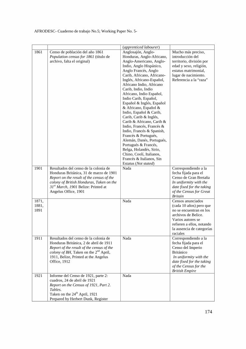
AFRODESC- Cuaderno de trabajo No.5; Working Paper No. 5-
174
(apprenticed labourer) 1861 Censo de población del año 1861
Population census for 1861 (título de archivo, falta el original)
Anglosajón, Anglo-Honduras, Anglo-Africano, Anglo-Americano, Anglo-Indio, Anglo Hispánico, Anglo Francés, Anglo Carib, Africano, Africano-Inglés, Africano-Español, Africano Indio, Africano Carib, Indio, Indio Africano, Indio Español, Indio Carib, Español, Español & Inglés, Español & Africano, Español & Indio, Español & Carib, Carib, Carib & Inglés, Carib & Africano, Carib & Indio, Francés, Francés & Indio, Francés & Spanish, Francés & Portugués, Alemán, Danés, Portugués, Portugués & Francés, Belga, Holandés, Sirio, Chino, Coolí, Italianos, Francés & Italianos, Sin Estatus (Not stated)
Mucho más preciso, introducción del territorio, división por edad y sexo, religión, estatus matrimonial, lugar de nacimiento. Referencia a la “raza”
1901 Resultados del censo de la colonia de Honduras Británica, 31 de marzo de 1901 Report on the result of the census of the colony of British Honduras, Taken on the 31st March, 1901 Belize: Printed at Angelus Office, 1901
Nada Correspondiendo a la fecha fijada para el Censo de Gran Bretaña In uniformity with the date fixed for the taking of the Census for Great Britain
1871, 1881, 1891
Nada Censos anunciados (cada 10 años) pero que no se encuentran en los archivos de Belice. Varios autores se refieren a ellos, notando la ausencia de categorías raciales
1911 Resultados del censo de la colonia de Honduras Británica, 2 de abril de 1911 Report of the result of the census of the colony of BH, Taken on the 2nd April, 1911, Belize, Printed at the Angelus Office, 1912
Nada Correspondiendo a la fecha fijada para el Censo del Imperio Británico In uniformity with the date fixed for the taking of the Census for the British Empire
1921 Informe del Censo de 1921, parte 2: cuadros, 24 de abril de 1921 Report on the Census of 1921, Part 2. Tables. Taken on the 24th April, 1921 Prepared by Herbert Dunk, Register
Nada
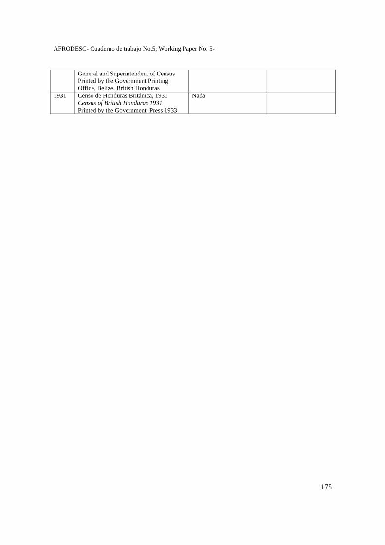
AFRODESC- Cuaderno de trabajo No.5; Working Paper No. 5-
175
General and Superintendent of Census Printed by the Government Printing Office, Belize, British Honduras
1931 Censo de Honduras Británica, 1931 Census of British Honduras 1931 Printed by the Government Press 1933
Nada
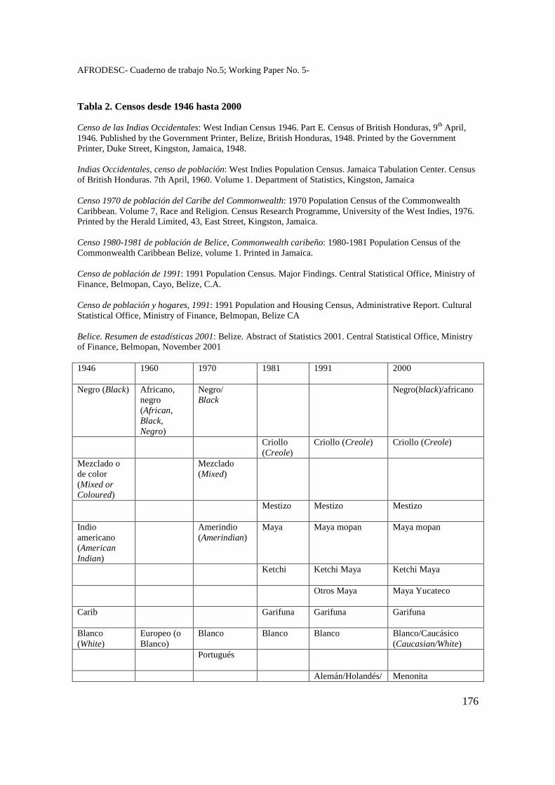
AFRODESC- Cuaderno de trabajo No.5; Working Paper No. 5-
176
Tabla 2. Censos desde 1946 hasta 2000 Censo de las Indias Occidentales: West Indian Census 1946. Part E. Census of British Honduras, 9th April, 1946. Published by the Government Printer, Belize, British Honduras, 1948. Printed by the Government Printer, Duke Street, Kingston, Jamaica, 1948. Indias Occidentales, censo de población: West Indies Population Census. Jamaica Tabulation Center. Census of British Honduras. 7th April, 1960. Volume 1. Department of Statistics, Kingston, Jamaica Censo 1970 de población del Caribe del Commonwealth: 1970 Population Census of the Commonwealth Caribbean. Volume 7, Race and Religion. Census Research Programme, University of the West Indies, 1976. Printed by the Herald Limited, 43, East Street, Kingston, Jamaica. Censo 1980-1981 de población de Belice, Commonwealth caribeño: 1980-1981 Population Census of the Commonwealth Caribbean Belize, volume 1. Printed in Jamaica. Censo de población de 1991: 1991 Population Census. Major Findings. Central Statistical Office, Ministry of Finance, Belmopan, Cayo, Belize, C.A. Censo de población y hogares, 1991: 1991 Population and Housing Census, Administrative Report. Cultural Statistical Office, Ministry of Finance, Belmopan, Belize CA Belice. Resumen de estadísticas 2001: Belize. Abstract of Statistics 2001. Central Statistical Office, Ministry of Finance, Belmopan, November 2001 1946
1960 1970 1981 1991 2000
Negro (Black) Africano, negro (African, Black, Negro)
Negro/ Black
Negro(black)/africano
Criollo (Creole)
Criollo (Creole) Criollo (Creole)
Mezclado o de color (Mixed or Coloured)
Mezclado (Mixed)
Mestizo Mestizo Mestizo
Indio americano (American Indian)
Amerindio (Amerindian)
Maya
Maya mopan Maya mopan
Ketchi Ketchi Maya
Ketchi Maya
Otros Maya
Maya Yucateco
Carib Garifuna Garifuna
Garifuna
Blanco (White)
Europeo (o Blanco)
Blanco Blanco Blanco Blanco/Caucásico (Caucasian/White)
Portugués
Alemán/Holandés/ Menonita
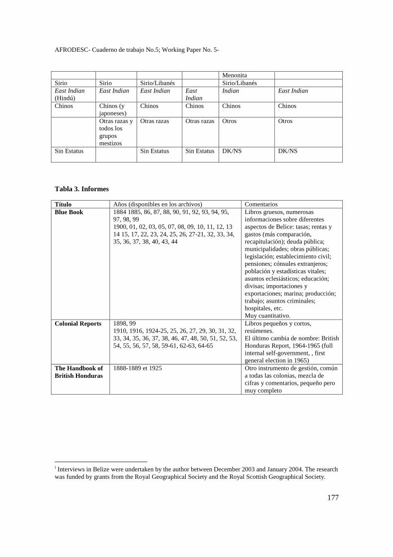
AFRODESC- Cuaderno de trabajo No.5; Working Paper No. 5-
177
Menonita Sirio Sirio Sirio/Libanés Sirio/Libanés East Indian (Hindú)
East Indian East Indian East Indian
Indian
East Indian
Chinos Chinos (y japoneses)
Chinos Chinos Chinos Chinos
Otras razas y todos los grupos mestizos
Otras razas Otras razas Otros
Otros
Sin Estatus Sin Estatus Sin Estatus DK/NS
DK/NS
Tabla 3. Informes Título Años (disponibles en los archivos) Comentarios Blue Book
1884 1885, 86, 87, 88, 90, 91, 92, 93, 94, 95, 97, 98, 99 1900, 01, 02, 03, 05, 07, 08, 09, 10, 11, 12, 13 14 15, 17, 22, 23, 24, 25, 26, 27-21, 32, 33, 34, 35, 36, 37, 38, 40, 43, 44
Libros gruesos, numerosas informaciones sobre diferentes aspectos de Belice: tasas; rentas y gastos (más comparación, recapitulación); deuda pública; municipalidades; obras públicas; legislación; establecimiento civil; pensiones; cónsules extranjeros; población y estadísticas vitales; asuntos eclesiásticos; educación; divisas; importaciones y exportaciones; marina; producción; trabajo; asuntos criminales; hospitales, etc. Muy cuantitativo.
Colonial Reports
1898, 99 1910, 1916, 1924-25, 25, 26, 27, 29, 30, 31, 32, 33, 34, 35, 36, 37, 38, 46, 47, 48, 50, 51, 52, 53, 54, 55, 56, 57, 58, 59-61, 62-63, 64-65
Libros pequeños y cortos, resúmenes. El último cambia de nombre: British Honduras Report, 1964-1965 (full internal self-government, , first general election in 1965)
The Handbook of British Honduras
1888-1889 et 1925 Otro instrumento de gestión, común a todas las colonias, mezcla de cifras y comentarios, pequeño pero muy completo
i Interviews in Belize were undertaken by the author between December 2003 and January 2004. The research was funded by grants from the Royal Geographical Society and the Royal Scottish Geographical Society.