David Roma-Dollase Manuel Hernández-Pajares 7 St. Patrick ...
1
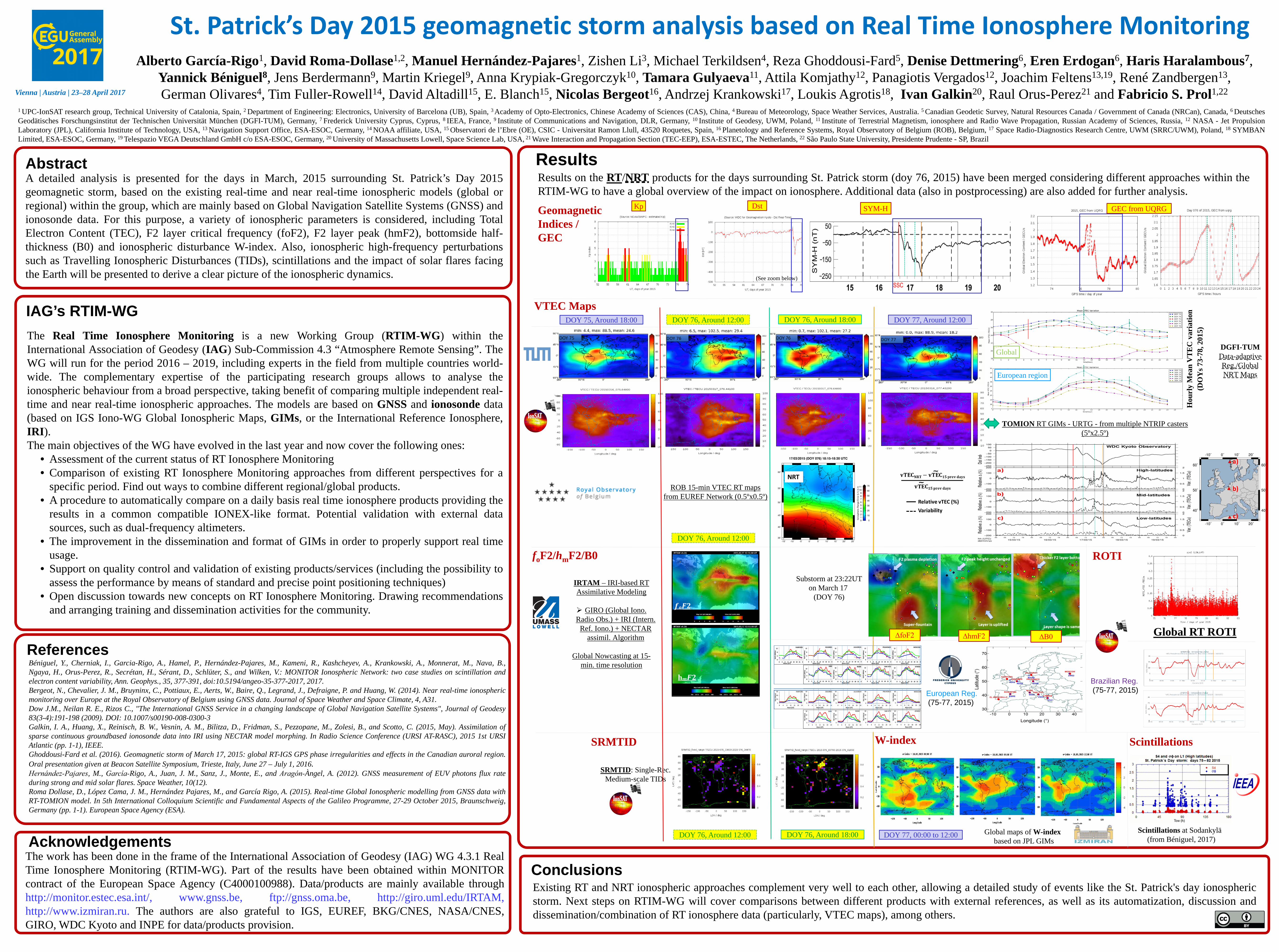
St. Patrick’s Day 2015 geomagnetic storm analysis based on Real Time Ionosphere Monitoring Alberto García-Rigo 1 , David Roma-Dollase 1,2 , Manuel Hernández-Pajares 1 , Zishen Li 3 , Michael Terkildsen 4 , Reza Ghoddousi-Fard 5 , Denise Dettmering 6 , Eren Erdogan 6 , Haris Haralambous 7 , Yannick Béniguel 8 , Jens Berdermann 9 , Martin Kriegel 9 , Anna Krypiak-Gregorczyk 10 , Tamara Gulyaeva 11 , Attila Komjathy 12 , Panagiotis Vergados 12 , Joachim Feltens 13,19 , René Zandbergen 13 , German Olivares 4 , Tim Fuller-Rowell 14 , David Altadill 15 , E. Blanch 15 , Nicolas Bergeot 16 , Andrzej Krankowski 17 , Loukis Agrotis 18 , Ivan Galkin 20 , Raul Orus-Perez 21 and Fabricio S. Prol 1,22 Abstract IAG’s RTIM-WG A detailed analysis is presented for the days in March, 2015 surrounding St. Patrick’s Day 2015 geomagnetic storm, based on the existing real-time and near real-time ionospheric models (global or regional) within the group, which are mainly based on Global Navigation Satellite Systems (GNSS) and ionosonde data. For this purpose, a variety of ionospheric parameters is considered, including Total Electron Content (TEC), F2 layer critical frequency (foF2), F2 layer peak (hmF2), bottomside half- thickness (B0) and ionospheric disturbance W-index. Also, ionospheric high-frequency perturbations such as Travelling Ionospheric Disturbances (TIDs), scintillations and the impact of solar flares facing the Earth will be presented to derive a clear picture of the ionospheric dynamics. Results References Béniguel, Y., Cherniak, I., Garcia-Rigo, A., Hamel, P., Hernández-Pajares, M., Kameni, R., Kashcheyev, A., Krankowski, A., Monnerat, M., Nava, B., Ngaya, H., Orus-Perez, R., Secrétan, H., Sérant, D., Schlüter, S., and Wilken, V.: MONITOR Ionospheric Network: two case studies on scintillation and electron content variability, Ann. Geophys., 35, 377-391, doi:10.5194/angeo-35-377-2017, 2017. Bergeot, N., Chevalier, J. M., Bruyninx, C., Pottiaux, E., Aerts, W., Baire, Q., Legrand, J., Defraigne, P. and Huang, W. (2014). Near real-time ionospheric monitoring over Europe at the Royal Observatory of Belgium using GNSS data. Journal of Space Weather and Space Climate, 4, A31. Dow J.M., Neilan R. E., Rizos C., "The International GNSS Service in a changing landscape of Global Navigation Satellite Systems", Journal of Geodesy 83(3-4):191-198 (2009). DOI: 10.1007/s00190-008-0300-3 Galkin, I. A., Huang, X., Reinisch, B. W., Vesnin, A. M., Bilitza, D., Fridman, S., Pezzopane, M., Zolesi, B., and Scotto, C. (2015, May). Assimilation of sparse continuous groundbased ionosonde data into IRI using NECTAR model morphing. In Radio Science Conference (URSI AT-RASC), 2015 1st URSI Atlantic (pp. 1-1), IEEE. Ghoddousi-Fard et al. (2016). Geomagnetic storm of March 17, 2015: global RT-IGS GPS phase irregularities and effects in the Canadian auroral region. Oral presentation given at Beacon Satellite Symposium, Trieste, Italy, June 27 – July 1, 2016. Hernández‐Pajares, M., García‐Rigo, A., Juan, J. M., Sanz, J., Monte, E., and Aragón‐Àngel, A. (2012). GNSS measurement of EUV photons flux rate during strong and mid solar flares. Space Weather, 10(12). Roma Dollase, D., López Cama, J. M., Hernández Pajares, M., and García Rigo, A. (2015). Real-time Global Ionospheric modelling from GNSS data with RT-TOMION model. In 5th International Colloquium Scientific and Fundamental Aspects of the Galileo Programme, 27-29 October 2015, Braunschweig, Germany (pp. 1-1). European Space Agency (ESA). The work has been done in the frame of the International Association of Geodesy (IAG) WG 4.3.1 Real Time Ionosphere Monitoring (RTIM-WG). Part of the results have been obtained within MONITOR contract of the European Space Agency (C4000100988). Data/products are mainly available through http://monitor.estec.esa.int/, www.gnss.be, ftp://gnss.oma.be, http://giro.uml.edu/IRTAM, http://www.izmiran.ru. The authors are also grateful to IGS, EUREF, BKG/CNES, NASA/CNES, GIRO, WDC Kyoto and INPE for data/products provision. Acknowledgements 1 UPC-IonSAT research group, Technical University of Catalonia, Spain, 2 Department of Engineering: Electronics, University of Barcelona (UB), Spain, 3 Academy of Opto-Electronics, Chinese Academy of Sciences (CAS), China, 4 Bureau of Meteorology, Space Weather Services, Australia. 5 Canadian Geodetic Survey, Natural Resources Canada / Government of Canada (NRCan), Canada, 6 Deutsches Geodätisches Forschungsinstitut der Technischen Universität München (DGFI-TUM), Germany, 7 Frederick University Cyprus, Cyprus, 8 IEEA, France, 9 Institute of Communications and Navigation, DLR, Germany, 10 Institute of Geodesy, UWM, Poland, 11 Institute of Terrestrial Magnetism, ionosphere and Radio Wave Propagation, Russian Academy of Sciences, Russia, 12 NASA - Jet Propulsion Laboratory (JPL), California Institute of Technology, USA, 13 Navigation Support Office, ESA-ESOC, Germany, 14 NOAA affiliate, USA, 15 Observatori de l’Ebre (OE), CSIC - Universitat Ramon Llull, 43520 Roquetes, Spain, 16 Planetology and Reference Systems, Royal Observatory of Belgium (ROB), Belgium, 17 Space Radio-Diagnostics Research Centre, UWM (SRRC/UWM), Poland, 18 SYMBAN Limited, ESA-ESOC, Germany, 19 Telespazio VEGA Deutschland GmbH c/o ESA-ESOC, Germany, 20 University of Massachusetts Lowell, Space Science Lab, USA, 21 Wave Interaction and Propagation Section (TEC-EEP), ESA-ESTEC, The Netherlands, 22 São Paulo State University, Presidente Prudente - SP, Brazil Hourly Mean VTEC variation (DOYs 73-78, 2015) TOMION RT GIMs - URTG - from multiple NTRIP casters (5ºx2.5º) Results on the RT /NRT products for the days surrounding St. Patrick storm (doy 76, 2015) have been merged considering different approaches within the RTIM-WG to have a global overview of the impact on ionosphere. Additional data (also in postprocessing) are also added for further analysis. The Real Time Ionosphere Monitoring is a new Working Group (RTIM-WG) within the International Association of Geodesy (IAG) Sub-Commission 4.3 “Atmosphere Remote Sensing”. The WG will run for the period 2016 – 2019, including experts in the field from multiple countries world- wide. The complementary expertise of the participating research groups allows to analyse the ionospheric behaviour from a broad perspective, taking benefit of comparing multiple independent real- time and near real-time ionospheric approaches. The models are based on GNSS and ionosonde data (based on IGS Iono-WG Global Ionospheric Maps, GIMs, or the International Reference Ionosphere, IRI). The main objectives of the WG have evolved in the last year and now cover the following ones: • Assessment of the current status of RT Ionosphere Monitoring • Comparison of existing RT Ionosphere Monitoring approaches from different perspectives for a specific period. Find out ways to combine different regional/global products. • A procedure to automatically compare on a daily basis real time ionosphere products providing the results in a common compatible IONEX-like format. Potential validation with external data sources, such as dual-frequency altimeters. • The improvement in the dissemination and format of GIMs in order to properly support real time usage. • Support on quality control and validation of existing products/services (including the possibility to assess the performance by means of standard and precise point positioning techniques) • Open discussion towards new concepts on RT Ionosphere Monitoring. Drawing recommendations and arranging training and dissemination activities for the community. St. Patrick’s Day 2015 geomagnetic storm analysis based on Real Time Ionosphere Monitoring Vienna | Austria | 23–28 April 2017 Kp Geomagnetic Indices / GEC Dst SYM-H VTEC Maps GEC from UQRG DOY 76, Around 12:00 DOY 76, Around 18:00 DOY 77, Around 12:00 DOY 75, Around 18:00 (See zoom below) Global European region DGFI-TUM Data-adaptive Reg./Global NRT Maps ROB 15-min VTEC RT maps from EUREF Network (0.5ºx0.5º) f o F2/h m F2/B0 SRMTID Existing RT and NRT ionospheric approaches complement very well to each other, allowing a detailed study of events like the St. Patrick's day ionospheric storm. Next steps on RTIM-WG will cover comparisons between different products with external references, as well as its automatization, discussion and dissemination/combination of RT ionosphere data (particularly, VTEC maps), among others. Conclusions IRTAM – IRI-based RT Assimilative Modeling GIRO (Global Iono. Radio Obs.) + IRI (Intern. Ref. Iono.) + NECTAR assimil . Algorithm Global Nowcasting at 15- min. time resolution h ∆ ∆ ∆ Substorm at 23:22UT on March 17 (DOY 76) Scintillations at Sodankylä (from Béniguel, 2017) SRMTID : Single-Rec. Medium-scale TIDs Global RT ROTI DOY 76, Around 12:00 DOY 76, Around 18:00 DOY 77, 00:00 to 12:00 Global maps of W-index based on JPL GIMs ROTI W-index Scintillations European Reg. (75-77, 2015) Brazilian Reg. (75-77, 2015) DOY 76, Around 12:00 ∆foF2 ∆hmF2 ∆B0
Transcript of David Roma-Dollase Manuel Hernández-Pajares 7 St. Patrick ...
St. Patrick’s Day 2015 geomagnetic storm analysis based on Real Time Ionosphere MonitoringAlberto García-Rigo1, David Roma-Dollase1,2, Manuel Hernández-Pajares1, Zishen Li3, Michael Terkildsen4, Reza Ghoddousi-Fard5, Denise Dettmering6, Eren Erdogan6, Haris Haralambous7,
Yannick Béniguel8, Jens Berdermann9, Martin Kriegel9, Anna Krypiak-Gregorczyk10, Tamara Gulyaeva11, Attila Komjathy12, Panagiotis Vergados12, Joachim Feltens13,19, René Zandbergen13, German Olivares4, Tim Fuller-Rowell14, David Altadill15, E. Blanch15, Nicolas Bergeot16, Andrzej Krankowski17, Loukis Agrotis18, Ivan Galkin20, Raul Orus-Perez21 and Fabricio S. Prol1,22
Abstract
IAG’s RTIM-WG
A detailed analysis is presented for the days in March, 2015 surrounding St. Patrick’s Day 2015geomagnetic storm, based on the existing real-time and near real-time ionospheric models (global orregional) within the group, which are mainly based on Global Navigation Satellite Systems (GNSS) andionosonde data. For this purpose, a variety of ionospheric parameters is considered, including TotalElectron Content (TEC), F2 layer critical frequency (foF2), F2 layer peak (hmF2), bottomside half-thickness (B0) and ionospheric disturbance W-index. Also, ionospheric high-frequency perturbationssuch as Travelling Ionospheric Disturbances (TIDs), scintillations and the impact of solar flares facingthe Earth will be presented to derive a clear picture of the ionospheric dynamics.
Results
ReferencesBéniguel, Y., Cherniak, I., Garcia-Rigo, A., Hamel, P., Hernández-Pajares, M., Kameni, R., Kashcheyev, A., Krankowski, A., Monnerat, M., Nava, B.,Ngaya, H., Orus-Perez, R., Secrétan, H., Sérant, D., Schlüter, S., and Wilken, V.: MONITOR Ionospheric Network: two case studies on scintillation andelectron content variability, Ann. Geophys., 35, 377-391, doi:10.5194/angeo-35-377-2017, 2017.Bergeot, N., Chevalier, J. M., Bruyninx, C., Pottiaux, E., Aerts, W., Baire, Q., Legrand, J., Defraigne, P. and Huang, W. (2014). Near real-time ionosphericmonitoring over Europe at the Royal Observatory of Belgium using GNSS data. Journal of Space Weather and Space Climate, 4, A31.Dow J.M., Neilan R. E., Rizos C., "The International GNSS Service in a changing landscape of Global Navigation Satellite Systems", Journal of Geodesy83(3-4):191-198 (2009). DOI: 10.1007/s00190-008-0300-3Galkin, I. A., Huang, X., Reinisch, B. W., Vesnin, A. M., Bilitza, D., Fridman, S., Pezzopane, M., Zolesi, B., and Scotto, C. (2015, May). Assimilation ofsparse continuous groundbased ionosonde data into IRI using NECTAR model morphing. In Radio Science Conference (URSI AT-RASC), 2015 1st URSIAtlantic (pp. 1-1), IEEE.Ghoddousi-Fard et al. (2016). Geomagnetic storm of March 17, 2015: global RT-IGS GPS phase irregularities and effects in the Canadian auroral region.Oral presentation given at Beacon Satellite Symposium, Trieste, Italy, June 27 – July 1, 2016.Hernández‐Pajares, M., García‐Rigo, A., Juan, J. M., Sanz, J., Monte, E., and Aragón‐Àngel, A. (2012). GNSS measurement of EUV photons flux rateduring strong and mid solar flares. Space Weather, 10(12).Roma Dollase, D., López Cama, J. M., Hernández Pajares, M., and García Rigo, A. (2015). Real-time Global Ionospheric modelling from GNSS data withRT-TOMION model. In 5th International Colloquium Scientific and Fundamental Aspects of the Galileo Programme, 27-29 October 2015, Braunschweig,Germany (pp. 1-1). European Space Agency (ESA).
The work has been done in the frame of the International Association of Geodesy (IAG) WG 4.3.1 RealTime Ionosphere Monitoring (RTIM-WG). Part of the results have been obtained within MONITORcontract of the European Space Agency (C4000100988). Data/products are mainly available throughhttp://monitor.estec.esa.int/, www.gnss.be, ftp://gnss.oma.be, http://giro.uml.edu/IRTAM,http://www.izmiran.ru. The authors are also grateful to IGS, EUREF, BKG/CNES, NASA/CNES,GIRO, WDC Kyoto and INPE for data/products provision.
Acknowledgements
1 UPC-IonSAT research group, Technical University of Catalonia, Spain, 2 Department of Engineering: Electronics, University of Barcelona (UB), Spain, 3 Academy of Opto-Electronics, Chinese Academy of Sciences (CAS), China, 4 Bureau of Meteorology, Space Weather Services, Australia. 5 Canadian Geodetic Survey, Natural Resources Canada / Government of Canada (NRCan), Canada, 6 DeutschesGeodätisches Forschungsinstitut der Technischen Universität München (DGFI-TUM), Germany, 7 Frederick University Cyprus, Cyprus, 8 IEEA, France, 9 Institute of Communications and Navigation, DLR, Germany, 10 Institute of Geodesy, UWM, Poland, 11 Institute of Terrestrial Magnetism, ionosphere and Radio Wave Propagation, Russian Academy of Sciences, Russia, 12 NASA - Jet PropulsionLaboratory (JPL), California Institute of Technology, USA, 13 Navigation Support Office, ESA-ESOC, Germany, 14 NOAA affiliate, USA, 15 Observatori de l’Ebre (OE), CSIC - Universitat Ramon Llull, 43520 Roquetes, Spain, 16 Planetology and Reference Systems, Royal Observatory of Belgium (ROB), Belgium, 17 Space Radio-Diagnostics Research Centre, UWM (SRRC/UWM), Poland, 18 SYMBANLimited, ESA-ESOC, Germany, 19 Telespazio VEGA Deutschland GmbH c/o ESA-ESOC, Germany, 20 University of Massachusetts Lowell, Space Science Lab, USA, 21 Wave Interaction and Propagation Section (TEC-EEP), ESA-ESTEC, The Netherlands, 22 São Paulo State University, Presidente Prudente - SP, Brazil
Hou
rly
Mea
n V
TE
C v
aria
tion
(DO
Ys 7
3-78
, 201
5)
TOMION RT GIMs - URTG - from multiple NTRIP casters(5ºx2.5º)
Results on the RT/NRT products for the days surrounding St. Patrick storm (doy 76, 2015) have been merged considering different approaches within theRTIM-WG to have a global overview of the impact on ionosphere. Additional data (also in postprocessing) are also added for further analysis.
The Real Time Ionosphere Monitoring is a new Working Group (RTIM-WG) within theInternational Association of Geodesy (IAG) Sub-Commission 4.3 “Atmosphere Remote Sensing”. TheWG will run for the period 2016 – 2019, including experts in the field from multiple countries world-wide. The complementary expertise of the participating research groups allows to analyse theionospheric behaviour from a broad perspective, taking benefit of comparing multiple independent real-time and near real-time ionospheric approaches. The models are based on GNSS and ionosonde data(based on IGS Iono-WG Global Ionospheric Maps, GIMs, or the International Reference Ionosphere,IRI).The main objectives of the WG have evolved in the last year and now cover the following ones:
• Assessment of the current status of RT Ionosphere Monitoring• Comparison of existing RT Ionosphere Monitoring approaches from different perspectives for a
specific period. Find out ways to combine different regional/global products.• A procedure to automatically compare on a daily basis real time ionosphere products providing the
results in a common compatible IONEX-like format. Potential validation with external datasources, such as dual-frequency altimeters.
• The improvement in the dissemination and format of GIMs in order to properly support real timeusage.
• Support on quality control and validation of existing products/services (including the possibility toassess the performance by means of standard and precise point positioning techniques)
• Open discussion towards new concepts on RT Ionosphere Monitoring. Drawing recommendationsand arranging training and dissemination activities for the community.
St. Patrick’s Day 2015 geomagnetic storm analysis based on Real Time Ionosphere Monitoring
Vienna | Austria | 23–28 April 2017
KpGeomagneticIndices / GEC
Dst SYM-H
VTEC Maps
GEC from UQRG
DOY 76, Around 12:00 DOY 76, Around 18:00 DOY 77, Around 12:00DOY 75, Around 18:00
(See zoom below)
Global
European region
DGFI-TUMData-adaptive Reg./Global NRT Maps
ROB 15-min VTEC RT mapsfrom EUREF Network (0.5ºx0.5º)
foF2/hmF2/B0
SRMTID
Existing RT and NRT ionospheric approaches complement very well to each other, allowing a detailed study of events like the St. Patrick's day ionosphericstorm. Next steps on RTIM-WG will cover comparisons between different products with external references, as well as its automatization, discussion anddissemination/combination of RT ionosphere data (particularly, VTEC maps), among others.
Conclusions
IRTAM – IRI-based RT Assimilative Modeling
GIRO (Global Iono. Radio Obs.) + IRI (Intern.
Ref. Iono.) + NECTAR assimil. Algorithm
Global Nowcasting at 15-min. time resolution
𝒇𝒇𝒐𝒐𝑭𝑭𝑭𝑭
h𝒎𝒎𝑭𝑭𝑭𝑭
∆𝒇𝒇𝒐𝒐𝑭𝑭𝑭𝑭 ∆𝒉𝒉𝒎𝒎𝑭𝑭𝑭𝑭 ∆𝐁𝐁𝟎𝟎
Substorm at 23:22UTon March 17
(DOY 76)
Scintillations at Sodankylä(from Béniguel, 2017)
SRMTID: Single-Rec. Medium-scale TIDs
Global RT ROTI
DOY 76, Around 12:00 DOY 76, Around 18:00 DOY 77, 00:00 to 12:00 Global maps of W-indexbased on JPL GIMs
ROTI
W-index Scintillations
European Reg.(75-77, 2015)
Brazilian Reg.(75-77, 2015)
DOY 76, Around 12:00
∆foF2 ∆hmF2 ∆B0