The Ancestral Lands and Waters of the Indigenous Tagbanwa ...
29
The Ancestral Lands and Waters of the Indigenous Tagbanwa Communities of Northern Palawan
Transcript of The Ancestral Lands and Waters of the Indigenous Tagbanwa ...
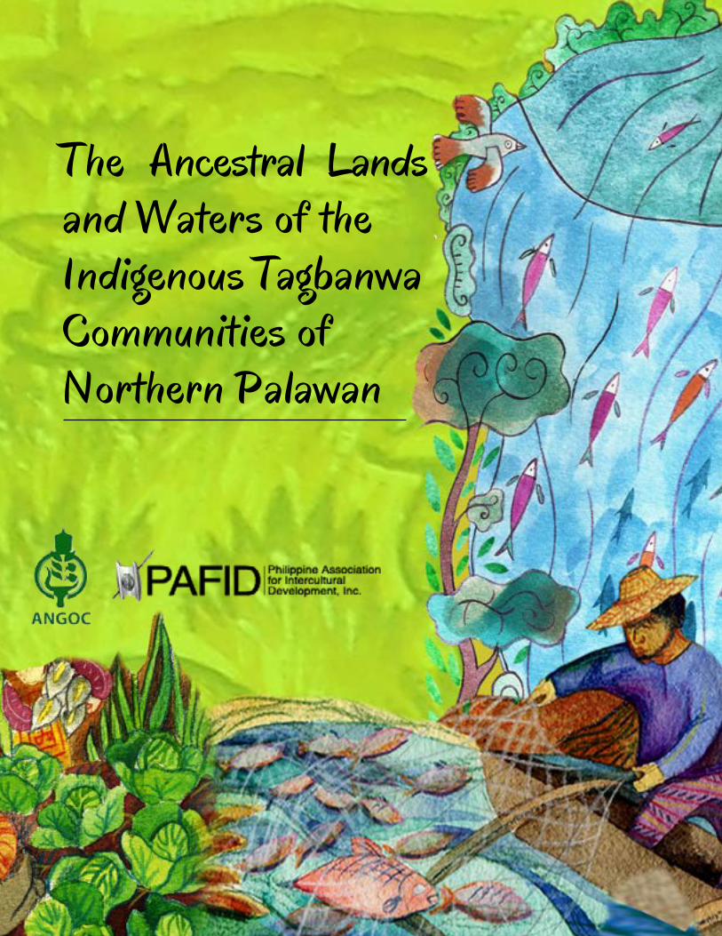
The Ancestral Lands and Waters of theIndigenous Tagbanwa Communities of Northern Palawan
Asian NGO Coalition for Agrarian Reform and Rural Development33 Mapagsangguni StreetSikatuna Village, Diliman1101 Quezon City, Philippines
P.O. Box 3107, QCCPO 1101, Quezon City, PhilippinesTel: +63-2 3510481 Fax: +63-2 3510011Email: [email protected]: www.angoc.org
Facebook: www.facebook.com/AsianNGOCoalitionTwitter: https://twitter.com/ANGOCorgSkype: asianngocoalition
Founded in 1979, ANGOC is a regional association of national and regional networks of non-govern-ment organizations (NGOs) in Asia actively engaged in food security, agrarian reform, sustainable agri-culture, participatory governance, and rural devel-opment. ANGOC network members and partners work in 14 Asian countries with an effective reach of some 3,000 NGOs and community-based organiza-tions (CBOs). ANGOC actively engages in joint field programs and policy debates with national govern-ments, intergovernmental organizations (IGOs), and international financial institutions (IFIs).
ANGOC is the convenor of the Land Watch Asia (LWA) campaign. ANGOC is also a member of the International Land Coalition (ILC) and the Global Land Tool Network (GLTN).
Philippine Association for Intercul-tural Development, Inc.71 Malakas StreetTeachers’ Village, Diliman1101 Quezon City, Philippines
Tel: +63-2 9274580 Fax: +63-2 9274580Email: [email protected]
Facebook: www.facebook.com/Philippine-As-sociation-for-Intercultural-Development-PA-FID-198741346805024/
PAFID is a social development organization which has assisting Philippine indigenous communities regain and secure their traditional lands and water since 1967. It forms institutional partnerships with indigenous communities to secure legal ownership over ancestral domains and to shape government policy over indigenous peoples’ issues. PAFID envi-sions indigenous communities as responsible stew-ards of their resources.
The Ancestral Lands and Waters of the Indigenous Tagbanwa
Communities of Northern Palawan1,2
Prepared by
Dave De Vera & Kail ZingapanPhilippine Association for Intercultural Development, Inc. (PAFID)
in behalf of the Asian NGO Coalition for Agrarian Reform and Rural Development (ANGOC)
for the project entitled “Mainstreaming Voluntary Guidelines on Governance of Tenure (VGGT): Philippines”
supported by the Food and Agriculture Organization (FAO)3 of the United Nations
October 2017
ii
Citation:
De Vera, D. and Zingapan, K. (2017). The Ancestral Lands and Waters of the Indigenous Tagbanwa Communities of Northern Palawan. Quezon City: Asian NGO Coalition for Agrarian Reform and Rural Development (ANGOC).
Disclaimer:
The views presented in this document do not necessarily reflect those of FAO.
AcronymsADMP Ancestral Domain Management PlanADSDPP Ancestral Domain Sustainable Development and Protection PlanCADC Certificate of Ancestral Domain ClaimCADT Certificate of Ancestral Domain TitleCLUP Comprehensive Land Use PlanCFSA Community Forest Stewardship AgreementCOFI Committee on FisheriesDA Department of AgricultureDAO #02 Department Administrative Order No. 02, Series of 1992DENR Department of Environment and Natural ResourcesFARMC Fisheries and Aquatic Resources Management CouncilICC indigenous cultural communityIKSPs indigenous knowledge systems and practices IPs indigenous peoplesIPO indigenous peoples organizationIPRA Indigenous Peoples Rights ActKASAPI Katutubong Samahan ng PilipinasLGU local government unitNAMRIA National Mapping and Resource Information AuthorityNFARMC National Fisheries and Aquatic Resources Management CouncilNCIP National Commission on Indigenous PeoplesNCIPP National Coalition of Indigenous Peoples in the PhilippinesNGO non-government organizationPAFID Philippine Association for Intercultural Development, Inc.PCSD Palawan Council for Sustainable DevelopmentPSTFAD Provincial Special Task Force on Ancestral DomainsRA Republic ActSARAGPUNTA (Panag-Saragpun) Coming Together TFCI Tagbanwa Foundation of Coron IslandUNDRIP United Nations Declaration on the Rights of Indigenous Peoples
1
OverviewVGSSF Framework and its status in the Philippines
The Voluntary Guidelines for Securing Sustainable Small-Scale Fisheries in the Context of Food Security and Poverty Eradication (VGSSF) have been developed as complement to the 1995 FAO Code of Conduct for Responsible Fisheries (the Code). These were developed to provide complementary guidance with respect to small-scale fisheries in support of the overall principles and provisions of the Code.
The development of the Guidelines was initiated in 2008 during the First Global Conference on Small-Scale Fisheries in Bangkok, Thailand and it was finally endorsed at the 31st Session of the FAO Committee on Fisheries (COFI) in June 2014. The VGSSF are instruments for sustainable development as well as for supporting food security and nutritional intake, equitable development and poverty eradication, and responsible management of fisheries resources.
The VGSSF was developed through a participatory and consultative process, directly involving more than 4,000 representatives of small-scale fishing communities, civil society organizations (CSOs), governments, regional organizations and other stakeholders from more than 120 countries. The VGSSF are voluntary, global in scope and with a focus on the needs of developing countries. It emphasizes the important role of small-scale fisheries for food security and poverty eradication: a source of nutrition, income and economic growth.
Existing Policies and Laws and Mechanisms/structures on the Fishery Sector in Northern Palawan4
1. Republic Act No. 8550, otherwise known as the “The Philippine Fisheries Code of 1998,” serves as the National Policy of the Fishery Sector. The Fishery Code aims to improve the productivity of the country’s fishery sector and provide conservation and protection to aquatic resources. It’s main objectives include the following:
• Conservation, protection and sustained management of the country’s fishery and aquatic resources;
• Poverty alleviation and the provision of supplementary livelihood among municipal fisherfolk;• Improvement of productivity of aquaculture within ecological limits;• Optimal utilization of off-shore and deep-sea resources; and,• Upgrading of post-harvest technology. The Fisheries Code mandates that the following provisions shall be enforced to (i) all Philippine waters, (ii) all aquatic and fishery resources including inland, coastal and offshore fishing areas, and (iii) all lands devoted aquaculture businesses whether private or public lands.
2
3
2. The Local Government Code (RA 7160) of 1991
Republic Act 7160 defines the nature, coverage and the regulatory functions of the LGU in the governance and management of coverage of “municipal waters.” Moreover, RA 7160 also provides the rules for fishery rentals, fees and charges and provides the mandate to the Local Government Unit to have the “exclusive authority” to grant such fishery privileges and impose and collect fees thereof.
3. RA 8371 or the Indigenous Peoples Rights Act of 1997
Passed in 1997, the IPRA defines the nature and coverage of Ancestral Domains of Indigenous Communities. Under SECTION 3. Definition of Terms of IPRA, ‘ancestral domains’ refer to “all areas, generally belonging to ICCs/IPs comprising land water, coastal areas, and natural resources therein.” IPRA provides the legal basis for the inclusion of “ancestral waters” in the filing of Ancestral Domains Claims.
4. Republic Act 7611 or the Strategic Environment Plan for Palawan (SEP)
A special law enacted in 1992 to provide an over-all blueprint for the conservation and management of the province of Palawan. The SEP law pursues the “sustainable development of the province of Palawan” by adopting a zoning scheme called the Environmentally Critical Areas Network or ECAN as its main strategy. Section 7 defines the ECAN as
“
“… a graded system of protection and development control over the whole of Palawan, including its tribal lands, forests, mines, agricultural areas, settlement areas, small islands, mangroves, coral reefs, seagrass beds and the surrounding sea.”
The SEP identifies “tribal ancestral lands” as one of the three main components of the ECAN5
and defines “tribal ancestral lands” in Section 3 as “… areas comprising both land and sea that are traditionally occupied by the cultural minorities.” The SEP in Sec. 11 underlines the primacy of cultural criteria in zoning “tribal ancestral lands.”
5. Indigenous Resource Management Rules and Mechanisms
The role of the elders and parents are highly valued and respected in the Tagbanwa society. The mepet (elders) are traditionally consulted on matters affecting the clans and on important issues affecting communities. It was the mepet who prescribed sanctions and meted out penalties for infractions against customary laws, prescriptions that were handed down orally from one generation to the next. The mepet settled disputes on ancestral lands and set the rules for resource extraction. Hence, in the past, the mepet were held in high regard for their knowledge of customary laws and played important roles in decision-making for the community.
The mepet define the reserved areas including the “no-go” zones or “panyaan” as well as the open access resource utilization areas in the ancestral waters. The panyaan are marine areas, which are traditionally avoided by Tagbanwa because of a belief that certain areas are sensitive or remain under the influence of an unseen, spirit world. The direct counterpart of the panyaan on land are the amlaran which are also areas that are known to be inhabited by spirits which can wrought potential harm to human beings, such as to cause sickness and the like. The amlaran are separate from the awuyuk or sacred lakes in Coron, which are also believed to be inhabited by spirits in the form of giant octopuses and ergo, are only used following strict observances, such as limiting one’s speech or using an entirely separate language used only in the awuyuks.
These reserved areas are not coincidentally ecologically intact and sensitive areas. The awuyuks for example are part of Coron Island’s precious watershed and shelter the swiftlet caves, which are so valuable to the Tagbanwa income. The panyaan too are areas, which remain pristine and not a few, are adjacent to fish hatcheries or sanctuaries.
Objectives and Scope
This case study aims to contextualize the issues identified in the Scoping Paper on VGSSF and the Philippine Policies and Laws on Fisheries, as well as offer local-level recommendations to the issues. These issues highlighted in the case also reflect a number of concerns raised by fisherfolk organizations and CSOs in various policy dialogues.
This paper focuses on the Calamian Tagbanwa and their initiative to map their ancestral lands and waters as part of a strategy to secure or regain tenure and assert their resource rights within their ancestral domain. In 1997, the Tagbanwa communities initiated mapping activities to facilitate the self-delineation of their ancestral domains and to file claims over the land and waters. Under the principle of self-determination, ICCs/IPs shall define the boundaries and coverage of their ancestral domains, which may include terrestrial as well as aquatic resources. Furthermore, they have the right to formulate their own sustainable development and management plans for the land and natural resources within their ancestral domains based on their indigenous knowledge and practices. As the IP communities become stewards of the island, they are now the managers of the eco-tourism in the area.
Area and Focus of the Study
The study discusses the ancestral waters of the Calamian Tagbanwa of Northern Palawan. From the point of view of ethno-linguistics, there are three groups of Tagbanwa geographically distinguished as northern, central and southern. In the technical literature, the northern group is referred to as the Calamian Tagbanwa who inhabit various islands in the Calamian and Linapacan groups and areas in the northern part of the main island of Palawan. The central group inhabit an area further south on the mainland in the vicinity of Roxas and are sometimes referred to as Silanganen. Lastly, the southernmost
6
5
group is known simply as Tagbanwa, and they inhabit areas to the south of the central Tagbanwa area. These three groups are quite distinct from one another primarily because their languages are widely different and incomprehensible to the other groups. Secondly, unlike the southern group of shifting cultivators described by Robert B. Fox, the Calamian Tagbanwa are chiefly seminomadic fisherfolks.6
The name “Tagbanwa” is a generic one and means “from the place” or “original inhabitants of the place.” It is still used today by the indigenous or native population to distinguish themselves from the lumalayag (sailors) or “those who migrated to the area by sea” like the Cuyonon and other Hispanicized Filipinos such as Agutaynon, Cagayanen, and the Visayans.
The methods used in the investigation are: 1) semi-structured interviews with key informants, such as community elders, leaders of the indigenous organizations, barangay captains and NGO field workers; 2) focus group discussions with barangay officials and leaders of the indigenous organizations; and 3) key informants’ verification of the case’s final form.
Coron Island
Coron Island has a special place not only in Tagbanwa history but also in the history of the municipality itself. In an interesting twist, the town took its name after this adjacent island and not the other way around. The name “Coron” is a Cuyonon word for a round-shaped, clay cooking pot, which is what the valley in Banwang Daan looks like when seen from the vantage point of the limestone cliffs, which surround the village on three sides. The town of Coron was so named because the town site was first established in Coron Island in the mid-1700’s as Peñon de Coron located in Banwang Daan (or in the Palawan Historical Data Papers Banwang Lague) which means “former site” in Hiligaynon.
Area Profile
Coron Island is host to two villages located in Barangays Cabugao and Banwang Daan, both of which are populated predominantly by Tagbanwa. Though the majority of Tagbanwa in this island congregate in the two settlements, not a few clans live apart in scattered beaches and coves around Coron Island and Delian Island.
Three such areas are Alimpiu, Diknay, and Salamagi – all sitios of Barangay Cabugao. Salamagi is so named owing to the numerous salamagi (tamarind) trees planted in the place. It is a strip of beach in the west coast of Coron Island facing Bulalacao and Culion and has been home to the Manuel clan for several generations, that is, “simula pa sa panahon ng mga ninuno” (since the time of the ancestors). Five families from this clan have settled here permanently, and had cultivated crops along the beach such as coconuts, bananas and cassava. Close to Salamagi is the Tewa, a beach once, which is used as a burial area by the ancestors. There are many burial grounds in the beaches ringing Coron Island such as Lelebngan nye bukidnun, Magtatangaw, Indanan, Dinalak and Dima. In caves which have been relatively less disturbed by robbers, there are pieces of pottery, utensils, plates and other artifacts, as it was the custom of their ancestors to bury their dead with a few of the possessions they acquired in life. There has been some interest on the part
of the National Museum to initiate an organized archaeological study for these caves but these were not carried out possibly due to lack of funds and, as a Bulalacao elder explains, “Bawal galawin ang mga libingan sa kultura namin” (It is forbidden in our culture to disturb the graves.) The limestone cliffs ringing Coron Island are dug for kapari and kurut or burot in Tagalog, the edible roots which were staples of the Tagbanwa diet before rice was preferred and are still depended on when rice is scarce. Kurut is poisonous if its toxic sap is not hydrated and extracted. Another plant that can be foraged from the cliffs is the patuyu which is collected in May and tastes like biscuit. The Tagbanwa also collect medicinal plants found in the crags of the limestone cliffs as well as in the interior forest.
Though Bàto extends to over 7,000 hectares, it is covered by mostly limestone cliffs, forestland and the awuyuk or lalaguna (interior lakes found in sinkholes atop the cliffs). The latter are features unique to this island and are viewed by the Tagbanwa as “sagradu” or “kinatatakutan” (sacred or feared). Indeed, community leaders stressed that the awuyuk are pinaka-sagradu sa mga sagradung lugar (the most feared among the forbidden places). In crossing the awuyuk to gather swiftlet nests, the Tagbanwa either remain silent or talk in a special language reserved only for conversing in areas within the awuyuk. In their experience, gigantic octopuses live at the bottom of the awuyuks; and a Tagbanwa who uses forbidden speech while in the awuyuks will be pulled down by these octopuses to the bottom, never again to see the light of day.
There are similar observances for the panyaan as well, the Calamian Tagbanwa equivalent of marine core zones. A high taboo is attached to these sea areas where giant octopuses or the manlalabyut have been observed to prey on Tagbanwas using forbidden speech or otherwise act immoderately. The panyaans around Coron Island, as in other areas are generally avoided, and Tagbanwa who deign to fish or dive in a panyaan usually offer some form of appeasement to the spirits residing in the panyaan, such as gin and coins.
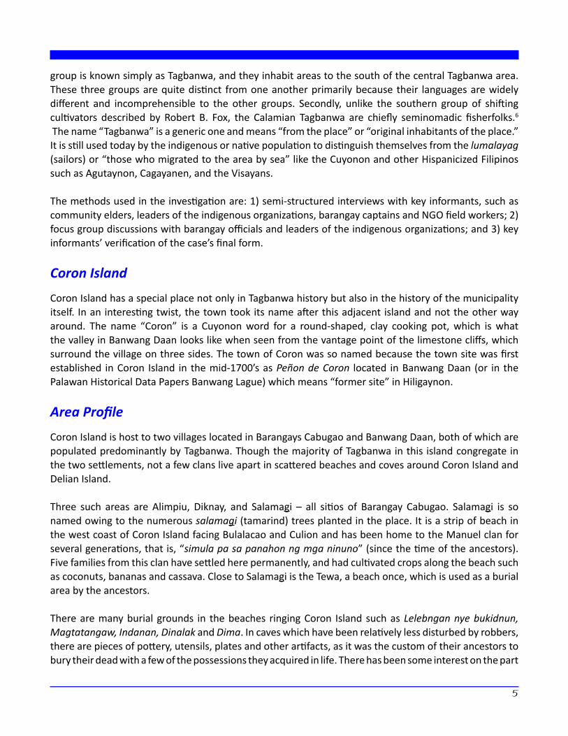
Map 1. Coron Island also known as “Batu” the line shows the extents of the ancestral waters while the dark blocks show the coral reefs that are managed by the Tagbanwa community.
6
7
In terms of agricultural production, only a few families cultivate kuma (swiddens) which are mostly planted to upland rice or corn. The kuma in Coron Island typically yields a rice harvest once a year and this takes place in October. Most families plant cashew trees in backyard lots and the nuts are sold or exchanged for rice. As local growers attest, cashew nuts from Palawan are preferred by wholesale traders based in Manila because these don’t have the bitter aftertaste found in cashews grown from other regions.
The Tagbanwa of Cabugao and Banwang Daan do not primarily depend on agriculture for their subsistence. Their real income comes from two sources: 1) fish and other aquatic resources, such as tekbeken (octopus), balat, samung, latuk (edible seaweed) and others; and 2) edible birds’ nests or luray for those who own clan caves.
Luray is used as a key ingredient in the preparation of birds’ nest soup, a delicacy in southern Chinese cuisine. Luray is derived from the nests of the balinsasayaw or swiftlet, a small and delicate bird which spins a milky, semi-transparent nest made of its own saliva, wave wash and forest litter. Swiftlets make their nests in deep caves and crags found in the limestone cliffs ringing Coron Island. These nests are very difficult to reach as the cave entrances are usually found atop great heights and can fall away from nearly vertical cliffs. Once inside, a cave can also plunge straight down and nests may be located in the pitch-dark hollows below.
Every December, the swiftlets return to the same caves to spin their nests and lay eggs. Tagbanwa families have passed on their clan caves from generation to generation and as mentioned earlier, have traded luray to Chinese and then to Cuyonon and Filipino middlemen for over 300 years.
A high value is also placed on respect for one’s elders and parents. Having vast knowledge on customary laws, the mepet (elders) are traditionally consulted on matters affecting the clans and on important issues affecting the communities.
However the introduction of the barangay system of political governance brought a profound change to their customary political structures. There was no place for the council of elders in the barangay system and the local government structure tended to centralize decision-making and services with the municipal government and with Puerto Princesa.
The demographics of Calamian Tagbanwa communities in the municipality of Coron as recorded by municipal government planning offices seem to have undergone a significant reduction between 1994 (when Saragpunta’s Certificate of Ancestral Domain Claim/CADC application was relatively less well-known to local executives) and the present.
Table 1 shows the 1995 total population of 11 barangays known to host Tagbanwa villages. Of Coron’s 23 barangays, these barangays account for 37.8 percent of the municipality’s total population.
Total population of Coron = 27,040 Total no. of barangays in Coron = 23 Total households in Coron = 5,110
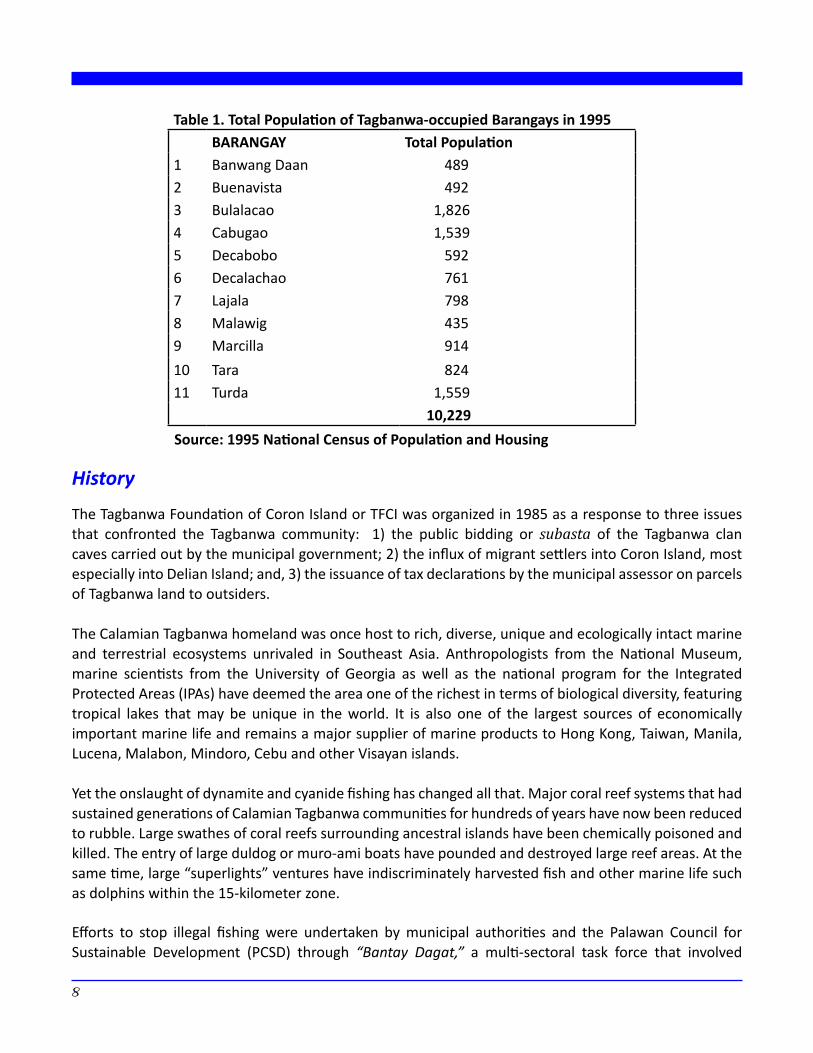
Table 1. Total Population of Tagbanwa-occupied Barangays in 1995BARANGAY Total Population
1 Banwang Daan 489 2 Buenavista 492 3 Bulalacao 1,826 4 Cabugao 1,539 5 Decabobo 592 6 Decalachao 761 7 Lajala 798 8 Malawig 435 9 Marcilla 914 10 Tara 824 11 Turda 1,559
10,229
History
The Tagbanwa Foundation of Coron Island or TFCI was organized in 1985 as a response to three issues that confronted the Tagbanwa community: 1) the public bidding or subasta of the Tagbanwa clan caves carried out by the municipal government; 2) the influx of migrant settlers into Coron Island, most especially into Delian Island; and, 3) the issuance of tax declarations by the municipal assessor on parcels of Tagbanwa land to outsiders.
The Calamian Tagbanwa homeland was once host to rich, diverse, unique and ecologically intact marine and terrestrial ecosystems unrivaled in Southeast Asia. Anthropologists from the National Museum, marine scientists from the University of Georgia as well as the national program for the Integrated Protected Areas (IPAs) have deemed the area one of the richest in terms of biological diversity, featuring tropical lakes that may be unique in the world. It is also one of the largest sources of economically important marine life and remains a major supplier of marine products to Hong Kong, Taiwan, Manila, Lucena, Malabon, Mindoro, Cebu and other Visayan islands.
Yet the onslaught of dynamite and cyanide fishing has changed all that. Major coral reef systems that had sustained generations of Calamian Tagbanwa communities for hundreds of years have now been reduced to rubble. Large swathes of coral reefs surrounding ancestral islands have been chemically poisoned and killed. The entry of large duldog or muro-ami boats have pounded and destroyed large reef areas. At the same time, large “superlights” ventures have indiscriminately harvested fish and other marine life such as dolphins within the 15-kilometer zone.
Efforts to stop illegal fishing were undertaken by municipal authorities and the Palawan Council for Sustainable Development (PCSD) through “Bantay Dagat,” a multi-sectoral task force that involved
Source: 1995 National Census of Population and Housing
8
9
law enforcement, political executives, people’s organizations and NGOs. Implementation was critically challenged at the local level due to the vast area that had to be policed; the limited resources for law enforcement; and the fact that in not a few instances, the perpetrators spent only a day or two in jail and were later released with no charges filed. After facing grave threats and personal hardship in arresting violators, many local officials from Tagbanwa barangays were soon discouraged by Bantay Dagat’s uneven enforcement within ancestral waters. Tagbanwa elders and community leaders faced the very possibility of being forced to abandon their ancestral islands as the marine environment, which had served as their life support system, was evidencing signs of severe stress. Between 1989 and 1995, the average fish catch around Tagbanwa islands had been reduced to less than half the former capacity. The diversity of fish and other marine species was also noticeably dwindling. Meanwhile, waves of migrant fisherfolk as well as large fish contractors from Lucena, Mindoro, Cebu and other Visayan islands began to overwhelm the area.
Yet graver issues were threatening the viability of their ancestral islands to support their families and communities. In the early 1970s, the municipal government of Coron announced that it was seizing all the clan caves in Coron Island and declaring them as its property. As such, all the clan caves were to be auctioned off (subasta) to raise revenue for the municipal treasury, and the winning bidder assumed ownership of the swiftlet nests harvested within. In an instant, the Tagbanwas of Coron Island were reduced from being owners and sellers to gatherers paid for their labor.
In yet another campaign to raise the tax effort of the treasury, the municipal government auctioned off tax declarations which had lapsed with their payments. Titled areas are a rarity in Coron since nearly all lands are unclassified areas of the public domain. Instead, tax declarations are issued as receipt of improvements on government land. However, certain political executives had taken the view that tax declarations were proofs of ownership of the land itself. Since most of the Tagbanwas could not afford the annual payments dictated by the municipal treasury, many of their tax declarations were auctioned off to tourist resort developers, real estate agents, and the like. The buyers, convinced that they had gained rights over the land, attempt to evict Tagbanwa families from holdings which had been occupied or used by communities since time immemorial, for example white sand beach properties.
However, in other Calamian Tagbanwa communities, tourist resort developers simply grabbed lands and evicted entire Tagbanwa sitios after securing contracts from local Department of Agrarian Reform and Rural Development (DENR) units. Pasture lease agreements issued on ancestral islands had been granted by the City of Environment and Natural Resources Office (CENRO) to local political leaders such as mayors and municipal councilors. A pattern of political patronage in exchange for contracts and permits for the extraction and use of natural resources was emerging.
From the early 1990s, the pressure on the Tagbanwa to leave their islands and give way to tourist resort owners and developers began to intensify. The entry of tourists into their homelands also caused grave concern for the safety of their children who remain free to roam the islands and forage for food without fear.
Community responses
As an immediate response to the auction of the clan caves, barangays Banwang Daan and Cabugao organized themselves into the Tagbanwa Foundation of Coron Island (TFCI). In 1985 the TFCI began to apply for a Community Forest Stewardship Agreement (CFSA) with the DENR covering the islands of Coron and Delian. After years of persistence, the application was granted in 1990 and following the conditions set forth in the agreement, the DENR returned the clan caves to the TFCI and rescinded all the tax declarations issued on both islands.
The success of TFCI’s CFSA reached many Calamian Tagbanwa clans in the outlying islands. Elders and community leaders from the Coron barangays of Bulalacao, Turda, Buenavista, Malawig and Tara began to exchange information with TFCI board members and barangay leaders. Each barangay began the process of building community organizations focused on securing tenure over their ancestral domain.
From meetings and exchanges held to discuss the limits of the claim, it was clear from the outset that the Tagbanwa’s home ranges included not only the ancestral islands but also the traditional fishing grounds, fish sanctuaries, diving areas for balat and samung and other submerged areas that were threatened with destruction. It was realized that the CFSA was not equipped to protect these vital areas since the tenure instrument was limited to lands in the public domain. After studying the land tenure options open to them, discussion groups formed among the sitios, barangays, the elders or mepet, and leaders of the different foundations. A consensus was reached to take advantage of PCSD’s founding charter, Republic Act 7611 passed on 19 June 1992, that expanded the definition of ancestral domains in Palawan to include coastal zones and other submerged areas. On 19 February 1993, seven Coron barangays filed an application for a CADC with the CENRO, seeking support from the PCSD, the mayor and other municipal executives.
After four years of working together and advocating for their CADC application in different government agencies and fora, the seven Tagbanwa foundations federated into the Saragpunta, a name that was hewn from the word saragpun, which means “let us gather.” Beyond close kinship ties among its leaders, the strength of Saragpunta’s unity is rooted in its member organizations’ common interests, common identity, a shared past and a shared future. Presently, the Tagbanwa Foundation in Biong, Culion has joined the federation, and the Balik Calauit Movement (BCM) has signified their intention to affiliate with Saragpunta. Today, Saragpunta consists of several community organizations based in the following areas: Coron Island, Delian Island, Bulalacao Island, Camanga Islands, Napaskud Island, Tara Islands, Turda, Buenavista, and Malawig in the municipality of Coron; Biong in the municipality of Culion; and Calauit in the municipality of Busuanga.
10
11
Defining the Extents and Asserting Indigenous Rights over the Ancestral Lands and Waters
The Mapping Initiative
The DENR issued Department Administrative Order No. (DAO #02) in 1992. DAO #02 provided the legal framework and process for delineating ancestral domain claims. Under the Administrative Order, the Tagbanwa proceeded to collect affidavits, sketch maps, historical accounts and other proofs to support their CADC application. The collation of evidences was undertaken in order to support the Calamian Tagbanwa’s assertion as the first group of settlers in the area and to prove their continued occupation and use of their homelands since time immemorial. Historical accounts of their histories of place names throughout Coron and the adjoining coral reef systems were documented.
The process that the Tagbanwa undertook to formally define the extents and generate evidences and proofs of time-immemorial ownership and governance of their ancestral domains are detailed as follows:
1. Community Meetings and Informal Exchanges
In time, community meetings and informal exchanges were organized among the elders to determine what the traditional home ranges of the Calamian Tagbanwa were. After a long process of exchanging oral histories in the sitios and barangay meetings, a picture of the components of the ancestral domain claim began to emerge. Additionally, a formal barangay meeting for each community organization was organized to explain the prescriptions and requirements of DAO #02.
2. Bases for the Boundaries of the Ancestral Domain
Despite the variety of marine resources in their homelands, the Calamian Tagbanwa’s singular criteria for the setting of marine boundaries was the sea territory passed on to them by their ancestors and used continuously to the present day. In general, coral reefs formed the backbone of their traditional fishing grounds. The outer limits of the boundaries were the diving areas for marine species that have been traditionally important to the Calamian Tagbanwa’s livelihood, such as balat and samung. The ancestral waters included the panyaan, the fishing grounds of their ancestors, fish sanctuaries and other reserved areas, diving areas, inter-tidal flats where shells and other crustaceans were foraged, sandy and muddy shoals, atolls hosting cave swiftlets, deep sea areas and other collection areas for marine species other than fish such as oysters.
The ancestral lands included the islands and settlements that composed the home ranges of Calamian Tagbanwa’s ancestors when the clans were still nomadic fisherfolk and foragers. Natural features such as mountain ranges, peaks or the roosting area of the snake-like iraw balidbiran bound off ancestral lands on Busuanga Island.
3. Community Sketch Maps
After discussions in homes, sitios and barangays, meetings among the elders and adults were facilitated to produce the community sketch maps. The community sketch maps set the limits of the boundaries, document the place names, the location of camps, sitios and larger villages, the resources found in the ancestral waters, clan caves, forests, mountain ranges, inland lakes and rivers. Using these community sketch maps, the boundary corners for land areas and the survey path for marine boundaries were set. Further meetings finalized the survey plans for each claim and the foundations set the preparations needed for the on-ground survey, such as gasoline, bancas, boat captains, the composition of the survey party, rice and other supplies. There were no contiguous boundaries among the seven foundations since the four adjacent barangays in the north, namely Turda, Buenavista, Malawig, and the Tara islands, agreed to be covered by a single ancestral domain claim.
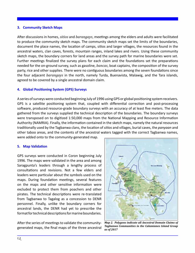
4. Global Positioning System (GPS) Surveys
A series of surveys were conducted beginning July of 1996 using GPS or global positioning system receivers. GPS is a satellite positioning system that, coupled with differential correction and post-processing software, produced resource-grade boundary surveys with an accuracy of at least five meters. The data gathered from the surveys supplied the technical description of the boundaries. The boundary surveys were transposed on to digitized 1:50,000 maps from the National Mapping and Resource Information Authority (NAMRIA). Finally, the information contained in the sketch maps, namely the natural resources traditionally used by the Tagbanwa clans, the location of sitios and villages, burial caves, the panyaan and other taboo areas, and the contents of the ancestral waters tagged with the correct Tagbanwa names, were added onto to the community-generated map.
5. Map Validation
GPS surveys were conducted in Coron beginning July 1996. The maps were validated in the area and among Saragpunta’s leaders through a lengthy process of consultations and revisions. Not a few elders and leaders were particular about the symbols used on the maps. During foundation meetings, several features on the maps and other sensitive information were excluded to protect them from poachers and other pirates. The technical descriptions were re-translated from Tagbanwa to Tagalog as a concession to DENR personnel. Finally, unlike the boundary corners for ancestral lands, the DENR had yet to prescribe the format for technical descriptions for marine boundaries.
After the series of meetings to validate the community-generated maps, the final maps of the three ancestral
Map 2. Polygons indicate all Ancestral Domain Claims of Tagbanwa Communities in the Calamianes Island Group as of 2017
12
13
domain claims covering Coron Island, Barangay Bulalacao and the northern region of Turda, Buenavista, Malawig and the Tara islands, were endorsed to the Palawan Provincial Special Task Force on Ancestral Domains (PSTFAD), a multi-sectoral task force charged with processing, reviewing and validating ancestral domain claims.
6. Advocacy to PCSD, CENRO, PSTFAD, and the DENR
The maps became important tools to introduce, locate, explain and convince government authorities and policy makers of the vital importance of the ancestral waters to the continued survival of Calamian Tagbanwa communities. The maps and their technical description were validated by the PSTFAD and were presented to the PCSD and the Coron Municipal Council. The maps and other basic documents of the CADC application were forwarded to the Regional Office for Region 4B, and consequently endorsed to the Office of the DENR Secretary. In all the hearings where the maps and other documents were presented, not a single opposition disputed the veracity of the evidence, that is, the historical accounts, place names, and the claim of the Calamian Tagbanwa that their communities have been occupying and using their homelands since time immemorial, was accepted without opposition.
In response to the Saragpunta’s application, the Coron Sangguniang Bayan filed more than 14 municipal resolutions opposing the ancestral domain claim. The council cited the interest of the burgeoning tourism industry, large-scale commercial fishing, as well as the entry of the European Union (EU)-funded conservation program for the Integrated Protected Areas. The municipal council, however did not dispute the evidence that the Calamian Tagbanwa, have held time immemorial possession, occupation and utilization over these areas.
Addressing the counter-claims filed to reduce the Coron Island application, then Undersecretary Antonio La Viña used the maps as bases for his decision to recommend the recognition of the Coron Island CADC, stating:
“… After carefully sifting through all the evidence presented by TFCI in support of their claim, we find that they have not only established their time immemorial possession over the two islands being claimed, but also over the waters indicated in their community map.
First, the claimant-group of indigenous peoples have been dependent heavily on their surrounding waters for the source of their livelihood, as the majority of them are traditional fisherfolk by profession. They still use the traditional methods of subsistence fishing using raditional tools, the practice of which dates back since time immemorial …
The boundaries of their ancestral waters were not arbitrarily chosen, but were identified by reefs and were premised on their indispensable role in maintaining their indigenous concept of ecological balance … Lastly, they have also designated areas open to small scale and traditional fishing. The subject, Tagbanwa group, considers each particular area as being intertwined with each other, and as a whole, forms part of their ancestral domain.
Given the foregoing premises, it is our opinion that the claimant Tagbanwas have sufficiently established that they have been using the two islands and the waters between and around them, as indicated in their community sketch map, since time immemorial, the same areas are part of their ancestral domain … “
Outcome of the Initiative
On 12 June 1998, the Tagbanwa struggle for recognition of their Ancestral Domain (land and water) finally came into fruition. The CADC of Coron island consisting of 22,400 hectares of land and waters was signed and approved by then DENR Secretary Victor O. Ramos after an exhaustive review of the claim.
In 2002, five years after the enactment of IPRA, the National Commission on Indigenous Peoples (NCIP) converted the Tagbanwa’s CADC into a Certificate of Ancestral Domain Title (CADT), a legal title formally recognizing the rights of possession of IPs over their ancestral domains identified and delineated in accordance with the rules of the IPRA. Upon further review of the claim, in 2002 the NCIP promulgated Administrative Order 1, series of 2002 that determined with finality the validity of the CADT. After the review and revalidation, the total area of the CADT increased by 2,236 hectares from their previous coverage of the Tagbanwa’s claim.
The approval and issuance of the Coron CADT served as a precedent for the recognition of two other CADT claims in Northern Palawan, which included substantial parts of the ocean and aquatic resources. In 2008, the CADT application of the Tagbanwa of Calauit Island covering 55,539.1057 hectares (93 percent or 51,855 as ancestral waters), was approved and was later awarded in March 2010. The CADT of the Tagbanwa communities in barangays Tara, Malawig and Buenavista covering at least 75,639.39 hectares was also approved in 2010, but has not been awarded as of this writing.
Issues and Analysis
Overlapping Tenure
The approval of the Tagbanwa CADT and its consequent issuance is a huge victory for the community, however policy overlaps threaten to undermine its value and deny the Tagbanwa the opportunity to enjoy the bundle of rights that the CADT provides. While there are also policy conflicts regarding the disposition and ownership of the terrestrial portion of the ancestral domain, these pale in comparison to the jurisdictional discord and policy incoherence that arise on the inclusion of parts of the ocean in the CADT and its conversion into private property.
The coverage of municipal waters as defined by the Local Government Code and the Fisheries Code7 is in direct conflict with the IPRA. Furthermore, existing laws of the country do not vest private ownership to any body of water, which are considered a part of the Public
14
15
Domain in perpetuity
The ancestral waters of the Tagbanwa in Coron physically overlaps with the municipal waters of the LGU of Coron. Hence, issues and conflict in jurisdiction as well as authority to zone the ancestral waters vis-à-vis the municipal waters and regulate activities arise. For instance, the Local Government Code provides the mandate to the LGU to regulate activities in the municipal waters and enforce fishery laws.8 On the other hand, RA 8371 (IPRA) empowers the Indigenous Community to formulate an Ancestral Domain Sustainable Development and Protection Plan (ADSDPP). In the ADSDPP, they can assert the right to control, manage, develop, protect, conserve, and sustainably use: a) land, air, water and minerals; b) plants, animals and other organisms; c) collecting, fishing and hunting grounds; d) sacred sites; and, e) other areas of economic, ceremonial and aesthetic value in accordance with their indigenous knowledge systems and practices (IKSPs) and customary laws and traditions.9
Issues on Resource Use and Governance
The Local Government Code and the Fisheries Code10 gives the LGU the authority to issue resource-use permits and collect fees and other levies. The Fisheries Code also calls for the creation of local multi-sectoral fishery councils called Fisheries and Aquatic Resources Management Councils (FARMCs), which shall act as a consultative body to the LGU in the determination of fees and licenses, as well as partners in the enforcement of laws. Demarcated areas may also be set aside by the LGU for the use of fisherfolk organizations or their Fishery Cooperatives. This mandate directly goes against the IPRA where ICCs/IPs have been vested with rights of ownership over lands, waters (both inland and offshore), and natural resources and all improvements made by them at any time within the ancestral domains/lands. These rights shall include, but not limited to, the right over the fruits, the right to possess, the right to use, right to consume, right to exclude and right to recover ownership.11
Overall, the Fisheries Code of 1998 is an expression of a more traditional, bygone view of resource exploitation, that is, it envisions the development of the fisheries and aquatic resources sector as an industry through a system of permits, licenses and tax breaks as incentives. The Code takes tentative steps in the protection of marine resources, as far as it adopts provisions from existing environmental laws to feature ecological concepts and environmental conservation. It is very clear in penalizing the clearing of mangroves to make way for fish pens. Yet, the Code is virtually silent on ancestral waters, the role of indigenous peoples in the governance of aquatic areas and the recognition and protection of the rights of indigenous fisherfolk.
The FARMC while it allows local participation in the management of aquatic resources, remains a consultative body to the LGU (which shall issue permits and collect fees), and is clearly not a governing management board. The Code vaguely allows for a “private sector” representative for the National Fisheries and Aquatic Resources Management Council (NFARMC) separate from fisherfolk organizations, which is an unusual view given that small fisherfolk are part of the private sector. Moreover, it does not provide ample room to accommodate the peculiar needs and conditions of indigenous peoples who assert claims of ownership over the coastal and aquatic areas, but merely lumps them together with other small-fisher folks.
It would be difficult to ascertain if indigenous communities would find the permit system through the Department of Agriculture (DA) and the LGU appropriate or even sensitive to indigenous legal systems, and indigenous concepts of ownership and resource use. The Revised Fisheries Code was enacted without undergoing a process of consultation among the indigenous fisherfolk communities, and this has had a telling effect on the law’s present form: it is virtually silent on the rights of indigenous communities over ancestral waters and prior rights over traditional fishing grounds.
While the Fisheries Code highlights the regulation of economic access to the 15-kilometer zone of coastal waters, indigenous communities may stress other non-economic issues, such as self-delineation of traditional territories, cultural artifacts and conflicting cultural values over aquatic resources. The latter may be cause for reservations in participating in FARMCs, apart from significant concerns over cultural integrity and traditional lifeways.
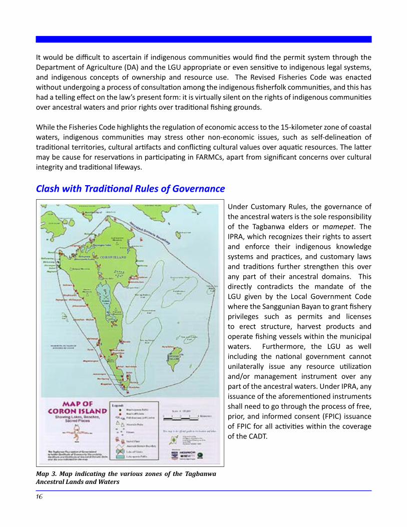
Clash with Traditional Rules of Governance
Under Customary Rules, the governance of the ancestral waters is the sole responsibility of the Tagbanwa elders or mamepet. The IPRA, which recognizes their rights to assert and enforce their indigenous knowledge systems and practices, and customary laws and traditions further strengthen this over any part of their ancestral domains. This directly contradicts the mandate of the LGU given by the Local Government Code where the Sanggunian Bayan to grant fishery privileges such as permits and licenses to erect structure, harvest products and operate fishing vessels within the municipal waters. Furthermore, the LGU as well including the national government cannot unilaterally issue any resource utilization and/or management instrument over any part of the ancestral waters. Under IPRA, any issuance of the aforementioned instruments shall need to go through the process of free, prior, and informed consent (FPIC) issuance of FPIC for all activities within the coverage of the CADT.
Map 3. Map indicating the various zones of the Tagbanwa Ancestral Lands and Waters
16
17
Governance of the Coastal and Aquatic Areas
The Tagbanwa Foundation of Coron Island has formulated their ADSDPP. The Plan defines the various zones of the Domain and provides the corresponding details of the governance policies of each zone. These include no-go zones, fish sanctuaries, tourism areas, sacred sites and fish harvesting rules and regulations.12 However, the harmonization with the local Comprehensive Land Use Plan (CLUP) and the adoption of the Tagbanwa ADSDPP has been very difficult and challenging. The Tagbanwa see a very rough road ahead in their effort to secure LGU recognition of their ADSDPP. The issues arising from the policy overlaps of the Fishery Code, Local Government Code and the Indigenous Peoples Rights Act regarding the governance of the aquatic areas, which fall under the same jurisdictions, have been very difficult to resolve.
The SEP Law, The Fisheries Code and Ancestral Waters
The Strategic Environment Plan of Palawan takes a more conciliatory stance with regards to the recognition of indigenous rights of over the ocean. The SEP identifies “tribal ancestral lands” as one of three main components of the ECAN13 and defines “tribal ancestral lands” in Section 3 as “… areas comprising both land and sea that are traditionally occupied by the cultural minorities. It goes further by defining the ECAN areas: “These areas, traditionally occupied by cultural minorities, comprise both land and sea areas. These shall be treated in the same graded system of control and prohibition as in the others abovementioned except for stronger emphasis in cultural considerations. The SEP, therefore, shall define a special kind of zonation to fulfill the material and cultural needs of the tribes using consultative processes and cultural mapping of the ancestral lands.” The provisions of the SEP law (RA 7611) on the definition of ECAN areas were pioneering. It was the first Republic Act that acknowledged the existence of ancestral waters within ancestral domains. This was not lost among the Tagbanwa of Coron as they extensively quoted the SEP provisions on ECAN zoning to provide a legal backbone for their claim of ancestral waters as part of their ancestral domain.
Finally, in the case of Palawan, the Fisheries Code differs from the SEP’s definition of coastal areas. The Revised Fisheries Code specifies coastal areas or coastal zones as a band of dry and submerged land at the direct interface of earth and ocean processes, which may include areas within 1 kilometer from the shore at high tide. As mentioned above, the SEP defines a coastal zone as an area, which includes the whole coastline up to the open sea. Apart from a coastal core zone, this may also include communal fishing grounds. The SEP also stipulates that “Tribal Ancestral Lands” may comprise both land and sea areas whose control and prohibition will place a stronger emphasis on “cultural considerations,” employing “cultural mapping” in devising a zoning scheme.
In providing for the Palawan Council for Sustainable Development, which adopts the SEP as its core strategy, the Revised Fisheries Code clearly gives way to these issues. In a provision, the Code adopts the PCSD’s special mandate to grant permits within the 15-kilometer zone of coastal waters. It can be argued from this provision that guidelines covering the PCSD’s zoning scheme also applies to the 15-kilometer zone of coastal waters; and thus, at least in the case of the Tagbanwa CADT, “cultural considerations” and the “material and cultural needs” of indigenous communities will take precedence in the delineation of Teeb ang Surublien.
Conclusions1. The Tagbanwa initiative to secure their ancestral domains has put the Philippines on the world
map, being the first “Ancestral Waters Claim” recognized by a Government. Its impact locally is just starting to be felt in various fields. Internationally, the Tagbanwa claim is seen as an inspiration to the indigenous communities in the Philippines including those from neighboring countries such as the indigenous peoples of Maluku in Indonesia and the aborigines of Torres Straits in Australia. Representative from these groups have gotten in touch with the Tagbanwa and have asked for information regarding the details of the ancestral domain claim.14
As soon as Government formally recognized the Coron Island claim, many indigenous communities went through the process of filing a claim for their ancestral land and waters. These include the Agta of Aurora Province, the Aeta of Bataan and the Ivatan of Batanes. All of these three CADT applications have since been approved and titles that cover a substantial portion of the oceans have been issued.
2. The approval of the Coron Island claim signals Government’s slow acceptance and understanding of the indigenous peoples traditional rights over the country’s natural resources and the positive role that indigenous peoples play in the protection and conservation of the nation’s aquatic resources. More importantly, the Coron lsland claim has a more significant value as it lies in the heart of Tagbanwa culture. As mentioned earlier the Island is seen as the central locus of activities and initiative both past and current. Thus the approval of the Coron CADT will have strong ramifications in the current and future management of the natural resources in the Calamianes group of islands.
3. The impact of the Coron claim shall also be seen on the way how Government will craft and implement administrative policies, including the rules and regulations regarding coastal resource management in areas where there are indigenous communities. Its effects on legal jurisprudence has yet to be seen although there is talk that certain affected quarters are mulling on the idea of challenging the CADT in court due to its policy overlaps with the Local Government Code and the Fisheries Code.
4. The success of Coron claim has given substance to the definition of “ancestral waters” as embodied in the new IPRA. The framers of the Law have had difficulty in concretely explaining the parameters of “ancestral waters,” as there were no existing models of such a claim. The Coron claim has provided a concrete example and a precedent for such a claim; not only on what it has resulted into but even to the extent of the process on how it was started and undertaken.
5. The existence of a positive legal and policy environment facilitated the necessary conditions for the Tagbanwa to secure the recognition of their ancestral domain. Department Administrative Order No. 02 of the DENR, the provisions on the recognition of Tribal Zones of the SEP law (RA 7611) and ultimately RA 8371 or IPRA provided the necessary legal backbone for the inclusion of ‘ancestral waters’ in the CADT claim of the Tagbanwa of Coron. However, these laws and policies still depended on the informed, if not sympathetic, interpretation of champions and progressive allies within Government who were in power at that particular time. Other national laws and policies on aquatic resources still pose a formidable challenge to realizing the full potential of the Tagbanwa ancestral waters claim.
18
19
6. Unresolved policy conflicts of the IPRA with the Local Government Code and the Fisheries Code of the Philippines will continue to undermine implementation of the progressive of the above-mentioned laws. Potential benefits that can be derived from the aforementioned laws by poor fisherfolk and the indigenous peoples cannot be secured unless contradicting provisions on coverage, mandate and jusrisdiction are resolved. Moreover, overlaps in jurisdiction can become flashpoints that may lead to bigger conflicts not only within Government but among the fiusherfolk and Indigenous peoples sector who are competing for access to a very scarce resource.
Recommendations1. The Tagbanwa participants in their report articulate
that environmental degradation brought about by the practice of illegal fishing methods continue and the the unabated expansion of the toursim industry still threaten their livelihoods and tenurial security over their acestral domains. While, the three CADTs have brough relief to some Tagbanwa communities, other groups who have yet to get their titles continuously face problems that threaten their livelihoods and survival.
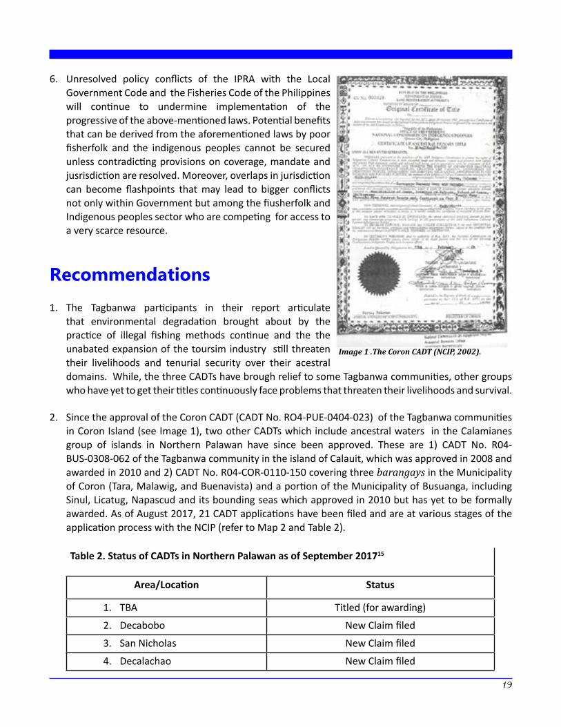
2. Since the approval of the Coron CADT (CADT No. RO4-PUE-0404-023) of the Tagbanwa communities in Coron Island (see Image 1), two other CADTs which include ancestral waters in the Calamianes group of islands in Northern Palawan have since been approved. These are 1) CADT No. R04-BUS-0308-062 of the Tagbanwa community in the island of Calauit, which was approved in 2008 and awarded in 2010 and 2) CADT No. R04-COR-0110-150 covering three barangays in the Municipality of Coron (Tara, Malawig, and Buenavista) and a portion of the Municipality of Busuanga, including Sinul, Licatug, Napascud and its bounding seas which approved in 2010 but has yet to be formally awarded. As of August 2017, 21 CADT applications have been filed and are at various stages of the application process with the NCIP (refer to Map 2 and Table 2).
Table 2. Status of CADTs in Northern Palawan as of September 201715
Area/Location Status
1. TBA Titled (for awarding)
2. Decabobo New Claim filed
3. San Nicholas New Claim filed
4. Decalachao New Claim filed
Image 1 .The Coron CADT (NCIP, 2002).
5. San Jose New Claim filed
6. Lakdayan/Cheey New Claim filed
7. Marcilla Filed
8. Borac Filed
9. Decarabao New Claim filed
10. Chindunam/Tangguyod New Claim filed
11. Galoc New Claim filed
12. Berg New Claim filed
13. Alulad New Claim filed
14. Manily New Claim filed
15. Marabal New Claim filed
16. Bigon New Claim filed
17. Depelenged New Claim filed
18. Sagrada New Claim filed
19. New Busuanga New Claim filed
20. PASICMIDA For Final Reading
21. Turda For Final reading
22. Coron Island Titled
23. NRCQ/BCM Titled
24. Bulalacao On Process
25. Lajala On Process
26. Balisungan On Process
3. While the number of CADT claims, which includes ancestral waters in Northern Palawan, has increased, there has been no commensurate effort to facilitate local dialogue among the various stakeholders (LGU, ICCs, fisherfolk, private sector, etc.). The need to undertake formal discussions and dialogue among the various stakeholders of the aquatic resources in Northern Palawan is very urgent.
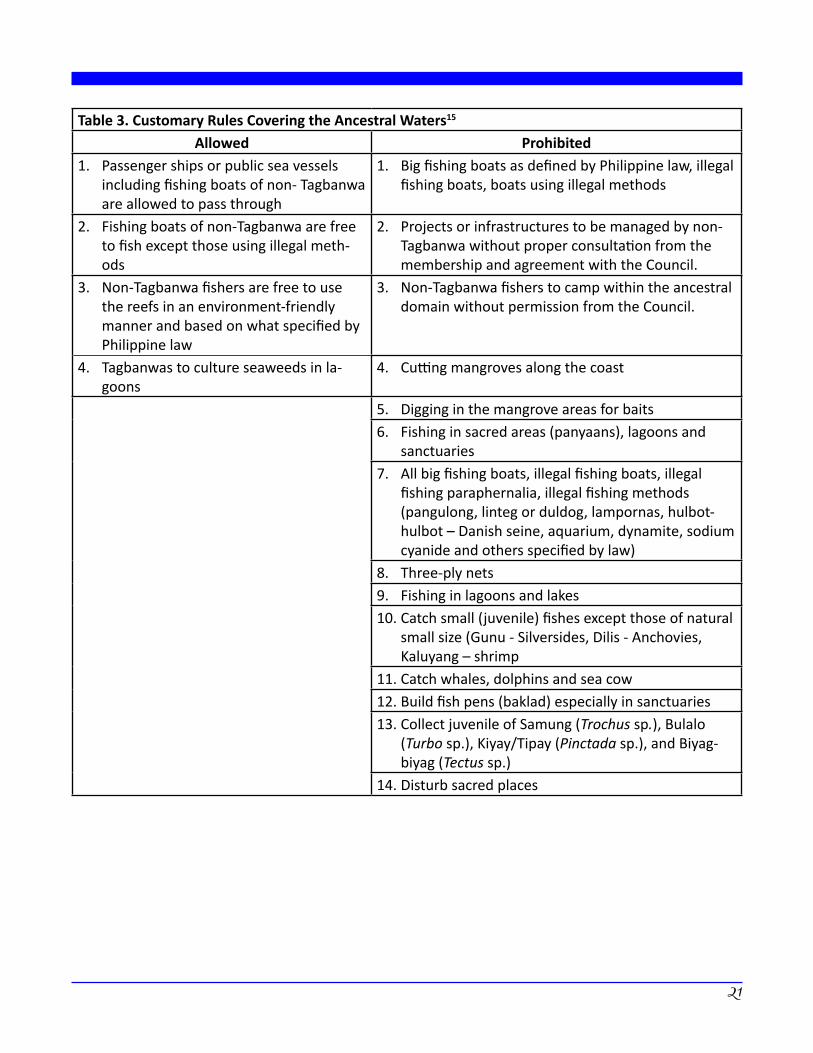
4. The level of understanding and appreciation of the nature of the “Teeb and Surublien” or ancestral waters with the greater public and among the stakeholders in Northern Palawan is still very limited. This has led to many false and negative perceptions that further create enmity against the Tagbanwa communities. For instance, many perceive that areas of the ocean that fall within ancestral waters will no longer be accessible to the public and will be exclusively for the Tagbanwa. Unfortunately, the positive values of traditional resource management of the ocean as well as the inclusive nature and concepts of resource stewardship of the Tagbanwa have not been properly explained to the public (see Table 3).
20
21
Table 3. Customary Rules Covering the Ancestral Waters15
Allowed Prohibited 1. Passenger ships or public sea vessels
including fishing boats of non- Tagbanwa are allowed to pass through
1. Big fishing boats as defined by Philippine law, illegal fishing boats, boats using illegal methods
2. Fishing boats of non-Tagbanwa are free to fish except those using illegal meth-ods
2. Projects or infrastructures to be managed by non-Tagbanwa without proper consultation from the membership and agreement with the Council.
3. Non-Tagbanwa fishers are free to use the reefs in an environment-friendly manner and based on what specified by Philippine law
3. Non-Tagbanwa fishers to camp within the ancestral domain without permission from the Council.
4. Tagbanwas to culture seaweeds in la-goons
4. Cutting mangroves along the coast
5. Digging in the mangrove areas for baits6. Fishing in sacred areas (panyaans), lagoons and
sanctuaries7. All big fishing boats, illegal fishing boats, illegal
fishing paraphernalia, illegal fishing methods (pangulong, linteg or duldog, lampornas, hulbot-hulbot – Danish seine, aquarium, dynamite, sodium cyanide and others specified by law)
8. Three-ply nets9. Fishing in lagoons and lakes10. Catch small (juvenile) fishes except those of natural
small size (Gunu - Silversides, Dilis - Anchovies, Kaluyang – shrimp
11. Catch whales, dolphins and sea cow12. Build fish pens (baklad) especially in sanctuaries13. Collect juvenile of Samung (Trochus sp.), Bulalo
(Turbo sp.), Kiyay/Tipay (Pinctada sp.), and Biyag-biyag (Tectus sp.)
14. Disturb sacred places
15. Ancestral water is the main and has the largest contribution to the livelihood of the Tagbanwa. Whatever abuse is prohibited.
16. Non-Tagbanwas to claim and abuse any part of ancestral water
17. Non-Tagbanwas to use any portion of sanctuaries, lagoons, tide flats, sacred places
18. Illegal fishing by Tagbanwas and non- Tagbanwas19. Fishing in sanctuaries and lagoons by Tagbanwas
and non-Tagbanwas20. Drop anchors on coral reefs within the sanctuaries.
Motorized boats to enter sanctuaries21. Non-Tagbanwas to culture seaweeds in sanctuaries
without permission from the Council22. Anyone except for the owner to take cultured
seaweeds23. Culture seaweeds along canal-passage ways of
boats
5. A greater effort to document the Tagbanwa stewardship of their ancestral waters and the dissemination of information to the various stakeholders and the greater public is recommended by the Tagbanwa elders. This will afford them the opportunity to properly articulate their aspirations and expound on their conservation objectives and inclusive resource utilization rules over their ancestral waters.
6. There is a very strong clamor of the Tagbanwa from Coron Island to have their ancestral domain declared as a “World Heritage Site” under the UNESCO. They see the potential declaration and recognition as a World Heritage site as an additional layer of protection of their rights to exercise traditional governance and ownership of the Island. The Tagbanwa of Coron Island have been in touch with the local UNESCO Secretariat and have been informed on the processes of nomination as a potential World Heritage Site.
7. It was recommended that representations be made with NAMRIA to inform them of the existence of “ancestral waters” as a specific land use. It is hoped that this will encourage the NAMRIA to include the extents of “ancestral waters” of IPs not only in Northern Palawan but also those in other areas in the Philippines in their official bathyspheric maps as well as in the delineation of municipal waters.
8. It was recommended by the Tagbanwa for the Philippine Government to fully abide with its commitments in international treaties, agreements, guidelines and declarations that are in support of indigenous peoples’ rights such as the United Nations Declaration on the Rights of Indigenous Peoples (UNDRIP), VGGT, VGSSF and others that are supportive of indigenous peoples.n
22
23
Endnotes1 De Vera, D. and Zingapan, K. (2017). The Ancestral Lands and Waters of the Indigenous Tagbanwa Communities
of Northern Palawan. Quezon City: Asian NGO Coalition for Agrarian Reform and Rural Development (ANGOC).2 This case study was validated and finalized based on discussions during the multi-stakeholder provincial
consultation held in Coron, Palawan on 11 August 2017. Inputs for preparing the draft were generated during a workshop with indigenous community leaders conducted in Coron, Palawan on 10 August 2017.
3 The views presented in this document do not necessarily reflect those of FAO.4 These laws are further discussed in the Scoping Paper on the VGSSF and Philippine Policies and Laws on Fisheries.5 In Sec. 8, the other two components are (a) terrestrial and (b) coastal/marine, which “… includes the whole
coastline up to the open sea …” characterized by “... active fisheries and tourism activities.”6 Timothy Wright’s writing on Calamian Field Station in 1975 observed that the “... Calamines or “northern”
Tagbanwa follow a seminomadic, ocean fishing lifeway very different from that of the Tagbanwa of the mainland.”
7 RA 7160, Sec. 131, letter r states that “municipal waters” includes not only streams, lakes, and tidal waters within the municipality, not being the subject of private ownership and not comprised within the national parks, public forest, timber lands, forest reserves or fishery reserves, but also marine waters included between two lines drawn perpendicularly to the general coastline from points where the boundary lines of the municipality or city touch the sea at low tide and a third line parallel with the general coastline and 15 kilometers from it. Where two (2) municipalities are so situated on the opposite shores that there is less than 15 kilometers of marine waters between them, the third line shall be equally distant from opposite shores of their respective municipalities.
8 RA 7160 Chapter 2, Sec. 17, letter b, no. 29 RA 8371 Rule III, Part II, Sec. 210 RA 7160, Art. III, Sec. 149, letter a.11 RA 8371, Part II, Sec. I12 ADSDPP TFCI, 200413 In Sec. 8 the other 2 components are a) terrestrial and b) coastal/marine, which “ … includes the whole
coastline up to the open sea … ” characterized by “ .. active fisheries and tourism activities.”14 Correspondence with Dave de Vera, 2001.15 Reported by the Tagbanwa in the FAO-VGSSF Consultation, 2017.16 Source TFCI Adopted from Sampang, Arlene, G. The Calamian Tagbanwa Ancestral Domain (Coron Island,
Palawan, Philippines): Evaluation of traditional fishing practices towards biodiversity conservation and sustainability. Validated and updated during the VGSSF Provincial Consultation Workshop, Darayonan, Coron, August 2017.
Voluntary Guidelines for Securing Sustainable Small-Scale Fisheries in the Context of Food
Security and Poverty Eradication (VGSSF)
The Voluntary Guidelines for Securing Sustainable Small-Scale Fisheries in the Context of Food Security and Poverty Eradication (VGSSF) represent the first international instrument dedicated to the immensely important but often neglected sector – small scale fisheries sector. These guidelines have been developed in support to the overall principles and provisions of the 1995 FAO Code of Conduct for Responsible Fisheries (the Code). The development of the VGSSF was initiated in 2008 during the First Global Conference on Small-Scale Fisheries in Bangkok, Thailand and it was finally endorsed at the 31st Session of Committee of Fisheries (COFI) in June 2014.
The VGSSF complement other international instruments such as Voluntary Guidelines on the Right to Food, as well as Voluntary Guidelines on Responsible Governance of Tenure of Land, Fisheries and Forests.
The VGSSF have 98 provisions, covering 11 topics encompassing 3 major themes: (i) Introduction; (ii) Responsible Fisheries and Sustainable Development; and (iii) Ensuring an Enabling Environment and Supporting Implementation.
Part 1, Introduction, specifies the objectives, the nature and scope, the guiding principles by which the VGSSF are to be implemented as well as their relationship with other international instruments.
Part 2, Responsible Fisheries and Sustainable Development, provides guidance for fisheries-specific topics such as responsible governance of tenure and sustainable resource management, but also for crucial inter-sectoral issues: social development, employment and decent work; value chain, post-harvest and trade; gender equality; and disaster risks and climate change.
Part 3, Ensuring an Enabling Environment and Supporting Implementation, provides guidance on how to realize the principles and recommendations of the VGSSF through policy coherence, institutional and supporting implementation; information, research and communication; capacity development; and implementation support and monitoring.
This paper highlights the significance of securing tenure over ancestral waters for indigenous peoples. It narrates the initiative of the Calamian Tagbanwa tribe of Northern Palawan to map their ancestral domain to secure their tenure and assert their resource rights. It also identifies challenges presently faced by the Calamian Tagbanwa in managing their ancestral waters, including governance complications brought about by overlapping provisions in the Fisheries Code and the Indigenous Peoples’ Rights Act.
The Ancestral Lands and Waters of the Indigenous Tagbanwa Communities of Northern Palawan was prepared by PAFID for the project “Mainstreaming Voluntary Guidelines on Governance of Tenure,” implemented by ANGOC and supported by the Food and Agriculture Organization (FAO) of the United Nations. PAFID and ANGOC express our thanks to members of various indigenous communities, local government units and line agencies that contributed to the preparation of this study.
The views and information provided in this document do not necessarily reflect the views and policies of FAO.