
Ruide RTS 820
2
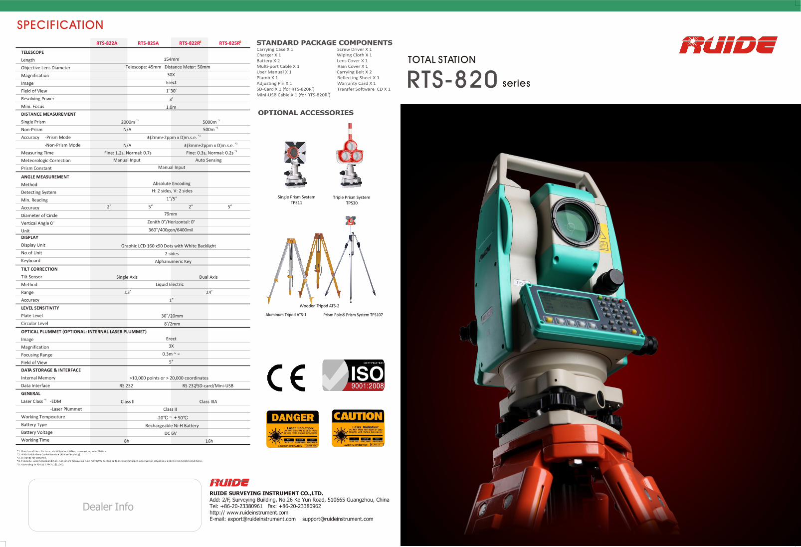
RUIDE SURVEYING INSTRUMENT CO.,LTD. Add: 2/F, Surveying Building, No.26 Ke Yun Road, 510665 Guangzhou, China Tel: +86-20-23380961 Fax: +86-20-23380962 http:// www.ruideinstrument.com E-mail: [email protected] [email protected] Dealer Info RTS-820 RTS-820 OPTIONAL ACCESSORIES STANDARD PACKAGE COMPONENTS Carrying Case X 1 Screw Driver X 1 Charger X 1 Wiping Cloth X 1 Battery X 2 Lens Cover X 1 Multi-port Cable X 1 Rain Cover X 1 User Manual X 1 Carrying Belt X 2 Plumb X 1 Reflecting Sheet X 1 Adjusting Pin X 1 Warranty Card X 1 5 SD-Card X 1 (for RTS-820R ) Transfer Software CD X 1 5 Mini-USB Cable X 1 (for RTS-820R ) Prism Pole Prism System TPS107 Single Prism System TPS11 Triple Prism System TPS30 Wooden Tripod ATS-2 Aluminum Tripod ATS-1 TOTAL STATION series SPECIFICATION *1 *1 2000m 5000m *2 N/A 500m *3 (2mm+2ppm x D)m.s.e. *3 N/A (3mm+2ppm x D)m.s.e. *4 Fine: 1.2s, Normal: 0.7s Fine: 0.3s, Normal: 0.2s Manual Input Auto Sensing Manual Input ANGLE MEASUREMENT Method Detecting System Min. Reading Accuracy Diameter of Circle Vertical Angle 0 Unit TILT CORRECTION Tilt Sensor Method Range Accuracy LEVEL SENSITIVITY Plate Level Circular Level OPTICAL PLUMMET (OPTIONAL: INTERNAL LASER PLUMMET) Image Magnification Focusing Range Field of View DATA STORAGE & INTERFACE Internal Memory Data Interface GENERAL *5 Laser Class -EDM -Laser Plummet Working Temperature Battery Type Battery Voltage Working Time DISPLAY Display Unit No.of Unit Keyboard DISTANCE MEASUREMENT Single Prism Non-Prism Accuracy -Prism Mode -Non-Prism Mode Measuring Time Meteorologic Correction Prism Constant Absolute Encoding H: 2 sides, V: 2 sides 1 /5 2 5 2 5 79mm Zenith 0 /Horizontal: 0 360 /400gon/6400mil TELESCOPE Length Objective Lens Diameter Magnification Image Field of View Resolving Power Mini. Focus 154mm Telescope: 45mm Distance Meter: 50mm 30X Erect 1 30 3 1.0m Graphic LCD 160 x90 Dots with White Backlight 2 sides Alphanumeric Key Erect 3X 0.3m ~ 5 30 /20mm 8 /2mm >10,000 points or > 20,000 coordinates RS 232 RS 232/SD-card/Mini-USB Class II Class IIIA Class II -20 ~ 50 Rechargeable Ni-H Battery DC 6V 8h 16h Single Axis Dual Axis Liquid Electric 3 4 1 *1. Good condition: No haze, visibilityabout 40km, overcast, no scintillation. *2. With Kodak Grey Cardwhite side (90% reflectivity). *3. D stands for distance. *4. *5. According to FDA21 CFRCh.1 .1040. Typically, under goodcondition, non-prism measuring time maydiffer according to measuring target, observation situations, and environmental conditions. RTS-822A RTS-825A RTS-822R RTS-825R 5 5
description
Especificaciones de la serie 820 de estación total Ruide (en ingles)
Transcript of Ruide RTS 820
RUIDE SURVEYING INSTRUMENT CO.,LTD.Add: 2/F, Surveying Building, No.26 Ke Yun Road, 510665 Guangzhou, ChinaTel: +86-20-23380961 Fax: +86-20-23380962 http:// www.ruideinstrument.comE-mail: [email protected] [email protected]
Dealer Info
RTS-820 RTS-820
OPTIONAL ACCESSORIES
STANDARD PACKAGE COMPONENTSCarrying Case X 1 Screw Driver X 1Charger X 1 Wiping Cloth X 1Battery X 2 Lens Cover X 1Multi-port Cable X 1 Rain Cover X 1User Manual X 1 Carrying Belt X 2Plumb X 1 Reflecting Sheet X 1Adjusting Pin X 1 Warranty Card X 1
5SD-Card X 1 (for RTS-820R ) Transfer Software CD X 1 5Mini-USB Cable X 1 (for RTS-820R )
Prism Pole Prism System TPS107
Single Prism System TPS11
Triple Prism System TPS30
Wooden Tripod ATS-2
Aluminum Tripod ATS-1
TOTAL STATION
series
SPECIFICATION
*1 *1 2000m 5000m
*2 N/A 500m
*3 (2mm+2ppm x D)m.s.e. *3 N/A (3mm+2ppm x D)m.s.e. *4
Fine: 1.2s, Normal: 0.7s Fine: 0.3s, Normal: 0.2s
Manual Input Auto Sensing
Manual Input
ANGLE MEASUREMENT
Method
Detecting System
Min. Reading
Accuracy
Diameter of Circle
Vertical Angle 0
Unit
TILT CORRECTION
Tilt Sensor
Method
Range
Accuracy
LEVEL SENSITIVITY
Plate Level
Circular Level
OPTICAL PLUMMET (OPTIONAL: INTERNAL LASER PLUMMET)
Image
Magnification
Focusing Range
Field of View
DATA STORAGE & INTERFACE
Internal Memory
Data Interface
GENERAL*5
Laser Class -EDM
-Laser Plummet
Working Temperature
Battery Type
Battery Voltage
Working Time
DISPLAY
Display Unit
No.of Unit
Keyboard
DISTANCE MEASUREMENT
Single Prism
Non-Prism
Accuracy -Prism Mode
-Non-Prism Mode
Measuring Time
Meteorologic Correction
Prism Constant
Absolute Encoding
H: 2 sides, V: 2 sides
1 /5
2 5 2 5
79mm
Zenith 0 /Horizontal: 0
360 /400gon/6400mil
TELESCOPE
Length
Objective Lens Diameter
Magnification
Image
Field of View
Resolving Power
Mini. Focus
154mm
Telescope: 45mm Distance Meter: 50mm
30X
Erect
1 30
3
1.0m
Graphic LCD 160 x90 Dots with White Backlight
2 sides
Alphanumeric Key
Erect
3X
0.3m ~
5
30 /20mm
8 /2mm
>10,000 points or > 20,000 coordinates
RS 232 RS 232/SD-card/Mini-USB
Class II Class IIIA
Class II
-20 ~ 50
Rechargeable Ni-H Battery
DC 6V
8h 16h
Single Axis Dual Axis
Liquid Electric
3 4
1
*1. Good condition: No haze, visibility about 40km, overcast, no scintillation. *2. With Kodak Grey Card white side (90% reflectivity).*3. D stands for distance.*4.
*5. According to FDA21 CFR Ch.1 .1040.
Typically, under good condition, non-prism measuring time may differ according to measuring target, observation situations, and environmental conditions.
RTS-822A RTS-825A RTS-822R RTS-825R5 5
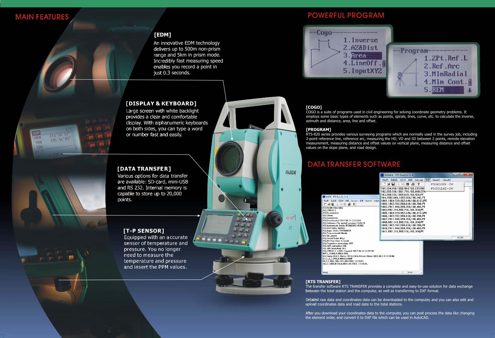
Large screen with white backlight provides a clear and comfortable display. With alphanumeric keyboards on both sides, you can type a word or number fast and easily.
An innovative EDM technology delivers up to 500m non-prism range and 5km in prism mode. Incredibly fast measuring speed enables you record a point in just 0.3 seconds.
[COGO]COGO is a suite of programs used in civil engineering for solving coordinate geometry problems. It employs some basic types of elements such as points, spirals, lines, curve, etc. to calculate the inverse, azimuth and distance, area, line and offset.
[PROGRAM]RTS-820 series provides various surveying programs which are normally used in the survey job, including 2-point reference line, reference arc, measuring the HD, VD and SD between 2 points, remote elevation measurement, measuring distance and offset values on vertical plane, measuring distance and offset values on the slope plane, and road design.
[DISPLAY & KEYBOARD]
Various options for data transfer are available: SD-card, mini-USB and RS 232. Internal memory is capable to store up to 20,000 points.
[DATA TRANSFER]
Equipped with an accurate sensor of temperature and pressure. You no longer need to measure the temperature and pressure and insert the PPM values.
[RTS TRANSFER]The transfer software RTS TRANSFER provides a complete and easy-to-use solution for data exchange between the total station and the computer, as well as transferring to DXF format.
Detailed raw data and coordinates data can be downloaded to the computer, and you can also edit and upload coordinates data and road data to the total stations.
After you download your coordinates data to the computer, you can post process the data like changing the element order, and convert it to DXF file which can be used in AutoCAD.
POWERFUL PROGRAM
DATA TRANSFER SOFTWARE
MAIN FEATURES
[EDM]
[T-P SENSOR]