Red de Parques Nacionales de España
36
-
Upload
fernando-garcia -
Category
Documents
-
view
19 -
download
2
description
Actualización Febrero 2015
Transcript of Red de Parques Nacionales de España
La Red de Parques Nacionales, más que una suma de parques
Desde que en los primeros años del pasado siglo XX, se declararon los dos primeros parques nacionales españoles, la Montaña de Covadonga, actualmente Picos de Europa, y Ordesa, estos privilegiados espacios, muestrario excepcional de nuestros sistemas naturales, permanecen como testigos de los enormes cambios sociales, económicos, políticos… y naturales habidos en este tiempo.
Los 15 parques nacionales son muy distintos entre sí. Unos son muy grandes y otros no, unos son de montaña, otros muestran bosques de todo tipo, los hay que albergan importantes humedales extensos o reducidos, otros son casi solo impresionantes campos de lava o edificios volcánicos, otros reúnen el mar y la tierra en espectaculares archipiélagos… todos son especiales y cada uno posee una personalidad diferenciada.
Su relación con los humanos, que por otro lado formamos parte esencial de ellos, nunca ha sido fácil del todo. Los parques nacionales entrañan en sí mismos una paradoja: son espacios reservados para que los procesos naturales ocurran libremente y se asegure su conservación, pero a la vez tienen señalada la misión de recibir a aquellos que los quieran conocer y tocar, por supuesto no más de los que puedan aceptar.
De esta oposición, han surgido en estos casi cien años innumerables conflictos por el uso del agua, por la presencia de especies depredadoras, por el
aprovechamiento de otros recursos naturales; en el fondo, la dificultad que encontramos las personas en aceptar las limitaciones, por más justificadas que estén y por mucho que contribuyan al bien de todos. Por ello, desde hace muchos años se indemnizan las limitaciones que son reales y están legalmente acreditadas. Y por ello también se promueve una política de aumento de la propiedad pública en el conjunto de la Red.
Una media anual de visitantes a la Red de más de diez millones de personas en los últimos diez años y cerca de un millón y medio viviendo en sus áreas de influencia, dan fe de que existe una estrecha relación entre los parques nacionales españoles y la gente. Por ello se han tratado de aplicar las mejores prácticas de uso público conocidas para los visitantes, se han creado infraestructuras y centros de acogida y de información, se han formado guías, se intenta asegurar la accesibilidad para personas con discapacidad y se pone a nuestra disposición una central electrónica de reservas.
Para aquellos que no se conforman con una visita más o menos rápida y quieren ayudar, existe un programa de voluntariado que facilita compartir la vida diaria de los parques con sus gestores y responsables. Y para los que viven en el entorno de los parques, se ha desarrollado un programa de apoyo económico a las personas, empresas, ONG y ayuntamientos que necesiten mejorar sus servicios, especialmente los ambientales y turísticos. El hecho de residir en el entorno de un parque nacional no debe ser otra cosa que una ventaja, para todos aquellos que viven y han crecido cerca de ellos.
Como la Red de Parques Nacionales alberga un rico y variado patrimonio natural y resulta ser el escenario de una cuidadosa interacción secular con el hombre, constituye también un escenario muy adecuado para investigar, para aumentar nuestros conocimientos sobre los procesos ecológicos de siempre o sobre otros nuevos, como el cambio global. Y por ello, cada año se desarrollan en ellos diferentes proyectos que contribuyen a este fin.
También son muy adecuados nuestros parques nacionales para aplicar técnicas de seguimiento y evaluación que en otros entornos resultarían impensables. Como resulta esencial conocer de una manera continua en el tiempo su estado de conservación, el seguimiento también debe serlo y para garantizar esta continuidad, se apoya en la mutua colaboración entre los responsables de administrar la Red y cada uno de los parques.
El Organismo Autónomo Parques Nacionales, tiene la misión de atender al conjunto de la Red, por ello dedica sus esfuerzos a coordinar e impulsar las iniciativas encaminadas a su conservación y refuerzo como un todo, apoyando a los responsables de los distintos parques nacionales en su tarea de conservarlos y darlos a conocer a esta generación y a las futuras. El valor que la Red de Parques Nacionales aporta a nuestra sociedad, es superior al de la mera suma individual de cada uno de ellos, ya de por sí muy elevada.
Basilio Rada Martínez Director del Organismo Autónomo Parques Nacionales
Los parques nacionales, por ser de interés general de la Nación, se declaran mediante Ley de las Cortes Generales. Deben cumplir unos requisitos muy estrictos y por ello son poco numerosos. Su objetivo es la conservación, y la normativa que los sustenta y que todos debemos cumplir es muy exigente.
The National Parks Network: more than a mere set of parks
Since the early 20th century, when the Montaña de Covadonga (currently the Picos de Europa) and Ordesa were declared Spain’s first two national parks, privileged areas such as these, which are exceptional samples of our natural systems, still stand as witnesses to the huge social, economic, political... and natural changes that have come about in all this time.
The 15 national parks are all very different from each other. Some are very large, while others are not; some are mountainous and others sport woodland of all kinds; some contain major, sizeable or smaller-scale tracts of wetlands, and others are virtually only impressive fields of lava or volcanic structures, while others bring the sea and the land together in spectacular archipelagos… but all of them are special and each of them has its own distinctive personality.
Their relationship to human beings (on the other hand we are an essential part of them too) has never been altogether easy. The national parks hold a paradox within themselves: they are spaces set apart so that natural processes can take place there unhindered and efforts are made to ensure their conservation, yet at the same time their role has been marked out as one of playing host to those who wish to get to know them and come into contact with them, though obviously no more than they can manage with. Over what have been almost a hundred years now, this collision course has given rise to numerous conflicts over the use of water, the presence of predators, and the exploitation of other natural
resources: this actually boils down to the difficulty we people find in accepting limitations, however justified these might be and however much they might help towards the common good. This is why for some years now those limitations which are genuine and have been legally accredited to have been compensated for. And this also explains why policy is being promoted that tends towards increasing public property within the network as a whole.
On average more than ten million people a year have visited the network in the last ten years and around one and a half million people who live within its areas of influence can attest to the close relationship between the Spanish national parks and mankind. For this reason efforts have been made to apply knowledge of best practises regarding public use as visitors, embracing infrastructures that have been created, and reception and information centres, the training of qualified guides and initiatives to ensure accessibility for the disabled, while an electronic central booking office has been set up.
For those people not just content to enjoy either a brief or an extended visit and would like to lend a hand, there is a programme for volunteers which implies sharing in the daily life of the parks along with those managing them and responsible for them. And for those who live in the neighbourhood of the parks a financial support programme has been developed for people, companies, NGOs and local councils which need to improve the services they provide, particularly regarding the environment and tourism. Living within the surroundings of a national park should be nothing other than an advantage for everyone who lives and has grown up near them.
As the National Parks Network contains a rich and varied natural asset and has staged an age-old and carefully maintained interaction with man, it also represents a very suitable scene for carrying out research, building on our knowledge of the usual ecological processes or even some new ones, such as global climate change. For this reason many different projects are conducted in them every year to contribute toward this end.
Our national parks are also very appropriate for applying monitoring and evaluation techniques that would be unthinkable in other environments. As it is essential to keep an ongoing record of their state of conservation over time, tracking of this must also be constant and over time to guarantee the necessary continuity, and this relies on mutual cooperation between those in charge of managing the network and each of the parks.
The mission of the National Parks Autonomous Body is to look after the network as a whole and thus devotes its efforts to coordinating and promoting initiatives aimed at conserving it and strengthening it as a whole entity, and to provide support for those in charge of the various individual national parks in their duties of conserving them and publicising them for this and generations. The value which the National Parks Network provides for our society is greater than the mere sum of the individual parks, which is already very high in its own right.
Basilio Rada Martínez Director of the “Organismo Autónomo Parques Nacionales”
As they are of interest generally to the Nation, the national parks are declared as such via the General Spanish Parliament Act. They must meet certain very strict requirements, for which reason they are relatively few in number. The objective here is conservation and the legislation that underpins them and which we should all observe is highly demanding.
Throughout these pages we will visit the suit of fifteen National Parks forming the Network.
Exceptional and symbolic sites: unique displays of the natural wealth in our land that form a complex and representative system. With its outstanding biodiversity, unequalled in Europe, it is a paradigm of the conservation of natural areas.
They all shelter outstanding ecological and cultural values, the results of centuries of geological moulding and landscape formation, of the interaction between ecosystems, and they are fortunate witnesses to the harmonious integration of human activity with its natural environment.
These processes are necessary and beneficial, as they enable us to enjoy this magnificent natural heritage and have led to an awareness and appreciation of the wonders that nature provides.
The National Parks are veritable environmental works of art, works whose integrity should be conserved.
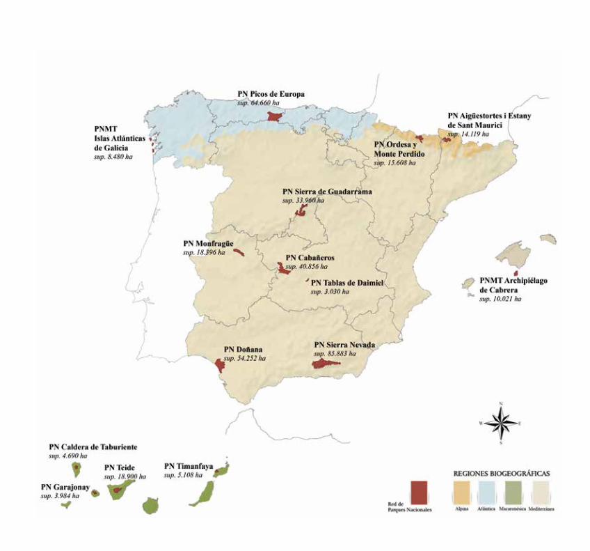
A lo largo de estas páginas recorreremos el conjunto de los quince parques nacionales que integran la Red.
Parajes excepcionales y simbólicos, escenarios únicos de la riqueza natural de nuestro territorio conforman un complejo sistema representativo y singular de la biodiversidad excepcional en España y Europa, paradigma de la conservación de espacios naturales.
Todos ellos albergan destacados valores ecológicos y culturales, resultado de siglos de modelado geológico y procesos de formación de paisajes, de interacción entre ecosistemas y son testigos privilegiados de una integración armónica entre la actividad humana y su entorno natural.
Estos procesos, necesarios y beneficiosos, que nos permiten disfrutar de una maravillosa herencia natural y nos han conducido a la concienciación y la valoración de las riquezas que la naturaleza nos ofrece.
Los parques nacionales son verdaderas obras de arte ambientales cuya integridad debemos conservar.
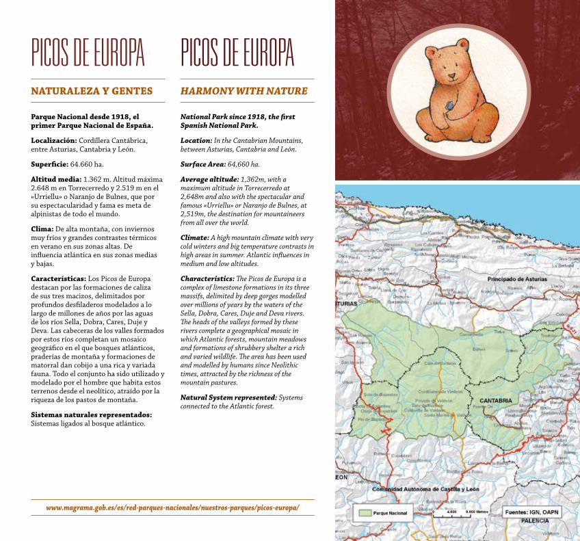
Picos de euroPaNatuRaLeza y GeNteS
Parque Nacional desde 1918, el primer Parque Nacional de españa.
Localización: Cordillera Cantábrica, entre Asturias, Cantabria y León.
Superficie: 64.660 ha.
altitud media: 1.362 m. Altitud máxima 2.648 m en Torrecerredo y 2.519 m en el «Urriellu» o Naranjo de Bulnes, que por su espectacularidad y fama es meta de alpinistas de todo el mundo.
Clima: De alta montaña, con inviernos muy fríos y grandes contrastes térmicos en verano en sus zonas altas. De influencia atlántica en sus zonas medias y bajas.
Características: Los Picos de Europa destacan por las formaciones de caliza de sus tres macizos, delimitados por profundos desfiladeros modelados a lo largo de millones de años por las aguas de los ríos Sella, Dobra, Cares, Duje y Deva. Las cabeceras de los valles formados por estos ríos completan un mosaico geográfico en el que bosques atlánticos, praderías de montaña y formaciones de matorral dan cobijo a una rica y variada fauna. Todo el conjunto ha sido utilizado y modelado por el hombre que habita estos terrenos desde el neolítico, atraído por la riqueza de los pastos de montaña.
Sistemas naturales representados: Sistemas ligados al bosque atlántico.
Picos de euroPahARMoNy with NAtuRe
National Park since 1918, the first Spanish National Park.
Location: In the Cantabrian Mountains, between Asturias, Cantabria and León.
Surface Area: 64,660 ha.
Average altitude: 1,362m, with a maximum altitude in Torrecerredo at 2,648m and also with the spectacular and famous «Urriellu» or Naranjo de Bulnes, at 2,519m, the destination for mountaineers from all over the world.
Climate: A high mountain climate with very cold winters and big temperature contrasts in high areas in summer. Atlantic influences in medium and low altitudes.
Characteristics: The Picos de Europa is a complex of limestone formations in its three massifs, delimited by deep gorges modelled over millions of years by the waters of the Sella, Dobra, Cares, Duje and Deva rivers. The heads of the valleys formed by these rivers complete a geographical mosaic in which Atlantic forests, mountain meadows and formations of shrubbery shelter a rich and varied wildlife. The area has been used and modelled by humans since Neolithic times, attracted by the richness of the mountain pastures.
Natural System represented: Systems connected to the Atlantic forest.
www.magrama.gob.es/es/red-parques-nacionales/nuestros-parques/picos-europa/
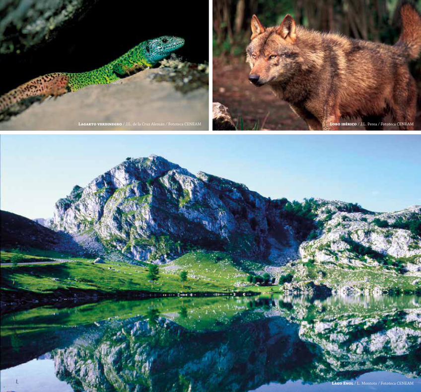
Lagarto verdinegro / J.L. de la Cruz Alemán / Fototeca CENEAM Lobo ibérico / J.L. Perea / Fototeca CENEAM
Lago enol / L. Montoto / Fototeca CENEAM
www.magrama.gob.es/es/red-parques-nacionales/nuestros-parques/ordesa/ www.rednaturaldearagon.com/default.aspx?FolderiD=86aragon.es/ordesa
ordesa y Monte PerdidoBaLCoNeS aL CieLo
Parque Nacional desde 1918.
Localización: En los Pirineos centrales, en el norte de Huesca.
Superficie: 15.608 ha de Parque Nacional y 19.679 ha de zona periférica de protección.
altitud media: 2.043 m. Máxima, 3.348 m (Monte Perdido). Mínima, 700 m (Fuente de Baños).
Clima: Típico de alta montaña, muy frío en invierno y con grandes contrastes térmicos en verano.
Características: El paisaje del Parque está dominado por el imponente Monte Perdido (3.348 m), el mayor macizo montañoso calcáreo de Europa Occidental. El paisaje muestra grandes contrastes entre las zonas de cumbres, pasando por los pastos supraforestales o puertos, para llegar a los profundos y escarpados valles o cañones. Su climatología es determinante y variable, así, en las zonas altas predomina la aridez extrema de los “desiertos” cársticos, donde el agua de lluvia y deshielo se filtra bajo el suelo a través de grietas y sumideros. Mientras que en los valles, de claro origen glaciar, el agua está siempre presente en forma de cascadas y barrancos cubiertos por una vegetación de pinos, abetos y hayas. El Parque fue declarado Patrimonio Mundial de la Unesco en 1997.
Sistemas naturales representados: Sistemas ligados a formaciones de erosión glaciar y rocas de origen sedimentario.
ordesa y Monte PerdidoheAveN’S GAte
National Park since 1918.
Location: In the central Pyrenees, in the north of the Province of Huesca.
Surface Area: 15,608 ha in the National Park and 19,679 ha in the buffer zone.
Average altitude: 2,043m. Maximum altitude: 3,348m (Monte Perdido). Minimum altitude: 700m (Fuente de Baños).
Climate: High mountain climate, very cold in winter and with a large temperature range in summer.
Characteristics: The Park’s landscape is dominated by the powerful Monte Perdido (3,348m), the largest limestone massif in Western Europe. The landscape contains great contrasts between the peaks, the pastures above the tree line and ports, reaching down into the deep and steep valleys and canyons. Its climate is determinant and variable ranging from the extreme dryness of the highland karstic “deserts” where rain water and ice melt filter into the ground through cracks and sumps, to the valleys of clearly glacier origin where water can always be found as waterfalls and ravines covered with pine, fir and beech trees. The Park was declared a UNESCO World Heritage site in 1997.
Natural System represented: Systems connected to glacial erosion formations and sedimentary rock.
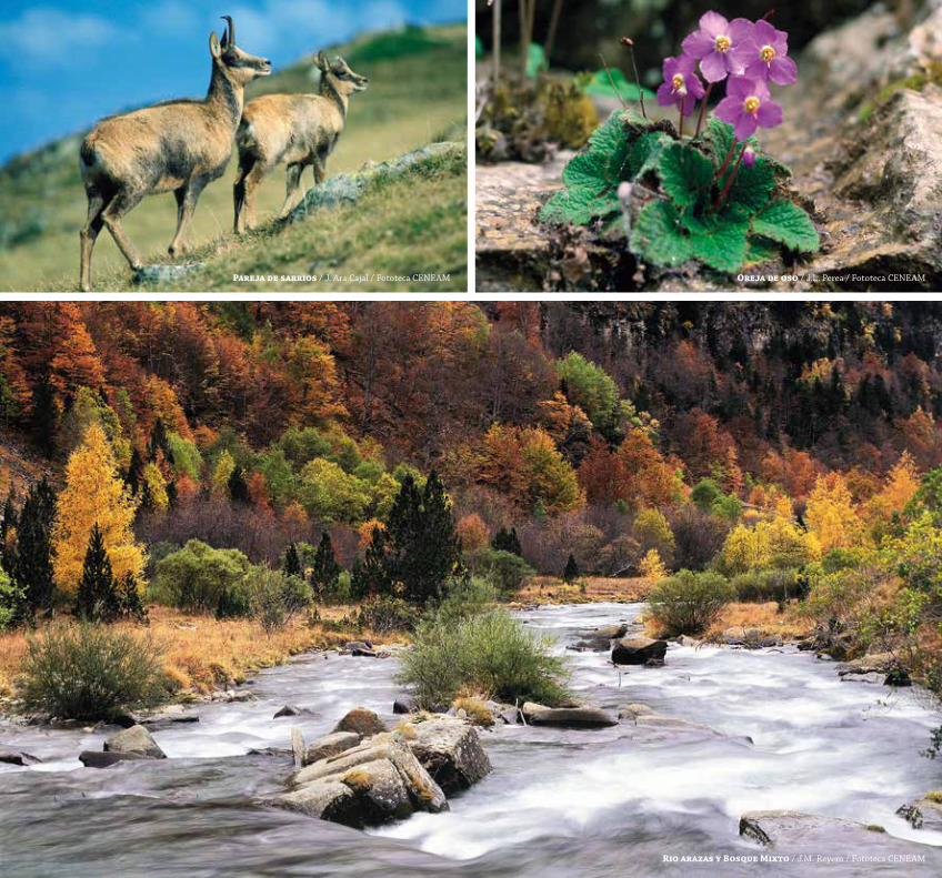
Rio arazas y Bosque Mixto / J.M. Reyero / Fototeca CENEAM
Pareja de sarrios / J. Ara Cajal / Fototeca CENEAM oreja de oso / J.L. Perea / Fototeca CENEAM
www.magrama.gob.es/es/red-parques-nacionales/nuestros-parques/teide/ www.parquesnacionalesdecanarias.es/es/teide
teidea La SoMBRa DeL voLCáN
Parque Nacional desde 1954.
Localización: En el centro de la isla de Tenerife (provincia de Santa Cruz de Tenerife).
Superficie: 18.900 ha.
altitud media: Unos 2.100 m (se desarrolla entre los 1.650 m y los 3.718 m).
Clima: Continental subalpino, con grandes variaciones térmicas.
Características: El Parque está dominado por la impresionante figura del volcán del Teide. Con sus 3.718 m es el pico más alto de España y de cualquier tierra emergida en el Océano Atlántico. Además, es el tercer volcán más grande del mundo desde su base en el lecho oceánico, sólo superado por dos volcanes en Hawai. Su extraordinario paisaje es un monumento geológico de los más espectaculares del mundo, en el que los conos volcánicos y las cladas de lava forman un extraordinario conjunto de colores y formas. El Parque fue declarado Patrimonio de la Humanidad por la UNESCO en 2007.
Sistemas naturales representados: Sistemas ligados a procesos volcánicos y vegetación asociada.
teideuNDeR the ShADow oF the voLCANo
National Park since 1954.
Location: In the centre of the island of Tenerife (Province of Santa Cruz de Tenerife).
Surface Area: 18,900 ha.
Average altitude: About 2,100m (between 1,650m and 3,718m).
Climate: Sub-alpine continental, with a large temperature range.
Characteristics: The Park is dominated by the impressive Teide volcano, at 3.718m the highest Peak in Spain and of any land emerging from the Atlantic Ocean. It is also the third largest volcano in the world, surpassed only by two volcanoes in Hawaii. Its extraordinary landscape is one of the most spectacular geological monuments in the world in which volcanic cones and lava flows comprise an extraordinary set of colours and shapes. The Park was declared a UNESCO World Heritage site in 2007.
Natural System represented: Systems connected to volcanic processes and associated plant life.
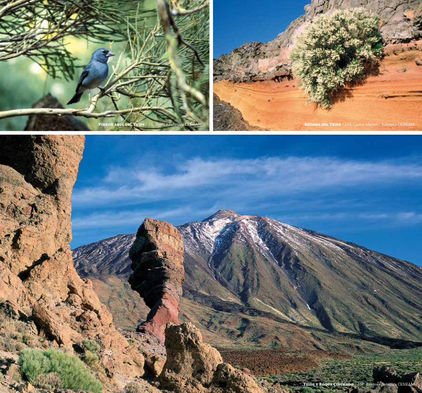
Pinzon azul del teide / J.L. Perea / Fototeca CENEAM Retama del teide / J.M. Castro Martín / Fototeca CENEAM
teide y Roque Cinchado / J.M. Reyero / Fototeca CENEAM
www.magrama.gob.es/es/red-parques-nacionales/nuestros-parques/taburiente/ www.parquesnacionalesdecanarias.es/es/Calderataburiente
caldera de taburienteRiSCoS iMPoSiBLeS
Parque Nacional desde 1954.
Localización: En el centro de la isla de La Palma, provincia de Santa Cruz de Tenerife.
Superficie: 4.690 ha.
altitud media: 1.376,60 m (444 m de altitud mínima y 2.426 m de altitud máxima).
Clima: Mediterráneo, matizado por la altitud y los vientos alisios.
Características: La parte principal del Parque es la cabecera del Barranco de Las Angustias, un enorme circo de cumbres cuya forma semicircular de 8 km de diámetro y 2.000 m de desnivel le hacen parecer un gigantesco cráter o caldera volcánica, aunque en realidad no lo sea. Su escarpado paisaje muestra crestas, llamadas aquí roques, que son el resultado de la erosión de los diferentes materiales de origen volcánico por la acción de los numerosos arroyos y torrentes espectaculares y de gran fuerza que recorren el Parque. De su valiosa biodiversidad cabe destacar la vegetación de cumbre como una de las más interesantes por acoger un mayor número de endemismos, como la bencomia, el retamón o la violeta.
Sistemas naturales representados: Sistemas ligados a procesos volcánicos y vegetación asociada.
caldera de taburiente iMPoSSiBLe CLiFFS
National Park since 1954.
Location: In the centre of the island of La Palma, Province of Santa Cruz de Tenerife.
Surface Area: 4,690 ha.
Average altitude: 1,376.6m (444m minimum altitude and 2,426m maximum altitude).
Climate: Mediterranean, influenced by the altitude and the trade winds.
Characteristics: The main part of the Park is the head of the Barranco de Las Angustias, an enormous arc of peaks 8 km in diameter and 2.000 m high which makes it look like a gigantic volcanic crater, although it is not. Its rugged landscape contains peaks —called roques here— that are the result of the erosion of the various volcanic materials by the numerous streams and spectacular and powerful torrents in the Park. The most interesting of its valuable biodiversity includes plant life at the peaks that includes a large number of endemisms such as bencomia, retamon and violet.
Natural System represented: Systems connected to volcanic processes and associated plant life.
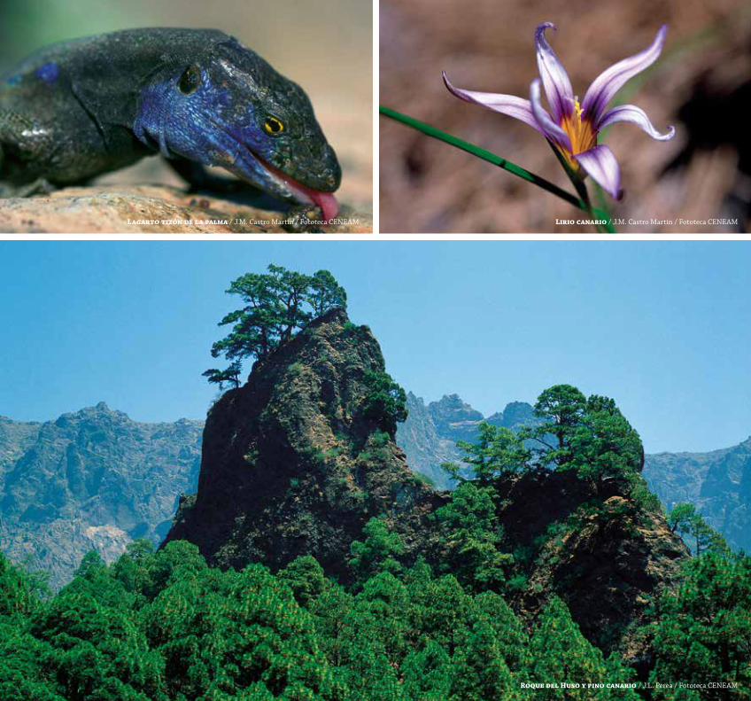
Lagarto tizón de la palma / J.M. Castro Martín / Fototeca CENEAM Lirio canario / J.M. Castro Martín / Fototeca CENEAM
Roque del Huso y pino canario / J.L. Perea / Fototeca CENEAM
www.magrama.gob.es/es/red-parques-nacionales/nuestros-parques/aiguestortes/ www.gencat.cat/parcs/aiguestortes
aiGÜestortes i estany de sant Maurici tieRRa De LaGoS
Parque Nacional desde 1955.
Localización: En el Pirineo catalán, en la provincia de Lleida.
Superficie: 40.852 ha. 14.119 ha corresponden a la zona central y 26.733 ha a la zona periférica de protección.
altitud media: Las altitudes oscilan entre los 1.090 m y los 3.033 m del punto más alto (Pic de Comaloforno). La media en la zona central es de 2.384 m y en la zona periférica de 2.213 m.
Clima: Presenta una influencia oceánica en los valles abiertos al norte y al oeste, y mediterránea en los que miran al este o al sur. En las zonas altas el clima se uniformiza y las precipitaciones de agua o de nieve pueden llegar a los 1.500 mm anuales.
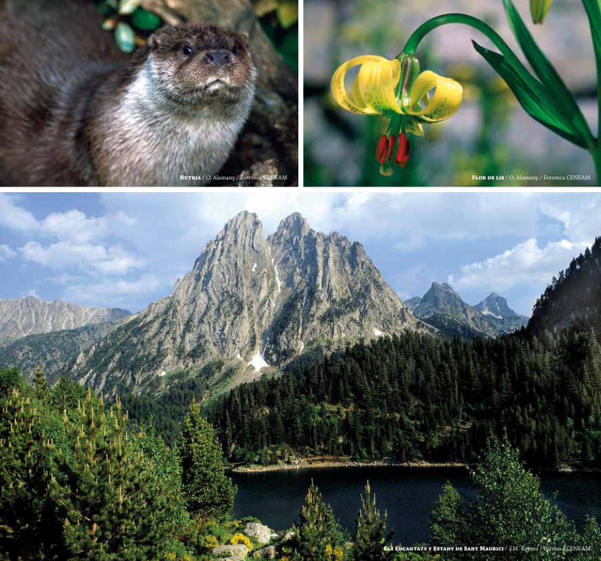
Características: El agua es la gran protagonista de este Parque y su principal seña de identidad, pues con más de 200 lagos o estanys presenta la zona lacustre más importante de los Pirineos, a los que se suman los característicos meandros de alta montaña, las aigüestortes que dan nombre al Parque, los impresionantes riscos de “Els Encantats” y los bosques de alta montaña, con abetos y pino negro, capaces de soportar los duros inviernos, mientras la nieve domina el paisaje.
Sistemas naturales representados: Sistemas ligados a formaciones lacustres y rocas de origen plutónico y fenómenos de glaciarismo.
aiGÜestortes i estany de sant Maurici LAND oF LAkeS
National Park since 1955.
Location: In the Catalan Pyrenees, in the Province of Lleida.
Surface Area: 40,852 ha. 14,119 ha in the central area and 26,733 ha in the buffer zone.
Average altitude: Altitudes go from 1,090m to 3,033m (Peak of Comaloforno). In the central area the average altitude is 2,384m and in the buffer zone it is 2,213m.
Climate: The climate is oceanic in the valleys open to the north and west, and Mediterranean in those facing east and south. In the high area, the climate is more uniform and precipitation in the form of rain or snow may reach 1,500mm per year.
Characteristics: Water plays the leading role in this Park and is also its main hallmark, since with more than 200 lakes or estanys, it is the most important lake area in the Pyrenees, together with the typical meandering high mountain streams, the aigüestortes wich give the Park its name, the impressive hillsides of Els Encantats and the high mountain woods, with fir, and black pine trees that can withstand the hard winters when snow dominates the landscape.
Natural System represented: Systems connected to lake formations and rocks of plutonic origin and glaciation phenomena.
Nutria / O. Alamany / Fototeca CENEAM Flor de lis / O. Alamany / Fototeca CENEAM
els encantats y estany de Sant Maurici / J.M. Reyero / Fototeca CENEAM
www.magrama.gob.es/es/red-parques-nacionales/nuestros-parques/donana/
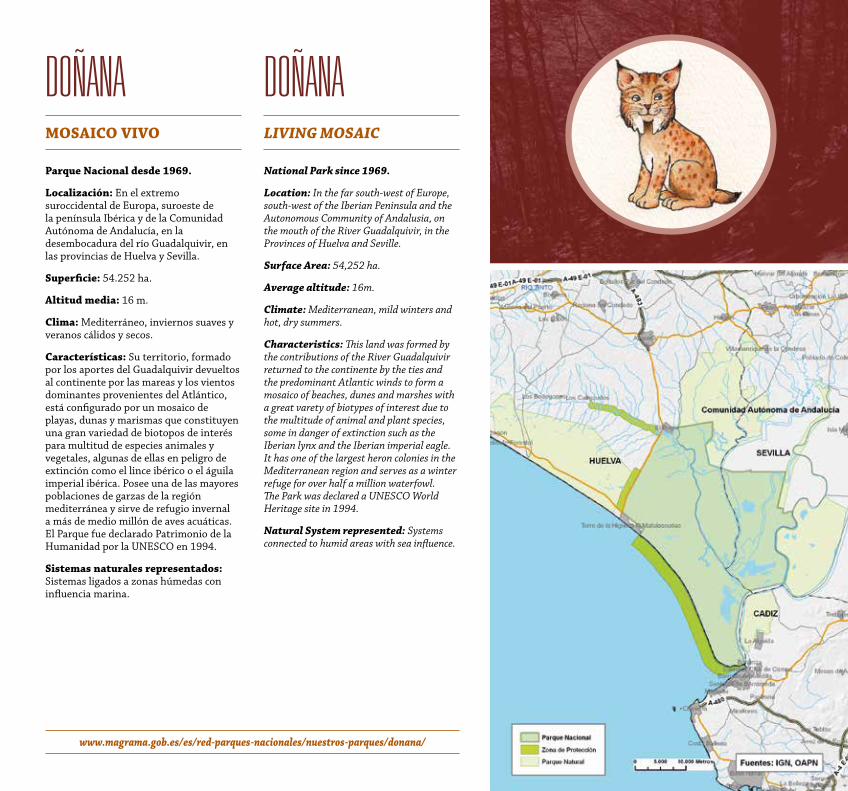
doñanaMoSaiCo vivo
Parque Nacional desde 1969.
Localización: En el extremo suroccidental de Europa, suroeste de la península Ibérica y de la Comunidad Autónoma de Andalucía, en la desembocadura del río Guadalquivir, en las provincias de Huelva y Sevilla.
Superficie: 54.252 ha.
altitud media: 16 m.
Clima: Mediterráneo, inviernos suaves y veranos cálidos y secos.
Características: Su territorio, formado por los aportes del Guadalquivir devueltos al continente por las mareas y los vientos dominantes provenientes del Atlántico, está configurado por un mosaico de playas, dunas y marismas que constituyen una gran variedad de biotopos de interés para multitud de especies animales y vegetales, algunas de ellas en peligro de extinción como el lince ibérico o el águila imperial ibérica. Posee una de las mayores poblaciones de garzas de la región mediterránea y sirve de refugio invernal a más de medio millón de aves acuáticas. El Parque fue declarado Patrimonio de la Humanidad por la UNESCO en 1994.
Sistemas naturales representados: Sistemas ligados a zonas húmedas con influencia marina.
doñanaLiviNG MoSAiC
National Park since 1969.
Location: In the far south-west of Europe, south-west of the Iberian Peninsula and the Autonomous Community of Andalusia, on the mouth of the River Guadalquivir, in the Provinces of Huelva and Seville.
Surface Area: 54,252 ha.
Average altitude: 16m.
Climate: Mediterranean, mild winters and hot, dry summers.
Characteristics: This land was formed by the contributions of the River Guadalquivir returned to the continente by the ties and the predominant Atlantic winds to form a mosaico of beaches, dunes and marshes with a great varety of biotypes of interest due to the multitude of animal and plant species, some in danger of extinction such as the Iberian lynx and the Iberian imperial eagle. It has one of the largest heron colonies in the Mediterranean region and serves as a winter refuge for over half a million waterfowl. The Park was declared a UNESCO World Heritage site in 1994.
Natural System represented: Systems connected to humid areas with sea influence.
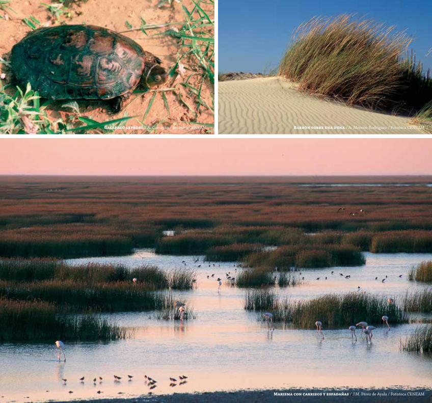
Galápago leproso / A. Camoyán / Fototeca CENEAM Barrón sobre una duna / A. Moreno Rodríguez / Fototeca CENEAM
Marisma con carrizos y espadañas / J.M. Pérez de Ayala / Fototeca CENEAM
www.magrama.gob.es/es/red-parques-nacionales/nuestros-parques/daimiel/
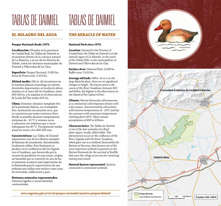
tablas de daiMieleL MiLaGRo DeL aGua
Parque Nacional desde 1973.
Localización: Situadas en la provincia de Ciudad Real, las Tablas de Daimiel se encuentran dentro de la comarca natural de La Mancha, y al sur de los Montes de Toledo, entre los términos municipales de Daimiel y Villarrubia de los Ojos.
Superficie: Parque Nacional, 3.030 ha. Zona de Protección, 5.410 ha.
altitud media: 606 m. Al encontrarse en la inmensa planicie manchega no existen desniveles importantes; se localiza la altura mínima en el cauce del río Guadiana, entre 603-604 m, y la máxima en el observatorio de la isla del Pan (sobre 610 m).
Clima: Dominio climático templado frío de la península Ibérica, en el templado frío continental con estación seca, que se caracteriza por tener inviernos fríos donde se pueden alcanzar temperaturas extremas de –10 ºC y veranos secos y calurosos con máximas que a veces sobrepasan los 40 ºC. Precipitación media anual en torno a los 400-450 mm.
Características: Las Tablas de Daimiel representan uno de los últimos ejemplos de llanuras de inundación, denominadas localmente tablas. Este fenómeno se produce en la confluencia del río Gigüela con el Guadiana, que favorecido por la escasez de pendiente en esas zonas, origina un humedal que se convirtió en uno de los ecosistemas acuáticos más importantes de la Península para la supervivencia de una avifauna que utiliza este enclave como zona de invernada, nidificación y paso.
Sistemas naturales representados: Sistemas ligados a zonas húmedas continentales.
tablas de daiMielthe MiRACLe oF wAteR
National Park since 1973.
Location: Situated in the Province of Ciudad Real, the Tablas de Daimiel is in the natural region of La Mancha, to the south of the Toledo Hills, in the municipalities of Daimiel and Villarrubia de los Ojos.
Surface Area: National Park: 3,030 ha. Buffer zone: 5,410 ha.
Average altitude: 606m. As it is on the large Mancha plain, there are no significant changes in height. The lowest point is the course of the River Guadiana, between 603 and 604m, the highest is the observatory on the Island of Pan (about 610m).
Climate: Iberian Peninsula cold temperate, as a continental cold temperate climate with a dry season, characterised by cold winters with extreme temperatures of –10ºC and hot dry summers with maximum temperatures reaching above 40ºC. Mean annual precipitation of 400 to 450mm.
Characteristics: The Tablas de Daimiel is one of the last examples of a floyd plain region, locally called tablas. This phenomenon occurs at the confluence of the River Gigüela with the River Guadiana, which gave rise to a wetland, favoured by the flatness of the area, that became one of the most important wetland ecosystems on the Iberian Peninsula for the survival of birdlife that uses this refuge as an area for wintering nesting and transit.
Natural System represented: Systems connected to continental wetlands.
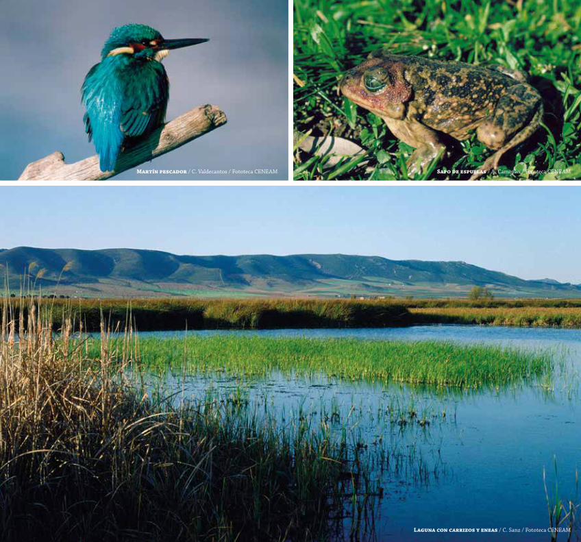
Martín pescador / C. Valdecantos / Fototeca CENEAM Sapo de espuelas / A. Camoyán / Fototeca CENEAM
Laguna con carrizos y eneas / C. Sanz / Fototeca CENEAM
www.magrama.gob.es/es/red-parques-nacionales/nuestros-parques/timanfaya/ http://www.parquesnacionalesdecanarias.es/es/timanfaya
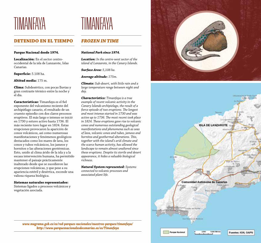
tiManfayaDeteNiDo eN eL tieMPo
Parque Nacional desde 1974.
Localización: En el sector centro-occidental de la isla de Lanzarote, Islas Canarias.
Superficie: 5.108 ha.
altitud media: 175 m.
Clima: Subdesértico, con pocas lluvias y gran contraste térmico entre la noche y el día.
Características: Timanfaya es el fiel exponente del vulcanismo reciente del archipiélago canario, el resultado de un cruento episodio con dos claros procesos eruptivos. El más largo e intenso se inició en 1730 y estuvo activo hasta 1736. El más reciente tuvo lugar en 1824. Estas erupciones provocaron la aparición de conos volcánicos, así como numerosas manifestaciones y fenómenos geológicos destacados como los mares de lava, los conos y tubos volcánicos, los jameos y hornitos o las alteraciones geotérmicas. Esto, unido al clima árido de la isla y a la escasa intervención humana, ha permitido mantener el paisaje prácticamente inalterado desde que se sucedieron las erupciones volcánicas, y que pese a su apariencia estéril y desértica, esconde una valiosa riqueza biológica.
Sistemas naturales representados: Sistemas ligados a procesos volcánicos y vegetación asociada.
tiManfayaFRozeN iN tiMe
National Park since 1974.
Location: In the centre-west sector of the island of Lanzarote, in the Canary Islands.
Surface Area: 5,108 ha.
Average altitude: 175m.
Climate: Sub-desert, with little rain and a large temperature range between night and day.
Characteristics: Timanfaya is a trae example of recent volcanic activity in the Canary Islands archipielago, the result of a fierce episode of two eruptions. The longest and most intense started in 1730 and was active up to 1736. The most recent took place in 1824. These eruptions gave rise to volcanic cones and numerous outstanding geological manifestations and phenomena such as seas of lava, volcanic cones and tubes, jameos and hornitos and geothermal alterations. This, together with the island’s arid climate and the scarce human activity, has allowed the landscape to remain almost unaltered since these eruptions. Despite its sterile and desert appearance, it hides a valuable biological richness.
Natural System represented: Systems connected to volcanic processes and associated plant life.
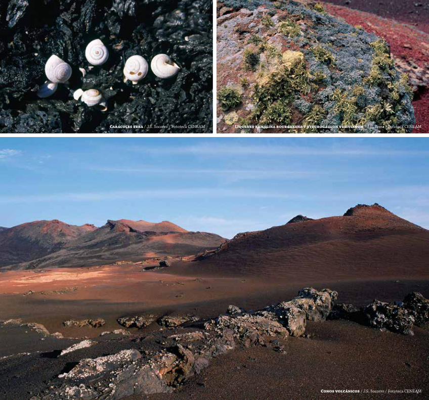
Caracoles teba / J.S. Socorro / Fototeca CENEAM Líquenes ramalina bourgaeana y steurogaulon vesivianum / J.L. Perea / Fototeca CENEAM
Conos volcánicos / J.S. Socorro / Fototeca CENEAM
www.magrama.gob.es/es/red-parques-nacionales/nuestros-parques/garajonay/ http://www.parquesnacionalesdecanarias.es/es/Garajonay
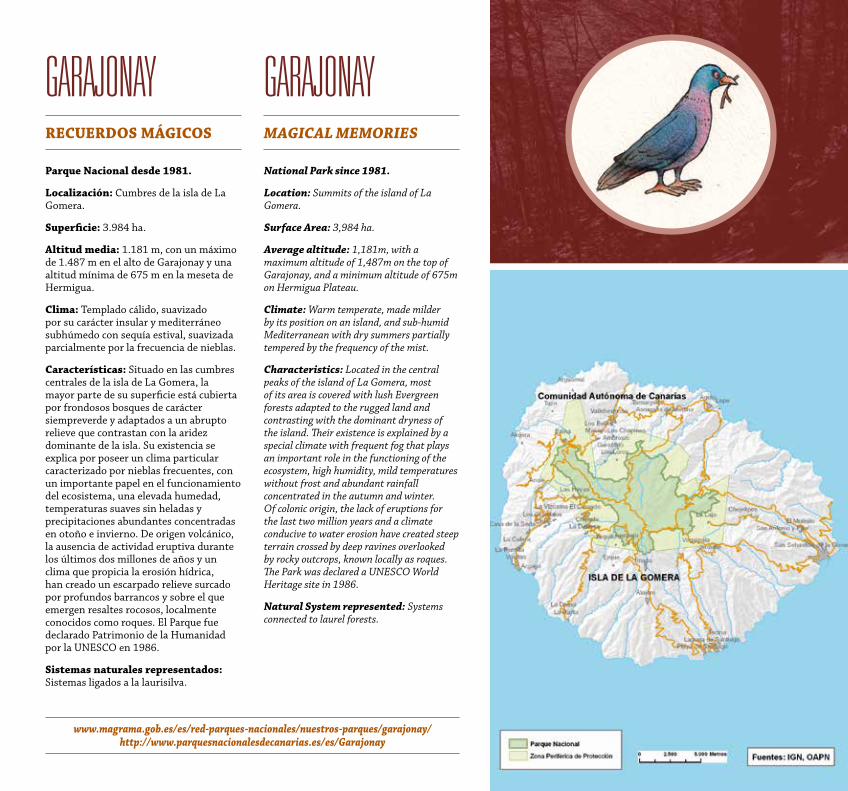
GarajonayReCueRDoS MáGiCoS
Parque Nacional desde 1981.
Localización: Cumbres de la isla de La Gomera.
Superficie: 3.984 ha.
altitud media: 1.181 m, con un máximo de 1.487 m en el alto de Garajonay y una altitud mínima de 675 m en la meseta de Hermigua.
Clima: Templado cálido, suavizado por su carácter insular y mediterráneo subhúmedo con sequía estival, suavizada parcialmente por la frecuencia de nieblas.
Características: Situado en las cumbres centrales de la isla de La Gomera, la mayor parte de su superficie está cubierta por frondosos bosques de carácter siempreverde y adaptados a un abrupto relieve que contrastan con la aridez dominante de la isla. Su existencia se explica por poseer un clima particular caracterizado por nieblas frecuentes, con un importante papel en el funcionamiento del ecosistema, una elevada humedad, temperaturas suaves sin heladas y precipitaciones abundantes concentradas en otoño e invierno. De origen volcánico, la ausencia de actividad eruptiva durante los últimos dos millones de años y un clima que propicia la erosión hídrica, han creado un escarpado relieve surcado por profundos barrancos y sobre el que emergen resaltes rocosos, localmente conocidos como roques. El Parque fue declarado Patrimonio de la Humanidad por la UNESCO en 1986.
Sistemas naturales representados: Sistemas ligados a la laurisilva.
GarajonayMAGiCAL MeMoRieS
National Park since 1981.
Location: Summits of the island of La Gomera.
Surface Area: 3,984 ha.
Average altitude: 1,181m, with a maximum altitude of 1,487m on the top of Garajonay, and a minimum altitude of 675m on Hermigua Plateau.
Climate: Warm temperate, made milder by its position on an island, and sub-humid Mediterranean with dry summers partially tempered by the frequency of the mist.
Characteristics: Located in the central peaks of the island of La Gomera, most of its area is covered with lush Evergreen forests adapted to the rugged land and contrasting with the dominant dryness of the island. Their existence is explained by a special climate with frequent fog that plays an important role in the functioning of the ecosystem, high humidity, mild temperatures without frost and abundant rainfall concentrated in the autumn and winter. Of colonic origin, the lack of eruptions for the last two million years and a climate conducive to water erosion have created steep terrain crossed by deep ravines overlooked by rocky outcrops, known locally as roques. The Park was declared a UNESCO World Heritage site in 1986.
Natural System represented: Systems connected to laurel forests.
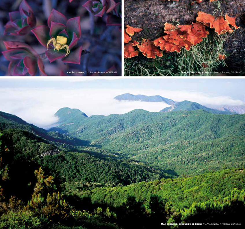
araña tomiso / J.L. Perea / Fototeca CENEAM Barbas de capuchino / J.L. Perea / Fototeca CENEAM
Mar de nubes. bosque de el Cedro / C. Valdecantos / Fototeca CENEAM
www.magrama.gob.es/es/red-parques-nacionales/nuestros-parques/cabrera/
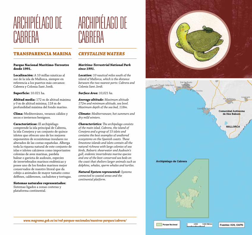
archiPiélaGo de cabrera tRaNSPaReNCia MaRiNa
Parque Nacional Marítimo-terrestre desde 1991.
Localización: A 10 millas náuticas al sur de la isla de Mallorca, siempre en referencia a los puertos más cercanos: Cabrera y Colonia Sant Jordi.
Superficie: 10.021 ha.
altitud media: 172 m de altitud máxima y 0 m de altitud mínima; 118 m de profundidad máxima del fondo marino.
Clima: Mediterráneo, veranos cálidos y secos e inviernos benignos.
Características: El archipiélago comprende la isla principal de Cabrera, la isla Conejera y un conjunto de quince islotes que ofrecen uno de los mejores exponentes de ecosistemas insulares no alterados de las costas españolas. Alberga toda la riqueza natural de este conjunto de islas e islotes calcáreos como importantes colonias de aves marinas, pardela balear o gaviota de audouin, especies de invertebrados marinos endémicas y posee uno de los fondos marinos mejor conservados de nuestro litoral que da cobijo a animales de mayor tamaño como delfines, calderones, cachalotes y tortugas.
Sistemas naturales representados: Sistemas ligados a zonas costeras y plataforma continental.
archiPiélaGo de cabrera CRyStALiNe wAteRS
Maritime-terrestrial National Park since 1991.
Location: 10 nautical miles south of the island of Mallorca, which is the distance between the two nearest ports: Cabrera and Colonia Sant Jordi.
Surface Area: 10,021 ha.
Average altitude: Maximum altitude 172m and minimum altitude, sea level. Maximum depth of the sea bed, 118m.
Climate: Mediterranean; hot summers and dry mild winters.
Characteristics: The archipelago consists of the main islad, Cabrera, the island of Conejera and a group of 15 islets and contains the best examples of unaltered ecosystems on the Spanish coasts. These limestone islands and islets contain all the natural richness with large colonies of sea birds, Balearic shearwater and Audouin’s gull, endemic invertebrate marine species and one of the best-conserved sea beds on the coast that shelters larger animals such as dolphins, whales, sperm whales and turtles.
Natural System represented: Systems connected to coastal areas and the continental platform.
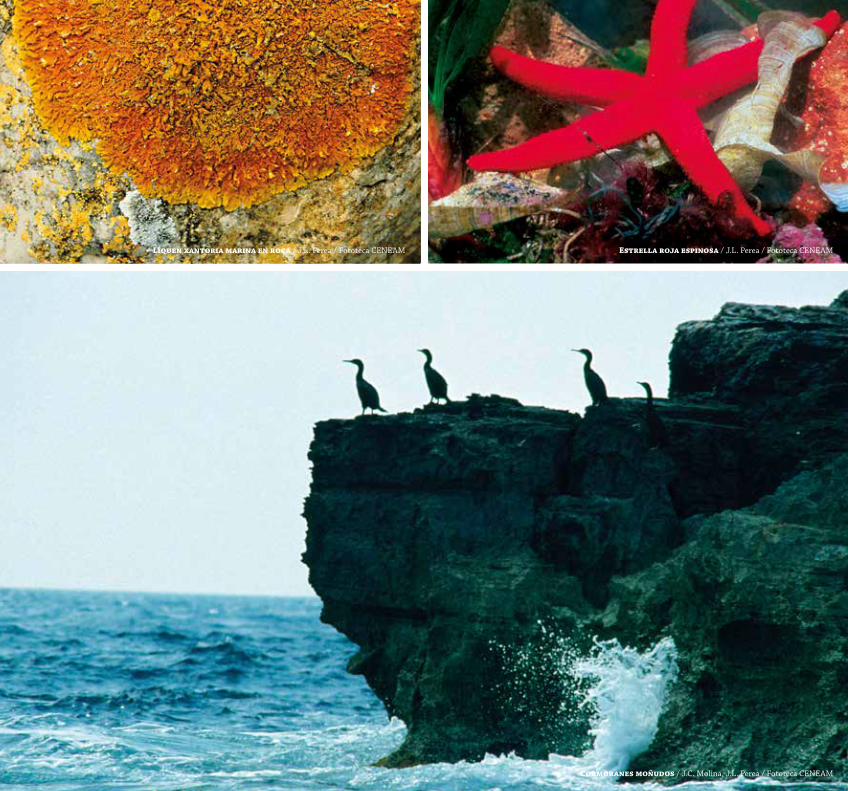
Líquen xantoria marina en roca / J.L. Perea / Fototeca CENEAM estrella roja espinosa / J.L. Perea / Fototeca CENEAM
Cormoranes moñudos / J.C. Molina, J.L. Perea / Fototeca CENEAM
www.magrama.gob.es/es/red-parques-nacionales/nuestros-parques/cabaneros/
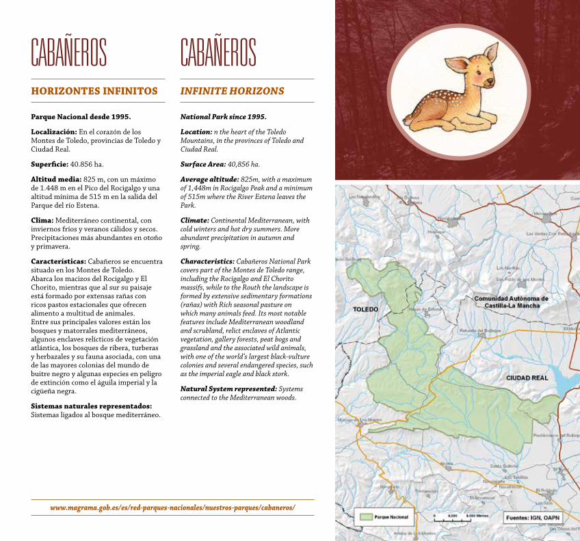
cabañerosHoRizoNteS iNFiNitoS
Parque Nacional desde 1995.
Localización: En el corazón de los Montes de Toledo, provincias de Toledo y Ciudad Real.
Superficie: 40.856 ha.
altitud media: 825 m, con un máximo de 1.448 m en el Pico del Rocigalgo y una altitud mínima de 515 m en la salida del Parque del río Estena.
Clima: Mediterráneo continental, con inviernos fríos y veranos cálidos y secos. Precipitaciones más abundantes en otoño y primavera.
Características: Cabañeros se encuentra situado en los Montes de Toledo. Abarca los macizos del Rocigalgo y El Chorito, mientras que al sur su paisaje está formado por extensas rañas con ricos pastos estacionales que ofrecen alimento a multitud de animales. Entre sus principales valores están los bosques y matorrales mediterráneos, algunos enclaves relícticos de vegetación atlántica, los bosques de ribera, turberas y herbazales y su fauna asociada, con una de las mayores colonias del mundo de buitre negro y algunas especies en peligro de extinción como el águila imperial y la cigüeña negra.
Sistemas naturales representados: Sistemas ligados al bosque mediterráneo.
cabañerosiNFiNite hoRizoNS
National Park since 1995.
Location: n the heart of the Toledo Mountains, in the provinces of Toledo and Ciudad Real.
Surface Area: 40,856 ha.
Average altitude: 825m, with a maximum of 1,448m in Rocigalgo Peak and a minimum of 515m where the River Estena leaves the Park.
Climate: Continental Mediterranean, with cold winters and hot dry summers. More abundant precipitation in autumn and spring.
Characteristics: Cabañeros National Park covers part of the Montes de Toledo range, including the Rocigalgo and El Chorito massifs, while to the Routh the landscape is formed by extensive sedimentary formations (rañas) with Rich seasonal pasture on which many animals feed. Its most notable features include Mediterranean woodland and scrubland, relict enclaves of Atlantic vegetation, gallery forests, peat bogs and grassland and the associated wild animals, with one of the world’s largest black-vulture colonies and several endangered species, such as the imperial eagle and black stork.
Natural System represented: Systems connected to the Mediterranean woods.
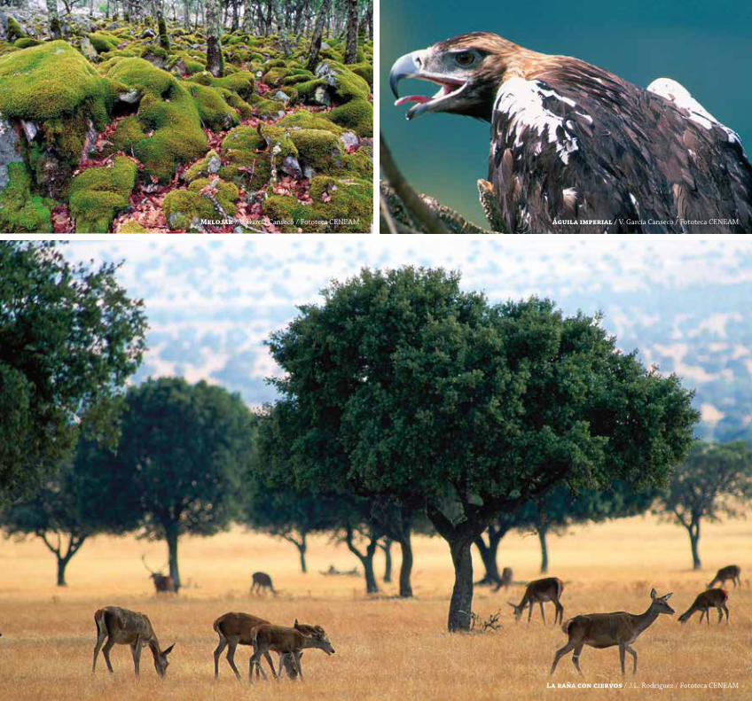
Melojar / V. García Canseco / Fototeca CENEAM águila imperial / V. García Canseco / Fototeca CENEAM
La raña con ciervos / J.L. Rodríguez / Fototeca CENEAM
www.magrama.gob.es/es/red-parques-nacionales/nuestros-parques/sierra-nevada/ www.juntadeandalucia.es/organismos/medioambienteyordenaciondelterritorio/areas.html
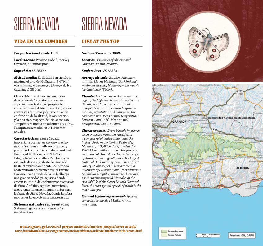
sierra nevadaviDa eN LaS CuMBReS
Parque Nacional desde 1999.
Localización: Provincias de Almería y Granada, 44 municipios.
Superficie: 85.883 ha.
altitud media: Es de 2.145 m siendo la máxima el pico de Mulhacén (3.479 m) y la mínima, Montenegro (Arroyo de los Catalanes) (860 m).
Clima: Mediterráneo. Su condición de alta montaña confiere a la zona superior características propias de un clima continental frío. Presenta grandes contrastes térmicos y de precipitación en función de la altitud, la orientación y la posición respecto del eje oeste-este. Temperatura media anual entre 1 y 14 ºC. Precipitación media, 450-1.500 mm anuales.
Características: Sierra Nevada impresiona por ser un extenso macizo montañoso con un relieve compacto y por tener la cima más alta de la península Ibérica, el Mulhacén, con 3.479 m. Integrado en la cordillera Penibética, se extiende desde el sudeste de Granada hasta el extremo occidental de Almería, abarcando ambas vertientes. El Parque Nacional más grande de la Red, alberga una gran variedad paisajística donde crecen multitud de endemismos exclusivos de flora. Anfibios, reptiles, mamíferos, aves y una rica entomofauna conforman la fauna de Sierra Nevada, donde la cabra montés es la especie más característica.
Sistemas naturales representados: Sistemas ligados a la alta montaña mediterránea.
sierra nevadaLiFe At the toP
National Park since 1999.
Location: Provinces of Almería and Granada, 44 municipalities.
Surface Area: 85,883 ha.
Average altitude: 2,145m. Maximum altitude, Mount Mulhacén (3,479m) and minimum altitude, Montenegro (Arroyo de los Catalanes) (860m).
Climate: Mediterranean. As a mountain region, the high land has a cold continental climate, with large temperature and precipitation contrasts depending on the altitude, orientation and position on the east-west axis. Mean annual temperature between 1 and 14ºC. Mean annual precipitation, 450-1,500mm.
Characteristics: Sierra Nevada impresses as an extensive mountain massif with a compact relief and because it has the highest Peak on the Iberian Peninsula, Mulhacén, at 3,479m. Integrated in the Penibética cordillera, it stretches from the south east of Granada to the western edge of Almeria, covering both sides. The largest National Oark in the system, it has a great variety of landscapes in which there is a multitude of exclusive plant life encdemisms. Amphibians, reptiles, mammals, birds and a rich surrounding wild life make up the rich wildlife of the Sierra Nevada National Park, the most typical species of which is the mountain goat.
Natural System represented: Systems connected to the high Mediterranean mountains.
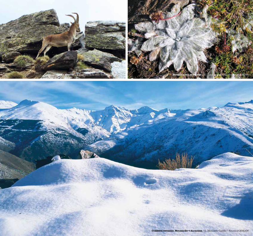
Cabra montés / F. Castellón de la Hoz / Fototeca CENEAM estrella de las nieves / F.J. Sánchez Gutiérrez / Fototeca CENEAM
Cumbres nevadas. Mulhacén y alcazaba / G. Montañés Castillo / Fototeca CENEAM
www.magrama.gob.es/es/red-parques-nacionales/nuestros-parques/islas-atlanticas/ www.parquenacionalillasatlanticas.com
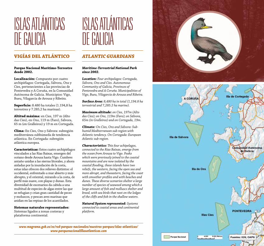
islas atlánticas de Galicia viGíaS DeL atLáNtiCo
Parque Nacional Marítimo-terrestre desde 2002.
Localización: Compuesto por cuatro archipiélagos: Cortegada, Sálvora, Ons y Cíes, pertenecientes a las provincias de Pontevedra y A Coruña, en la Comunidad Autónoma de Galicia. Municipios: Vigo, Bueu, Vilagarcía de Arousa y Ribeira.
Superficie: 8.480 ha totales (1.194,8 ha terrestres y 7.285,2 ha marinas).
altitud máxima: en Cíes, 197 m (Alto das Cíes), en Ons, 119 m (Faro), Sálvora, 65 m (en Gralleiros) y 19 m en Cortegada.
Clima: En Cíes, Ons y Sálvora: subregión mediterránea subhúmeda de tendencia atlántica. En Cortegada: subregión atlántica europea.
Características: Estos cuatro archipiélagos vinculados a las Rías Baixas, emergen del océano desde Arousa hasta Vigo. Cumbres antaño unidas a las sierras litorales, y ahora aisladas por la inundación de la costa, estas islas ofrecen dos relieves distintos: el occidental, enfrentado a mar abierto y más abrupto, y el oriental, mirando a la costa, de perfil más suave, con playas y dunas. Esta diversidad de escenarios da cabida a una multitud de especies de algas entre las que se refugian y crían gran cantidad de peces y moluscos, y pescan aves marinas que anidan en las repisas de los acantilados.
Sistemas naturales representados: Sistemas ligados a zonas costeras y plataforma continental.
islas atlánticas de Galicia AtLANtiC GuARDiANS
Maritime-terrestrial National Park since 2002.
Location: Four archipelagos: Cortegada, Sálvora, Ons and Cíes. Autonomous Community of Galicia, Provinces of Pontevedra and A Coruña. Municipalities of Vigo, Bueu, Vilagarcía de Arousa and Ribeira.
Surface Area: 8,480 ha in total (1,194.8 ha terrestrial and 7,285.2 ha marine).
Maximum altitude: on Cíes, 197m (Alto das Cíes); on Ons, 119m (Faro); on Sálvora, 65m (in Gralleiros) and on Cortegada, 19m.
Climate: On Cíes, Ons and Sálvora: Sub-humid Mediterranean sub-region with Atlantic tendency. On Cortegada: European Atlantic sub-region.
Characteristics: This four achipelagos, connected to the Rías Baixas, emerge from the ocean from Arousa to Vigo. Peaks which were previously joined to the coastal mountains and are now isolated by the coastal flooding, these islands have two reliefs, the western, facing the open sea and more abrupt, and theeastern, facing the coast with smoother profiles and with beaches and dunes. These diverse scenarios shelter a large number of species of seaweed among which a large amount of fish and molluscs shelter and breed, with sea birds that nest on the ledges of the cliffs and fish in the shallow waters.
Natural System represented: Systems connected to coastal areas and continental platform.
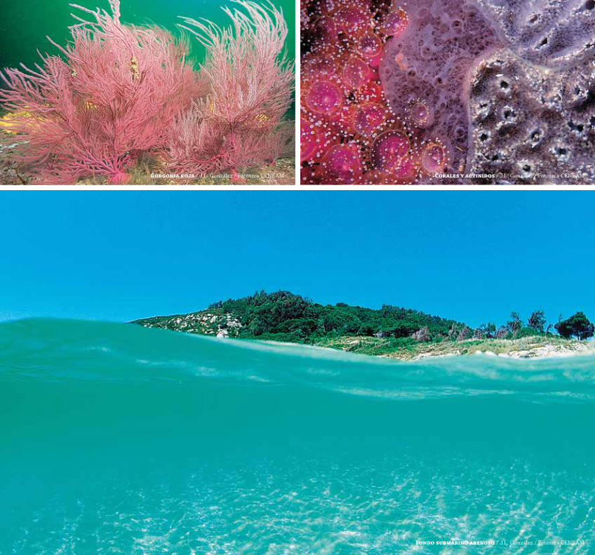
Gorgonia roja / J.L. González / Fototeca CENEAM Corales y actinidos / J.L. González / Fototeca CENEAM
Fondo submarino arenoso / J.L. González / Fototeca CENEAM
www.magrama.gob.es/es/red-parques-nacionales/nuestros-parques/monfrague/ extremambiente.gobex.es/index.php?option=com_content&view=article&id=228&itemid=77
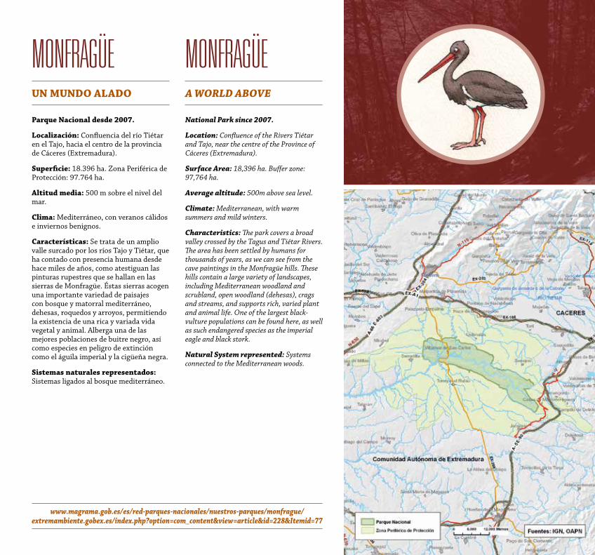
MonfraGÜeuN MuNDo aLaDo
Parque Nacional desde 2007.
Localización: Confluencia del río Tiétar en el Tajo, hacia el centro de la provincia de Cáceres (Extremadura).
Superficie: 18.396 ha. Zona Periférica de Protección: 97.764 ha.
altitud media: 500 m sobre el nivel del mar.
Clima: Mediterráneo, con veranos cálidos e inviernos benignos.
Características: Se trata de un amplio valle surcado por los ríos Tajo y Tiétar, que ha contado con presencia humana desde hace miles de años, como atestiguan las pinturas rupestres que se hallan en las sierras de Monfragüe. Éstas sierras acogen una importante variedad de paisajes con bosque y matorral mediterráneo, dehesas, roquedos y arroyos, permitiendo la existencia de una rica y variada vida vegetal y animal. Alberga una de las mejores poblaciones de buitre negro, así como especies en peligro de extinción como el águila imperial y la cigüeña negra.
Sistemas naturales representados: Sistemas ligados al bosque mediterráneo.
MonfraGÜeA woRLD ABove
National Park since 2007.
Location: Confluence of the Rivers Tiétar and Tajo, near the centre of the Province of Cáceres (Extremadura).
Surface Area: 18,396 ha. Buffer zone: 97,764 ha.
Average altitude: 500m above sea level.
Climate: Mediterranean, with warm summers and mild winters.
Characteristics: The park covers a broad valley crossed by the Tagus and Tiétar Rivers. The area has been settled by humans for thousands of years, as we can see from the cave paintings in the Monfragüe hills. These hills contain a large variety of landscapes, including Mediterranean woodland and scrubland, open woodland (dehesas), crags and streams, and supports rich, varied plant and animal life. One of the largest black-vulture populations can be found here, as well as such endangered species as the imperial eagle and black stork.
Natural System represented: Systems connected to the Mediterranean woods.
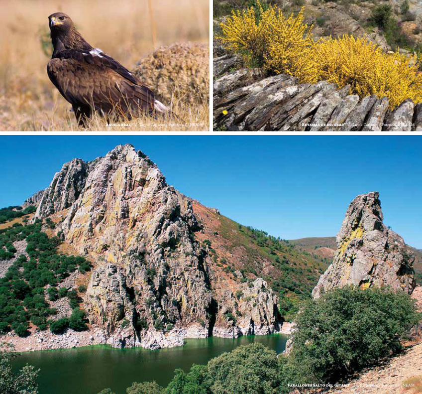
águila real / V. García Canseco / Fototeca CENEAM Retamas de escobas / V. García Canseco / Fototeca CENEAM
Farallones Salto del Gitano / J.L. Rodríguez / Fototeca CENEAM
www.magrama.gob.es/es/red-parques-nacionales/nuestros-parques/guadarrama/
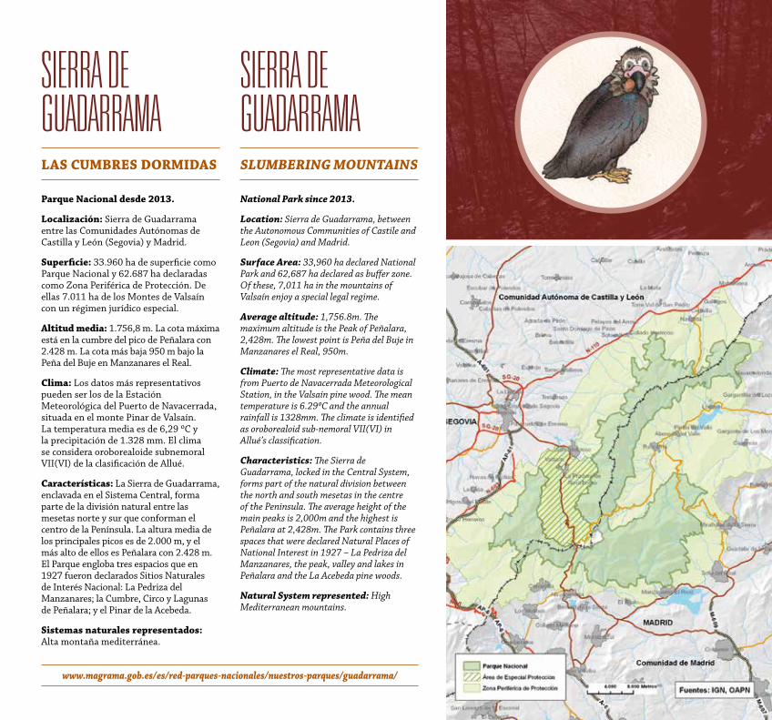
sierra de GuadarraMa LaS CuMBReS DoRMiDaS
Parque Nacional desde 2013.
Localización: Sierra de Guadarrama entre las Comunidades Autónomas de Castilla y León (Segovia) y Madrid.
Superficie: 33.960 ha de superficie como Parque Nacional y 62.687 ha declaradas como Zona Periférica de Protección. De ellas 7.011 ha de los Montes de Valsaín con un régimen jurídico especial.
altitud media: 1.756,8 m. La cota máxima está en la cumbre del pico de Peñalara con 2.428 m. La cota más baja 950 m bajo la Peña del Buje en Manzanares el Real.
Clima: Los datos más representativos pueden ser los de la Estación Meteorológica del Puerto de Navacerrada, situada en el monte Pinar de Valsaín. La temperatura media es de 6,29 ºC y la precipitación de 1.328 mm. El clima se considera oroborealoide subnemoral VII(VI) de la clasificación de Allué.
Características: La Sierra de Guadarrama, enclavada en el Sistema Central, forma parte de la división natural entre las mesetas norte y sur que conforman el centro de la Península. La altura media de los principales picos es de 2.000 m, y el más alto de ellos es Peñalara con 2.428 m. El Parque engloba tres espacios que en 1927 fueron declarados Sitios Naturales de Interés Nacional: La Pedriza del Manzanares; la Cumbre, Circo y Lagunas de Peñalara; y el Pinar de la Acebeda.
Sistemas naturales representados: Alta montaña mediterránea.
sierra de GuadarraMa SLuMBeRiNG MouNtAiNS
National Park since 2013.
Location: Sierra de Guadarrama, between the Autonomous Communities of Castile and Leon (Segovia) and Madrid.
Surface Area: 33,960 ha declared National Park and 62,687 ha declared as buffer zone. Of these, 7,011 ha in the mountains of Valsaín enjoy a special legal regime.
Average altitude: 1,756.8m. The maximum altitude is the Peak of Peñalara, 2,428m. The lowest point is Peña del Buje in Manzanares el Real, 950m.
Climate: The most representative data is from Puerto de Navacerrada Meteorological Station, in the Valsaín pine wood. The mean temperature is 6.29ºC and the annual rainfall is 1328mm. The climate is identified as oroborealoid sub-nemoral VII(VI) in Allué’s classification.
Characteristics: The Sierra de Guadarrama, locked in the Central System, forms part of the natural division between the north and south mesetas in the centre of the Peninsula. The average height of the main peaks is 2,000m and the highest is Peñalara at 2,428m. The Park contains three spaces that were declared Natural Places of National Interest in 1927 – La Pedriza del Manzanares, the peak, valley and lakes in Peñalara and the La Acebeda pine woods.
Natural System represented: High Mediterranean mountains.
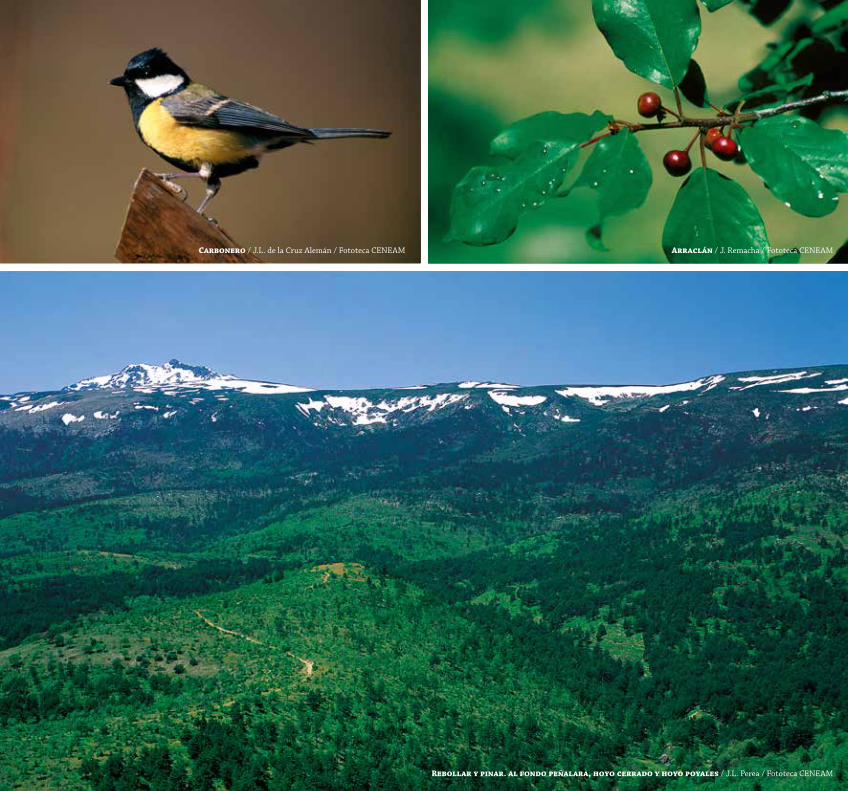
Carbonero / J.L. de la Cruz Alemán / Fototeca CENEAM arraclán / J. Remacha / Fototeca CENEAM
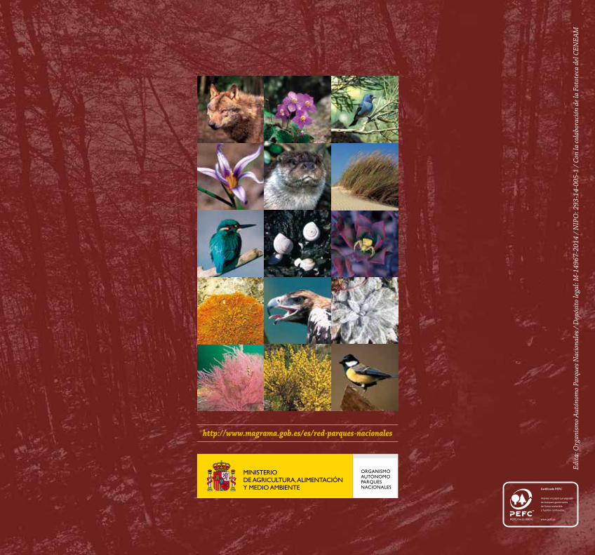
Rebollar y pinar. al fondo peñalara, hoyo cerrado y hoyo poyales / J.L. Perea / Fototeca CENEAM
http://www.magrama.gob.es/es/red-parques-nacionales
Edit
a: O
rgan
ism
o A
utón
omo
Parq
ues N
acio
nale
s / D
epós
ito le
gal:
M-1
4967
-201
4 /
NIP
O: 2
93-1
4-00
5-1
/ Co
n la
cola
bora
ción
de
la F
otot
eca
del C
ENEA
M