PUBLICACIONES DEL INSTITUTO GEOLOGICO Y MINERO DE ...
260
PUBLICACIONES DEL INSTITUTO GEOLOGICO Y MINERO DE ESPANA I Serie: CUADERNOS DEL MUSEO GEOMINERO. N° 13 Instrtuto Geokbgico 0 > y Mineno de Espafta
Transcript of PUBLICACIONES DEL INSTITUTO GEOLOGICO Y MINERO DE ...
PUBLICACIONES DEL INST ITUTO G E O L O G I C O Y M I N E R O DE ESPANA I Serie: C U A D E R N O S DEL M U S E O G E O M I N E R O . N° 13
Instrtuto Geokbgico 0 > y Mineno de Espafta


HISTORY OF RESEARCH IN MINERAL RESOURCES
Edited by
Jose Eugenio Ortiz Octavio Puche Isabel Rabano
Luis. F. Mazadiego
2011 Published by
Institute) Geolog ico y Minero de Espana Madr id

Series: CUADERNOS DEL MUSEO GEOMINERO, N'° 13
Conference of the International Commission on the History of Geological Sciences (INHIGEO) (35. 2010. Madrid y Almaden)
History of research in mineral resources, 35th Conference of the International Commission on the History of Geological Sciences (INHIGEO) Madrid y Almaden (Espaha), 1-14 Julio 2010/J.E Ortiz, 0. Puche, I. Rabano y L.P. Mazadiego, eds.- Madrid: Instituto Geologico y Minero de Espana, 2011 .
405 pgs; ils; 17cm .- (Cuadernos del Museo Geominero: 13}
ISBN 9/8-84-7840-856-6
1 - Recurso minero. 2. Historia. 3. Congreso. I. Instituto Geologico y Minero de Espaha, ed. II. Ortiz, J.E., ed. III. Puche, 0 „ ed. IV. Rabano, l „ ed. V. Mazadiego, L. P., ed. VI, Serie,
622:93
All rights reserved. No part of this publication may be reproduced or transmitted in any form or by any means, electronic or mechanical, including photocopy, recording, or any information storage and retrieval system now known or to be invented, without permission in writing from the publisher.
References to this volume
It is recommended that either of the fol lowing alternatives should be used for future bibliographic references lo the whole or part of this volume:
Ortiz, J. E., Puche, O.; Rabano, I. and Mazadiego, L. F. ,(eds.) 2011 . History of Research in Mineral Resources. Cuadernos del Museo Geominero n,° 13. Instituto Geologico y Minero de Espaha, Madrid, 405 pp.
Oldroyd, D, 2011. A brief history of the sapphire industry in Queensland. In: Ortiz, J. E,; Puche, 0.; Rabano, I. and Mazadiego, L. F. (eds). History of Research in Mineral Resources, Cuadernos del Museo Geominero n.° 13. Instituto Geologico y Minero de Espaha, Madrid, 155-166.
Cover illustration: Mercury distillation furnaces of San Eugenio and San Julian, which worked between 1720 and 1928 in Almaden, as part of the complex "Aludeles and Bustamante furnaces". Almaden Mining Park (Ciudad Real, Spain). Photograph by Juan Carlos Gutierrez-Marco (CSIC, Madrid).
© INSTITUTO GEOLOGICO Y MINERO DE ESPANA Rios Rosas, 23. 28003 Madrid www.lgme.es
NIPO: 474-11-005-8 ISBN 978-84-7840-856-6 Deposito Legal: M-17678-2011
O f i ' i r a T 3 : B a n & c S Azgcc

CONTENTS
Foreword VII
Introduct ion IX
NEOLITHIC A N D CHALCOLITHIC -VI TO III MILLENNIA BC- USE OF CINNABAR (HgS) IN THE IBERIAN PENINSULA: ANALYTICAL IDENTIFICATION A N D LEAD ISOTOPE DATA FOR A N EARLY MINERAL EXPLOITATION OFTHE ALMADEN CIUDAD REAL, SPAIN) MINING DISTRICT 3 Mark A. Hunt-Ort iz , Susana Consuegra-Rodr iguez, Pedro Diaz del Rio-Espafiol , Victor M. Hur tado-Perezand Ignacio Montero-Ru iz
NOTES ON ANCIENT MIN ING IN OTERO DE HERREROS (SEGOVIA, SPAIN) 15 Mar iano Ayarzaguena Sanz and Sant iago Val iente Canovas
DISCOVERY A N D MINING HISTORY OFTHE " C A L A M I N E " IN SW SARDINIA (ITALY) 25 Maria Boni
SARDINIA'S HISTORICAL HERITAGE OF MIN ING EXPLOITATION 33 Pietrangelo Loru, Patrizia Medas, Francesco M u n t o n i , Luciano Ottel l i and Roberto Rizzo
MINING A N D MINERALS TRADE ON THE SILK ROAD TO THE ANCIENT LITERARY SOURCES: 2 BC TO 10 AD CENTURIES 43 David Sevil lano-Lopez and F. Javier Gonzalez
PAKOHE - A ROCK THAT SUSTAINED EARLY MAORI SOCIETY IN NEW ZEALAND 61 Mike Johnston
THE ALMADEN MERCURY MINING DISTRICT 75 Pablo L. Higueras Higueras, Luis Mansi l la Plaza, Saturn ino Lorenzo Alvarez and Jose Maria Esbri Victor
METAL MINING IN CENTRAL AMERICA (EARLY 1500s-LATE 1800s) 89 Gerardo J. Soto
AN EXPLORATION METHOD FOR THE ORE DEPOSITS IN THE EDO PERIOD, JAPAN: SANSO-HIROKU (A SECRET DOCUMENT ON THE APPEARANCE OF MOUNTAINS) , . . 99 Toshio Kutsukake
MATRICES, NOT SEEDS. VALLISNERi'S RESEARCH ON MINES: BETWEEN EMPIRICISM A N D PHILOSOPHY 105 Francesco Luzzini
II

SPIRITO BENEDETTO NICOLIS Dl ROB1LANT ( 1 7 2 4 - 1 8 0 1 ) AND THE "THEORY OF MOUNTAINS A N D MINES" 113 Ezio Vaccari
IRISH MINING IN RICHARD KfRWAN'S ( 1 7 3 3 - 1 8 1 2 ) TIME 12 ) Sally N e w c o m b
DESCRIPTION OF THE BROWN COAL MINE IN THE ARCHEPISCOPAL MANOR OF SVETEC (CZECH REPUBLIC) 131 Alena Cejchanova and Roman Jiru
THE DISCOVERY A N D EXPLOITATION OF IRON ORES IN COLONIAL AUSTRALIA WITH EMPHASIS ON THE DEPOSITS IN THETAMAR VALLEY DISTRICT OF NORTHERN T A S M A N I A . . . 139 Wol f Mayer
SURVEYING INDEPENDENT MEXICO: NEW ACTORS AND OLD AMBITIONS 149 Luz F. Azuela and Lucero Morelos
A BRIEF HISTORY OF THE SAPPHIRE INDUSTRY IN QUEENSLAND 155 David Oldroyd
EXPLORATION IN THE IBERIAN PYRITIC BELT: A REVIEW 167 Fernando Vazquez Guzman
THOMAS SOPWITH, MINERS' FRIEND: HIS CONTRIBUTIONS TO THE GEOLOGICAL MODEL-MAKING TRADITION 177 Susan Turner
GEOLOGISTS A N D THE 8URRA COPPER BOOM, SOUTH AUSTRALIA, 1 8 4 5 - 1 8 5 1 193 Barry J, Cooper
OIL RESEARCH IN ITALY IN THE SECOND HALF OF THE NINETEENTH CENTURY: THE BIRTH OFTHE MODERN OIL INDUSTRY IN ABRUZZO A N D THE GEOLOGICAL CONTRIBUTIONS OF GIOVANNI CAPELLINI 201 Francesco Gerali
TWO XIX CENTURY GERMAN CATALOGUES OF MINERAL COLLECTIONS IN THE MUSEU DE HISTORIA NATURAL OFTHE UNIVERSIDADE DE COIMBRA (PORTUGAL). . . 213 Manue l S. Pinto, Pedro Cal lapez a n d Claudia Schweizer
COAL EXPLOITATION ALONG THE LENA RIVER (PORTUGAL): A SIGNIFICANT IMPACT ON THE REGION'S ECONOMY ( 1 8 5 4 - 1 9 5 6 ) 2 1 9 Jose M. Brandao and Herlander E. Silva
IV

PETROLEUM IN THE SPANISH IBERIAN PENINSULA 227 Octavio Puche Riart, Luis F. Mazad iego Mar t inez and Jose E. Ortiz Menendez
INFORMATION ABOUT PETROLEUM IN AMERICA PRIOR TO THE NINETEENTH CENTURY 239 Luis F. Mazad iego Mart inez, Octavio Puche Riart and Jose E. Ortiz Menendez
THE UNDERSTANDING OF RESOURCES A N D KNOWLEDGE OF RAW MATERIALS, AS PRESENTED AT THE BIG WORLD EXHIBITIONS IN THE 19"" CENTURY 247 Mar ianne Klemun
FINDING AND USING PEAT A N D COAL IN NORTHERN ITALY BETWEEN THE EIGHTEENTH AND THE NINETEENTH CENTURY: FIELDWORK INSTRUCTIONS IN THE WRITINGS OF CARLO AMORETTI 253 Libera Paola Arena
FIELD TRIP GUIDE TO LINARES (JAEN, SPAIN) 263 Jose Duenas Mo l i na , A n t o n i o Jose Perez Ange l , Francisco Mo l i na Mo l i na , Jose Susi Liebana, Agus t in Mo l ina Vega, Manue l Romero Mar t inez and Daniel Campos Lopez
A HISTORY OF EARLY COPPER EXPLORATION IN KATANGA (D.R. CONGO) 271 Eric Pirard
HISTORY OF PROSPECTING, RESEARCH A N D EXPLOITATION OF CHROMITE DEPOSITS OF THE URALS AFTER COLLECTIONS OF ACADEMICIAN F.N. TSCHERNYSCHEW CENTRAL RESEARCH GEOLOGICAL PROSPECTING MUSEUM, SAINT-PETERSBURG, RUSSIA 281 Leonid R. Kolbantsev, Oleg V. Petrov and Aleksei R. Sokolov
ALFRED WILLIAMS A N D LEO DAFT: PIONEERS IN GEOPHYSICAL PROSPECTION 289 Robert Vernon
FROM FAILURE TO ACHIEVEMENT: THE RELATIONSHIP BETWEEN THE PORTUGUESE GEOLOGICAL SURVEY A N D T H E MINING SECTOR, IN THE 2 0 H CENTURY 299 Teresa Salome M o t a
MINERAL RESOURCES SURVEY ON THE CHINESE BORDERLANDS: THE SINO-SWEDISH SCIENTIFIC EXPEDITION ( 1 9 2 0 s A N D '30s} 307 Jiuchen Zhang
THE RUSSIANS IN MADRID, 1926 THE SPANIARDS IN MOSCOW, 1937 : TWO IGC MEETINGS 315 Irena G. Ma lakhova
V

GEOLOGICAL A N D MINERALOGICAL TOUR THROUGH MEDINACELI COUNTY (SORIA, SPAIN): FROM MEDINACELI TO VELILLA DE MEDINACELI A N D SOMAE'N 325 Josep M. Mata-Perel lo
HISTORY OF URANIUM A N D NUCLEAR POLICY IN ITALY ( 1 9 4 6 - 1 9 6 5 ) 331 Andrea Candela
THE LITHOLOGICAL DISCUSSION IN THE USSR 337 Gennadiy F.Trifonov
LOW TEMPERATURE HYDROTHERMAL METASEDIMENTARY HOSTED URANIUM MINERALISATION IN CARBONACEOUS PELITES OF THE WESTERN IBERIAN PENINSULA. . . . 343 Isabel Arr ibas, Jim Royall, David Vals Santos and Cesar Mar t in Pescador
HISTORICAL INVESTIGATIONS AT THE NATIONAL SCHOOL OF MINES ON THE CARBONIFEROUS RESOURCES O F T H E A M A G A FORMATION, DEPARTMENT OF ANTIOQUIA,COLOMBIA 351 Luis A. Hernan Sanchez, Andres Felipe Rodriguez Ur ibe and Jorge Mar t in Mo l ina
HISTORY OF G E O L O G Y - A DISTANCE LEARNING EXPERIENCE 357 Filomena A m a d o r
DINOSAUR FOOTPRINTS OF ENCISO A N D CORNAGO, A N D PYRITES FROM NAVAJUN (SPAIN) 363 Felix Perez-Lorente
GEOLOGY A N D ORE DEPOSITS OF P O R T U G A L - A RECENT MARRIAGE 3 6 9 Manue l Serrano Pinto and A n t o n i o Soares de Andrade
THE RODALQUILAR CALDERA COMPLEX A N D ASSOCIATED GOLD-SILVER AND ALUNITE DEPOSITS 3 7 9 An ton io Arr ibas Rosado
THE CAMPO DE CALATRAVA VOLCANIC FIELD: GEOLOGY A N D RESOURCES 3 9 5 Pablo L. Higueras Higueras and Jose Luis Gal lardo M i l l an
AUTHORS' INDEX 4 0 5
VI

F O R E W O R D
The study of the research history o f geological resources is one of the main object ives of the In ternat ional Commiss ion on the History of Geological Sciences (INHIGEO), w h i c h was created in 1967 w i t h i n the In ternat ional Union of Geological Sciences (IUGS) and was also af f i l ia ted w i t h the In ternat ional Union on the History and Philosophy of Sciences (IUHPS). INHIGEO has many members f rom abou t 50 countr ies and promotes a major annual sympos ium w i t h associated f ie ld activit ies.
This book was born of a jo in t ef for t o f the INHIGEO Spanish de legat ion and the Sociedad Espahola para la Defensa del Patr imonio Geolog ico y Minero (Spanish Society for the Protect ion of Geological and M in ing Her i tage-SEDPGYM), w h i c h co l laborated w i t h the Geological Survey of Spain in the organ izat ion of the 35 th Internat ional Conference of INHIGEO.
The Inst i tuto Geologico y Minero de Espaha (Geological Survey of Spain-IGME) was establ ished in 1849 w i t h the a im of conduct ing the geolog ica l map of Spain and the geolog ica l study of all the provinces in order to explo i t their mineral resources. Integrated in the Minist ry of Science and Innovat ion , w i t h its modern features as Geological Survey of Spain, IGME is the in ter locutor of the IUGS, w i t h wh ich col laborates on many of its programs and commissions, such as the IGCP, ProGEO, Global Geosites, etc. Also, IGME sponsors activi t ies related to teach ing and spreading of the geology a round the country and contr ibutes t o ini t iat ives and meet ings of scientif ic societies.
M in ing t rad i t ion o f Spain starts in the Paleolithic and was part icular ly intense f r om the Roman t imes. In the e igh teenth and n ineteenth centuries, Spain w a s a g loba l m in ing ou tpu t , w h i c h was reaf f i rmed by its vast overseas terr i tor ies and intense mineral t rade w i t h t he rest of Europe. Even today our country has an impor tan t min ing act iv i ty and lead ing the p roduc t ion of var ious minerals and ornamenta l stones in Europe. The interest in the conservat ion o f the min ing and industr ia l her i tage f rom inact ive min ing regions, has resulted in numerous init iat ives fo r p ro tec t ion and restorat ion of o ld underground and surface wo rk ings in di f ferent regions, w i t h the creat ion of m in ing parks, museums, archaeological sites, and the enhancement of her i tage-re lated issues in cul tural her i tage related to m in ing .
The book contains 43 cont r ibu t ions tha t were given as oral presentat ions or posters in the Conference program, f r om 7 6 authors and coauthors f r om 16 countr ies. In co l laborat ion w i t h SEDPGYM and INHIGEO, the Geological Survey of Spain is pleased to con t r ibu te to the publ icat ion of th is select ion o f key papers presented at the 3 5 t h INHIGEO Conference held in Spain.
Rosa de Vidania Muf ioz Director
Geological Survey of Spain (IGME)
VII


I N T R O D U C T I O N
It is k n o w n that m in ing activit ies are older than agr icul tura l and pastoral ones. Since ancient t imes, man has needed mineral resources to survive, and this is w h e n mineral prospect ing and explorat ion appears. Thus research into minerals has accompanied the deve lopment of nat ions.
The ancient merchants and then the great empires sat isf ied thei r mineral needs f rom dis tant places. For example, the Phoenicians extracted silver f rom Tartessos (SW Europe) and the Romans mined t in f rom the Casiterides Islands (W Europe).
Wi th the rise o f land communica t ions , geo log ica l , m in ing and meta l lurg ica l news spread quickly. Likewise, w h e n nav igat ion and commerce increased wo r l dw ide , the Portuguese exp lored for g o l d in Afr ica and the Spanish extracted silver in the Americas. However, no t unt i l the first Industr ial Revolut ion there was a major increase in mineral consumpt ion . The resul t ing demand fo r i ron, coal and other minerals s t imu la ted the b i r th of geology as a science. W i t h the second Industr ia l Revo lu t ion , steel p roduc t ion expanded together w i t h the consumpt ion of new mineral substances. A remarkab le t u rn ing po in t was the discovery of pet ro leum in Pennsylvania in the mid 1 9 t h century and its rapid industr ia l appl icat ions. Over the 2 0 t h century a dramat ic increase in know ledge of mineral deposi ts and in the sophis t icat ion of mineral exp lo ra t ion techniques has con t inued to occur.
in this book w e compi le the papers presented at the 3 5 & Conference of the In ternat ional Commiss ion on the History of Geological Sciences (INHIGEO) held in the Schools of Mines of Madr id and A lmaden (Spain) on 1-14 July 2 0 1 0 , ar ranged in d i f ferent topics: i) History of the research and exp lo i ta t ion of the metal l ic ores; ii) History of energy resources (coal, pe t ro leum, uran ium); iii) History of the research and exp lo i ta t ion of non metal l ic and industr ia l minerals; and iv) History of the mineral exp lorat ion techniques.
M in ing act iv i ty at A lmaden dates back more t han 5 0 0 0 years o ld and the first School o f Mines in Spain was opened in 1777 in A l m a d e n , later be ing re located to M a d r i d in 1835 ,
We are especial ly gratefu l t o all t he inst i tu t ions tha t generously provided scientif ic and economic suppor t : Consejo Superior de Colegios de Ingenieros de Minas and Direccion General de Industr ia, Energia y Minas de la Comun idad de Madr id are the ma in sponsors, w i t h the co l laborat ion of the Universidad Poiitecnica de Madr id , Universidad de Casti l la-La Mancha , Junta de Comunidades de Casti l la La Mancha , Colegios de Ingenieros de Minas de Centra, Levante (Casti l la-La Mancha) y Sur, Colegio Oficial de Geologos, Society of Economic Geologists, Sociedad Geologica de Espana, Sociedad Espahola de Historia de la A rqueo log ia , Colect ivo Arrayanes, Fundacion Patr irnonio Paleonto logico de La Rioja, Fundacion Gomez Pardo, Cobre Las Cruces S.A., Ayuntarn ien to de Gerena, Federacion de Ar idos, ENRESA, Grupo Minera log is ta de Mad r i d and Real Madr id CF, Finally, the publ icat ion of this book has benef i ted f rom f inancia l suppor t f r om the Spanish Minist ry o f Science and Innovat ion (Project CGL2010 -10896 -E ) .
The editors
IX


HISTORY OF RESEARCH IN MINERAL RESOURCES


J. E. Or t i z , 0 . Puche , I. R a b a n o a n d L. F. M a z a d i e g o (eds . ) Hayyof Ktt&di in d f e e a t f S B W W J . C u a d e r n o s d e l M u s e o G e o m i n e r o , 1 3 . I n s t i t u t e G e o l o g i c o y M i n e r o d e E s p a h a , M a o r i d . I S B N 9 7 8 - 8 4 - 7 8 4 D - 8 5 6 - 6 © I n s t i t u t e G e o l o g i c o y M i n e r o d e E s p a n a 2 0 1 1
NEOLITHIC AND CHALCOLITHIC - V I TO III MILLENNIA BC- USE OF CINNABAR (HgS) IN THE IBERIAN PENINSULA: ANALYTICAL IDENTIFICATION AND LEAD
ISOTOPE DATA FOR AN EARLY MINERAL EXPLOITATION OFTHE ALMADEN (CIUDAD REAL, SPAIN) MINING DISTRICT
M a r k A. Hunt-Ort iz 1 , Susana Consuegra-Rodriguez 2 , Pedro Diaz del Rio-Espafiol 2 , Victor M . Hur tado-Perez 1 and Ignacio Montero-Ruiz 2
' D e p a r t a m e n t o de P r e h i s t o r i a y A r q u e o l o g i a , U n i v e r s i d a d d e Sev i l l a , D o n a M a r i a d e Pad i l l a s / n . 4 1 0 0 5 S e v i l l a , S p a i n , i n h u n t @ u s . e s , v h u r t a d o @ u s . e s
- ' I n s t i t u t e d e H i s t o r i c . C C H S - C 5 I C , A l b a s a n z 2 6 2 8 . 2 8 0 3 7 M e d r i d , S p a i n . s u s a n a . c o n s u e g r a @ c c h s . c i c . e s , p e d r o . d i a z d e l r i o @ c c h s . c s i c . e s , i g n a c i o . m o n t e r o @ K h 5 . c s i c . e s
Abstract. This research has been centred on the analytical identification of the use of cinnabar (the red mercury sulphide-HgS-) as a pigment in Neolithic and Chalcolithic archaeological contexts (VI to III millennia B.C.) and in the determination of its possible origin by the application of Lead Isotopes analysis. In order to confront the isotopic results of the archaeological cinnabar pigments, samples from the mercury sulphide mineral deposits of Usagre (Badajoz) and Las Al-pujarras (Granada) were submitted to Lead Isotopes analysis. These results were added to those available in the geo-chronological literature referred to the Almaden mining district (Ciudad Real), the largest concentration of cinnabar in the world, although with the oldest evidence of mining dated, at present, to the 8th century BC. The confrontation of the lead isotopic results of the samples from archaeological contexts and of the mineral deposits showed, firstly, the distinguishable lead isotopic composition of the main cinnabar mines studied and, secondly, the consistency of the isotopic composition of the archaeological Neolithic and Chalcolithic cinnabar samples wi th the Almaden district isotopic field. Based on the currently available isotopic data, it is proposed that the exploitation and the use as a pigment of cinnabar mineral from the Almaden district started, at least, in the late 6th millennium BC, being distributed through long distance exchange networks during the Neolithic and Chalcolithic periods.
1 . I N T R O D U C T I O N
The use of red p igments for r i tual purposes is documen ted in Europe since t he Paleolithic (Al imen and Steve, 1977) , be ing its exp lo i ta t ion of the oldest m in ing w o r k s k n o w n (Shepherd, 1980 ; Wagner and Weisgerber, 1988) . W i t h respect t o the min ing and use of t he c innabar (the red mercury su lph ide mineral -HgS-), its exp lo i ta t ion and t rea tmen t w a s documen ted in the 4 t h m i l l enn ium BC in the Suplja Stena mine, near Belgrade (Serbia), dated to the recent phase of Vinca Cul ture (Jovanovic, 1978 ; Shepherd, 1980 ; M ioc et a l . , 2004 ) .
Focusing on t he Iberian Peninsula, the references to the presence of red p igments ident i f ied as c innabar in prehistor ic archaeological contexts are not in f requent since t he beg inn ing o f the 19" 1 century, being ident i f ied in diverse Neol i th ic and Chalcol i th ic archaeological sites, such as, the Do lmen de A lber i te (V i l lamar t in , Cadiz}, da ted to the 5th m i l l enn ium BC (Dominguez Bella a n d Mora ta Cespedes, 1995) , Cueva de los Murc ie lagos
3

M A H U N T - O R T I Z , 5. C O N S U E G R A - R O D R l G U E Z , P. D l A Z DEL R I O - E S P A N O L , V. M . HURTADO-PE 'REZ & I. M O N T E R O - R U I Z
de Zueros (Cordoba) (Mar t inez Fernandez et a l . , 1999 ; Gavi lan Cebal los et a l . , 1999) , Do lmen de la Veli l la (Osorno, Palencia), dated to c. 3 .000 BC (Mar t in Gil et a l . , 1994 ; 1994a ; 1995) , the do lmens of Marcel la (Qber-maier, 1919) and Santa Rita (Inacio et a l . , 2010 ) , bo th in the Portuguese Algarve, or the Chalcol i th ic graves ( 3 r d
mi l lenn ium BC) of Paraje de M o n t e Bajo (Alcala de los Gazules, Cadiz; Lazarich Gonzalez, 2007 ) . In this paper, the prel iminary results of the archaeometr ic charater izat ion of the red c innabar p igments
excavated in Neol i th ic (Casa Mon te ro ) and Chalcol i th ic (La Pijot i l la and Dolmen de Matar rub i l la ) sites (Fig. 1) are presented, and their possible or ig in is establ ished t h rough the app l ica t ion , for the f irst t ime in this type of archaeological mater ia l , of Lead Isotope analysis.
2 . A R C H A E O L O G I C A L S A M P L E S : A N A L Y T I C A L I D E N T I F I C A T I O N A N D C O N T E X T
One of the the main object ives of this research has been the basic analyt ical character izat ion of red c innabar p igments recovered f rom three prehistor ic archaeological contexts: the Neol i th ic f l in t mine of Casa Mon te ro (Madr id ) and the Copper Age burials of La Pijot i l la (Badajoz) and Dolmen de Monte l i r io (Casti l leja de Guzman , Sevilla) (Fig. 1).
Figure 1. Location of sampled archaeological sites (squares) and cinnabar mineral deposits (circles).
2.1 Casa M o n t e r o s i te
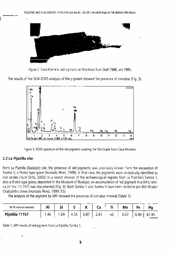
The Early Neol i th ic f l in t mine of Casa Mon te ro , located south-east of the city of Madr id , covers an extension of 3 hectares. Flint was extracted t h rough more t han 4 0 0 0 mine shafts, 9 meter dep th and 1 meter w i d t h mean (Bust i l lo et a l . , 2 0 0 9 ; Capote e t a l . , 2008 ) . The site has been in terpre ted as a resul t o f a short set o f m in ing events most probably occurr ing t h r o u g h o u t one hundred years, be tween 5 3 0 0 and 5 2 0 0 cal BC. Several objects were deposi ted together (un i t 7985 ) probably in a pet i te bundle, more than seven meters d o w n min ing pit number 7 9 8 8 . A m o n g these were t w o small bone too ls and 2 Theodoxus f luviat i l is shells, all coated in ocre, and a f l in t blade coated w i t h a th in f i lm of c innabar (Fig. 2).
4
N E O L I T H I C A N D C H A L C O L I T H I C -V I TO III M I L L E N N I A B C - USE OF C I N N A B A R (HgS) IN THE I B E R I A N P E N I N S U L A
Figure 2. Casa Montero: red pigments on flint blade from Shaft 7988, unit 7985.
The results of the SEM-EDXS analysis of the p igment showed the presence of c innabar (Fig. 3) .
M n \ 3G2-Q1
T
:
| F « M n
I
Ci
M
j
I i I t M 3 / h Ti . Fe Hg H 3 Hg H9
1 1 2 3 4 5 6 Full Scale 726E rts Cursnr D.OB5 11130 cts)
7 8 9 10 11 12 ' i M 1 1 I f 1
13 14 k e V
Figure 3. EDXS spectrum of the red pigment covering the flint blade from Casa Montero.
2.2 La P i jo t i l l a s i t e
From La Pijoti l la (Badajoz) site, the presence of red p igments was previously k n o w n f rom the excavat ion of Tumba 3, a tho los type grave (Hur tado Perez, 1988). In tha t case, the p igments were analyt ical ly ident i f ied as iron oxides (Hunt Ortiz, 2003 ) . In a recent revision of the archaeological register f rom La Pijoti l la's Tumba 1, also a tho los type grave, depos i ted in the Museum of Badajoz, an accumula t ion of red p igmen t in a l i thic lami na (n° inv. 11 .157) was documen ted (Fig. 4 ) . Both Tumba 1 and Tumba 3 have been dated t o pre Bell-Beaker Chalcol i th ic t imes (Hur tado Perez, 1999 : 55) .
The analysis o f the p igmen t by XRF showed the presence of c innabar mineral (Table 1).
W t % (nd=not detected) A l Si S K Ca Ti M n Fe H g
P i jo t i l l a 1 1 1 5 7 1.46 1.69 4 .55 0 .87 2.91 nd 0 .07 0 .49 87 .95
Table 1. XRF results of red pigment from La Pijotilla, Tumba 1.

M . A . H U N T - O R T I Z , S. C O N S U E G R A - R O D R i G U E Z , P. D l A Z DEL R l O - E S P A N O L , V. M . H U R T A D O - P f R E Z & I. M O N T E R O - R U I Z
2 .3 D o l m e n d e M o n t e l i r i o
The Dolmen de Monte l i r io (Casti l leja de Guzman , Sevilla), a large tho los type grave, is located w i t h i n the site of Valencina.The corridor, discovered dur ing huge mechanical survey works carr ied ou t in 1998, had extensive use of red p igments on the slates f o rm ing its internal wal ls .
Later o n , the grave was excavated, con f i rm ing the use of red p igments also in the funerary r i tuals associated w i t h the human remains and grave goods, as we l l as in the internal wal ls of the chamber (Fig. 5). The Monte l i r io do lmen has been da ted in the early stages of the 3 r d m i l lenn ium BC (Vargas Jimenez, 2004 ) . A sample f rom the do lmen , DJ07-32 .C46, taken f rom one of the slates f o rm ing the chamber, ob ta ined in the 2 0 0 7 campa ign , was given by its director, archaeologis t A lvaro Fernandez Flores.
The red p igment , analysed by XRF, conta ined c innabar mineral (Table 2).
W t % ( n d = n o t d e t e c t e d ) Al Si S K Ca Ti M n Fe Hg
Montel i r io DJ07 32.C46 nd 0 .39 8 .09 1.58 1.40 1.07. 0 .05 57 .97 29 .45
Table 2. XRF results of red pigment (DJ07.32.C46) from Montelirio dolmen.
3 . C I N N A B A R M I N E R A L DEPOSITS
As a f irst step in order to de termine the possible or ig in of the archaeological c innabar samples, a prel iminary approach was carr ied ou t on the geographical locat ion and pr incipal characterist ics of the most relevant c innabar deposi ts in southern Iberian Peninsula (Fig. 1).
3.1 U s a g r e m i n e r a l i z a t i o n
Figure 4. La Pijotilla, Tumba 1: red pigment on lithic lamina Cinnabar mineral deposi ts are not k n o w n to exist ^ ^ in the South Portuguese geological zone, and in the Ossa-Morena geological zone the only c innabar deposits are the ones located in the Usagre (Badajoz) area (Calderon, 1910 ; Vazguez Guzman, 1983 ;Tornos and Locutura, 1989; Mapa Meta logenet ico de la Provincia de Badajoz, 2006 ) .
In th is Usagre m ine ra l i za t i on , the exp lo i t a t i on o f Mar igu i t a and Sul tana mines is d o c u m e n t e d since the 1 6 t h century AD. In t he l im i ted f ie ld vis i t carr ied ou t t o col lect minera l samples, ou tc ropp ings of the minera l i za t ion we re observed. A l t h o u g h no clear ev idence of prehis tor ic exp lo i t a t i on was seen in the area (very much a l tered by recent env i r onmen ta l res tora t ion w o r k s ) , a f r a g m e n t of a s tone axe was f o u n d in the surface near one of the mode rn shafts.
3.2 Las A l p u j a r r a s ( T i m a r - C a s t a r a s ) m i n e r a l i z a t i o n
The other area visited w i t h mercury mineral izat ions is located in Las Alpujarras, in the province of Granada, w i t h historical references to min ing f rom, at least, the early 2 0 t h century AD (Calderon, 1910) . The cinnabar mineral i -
6

N E O L I T H I C A N D C H A L C O L I T H I C -V I TO III M I L L E N N I A B C - USE OF C I N N A B A R (HgS) IN THE I B E R I A N P E N I N S U L A
zation extends f rom Castaras to Timar, impregnat ing the calcite, and is considered to be of low content , not over 0 . 5 % Hg (Junta de Andaluc ia , 1986) . Of the mineral samples col lected in the visit to the area, centred in the min ing works located by the ruins of the metal lurgical instal lat ions in the vi l lages of Timar and Castaras, only in one of them was the presence of mercury detected ( 0 . 2 5 % ) . Thus this mineralization was considered not adequate for c innabar pigment product ion (Hunt and Hurtado, in press).
3.3 The A l m a d e n d is t r ic t
The major concentrat ion of cinnabar in the Iberian Peninsula is in A lmaden (Ciudad Real). More than a single mineral izat ion, it is a mineral district composed of diverse deposits (Fig. 6) that , together, fo rm the richest cinnabar min ing area in the wo r l d . The composit ion of the A lmaden mineral is def ined by some authors as simple, w i t h cinnabar as major constituent and pyrite in minor quanti t ies, w i t h occasional chalcopyrite and galena. It is impor tan t to mention that the A lmaden district shows a complex geological history, w i t h cinnabar deposits of di f ferent ages (Vazquez Guzman, 1983) .
Figure 5. Montelirio: detail of the red pigment covering the slates of the chamber (2007 campaign).
The most anc ient ev idence k n o w n , t o date, of c innabar exp lo i ta t i on in A l m a d e n is of the 8 t h century BC (Fernandez Ochoa et a l . , 2 0 0 2 ) . The archaeo log ica l remains s h o w extensive Roman work ings , as documen ted in Las Cuevas, El Entredicho, Nueva Concepc ion and Guadalpera l deposi ts (Domergue, 1987) , w h i c h conf i rms the references of classical au thors (Pliny, XXXII I) .
4. ISOTOPIC RESULTS
In order to establish their possible or igin, the characterised cinnabar minerals excavated in archaeological contexts were submit ted to Lead Isotopes analysis. In its archaeological appl icat ion to provenance studies, this method is considered to be contrasted and reliable, w i t h wel l established extractive and analytical procedures (Rohl and Nee-dham, 1998 ; Hunt Ort iz, 2 0 0 3 ; Santos Za lduegu i et a l , 2 0 0 4 ) .
Simul taneously, to def ine thei r isotopic compos i t i on , the samples of the c innabar mineral deposi ts of Usagre (Badajoz) and Las A lpu jar ras we re also analysed by lead isotope analysis. The results ob ta ined we re added to those avai lab le in the geo-chrono log ica l l i terature referred to the A l m a d e n distr ic t (Jebrak et a l . , 2 0 0 2 ; Higueras et a l . , 2 0 0 5 ) .
Al l selected samples we re analysed by TIMS in the Depar tmen t of Geochrono logy (Univers idad del Pais Vasco). The lead isotopic results are presented in rat ios 208Pb /206Pb , 207Pb /206Pb and 206Pb /204Pb , convent iona l ly used in the archaeometa l lu rg ica l f ie ld , and graphica l ly are s h o w n in the bivar iable plots
7

M . A . H U N T - O R T i Z , S . C O N S U E G R A - R O D R l G U E Z , P. E ) lA2 D E L R | 0 - E S P A N O L , V M . H U R T A D O - P E R E Z & L M O N T E R O RUIZ
Figure 6. Main deposits of the Almaden district (after Jebrak et al., 2002).
208Pb /206Pb Vs. 2 0 7 P b / 2 0 6 P b and 2 0 6 P b / 2 0 4 P b Vs. 207Pb /206Pb , represent ing the four lead isotopic rat ios de f in ing the isotop ic compos i t i on of each of the samples (Hun t Ort iz , 2 0 0 3 ) .
By far, as men t i oned , the most impo r tan t c innabar minera l iza t ion is t h a t of the A l m a d e n distr ict . This m i n era l izat ion has a long t rad i t i on o f geo log ica l research, w h i c h , recently, has also inc luded geo-chrono log ica l studies by means of Lead Isotope analysis. The isotopic data avai lable f rom the A l m a d e n distr ict cor respond to t he deposi ts of Nuevo Entredicho (Jebrak et a l . , 2 0 0 2 ) and El Entredicho, Las Cuevas and A l m a d e n (Higueras et a l . , 2005 ) (Table 3) .
Deposit Reference Pb208/Pb2O6 Pb207/Pb206 Pb206/Pb204 N . Entredicho 2.103530 0.85838 18.352 N. Entredicho 15 I 2.090619 0.84932 18.550 N . Entredicho 18 2.099097 0.85652 18.386 N, Entredicho 22 1 2.094118 0.85425 18.381 M. Entredicho 23 2.090746 _ _0.85198 18.458 Las Cuevas LC-10 j 2.133557 0.86478 18.112 Almaden ALMD-3' 2.103250 0.84945 18.460 Entredicho ETD-1 2.101487 0.85324 J 8 . 3 5 7 _
Entredicho l~~
ETD-2 2.109438 F 0.85629 18.266
Table 3. Lead Isotope results of the Almaden district (after Jebrak et al., 2002; Higueras et al., 2005).
8
N E O L I T H I C A N D C H A L C O L I T H I C -V I TO III M I L L E N N I A B C - USE OF C I N N A B A R (HgS) IN THE I B E R I A N P E N I N S U L A
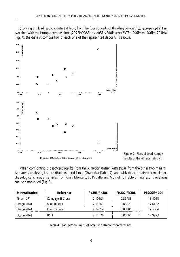
Studying the lead isotopic data avai lab le f r o m the fou r depos i ts of t he A lmaden distr ict , represented in the t w o plots w i t h the isotopic compos i t ions ( 2 0 7 P b / 2 0 6 P b vs. 208Pb /206Pb and 2 0 7 P b / 2 0 6 P b vs. 206Pb/204Pb} (Fig. 7), t he d is t inc t compos i t i on of each one of the represented deposi ts is s h o w n .
I
2 0 8 O.WS
. 0 o • o
• A l m a d e n • E r t r e d i c r i o D L a s C u e v a s O N u e v o E n t r e d r c h o
Figure 7. Plots of Lead Isotope results of the Almaden district.
W h e n con f ron t i ng the isotopic results f rom the A l m a d e n distr ict w i t h those f rom the other t w o minera l ised areas analysed, Usagre (Badajoz) and Timar (Granada) (Table 4) , and w i t h those ob ta ined f rom the archaeological c innabar samples f rom Casa M o n t e r o , La Pi jot i l la and Mon te l i r i o (Table 5}, in terest ing relat ions can be estab l ished {Fig. 8) .
Mineral izat ion Reference Pb208/Pb206 Pb207/Pb206 Pb206/Pb204
Timar (GR) Complejo E! Cruce 2.10801 0.85758 18.2065
Usagre (BA) Mina Rampa 2.13803 0.88020 17.6452
Usagre (BA) Puzo Sultana 2.14354 0.88381 17.5664
Usagre (BA) | US-1 2.11676 0.86666 17.9823
Table 4. Lead Isotope results of Timar and Usagre mineralizations.
9

M A . H U N T - O R T I Z , S. C O N S U E G R A - R O D R l G U E Z , P. D I A Z DEL R t O - E S P A N O L V. M . H U R T A D O P f R E Z & I. M O N T E R O - R U I Z
Archaeological site i Reference Pb208/Pb206 Pb207/Pb206 Pb206/Pb204
Casa Montero (M) 7985.3G-2 2.09672 0.85284 18.3613
La Pijotilla (BA) T-1,11.157 2.07707 0.84703 18.4791
Montelirio (SE) j DJ07 32.C46 2.08951 0.84730 18.4778
Table 5. Lead Isotope results of archaeological cinnabar samples from Casa Montero, La Pijotilla and Montelirio.
W i t h respect t o the c innabar mineral izat ions, in bo th plots (Fig. 8) , a d is t ingu ishab le isotopic compos i t ion o f the A lmaden distr ict w i t h the Usagre minera l iza t ion can be observed. The compos i t ion of the Timar minera l izat ion (as said, considered not t o be su i tab le for p i gmen t p rocurement ) , represented w i t h just one sample, is, in any case, also d is t inguishable f r o m the other t w o minera l izat ions considered.
W h e n con f ron t ing the isotopic compos i t ions of each one of t he archaeologica l c innabar samples and w i t h the c innabar mineral deposi ts (Fig. 8) it is s h o w n , firstly, t ha t the archaeolog ica l samples have a relat ively s imi lar compos i t ion , closer in the case of the samples f r om La Pijot i l la and Monte l i r io . Secondly, the isotopic
o o
0,33 G.S4S 0,35 0 6 5 5 0 ,86 0 ,865 5 .87 0 6 7 5 0 ,38 0 3 8 5 OAS
O O o
« ° 0 O
2 0 7 f W 2 I W P b :
0 64 O.S4G 0 $ 0 0.655 0 3 S 0.6G5 0 .37 0 875 O J S
O A l m H d a n d i s t n c i x U s a j j e m i n t s + 1 irnar m i n e • M u r M e t j r i u A P i p i i i i a * C a s a M o n t e r o ;
Figure 8. Plots of Lead Isotope results of the Almaden district, Usagre and Timar mineralizations and archaeological cinnabar f rom Casa Montero, La Pijotilla and Montel i r io.
10

N E O L I T H I C A N D C H A L C O L I T H I C -V I TO III M I L L E N N I A B C - USF OF C I N N A B A R (HgS) IN THE I B E R I A N P E N I N S U L A
composit ions o f the archaeologica l samples are consistent w i t h the A lmaden distr ict isotopic compos i t ion , but not w i th those of Usagre and Timar mineral izat ions.
5. CONCLUSIONS
Al though this research is in t roductory and more studies and analyses are needed, especial ly in c innabar deposits in nor thern Spain, some relevant conclusions can be made.
In three recently excavated prehistor ic archaeologica l sites the use of c innabar (HgS) as a p igment in a mining (Casa Mon te ro ) and funerary (La Pijoti l la and Monte l i r i o ) contexts have been analyt ical ly documented , reinforcing the impor tance of t he use (and previous min ing) o f this mineral as a p igmen t in the Neol i thic, since the 6th mi l lenn ium BC, and Chalcol i th ic, 3 r d m i l l enn ium BC, periods.
The Lead Isotopic results show tha t the isotopic compos i t ion of the archaeological c innabar samples f rom those sites are consistent w i t h the isotopic compos i t ion of the mineral deposi ts o f the A lmaden distr ict, and are not consistent w i t h the other mineral izat ions analysed. It can be proposed tha t t he or ig in of the archaeological c innabar recovered f rom Casa M o n t e r o (Madr id ) , La Pijoti l la (Badajoz) and Monte l i r io (Sevilla) was the Almaden distr ict .
Being the A lmaden distr ic t the or ig in o f the archaeologica l cinnabar, this p igmen t may have been distr ibuted to the f inal depos i t ion places du r ing the Neol i th ic and Chalcol i th ic per iods th rough long-d is tance exchange ne tworks .
This archaeornetr ic approach has demons t ra ted the appl icabi l i ty of Lead Isotope analysis to provenance studies on c innabar p igments and has a l l owed t o da te the f irst exp lo i ta t ion o f the A lmaden distr ict deposits in the 6 t h m i l lenn ium BC ( 5 . 3 0 0 BC}, more than 4 . 5 0 0 years earl ier t han previously s ta ted.
A C K N O W L E D G E M E N T S
Research carr ied ou t w i t h i n t he Projects " M i n i n g Histor ical Her i tage of A n d a l u s i a " (P06 -02 1 5 9 - H U M ) , Consol ider - lngenio 2 0 1 0 ( C S D 2 0 0 7 - 0 0 0 5 8 ) "Techno log ies fo r the conserva t ion and va lo r isa t ion of Cul tura l Her i tage" and "A rchaeo log ica l Research Project at t he site of Casa M o n t e r o (Mad r i d ) . Product ion and circulat ion of Neo l i th ic f l in t too ls in t he P l a t e a u " (Coope ra t i on A g r e e m e n t of Di reccion Genera! de Pat r imon io Historico de la C o m u n i d a d de M a d r i d , CSIC and Au top i s ta M a d r i d Sur CESA).
REFERENCES
Alimen, M. H. and Steve, M. J. 1977. Prebistoria. Historia Universal Siglo XXI. Madrid, 379 pp. Bustillo, M.A., Castaneda, N., Capote, M., Consuegra, S, Criado, C , Dfaz-del-Rio, P., Orozco, T, Perez-Jimenez, J.L, and
Terradas, X. 2009. Is the Macroscopic Classification of Flint Useful? A Petroachaeological Analysis and Characterization of Flint Raw Materials from the Iberian Neolithic Mine of Casa Montero. Archaeometry, 51(2), 175-196.
Calderdn, S. 1910, LosM'merales deEspana. Junta para Ampliacion de Estudios e Investigaciones Cientfficas, Madrid 2 Vol., 4 1 6 + 516 pp.
Capote, M , Castaneda, N , Consuegra, S., Criado, C , and Diaz-del-Rio, P, 2008, Flint mining in early neolithic Iberia: a preliminary report on 'Casa Montero' (Madrid, Spain). In: P. Allard, F. Bostyn, F. Giligny and J. Lech (eds.), Flint min-
11

M A H U N T O P J I Z , S. C O N S U E G R A - R O D R i G U E Z , P. D l A Z DEL R i O - E S P A N O L , V. M. H U R T A D O - P E R E Z & I. M O N T E R O - R U I Z
ing in prehistoric Europe: interpreting the archaeological records. Papers presented at the 12 , n Annual Conference o' the European Association of Archaeologists, Cracow (Poland). British Archaeological Reports International Series, 1891 Archaeopress, Oxford, 123-137.
Domergue, C. 1987. Catalogue des Mines et Fonderies Antiques de la Peninsule tberique, 2 Vols. Casa de Velasquez, Madrid, 585 pp.
Dominguez Bella, S. and Morata Cespedes, D. 1995. Aplicacion de las tecnicas mineralogicas y petrologicas a la arqueome-tria. Estudio de materiales del dolmen de Alberite (Villamartin, Cadiz). Zepbyrus, XLVIII, 129-142.
Fernandez Ochoa, C, Zarzalejos Prieto, M., Burkhalter Thiebaut, C , Havia Gomez, P. and Esteban Borrajo, 6. 2Q02.Arqueo-mineria del Sector Central de Sierra Morena, Introduccion al estudio del Area Sisaponense. Anejos deArchivo Espafiol de Arqueoiogia, XXVI. CSIC, Madrid. 125 pp.
Gavilan Ceballos, B. and Rafael Penco, J.J. 1999, Analisis de la industria ornamental de la Cueva de los Murcielagos de Zueros (Cordoba). II Congres del Neolitic a la Peninsula Iberica. Saguntum, 2,157-162.
Higueras, P., Munha, J., Oyarzun, R., Tassinari, C.C.G., and Ruiz, I.R. 2005. First lead isotopic data for cinnabar in the Almaden district (Spain): implications for the genesis of the mercury deposits, Mineraiium Deposits, 40 ,115-122.
Hunt Ortiz, M.A. 2003. Prehistoric Mining and Metallurgy in South-West Iberian Peninsula. British Archaeological Reports, International Series, 1188, Archaeopress, Oxford, 418 pp.
Hunt Ortiz, M. A. and Hurtado Perez, V, 2010, Pigmentos de sulfuros de mercurio-cinabrio- en contextos funerarios de epoca calcolitica en el Sur de la Peninsula Iberica: Investigaciones sobre el uso, depositos minerales explotados y redes de distri-bucion a traves de la caracterizacion composicional e isoropica. In: M. a E. Sainz Carrasco, R. Lopez Romero, M. a A. Cano Diaz-Tendero and J. C. Diaz Garcia (eds.), Actas del VIII Congreso Iberico de Atqueometria. Seminario de Arqueoiogia y Etnologia Turolense, 123-132.
Hurtado Perez, V. 1988. Informe sobre las Campahas de Excavaciones en la Pijotilla (Badajoz). Extremadura Arqueologica, I, 35-54.
Hurtado Perez, V. 1999. Los inicios de la complejizacion social y el Campaniforme en Extremadura. SPAL, 8, 4 7 - 8 3 . Inacio, N„ Nocete, F„ Nieto, J.M., Bayona, M. and Abril, D. 2010. Characterization and provenance of red pigment used in
megalithic tombs of south of Portugal. Book of Abstracts, 38th International Symposium on Archaeometry (Tampa, May, 10 14, 2010), University of South Florida, 151.
Jovanovic, B. 1978. The Origins of Metallurgy in South-Eastand Central Europe and Problems of the Earliest Copper Mining. In: Ryan, M. (ed.), The Origins of Metallurgy in Atlantic Europe. Dublin: Stationery Office, 335-343.
Jebrak, M., Higueras, P., Marcoux, E., and Lorenzo, S. 2002. Geology and geochemistry of high-grade, volcanic rock-hosted, mercury mineralization in the Nuevo Entredicho deposit, Almaden district, Spain. Mineraiium Deposits, 37, 421-432.
Lazarich Gonzalez, M. 2007. la Necropolis de Paraje de Monte Bajo (Alcala de los Gazules, Cadiz}. Un acercamiento a! conocimiento de laspracticas funerarias prehistdncas Universidad de Cadiz, 4-15.
Junta de Andalucia 1986. Libro Blanco de la Mineria Andaluza. Consejeria de Economia y Fomento, Junta de Andalucia, Imprenta Ideal. Madrid, 2 Vol.
Mapa Metalogenetico de la Provincia de Badajoz, 2006. Escala 1:200.000, Instituto Geologico y Minero de Espana and Direccion General de Ordenacidn Industrial, Energia y Minas, Junta de Extremadura, 376-377.
Martin Gil, J., Martin Gil, F., Delibes de Castro, G., Zapatero Magdaleno, P and Sarabia Herrero, F.J. 1994. Preserving the Ancients with Vermillion. The Lancet, 344 (8939/8940), 1776-1777.
Martin Gil, 1., Martin Gil, F., Delibes De Castro, G., Zapatero, P. and Sarabia, F.J. 1994a. Neotitico. Uso del Cinabrio. Investigation yCiencia, 219,29-30.
Martin Gil, J., Martin Gil, E, Delibes de Castro, G„ Zapatero Magdaleno, P. and Sarabia, F.J. 1995. The First Known Use of Vermillion. Experientia, 51, 759-61.
Martinez Fernandez, MM., Gavilan Ceballos, B., Barrios Ne/ra, J. and Montealegre Contreras, M. 1999. Materias primas color-
12

N E O L I T H I C A N D C H A L C O L I T H I C VI TO III M I L L E N N I A B C - USE OF C I N N A B A R ( H g S ) IN THE I B E R A N P E N I N S U . A
antes en Murcielagos de Zueros (Cordoba), caracterizacidn y procedencia. II Congres del Neolitic a la Peninsula Iberica, Saguntum Extra, 2,111-116.
Mioc, U.B., Colomban, P.H, Sagon, G., Stojanovic, M. and Rosic, A. 2004. Ochre decor and cinnabar residues in Neolithic pottery from Vinca, Serbia. Journal of Raman Spectroscopy, 35 (10), 843-846.
Obermaier, H. 1919. El Dolmen de Matarrubilla (Sevilla). Comision de Investigaciones Paleontoldgicas y Prehistoricas. Me-moria n° 26. Museo Nacional de Ciencias Naturales (Madrid), 62.
Pliny, 1984. Natural History.W. IX. Loeb Classical Library. Harvard University Press, 34 pp. fiohl, B.M. and Needham, S., 1998. The Circulation of Metal in the British Bronze Age: The Application of Lead Isotope Ana lysis.
British Museum Occasional Paper, 102: 3-11. Santos Zalduegui, J.F., Garcia de Madinabeitia, S., Gil Ibarguchi, J.I. and Palero, F. 2004. A lead isotope database: the Los
Pedroches-Alcudia area (Spain); Implications for archaeometallurgical connections across Southwestern and Southeastern Iberia. Archaeometry, 46(4), 625-634.
Shepherd, R. 1980. Prehistoric Mining and Allied Industries. Academic Press, Londres. Tornos, F. and Locutura, J. 1989. Mineralizaciones epitermales de Hg en Ossa Morena (Usagre, Badajoz). Boletin de la
Sociedad Espahola de Mineralogia, 12, 363-374. Vargas Jimenez, J.M. 2004. Elyacimiento prehistorico de Valencina de la Concepcion (Sevilla). Ayuntamiento de Valeriana
de la Concepcion, 52 pp. Vazquez Guzman, F. 1983. Depdsitos Minerales de Espana. IGME, Madrid, 154 pp. Wagner, G.A. andWeisberger, G. 1988. Antike Edel- und Buntmetallgewinnung auf Thasos. DerAnschnitt, 6, Bochum.
13

J. E. Ortiz, 0 . Puche, I. Rábano and L. F. Mazad iego (eds.) History of Research in Mineral Resources. Cuadernos del M u s e o Geominero , 13. Instituto Geológico y M ine ro de España, Madr id . ISBN 9 7 8 - 8 4 - 7 8 4 0 - 8 5 6 - 6 © Inst i tuto Geo lóg ico y M ine ro de España 2 0 1 1
NOTES O N A N C I E N T M I N I N G IN OTERO DE HERREROS (SEGOVIA, SPAIN)
Mariano Ayarzagüena Sanz and Santiago Valiente Cánovas
Sociedad Española de Histor ia de la A rqueo log ía . [email protected]
Abstrac t . During 2009 and 2010 some members of the "Sociedad Española para la Defensa del Patrimonio Geológico y Minero" (SEDPGYM) and the "Sociedad Española de Historia de la Arqueología" (SEHA) carried out archaeological prospectings in an oíd site in Otero de Herreros (Segovia), where coal, ¡ron and silver were operated. These prospectings have enabled to deter-mine the wal led perimeter of the site, the location of metal lurgical furnaces, which were out of the wal led area, and the location of the oíd doors of the mining village. Moreover, found pottery and road links have been studied as wel l . All this wi l l make it possible to carry out archaeological excavations in 2011 in order to improve our knowledge of the ment ioned site, wh ich w e hope wi l l help to protect it even more.
1. INTRODUCTION
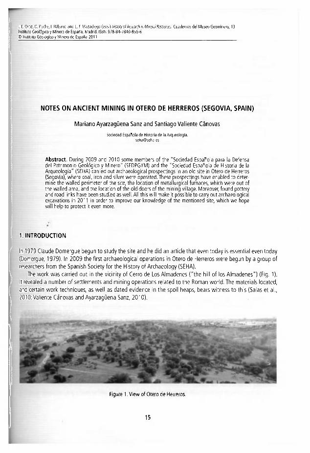
In 1979 Claude Domergue begun to study the site and he did an article that even today is essential even today (Domergue, 1979). In 2009 the first archaeological operations in Otero de Herreros were begun by a group of researchers from the Spanish Society for the History of Archaeology (SEHA).
The work was carried out in the vicinity of Cerro de Los Almadenes ("the hill of los Almadenes") (Fig. 1). It revealed a number of settlements and mining operations related to the Román world. The materials located, and certain work techniques, as well as dated evidence in the spoil heaps, bears witness to this (Salas et al., 2010; Valiente Cánovas and Ayarzagüena Sanz, 2010).
Figure 1. View of Otero de Herreros.
1 5

MARIANO AYARZAGÜrKA SANZ A M ) SANIIAviO VALIENTE CANOVAS
Our main aim is to show the ¡mportance of this area, ¡r te'ms of m ning, since ore historie days, n :he Ro-mán and medieval periods and up to recent and cu"ent times.
Archaeological operations start wi th permits for explcration and operations, giveri by tne Gene'al Di redó-rate of Cultural Heritage of the Minlstry of Culture and Tojrisrr cf t i e Regiera Govenment o* Castilla y Leen.
Considerable coverage is being received from t i e Mjn 'c 'pa l Courc I o ; Otero de Herre-os snd cultural as-sociations of the area, specially the Association of Otero de Here'os, n adsi:¡Dn :o finencial supcor: from :he Caja de Segovia and Segovia Sur.
The first phase of the work is centred on the Ce^o de los Al ir aderes, ir two i rpo r tan t areas: a) :he spoil heap, which has revealed some very interesting wal's exposeo to v ¡ew and b) the s.ag area, where em'ssion levels are observed corresponding to traces of metal urgical operations.
The team of archaeologists wi l l document the rema ns assccisted w i th n i n i r g operations, near the C e r o de los Almadenes, and in the municipality itself.They will receive cor t r ibut 'c rs and ' epo rs from varices com-panies which have worked in the area, and from works about m ning opera tors c-y Diez (2006) and :he oook of routes of the area written by Aragoneses (2007).
For fieldwork, the tools of the Geographical Infornat icn Ser: ce (GIS) wi l be asea ~orthe position'ng of the findings and the sites located.
Depending on the finaridal aid received, different ara yses -.vi11 be proposed oased on tne '.'a*'Oas o-es and slag heaps, complementing those which our partner SIEMCAL5A ñas offsred to cary out. It is expected that there wi l l be several sdentific analyses related to :he so I and tne objeets recovered; ir adeition the'e will be other interdisciplinary teams, to give greater coverage te the archaeological and rn'ning surveys.
2. GENERAL ASPECTS OF THE AREA: GEOGRAPHYAND GEOLOGY
The highlands of the Central System, where Otero de Herreros is locatec, piesent a rich and diverse ecosystem in this area of the province of Segovia. We know they nave been occtpied, and tne exploitation cf ther mineral resources has been going on, since the Chalcolithic era; out t '.VES wi th the Romars that tney began to acgj i re major importance.
Within the municipality of Otero de Herreros i r Segovia are :o be fe une man; varied e eclógica "eatLres (many types of rocks, folds, faults, granite boulders, dikes, veirs, rn'neia ceposits...)_. and 'emrants of niítoric mining activity (walls, duinps, pits, roads, shafts, gallenes, tile anc brlck works, ime kins, quarries ...), a l making up a rich natural and cultural heritage, a ur ique case in the centre of the oen'nsjla.
This rich Geological and mining heritage is the legacyof hun^reds of Til l ions cf years of ceo ocicai history, and about four thousand years of mining, quarrying and m a r u f a c t j r i r g opera to rs (metáis, ce'arnics, s:one...). But as well as being an interesting natural and cu tural he-'tage worthy of preservaron, it is a majo- teuris: and economic resource which, if properly managed and exploitec, car generate '.vea th and cultural activ'ty in Otero de Herreros and its neighbouring district.
3. NATURAL RESOURCES NECESSARY FOR MIN ING EXPLOITATION
There are a number of factors closely linked to mi r ing operations wnich have to be taken into eccount when extracting minerals from the earth.
Once the extentof the area where minerals are iccatec is known, as wel astheir purity, a r d after weiching
1 6
NO'ES ON ANCIENT MINING -N OTERO DE HERREROS ¡SEGOVIA. SPAINl
up the pros and cons ot their extraction, other tacrors are analyzed that aftect the work of mining, ¡ndudmg aaea roads lo the rnost importara locations of settlements for commercial exploitation. Commumcation ¡n prehistoric times is a great unknown. The natural passes betweert mountains, and easier attess by fotdmg rivers may themselves be the guidelines for establishing a series of roads, albeit no more than simple pathways, also füllüwed iri part by migratory animáis iri iheir journeys to pasture areas,
It ¡s the Román roads which have lefttheir clearest mark, although their use m later centunes tías rhanyed part of their routes. In this area in Román times mining operation set out a network ot roads, paved or othorwiso, linkiny major population centres with others irivolved in mineral extraction and manutacturing. In the vlcinlty of the Cerro de los Almadenes can be seen traces and marks of roads, several of which may date írom Román times,
In Roirian times the arca must have bcon abundant iri forests providiny wood for propping up shafts, galleries or other buildinqs, and to feed the fires of the fumares where the ore was smelted, in the forrn of charcoal. It has pmbably been impossible to recover trom this deforestation tor a considerable time. Thus, in ateas near itie Ceno Je los Almadenes we can see areas dew id of vegetaron, such a i in El Boleo and part of the foot of the Sierra del Quintanar. In other areas there has been recent replanting, such as in the Ceno del Estragal and a round the Quejigar creek, In the latter there can be seen severe rock talls and landslides, a sign that the lark of woody vegetation over a poriod, the rcsult oí human action, was associaled with mining activlties.
Woter would be another element necessary to sustain people, animals and for all the operations of mineral extraction, washing, etc., Dams would rnost likely have been ereeted next to the streams and springi which rise in the Sierra de Quintanar and surrounding areas. A systematic survey of the entire area may show signs of dams or water retention systoms, as well as traces ot water pipes.
Togethei with the mining operations, there is evidente of the extraction of stone from quarries equipped to provide the stonc blocks needed to make the masonry used in various architectural works.
4. MINING OPERATIONS A N D HUMAN ACTIVITY IN THE LANDSCAPE OF OTERO DE HERREROS
The mines ot Otero de Herreros are notable for the extraction ot copper, with siqnificant production in the era oí the Ernperor Augustus (Dornergue, 2007: 88),
in addition various minerals have been extiacted in Otero, iíicluding Mnicstone, kaolín, tlay, granito in several quarries in the district, and quart?, as well as copper, in Casammas, iron in the form of nnagnetite and copper with some silver in the Cerro de los Almadenes; and recently tungsten in Navalcubilla (SILMCALSA, M)7).
We know the number of mines in Otero, through a summary prepared by Dr Andrés Díe?, who mentions the mines and locales them predsely on a map. He briefly describes the tungsten workings in the Justo y Pastor mine in the foothllls of the Sierra de Quintanar; the limestone quarries m Canter ucla¡>.; the kaolín quarries in El Cañuelo, and next to the Valdesequilla road; the chalk quarry in La Cruz de Emeterio; day in the former Tejera, and the area known as the Cordillera, on the way to Fuentemilarios; granite or gneiss quarries in the area of f-l Perlroso and i a Cardosa; and quartz quarries near the Ceno de los Almadenes, !n Casaminus he mentions an early twentieth century mine in La Verdina, ot an unknown mineral. He locates the Román copper mines in the whole arca oí the Cerro de los Almadenes, where he mentions different mines; some from the Román period, others Arabic, and shafts and extraction from the seventeenth century (Nuestra Señora de los Remedios, Madre de Dios, San Francisco and St, Catherine ot Siena Mines). Other mining operations correspond to the
1 7

MARIANO AYARZAGÜrKA SANZ AM) SANIIAviO VALIENTE CANOVAS
nineteenth century, such as the Vulcano and La Española Mines; and from the twentieth century there are the Felipa Mine and the pit at La Cañada, and the exploratory drilling of Charter Spain SA. (1970-80) and CISA (1980-90) (Diez, 2006).
4.1 Open-cast mining
The first open-cast tests carried out by the Romans are evidenced by the so-called rafas. These are open trenches following the veins of ore observed on the surface. These rafas may be dug of variable length and depth, according to the outcrops of the veins of ore. The earth and waste materials are dumped in heaps above the trench itself. Many of these same trenches were used as guidelines for establishing subsequent extractions, either by deep mining or open-cast. In other cases, the following of the veins was not deep or good enough, it was not profitable and the trench was left open.
In Otero these trenches can be seen in several areas, where the outcropping veins of mineral are of quartz, to the NW of Cerro de los Almadenes (Fig. 2) and near the stream of La Escoria or Escombrera (translator's note: ñames meaning slag and slag-heap respectively).
When the exploitation of outcrops was of interest, one or more sluicing cuts were made by means of water. In other cases, fire was applied to facilítate the extraction of the ore. In either case, cracks were made in the veins or rocks. At present we have no evidence of the use of these systems in Otero.
The vestiges of open cast mines in Otero are documented in some areas. Open trenches in the ground, following the surface outcrops of ore are located in La Lancha, near the Pedroso stream, on the Mecho estáte, on the way to Tejera (Fig. 3).
In other areas closer to the Cerro de los Almadenes there are located several pits, and a large hollow where the mineral outcrops can be seen in one of the walls (Fig. 4).
4.2 Deep mining ^
Among mining operations which are not carried out in the open are shafts and tunnels. Both may show visible external signs of their existence, even if subsequent extractions have changed them or in many cases caused them to disappear.
Figure 2. Location of Quartz are surface ore. Cióse to the Hill of the Almadenes origin.
Figure 3. Open fo l lowing the veins of ore in la Lancha Creek del Pedroso trenches.
1 8

NO'ES ON ANCIENT MINING -N OTERO DE HERREROS ¡SEGOVIA. SPAINl
They are documented either by waste dumps observed ¡n the vicinity, or by the accumulation of crushed or washed ore ¡n the ¡mmediate surroundings. In Otero and around the Cerro de los Almadenes numerous wells are to be seen, completely blocked with the remains of crushed or washed ore, forming small mounds (Fig. 5).
In other areas at least two shafts and tunnels have been covered to avoid accidents, the dumping of dead animals, or their use for fly-tipping. In this context we cite the mines in the Cerro Estrenal, to the west of the hill and along the hillside. Mineral extraction may have continued up to recent historical periods (Aragón, 2007; Díaz Herrero and Martin Duque, 2006; and evidence from several reports from mining companies). At present some outcrops of ore are visible, and the slagheaps near the entrances are completely blocked up.
• gure 4. Large mirsng pit with creamed ore surface, ih? Almadenes Hill.
Figure 5. Hill of the Almadenes, mining shafts.
In other cases, a small building may be constructed covering up the shaft, thus allowing the installation of a system of wheels or pulleys isolated from the outside. In this sense, there are several remnants of walls around a blocked shaft near the Campanillas path that leads to the formerly uninhabited area of Otero de Herreros. Some of these walls are of masonry, probably of modern or medieval date. There are serious doubts about their chronology.
1 9
MARIANO AYARZAGÜrKA SANZ AM) SANIIAviO VALIENTE CANOVAS
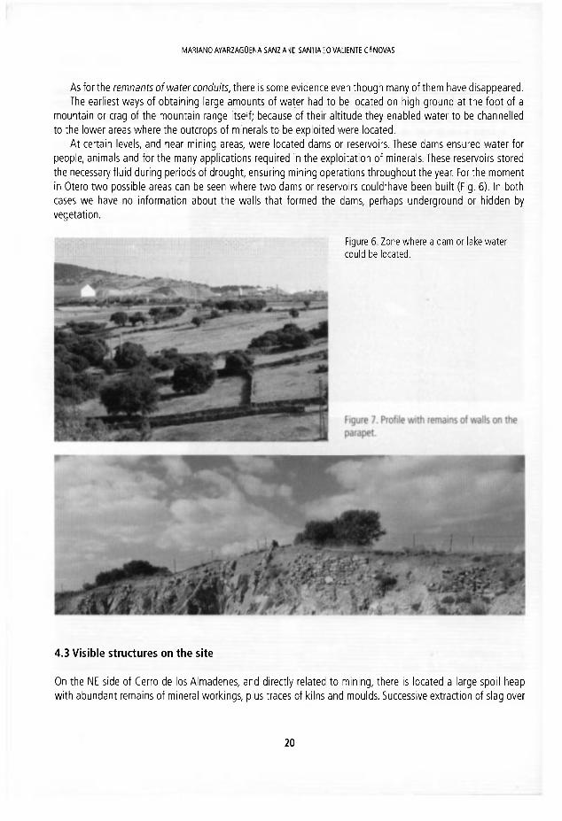
As for the remnantsof water conduits, there ¡s some evidence even though many of them have disappeared. The earliest ways of obtaining large amounts of water had to be located on high ground at the foot of a
mountain or crag of the mountain range ¡tself; because of their altitude they enabled water to be channelled to the lower areas where the outcrops of minerals to be exploited were located.
At certain levels, and near mining areas, were located dams or reservoirs. These dams ensured water for people, anlmals and for the many applications required ¡n the exploitation of minerals. These reservoirs stored the necessary fluid during periods of drought, ensuring mining operations throughout the year. For the moment in Otero two possible areas can be seen where two dams or reservoirs could'have been built (Fig. 6). In both cases we have no information about the walls that formed the dams, perhaps underground or hidden by vegetatlon.
Figure 6. Zone where a dam or lake water could be located.
4.3 Visible structures on the site
On the NE side of Cerro de los Almadenes, and directly related to mining, there is located a large spoil heap with abundant remains of mineral workings, plus traces of kilns and moulds. Successive extraction of slag over
2 0
NO'ES ON ANCIENT MINING -N OTERO DE HERREROS ¡SEGOVIA. SPAINl
the centuries has led to a very ¡nteresting stratigraphy of this hill, which has been reproduced in several of the studies mentioned here.
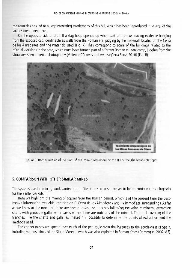
On the opposite side of the hill a slag-heap opened up when part of ¡t broke, leavlng evldence hanglng from the exposed cut, ¡dentiflable as walls from the Román era, judglng by the materials located on the Cerro de los Almadenes and the materials used (Flg. 7). They correspond to some of the bulldings related to the mineral worklngs In the area, which must have formed part of a former Román military camp, judglng from the structures seen in aerial photography (Valiente Cánovas and Ayarzagüena Sanz, 2010) (Fig. 8).
Figure 8. Reconstructlon of the plant of the Román settlement on the HUI of the Almadenes platform.
5. COMPARISON WITH OTHER SIMILAR MINES
The systems used in minlng work carried out In Otero de Herreros have yet to be determined chronologically fo r the earller perlods.
Here we highllght the mining of copper from the Román perlod, which is at the present time the best-known Information avallable, centring on El Cerro de los Almadenes and Its Immedlate surroundlngs. As far as we know at the moment, there are several rafas and trenches following the veins of mineral, extractlon shafts wi th probable galleries, or caves where there are outcrops of the mineral. The total covering of the trenches, like the shafts and galleries, makes it Impossible to determine the points of extraction and the methods used.
The copper mines are spread over much of the península from the Pyrenees to the south-west of Spain, induding varlous mines of the Sierra Morena, which was also exploited in Román times (Domergue, 2007: 87).
2 1

NON S ÜN AMCtFNT MINIMO IM OI I ® Z>F HFRRHOS ; í : : / C V I w . S fA IK j
1. I'o confirm w i th reliable findings the wall strudures and remains of wd Is located en :.op uf ihe spoil-heap of the Cerro de los Almadenes, l o have a so Id msís on wh'ch to es:abl sh n e operations o* consolida tion of the stones and WÜIIS, which are pradítal ly hang'ng in enp'.y spuee.
2. Stratígraphic dean iny of ccr ta in areas of Uie slag o-' thu Cerro de les A rradunes, on the ' ior . f i side.Location and posi t íoning on a map of the d r íe ren t rafas or t re iches, as we l l as :he < r o w i adits,
3. Ihe same for known mines and those which are redisowered. Establ'sh as fa ' as possib o :he w mis mining operations from prehistoric times to the present, j s i r g existing i :erat j re a i d resea-ch, ss well as g c o l o g o l and mining reporls, among other receñí edioMS ¡• i the arca, Sume ernchasis w i I be placed on possible operations in medieval times.
4. To lócate water sources and conduíts, in addition to ary dans or water retair ing insta lations.
Study of the different ancient trarks, induding the western Cañeda Real (traditional d roveV 'CLte) cf Snr'a and livestock paths.
7. CONCLUSIONS
After our inítial contacts w i th the mining operations of Otero de Herreros ano the Cerro de los Almadenes, we have little to offer in the way of results.
The recovery of some ceramic fragmcnls, the docurrenlat ion a-id ca ta log j i rg o ; t-ic ronains; or traces oí ancient mining, seem to corroborate the studies proviced hy C. Dome'gue, exeep: in tne cont¡nu'".y uf nining operations in Román times (Salas et al., 2010).
Insofar as subsidies permit, we have eslablished n terc isdp 'nary units. i i order h r iho work to have h e scientífic content necessary for this type of study.
Similarly, there is a list of analyses to be carried o j t in certair areas of mireral extrsetion a i d prodLCts cxtracted, cuunLinq a l the same time wi th the results Ihat we may oe a ble to ubtair f 'om tlie mii ' ing t o n pe n Íes who have worked there and those that have recently done ceolcg cal sLrveys.
Other analytical studíes would favour a study of soi-s, not to mention :he resuks i i terms of *lora and fauna that the eol ledion of samples could piovide in the a-cas jnder icrutíny. The ma te riáis doc jmented ir straligraphy and in appropriate condítions would be essentiai to enable an analysis of ahsolute dironolngy, wíthín its sequertces otoccupat ion.
It would be interesting to compare the composi t io is o ; tne day of «ve ra l of :he pots (including some of Ierra Siyillata Hispánica) wi th the clay pits in the area of Otero and check for local manufñcturina.
Ihe ultímate goal behínd these operations is the p r e s e n o o n of :he archaeolog cal and Tiin'nq heritage of Otero de Herreros. Wi th this in rnind, all efforts bot ' i suenlifíe ar'd informat ive— should be d'rec:ed to a bigger protection of the site.
All these works are interided to be carried out step by slep, and over a broac :¡rnefrarre, which deperds largely on subsidies and on the issuing of perrnits,
REFERENCES
Aragoneses, J.l'. 700/. / aboros mineras on Otero ríe Hrrrrrm: Libro de Hum. < ¿bnres Mineras. Segnv n Sur, Secovi¿i, 8 pp
n

' • . • l i í i lAV; A'r'A^¿¿Gl.Lt\ A SAKí.ANC SAM1IAGO VALIENTE CÁNOVAS
Di¿¡ Herrero, A. and Martín D jq ie , j.F. ¿'305. raíces del paisaje. Condicionantes geológicos de la Provincia de Segovia. j ' j n t a rie Con r j r i dadss oe í s s r i ' l a y Leon.VahadoliQ, 432 pp.
D o m e x u e . C. 1373. Le c i ss r re r t de cuivre d 'O'sra Se los He le ros (Segovie) et son explotatlon a lepoque romaine. A le memo/re afón tor ro Gs rca y 8eil<OQ. Revuia de ía Universidad Complutense, 8, 116-152,
Jomergi .?. C. ' 9 8 7 . Caratos1 je des .minss er des ¡or.diers de >a Péninsuie Ibérique. Melanges de la Casa de Velázque? I, tv'adrid, 4 6 7 - ^ 5 9 .
D c m e x u e , C. 2007. Leí m.'rves arvífcfues. i.5 producción des métaux aux époques grecque et romaine. Ant iqua e Pícard, Parí;. 240 pp.
Fernández Qchua, C , Zarza e os. f-/., 3 j k h a ' : e r , C Hevic P. and Esteban G. 2002, Arqueominería del sector central de Sierra .Vio.'sr-a1 ín-rrMüCi.'ón a,1 e í f j d i b de.1 ¿rea Suapown-íe. Ane os de Archivo Español de Arqueología XXVI. CS1C Madr id, 125 pü.
Mat as íodr icuez, R. 2005 Ingeniera minera ." imana: la <ed hidráulica de las Médulas (León, España). In: Puche, O, and A y c r z a g j e i c M . (eds). Aí iner iay metalurgia n í s í ó r á s e' i el Sudeste europeo. Sociedad Española para la Defensa del F ü t r i r s n o Geo ógics y v i r e n , Madrid, 275-293.
Péiez '.•lacíís, J. A and Delgado Do~íngLe¿, A 2007 Los metalla de Riotinto en época Jul io-Claudia. In: Pérez Macías, J. A. and De gado D o r i m s i , A. (ees.), ¿a- m í a s tie Hiciinto en época Julio-Claudia. Universidad de Huelva, Huelva, 35 1S2
Salas, >.. Ramos, F. a r d Ayar?ague"ia. N i 2 Í1 Í - . E;*ud'o ae b s materiales del yacimiento minero del Cerro de los Almadenes (Otex- de Herre'os, S se ovia ¡.Algo ras precisiones crorc lócicas. In: Romero Macías, E.M. (ed.). Patrimonio Geológico y .W.'ilí'rr,. ij'na apvesta oor e> desarrollo bcs¡ scslemble. L r ivers ldad de Huelva, Huelva, 634-645,
SIEMCALSA. La rmeda en Castilla y León. Jun:a de Casi lla y León, Valladolid, 402 pp. Val e r t e Cá rov fs 5. ¿nd A y a r a g ü e n ; Sar:.. vi. 2010 . Ed fie os 'omanos relacionados con la minería de Otero de Herreros
(Segovia). IT Mecías, E.'vl. íed.). Fsirirrxmic Geológico y Minero. Una apuesta por el desarrollo local sostemble. Sociedao Español; pa_a a Defensa de P a f i m o m o Geo ógico y Minero, Huelva, 625-633.
Vi las, A. 2005. H i ñ e r a y r e t a urgía de oro en As:u' ias r enana In: Puche, 0, and Ayarzagüena, M. (ed.), Minería y meta-lurgia rrsrór.ras e.n e,! Sudei fe eu'ODeo. Sociedad Esncroia para la Defensa del Patrimonio Geológico y Minero, Madrid, ' 9 7 - 2 1 3 .
2 4

J, F. Ortiz, 0 . Puctip. I. ¡ t toano snd :. F. M a j a d i c g o ( i r i s ¡ Hrflmy of Sí sp«rfi in . « ' . T A ' S?»VIT«. f i a s » r o í CP Mi p r o ( iro-ri iwr:: , H Inst i tuto Geológico y Minero el? Fspana. Madr id , ISBN 97£¡-S<l-7SdO-K l]S-h <£> Instituto Geológico i M i r ? r n de f -spars ?011
DISCOVERY AND MINING HISTORY OF THE "CALAMINE" IN SW SARDINIA (ITALY)
María Eoni
Dipjiliiriei iu S t ie iüe della 'UIIJ. Unlvtiillt di N j p u l i Fedeiiuí II, '-'¡I1 MÜÍCUUII i^ie. 8- SC-1 -,-1 Nupili, M ¡. l y j r ( í u i i r i u - :
Abstract . In year 186S thp irench Belgian engineer lean • yqjí?-n discove'ed the "Cs l sm i re " ores ( larbonate-hosted Zri(Pb) rriinerali/aliüris ot tíie Nom,i.llide ty[;i>) ir s ü ; a i i a l area r:l southwest Sardina, This discovery changed total y r>nth the eco iomic and social 1 fe ir St idinia. cunverLiny iLaly in une of the niaiu p iodu ie is 'or '.lie ¿he (.orrruouiy, l í e t . o r p a r i e i wurk-ng the C.ilamins ores wcro írnnch (Mnlfidano), Bclginn (Vio lie Morraone) n i d t h e i I ta l ia i
(Monteponi). The most important Ca larri i ne n : h 113 aistricts we'e: B L u y é r u - P I a u 5ar Lu, S a i ünnpderto Roueddu, San Giovanni heridas M o d c i / ^ í ^ m n o Pisare a r e M antepon i Arj ru kí,- u . The mairi dif íerente between the deposits was the r iror corteni . Ir. ihe Sjqct j rrL a rea, vie ujiii-mnnlty's lifc and custorns w w o so hnavily ¡nfluenccH hv tlooos of i n o v a t i ó r s re nted to mining activity, that Lhe Luwn was nicknamed (,small París", A l i o n \ i e Mor -e^o ii área, rea i Iqlesab, great amounts of "C.i l<iminr" were discovered befere :he t u i of the certury. a i d a c ' v e y e*-pluited. In the latter urea, the must modem exploitaticn and . 'ncCt ie i : ' ne l hüd iwe re appl ed to the Colamine ore, ranging from several types of f w v i í M . ta the eiectrolyiic p w e v ; . in 1926 was mauyurated dt Monteponi the e leüro lyüt plant lut the low-uidde o• t; T i i i plant, üne o' '.ne uey. in huropc for the time, ronsisted of 168 culis to be ti'lod wi fh t i c acid sclu: on s i d A ) cnthed c sheets, where the ¿ínc predpitated arid wa^ t i i e i stripped. At thh uoint, Sa'üima vvai au e .LÍ nxpnrt / n metal and riot oríly the ore concentróte.
1, INTRODUCTION
The " ta lamines" are carbonate hosted Zn(Pb) ores of the Nonsu fide type.They derive ; ro r i wsatherirg o* pri• mary Zri(Pb)-sulf¡di' concentrations, eventually fullowcd by precipitaiiun oí ncwly 'orned Z i - a-id Pb-Tincrals, when the metakarrylnq solutions are butfered by the carbonate host rocks (I arge, 2 0 C ) .
In 1865 the French Belgian engineer Jcan Eyquem diacovo'ed :he "Calair ine" ü t s in o coasta area oí boüthwett Sardirila, notlh oí the oíd mining villaye uí Flimirinagciiore.Th i diiWJcry ciantied lotüHy üülh the economic and social lite in Sardinia, converting Italy at tne sane time in ene of the rna:n procucers to- the zinc commodity (Sella, 1871}, The nonsulfibc «Calamina" orts weic exploi'.t'J n the biavd unti\ Hit i930t .
lhe SW Sardinia mining district (Hg. 1} is one of the c ass'cal a'eas whoro priT^ry rarhonato-hosted Zr-Pb sulflde ores are capped by a relatlvely thick secondary ox dation zc-ne, corita ning Zn (hycroxy) fa'honatos (smlthsünilL' and hydrozincíte) and silicatos (homimorph'lc) (Bcn et a 2 0 0 3 ) , "he i r incelügy of :hese ores is generally complcx, and comprises not on y the abovc-Tient'orcd ¿ire •nincrslt, bi.t a so cmssi te (PbCOJ1
and anglesite (PbS04), as well as several, tairly exotíc species, dea- to m ñera ccllettors (Sta-a e: al., 19%).

vU'ÍIA LiUN
The nonsulfide ore grado vws highly variable throughüul Lhe t i in'ng disf 'c l , rcngirg f 'om a fevv pertcnl ü :
combined Zri-Pb to more than 30 percent in tne areas where the alterat'on profils -esij'ted in ¿ c á r d e t e re-platemerit of the sulfidts by secondary carbonates.
A thorough uriderstanding of the minerulogy, but abo oí Uie petrographic assodations of the oro a rd host rock has always been a "rmust" in exploration targetirg and feasibility stucies of the Sardic "Ca ¿Tine" deposili, beuiuse of i t i ¡mpacl on processing and Tetsllu'gy, which was steadily evo v i i g th roug i the eichty years of mining hiiiory.
F l u m i n i m a g g i o r e v ^ ^ x í t t Buggerr
Sdñdcsfi¡Nonsülhttei OreDepoátsDistrict
í j
Mines
E Monteponi
0 íanCoi-aniii
(U Carreo Pisano
0 SanfenMÍettc
[ 3 Nebida
IS sSuggerru
1 n - r 2
I D 3 P ^ j f f A
r m 5
. « J i
Ü Í 9
s a i
Hguro 1. (ieologicol stPtrh mnp nf the Iglesiente minirg district, with the lotaticn cf the emplee sites (from 3o i¡ et a. 7(m, mod.), Abbreviotions: 1, overthrust; 2, normil fa.it; 3. Cenozoic, 4. Mesozoic; í>, Variscin g'a lites; 6. Da.aeczoi: (.illochthonous); 7, Ordovicinn to Devonían succession: 8. Iglesias G'ouo (Middle Cairtriíir-Lowíi Cidoviciar); 3. Go.iresa Group (l ower Cambrian); 10. Wcbida Group (lower Cambrón).
J b

DISCOVE^Y ANlJ MINlNC, IIISTORY D F T - f " ( A I A V N; ' IN S/-.k|;rJI;\ ( lA lv )
2, THE "CALAMINE" MINING CENTRES IN SW SARDINIA
2.1 Buggerru-Planu Sartu
After the discovery of the "Calamine" deposita along toe coastal región f r o n S. Nicolb to fv'as.ia, the ...Societé Anonyme des Mines de Malfidano" was founded (Fig. 2A), w i i ch led the way :o a i intersive exploltation of the entice región (Fig, 2B, 2C), (he mineral boom broug-n wilh it ihc ceve o prior:: of a large vi lago tnatsho-tly turned into a town, named Guggerru, whose populatíon reache-c '2 ,000 inhabitant4. at the hegirnint; of t l e twentieth century. The tommumty's lifc and customs were so heavily ¡rifluenced by 'loods of irnovations, t í a : the town was nicknamed „small París". In the same area, also other mining vi lagos wure «tasl isncd, sud' as Pfanu Sartu (1867), on the peneplane southwest of the Bucgeru vil age.
Duriny the big economic boom, which folluwed the f'rst d'sccveries, also the family of the oainter Amedeo Modigliani, which had the concession for produdng cha'coal ir Sardhia, had apalied for a porrnit to exploit the "Calamine" and, having failed, tried to mine them illeaaly, :h s causing many loc¿l problerrs wi lh :he "Societé Malfidano".
Ihe quality of the ore was exceedingly goori, due to the priman/ nature oí tk> lirrestoni'-nostod y j l fdes, which contained high-grade sphaleríte, less galena anc even ess pyrite.
Three plants were suaessiveíy bu i It in Buggerru fo ' prelíminary ore t 'eatment: tne first (1866) was cal ed Büggerru; the second (18/0) took the ñame Lamarmora, a rd the líiird o re f 1890), callod [v'alfidaio, oporated until the final closure of the mine in year 19/9. However, a t tha t t i r re i twas no: possible ta cariyout in Sí rd nia the complete processing, to obtain the zinc metal. For this reason, the erriched, and genera ly a so roaste" ore, was transportod by small boats (Fig. 2D, 2E) to the port cf h e S¿n 3 iot 'ü island xr ther south slo r ig the coast, and from there exported by ship (Hg, 2F) to the smelting cent'es in France and Be'giun.
2.2 San Benedetto-Baueddu
The "Calamine" were oxtensively exploited also in other areas o : SW Ssrdinia. Tho Belgian Vieillo Mcnlaig'ie Company was active around the village of San Benedetto, north of Iclesias a rd in the locality cf Br.ueddu. 'n both deposits the nonsulfide concentrations were Fe rich, due to the high pyrite cor^ísr.t of che primar,1 ore (massive sulfides), and the host rocks exceedingly brittle (''racturoc dol omites). For :h s reason only an openws: mining was ronsidered economic, and of course, wheri rparh'no the water rab e, the exolo'trtion had to be stopped.
2.3 Seddas Moddizzis-San Giovanni-Campo Pisano
At the begiuning of the twentieth century rich Calamine concentra ti O T I S were íourd also r i t'ic sout ' ien fnib of the Iglesias syncline: the major deposits were grouped around the ocality of SecJdss Moddizzis, bu: irtereít no deposits occurred also on the top horizons of Lhe San Giovanm m'nc (better knowr fo ' its argentife'OLS galena), and at Campo Pisano. The latter Calamines were iror-rich, due to trie high content oí pyrite n the priniary ores.
On September 1868 a group of local entrepreneurs and owners con5ti:uted the Compary of S se das Mod-dizzis, whose purpose was to explore a largo territory soulh of Vlouni Sar Giovanrii (Fadca, 1997; Me¿¿diir¡ & Simoncini, 1993), The company got the claím on June 1370, foi an area of arly 177 herares. h the first years, tew miners worked the Calamine rejected in the preced nc works that were conceded only w'th leed anc
2 7

MARIA BONI
Figure 2. A. Letter (July 1879) f rom Mr G. Castanier of the Societé Mal f idano at Buggerru to the Eng. Testore in Iglesias, concerning the advancing stage of the drainage "Gallerie Luden" ; B. The Mal f idano open pit in Buggerru (current status); C. The Planu Sartu open pit on the Buggerru peneplane (current status); D. Buggerru: the "paranze" (small boats) used for t ransport ing the Calamine ore; E. San Pietro island: the "paranze" in the harbour; F. San Pietro island: a ship for Calamine ore transport to European destinations.
j 2 8

ta* , K j¿ ¿ { T i ^k^Á^Hr t l H V J m ^ ' X
^ j g ú ' . i C r ' 1 • W w w É g i i » • JflnP j w J $ J 8 í - , ^ á ^ i ^ j g ú ' . i C r ' 1 • W w w É g i i » > i V f . w V S ^ . . -
1 W w B ^ w ^ m B B W ^ •V "« " \
a S ^ " Í C l J " ' ' -1 ' J V - ^ ^ Í T
«3" Ü y ; • * •' ' '" ' V / ' -Jt ér . ^ I W V ^ H V ^ B é h . '-• jJK^ ÜSW-mLmmk
1 1a
V
t f
+ -0 á w p ^
w
ugure 3. A. View of the Montepom mine at the beginning of the twent ie th century; B. The Cungiaus open pit at the top of the Monteponi hill (current status); C. Underground adits and beginning of the open pit at Cungiaus (1911); D. Monteponi : open pit work ings in the Discarica Moreschini (1905); E. Waste heaps (Discarica Moreschini) at the Monteponi tnine. On the left side the furnaces for Calamine roasting (1905); F. Montepon i mine: the chemical laboratory (1905); G. Monteponi : waste heaps "Fanghi Rossi" (current status); H. Funtanamare: drainage channel Umberto I of the Monteponi mine (current status); I. Monteponi mine: furnaces for calamine roasting (current status).
2 9

MARIA BONI
silver minerals. The turning point coindded wi th the arríval at Seddas, on 1885, of the engineer Asproni, that constructed a riew road fit to the transit of the carts and two calcination furnaces, and obtained in 1930 also the perpetual claím of the mine. During few years more than 100 thousand tons of calamine were extracted at Seddas Moddizzis from the Ciccilloni and Belgrano trenches and from the Santa Barbara gallery. The mineral was processed entireiy locaily, in a plant built in 1893.
Around the fifties, the Company of Monteponi acquired the mine, by the acquisition of the shares of the Asproni heirs, and in the last years of its activity the mine of Seddas Moddizis was induded in the big system that gravitated around the Campo Pisano mining complex.
2.4 Monteponi
Also in the Monteponi area, near the oíd mining town of Iglesias, great amounts of "Calamine" were discovered before the turn of the century, and actively exploited through small adits and quarries, the Santa Barbara shaft and the Is Cungiaus open pit, one of the deepest known in the island (Fig. 3A, 3B). Several waste heaps were accumulated because of the "Calamine" exploitation and treatment (Fig. 3D, 3E). Some of them (the "Fanghi Rossi", Ardau & Runeddu, 2001) (Fig. 3G), one of the marking characteristics of the Iglesias landscape, contain still more than 8% zinc.
The Monteponi Company built also (1870) a small prívate railway to transport the ore mineral to the har-bour village of Porto Vesme. At the same time the difficult problern of draining the lower levels of the mine was solved with the installation of pumps at several depths in the Quintino Sella shaft (1872-1876), and with the construction of the drainage gallery Umberto I (Fig. 3H), which started in 1880 and was terminated in 1889 (4,250 m). The energy supply to Monteponi was partly assured by the acquisition of a lignite mine from the Sulcis basín nearby (Rolandi, 1971).
A preliminary enrichment plant, the "Laveria Calamine" (Fig. 4A), was built at Monteponi with a potential to treat at least hundred tonn/day of bulk ore, followed by another plant at Seddas Moddizzis. Also several other metallurgical plants were set for the calcination of the "Calamine", in vertical and Oxland furnaces to produce ZnO (Fig. 31). In fact, ¡t was economically much more convenient to sell the already roasted "Cala-mine", ¡nstead of the just concentrated ore. In a later stage another calcination plant, which used the Waelz system rotary furnaces, was built to extract zinc from the "Calamine" and from the older tailings, but this system was never a big success.
In 1926 was inaugurateci at Monteponi by the engineer F. Sartori the electrolytic plant for the low-grade ore (mainly the Campo Pisano Calamine), which could not be treated mechanícally (Rolandi, 1971). This plant (Fig. 4B, 4C, 4D), one of the best in Europe for that time, consisted of 168 cells to be filled with the add solu-tion and 20 cathodic sheets, where the zinc precipítated and was then stripped from. In connection with the electrolytic cells, also a plant for the production of sulphuric acid, essential for the electrolytic process, was built at Monteponi in 1928. At this point, Sardinia was able to export Zn metal and not only the ore concéntrate.
All the buildings related to the successive steps of mining activity were perfectly visible (some of them still functionlng) at Monteponi in the fifthies (Fig. 4E), but are currently in a decaying state, if not completely demolished.
Figure 4. A. Monteponi mine: "Laveria Calamine" (dressing plant) (1887), w i th potent ial t o treat 100 tonn/day of bulk ore; B. Monteponi mine: leaching tubs for Calamines before electrolysis (est. 1926); C. Monteponi mine: electrolytic cells (est. 1926); D. Monteponi mine: smelt ing furnaces for Zn cathodes (est. 1926); E. Monteponi mine: general view af the mine and treatment plants (around 1950), Waste heaps in the foreground.
3 0

DISCOVtRY A N D M I N I N G HISTORY OF [HE "CALAMINE" IN SW SARDINIA {ITALY)

MARIA BONI
3. CONCLUSIONS
On the whole, the «Calamina" adventure was comparable for SW Sardinia to the „Gold Rush", which had affected countries like California and Alaska. It enríched a few, changed the lífe of many, and left a stionq mark on the teriitoiy. It was a solid dream that lasted more than hundred years, and allowed this small Mediterránea island ro enter thp industrial revolution like rnost Northern European countries.
REFERENCES
Ardan C, and Runeddu L, 2001, Environmental probloms and industrial arrh.ipology in the Iglesirnto mining dislricL. fíe.nrikxmti Seminario Faculté Sderus Unimulá Cdgtimi Supfjlemenl, 7(2), 91-108.
Boni, M „ Gilg, A., Aversa, G. and Balassone, G. 2003.The "Calamine" of SW Sardinia (Italy): geology, minernlogy and utahlo ¡sotope geochemistry of a supergene Zn rnmeralísation, I conomic (¡cology, 9B(4), B1-/48.
Fadda, A.F. I <597, Siti minutan ¡n Saráigna, Coedisar, Cayliari, 72 pp. Large, D. 2001. The geology of non-sulphide zinc deposits, an oveivíew. Enmetíll, 54 ,264-276 , Mezzolani S. and Símoncini A. 1033, Sardegna da salvare, Paesaggi e architetture delle minierc, t d i t r i r r Archívio hotngraficn
Sardo, Nuoro, 'JV2 pp. Rolandi, G. 1971. La metallurgia ín Sardegna, ¡.'Industrié Míneraiiá Ser. IIXXIII, 17-22, Sella, Q. 1871. Reld7Íone sullc condÍ7Íoni dcll'inrii/strin minorará noH'isob di Snrdcgna. Knlazionc alia commisuone
parlamentare d'inchiesta. Tipografía Eredi Bolla, Firerue, 28G pp. Stara, P., Rizzo. R, and Tanca, G.A. 1996. Iqlesiente-Arburese, miniere e minerali. Ente Minerarío Sarrin I, 738 pp.
3 2

]. E. Oitiz, O Puche, I. Rábano and L. F Ma?adiego ¡«k) Histw/oí Kíwrn M/npra/ I!P™.TPÍ Cnariprroí di1! MUÍFO Oomirwj, 1 i. Instituto Geolóqicn y Minero de España, Madrid. ISBN 97S-R4-/K4Ü-Srj6.6 Q Instituto Geolóqito y Minero de España 7011
SARDINIA'S HISTORICA!. HERITAGE OF MINING EXPLOITATION
Pietrangelo Loru, PatrÍ2Ía Medas, Francesco Muntoni, Luciano Ottellí and Roberto Rlzzo
Kiico üi'oiiiinci'íno Stoiico v Ambientóle dcllj Sjideyiu, Vio Muiiliverdi 1G. 09016 Irjltiiüs. Iialy. fidiKeswjimjnioniíSpaicogeümínerario. Mrdeqoa.it,
rPtjertoriííDifíparcoi] enrmnerario.5srdp13na.it
Abstract. In Sardinia the exploitatlon üf mineral resources hegan in the Farly Neolíthic age (6000 BC), with the mining and processing of obsidían, followed in the late Neolithit períod (3000 BC) by the oxtrattion ot tale (steatite variety). Howwnr, with the developnrierit of brome metaliurgy during the Nuragic age (1200 BC) began the exploitation of metallic ores, in particu-lar r.opper bearing mineials íor the produclion oí hronze. In 1000 BC, the Phoenidans tonk an Ínteres in the Sardininn silver and lead bearing ores. Following this, the Punics also intensely exploited mines in the Iglesiente región (SW Sardinia), where evidente oí their exravations per-sistid unti the middlo nf the XIX Century. In 238 E¡C Sardinia passed under Román rule. The evulved mining and metallurgical lethniques oí Ltie Romans were applird to the Sardinian mines. By the ond of Román rule, mining exploitation was only resumed in the Xlil Century, thanks to Count Uyulirio dolía Gherardesca trom Pisa, who had foundod Villa di (,'hiesa (today Iglesias), a thriving mining city and the second most important metallurgical center of Europe aftei Bohemia. With varyiriy succcss unlil the Industrial Age, in Sardinia mining exploitation increased over tima marking five main periods: the Punk ana Román era, the Judicial and Pisa era, the Aragonese and Spanish era, the Savoy and, finally, Ihal oí Lhc Modern age. With the end of their industria cycle (1980), al i the Sardinian mines saw their role changed, essentíally assumíng sufficient cultural importante today to be detlared "World Heritaye" siLes by UNFSCO.
1.1NTRODUCTION
Several teatures of a naturalista nature characterised and helped to distinguish the mining sites in Sardinia following their dismission from mining. It is easy to understand that issues such as those of a geoiogical aspect (e.g. hosting rocks, metallogenesis and minerogenesis, especially the beauty and perfection of crystallised mi-neral samples of certain types of great valué and museum exhibits), prevail over many others. However, with the condusion of their industrial cycle, which occurred in the 80s of the last century, o I of these abandoned mines have sccn iheir role become one of truc íields of cultural promotion and enhancement of an exiraordinary "Mining Civíllzation" so much so that they have been detlared "World Herítage sites" by UNESCO.
In Sardinia, the almost total dísmission of mining has left important and unusual historical and environmen tal traces of great detall cntompassing documenta records, fadlitics, madiinery, buildinys, ski lis and human valúes within a context of natural landscapes allowing this truly exiraordinary unlque cultural ídentity to be pre-served and transmítled. This is the main task of the Geominíng Historical and Environmental Park of Sardinla, the First oxample of its kind in the woild, one which it took on in 2001, when ihe organisatíon was set up, Sardinía boasts an ancient mining hístory which began almost 8000 years ago, whose mílestones have been described
. B

PIETRANÜLIO 10 í l . PATRIZIA ME DAS, FRANCESCO M Jf-JTONI, L J C I A N O DTTELLI A N D ROBERTO RIZZD
by severalauthors (Márchese ¡n 1862, Baudi di Vesme in 1870, Sella ín 1871, Rolandi ¡n 1948 and Manconi in 1986}. Ihese indicators may be summarised ¡rilo seven main periods ¡ri chronological order: 1} Prehistoria 2) Phoenician-Punic, Román, 4) Judicial and Pisano, 5) Aragonese and Spanish, 6) Savoy, 7) Modern.
2. THE PREHISTORIC PERIOO
Arthaeoloyical studies cartied out to date in Saidinia have explored batk to the Early Neolithic age (about 6000 BC), examining the beginning of the extraction and processing of precious stones, especially obsidian, a vokanic glass which local people bought to make utensris for the home and for work which carne from the rich deposita of the Monte Arel vokanic tumplex (Central Western Sardinia), In lhe Middle Neolithic age (4600 '3300 BC) and recent (3300-2500 BC), stone was also used to make luxurious ítems and ornaments. hiñe and decorativo objeets were made from tale orlginaling írorn the large deposite of Omni (Central Sardinia). In addition, copper and silver were worked for the first time which would chaiacterise lhe Eneolitic Period or lhe so called Copper Age (2500-1800 BC) where lead appea red for the first time.
During the Ancient Bronze Age {1800-1500 BC) at the dawn of Nuragic Civilizatíon, metallurgicai activitles developed around the production of copper, silver and bronze Ítems, both for weapons (e.g. knives arid halch ets) and ornaments (e.g. pins, bracelets and rings). During the Middle Bronze Age (1500-1200 BC), thk activíty was further increased and in the Late Bronze Age (1200-900 BC), ¡n the middle of the Nuragic Civilizatíon, the exploration and exploitatinn of mineral deposite became intense.
The Tuntana Raminosa copper mine (Cíadoni Central Sardinia) played a central role in which rich chalco pyríte mineralised bodies were exploited for at least five centuries by the Nuragic people using the method of fire and throwing cold water onto hot rocks.The copper mineral was separated by soiting and the creating of multen copper metal in the form of ingots. Numerous stone tools were discovered ín the mine. The remains of a miriei beneath a hesp of cascaded rocks cióse to a pile of "rich" ore were also unearthed (the first case of a work accident in the mme). Several foundrics were discovered near Nuraghe along wi lh various forms oí molds for casting of dagger blades together with other arrifaets such as utensils, weapons, lead ingots and dassical bronze figures kriown as "nurayhic bronzes".
Several studies on archeometallurgy and georesources during the Bronze age were recently perforincd (e.g, Bogcmonn et al., 2001; Marras et al., 200/ ; Pinarelli, 2004; Valera et al., 2001, 2003, 2005; Valera and Valera, 2006).
The transition from the l ate Bronze Age to that nf the Iron age (900-SÜ0 BC) was marked by a progresivo ¡riücase in ¡ron artifaets compared to those in bronze, showing matured technical skills in iron-working.
3. THE PHOENICIAN-PUNIC PERIOD
The history of the Sardinian metalliferous deposits, especlally the lead and silver rich ones became Important when around 1000 BC the greot Phoenician sailors showed an interest in the Sardinian ores, espedally silver, with which they made coins which were accepted by olticr natíons for their irade,
Fiyuie 1. Porto Flavia. II was interely üuy into the mt.ks, through its d is i l ia ige yallery and its 9 silos w i th a height of 18 m ead i and annthnr lowcr gallety w i th a strctchüblo r.onveyui belt al luwed lor the loading of ores, arriving f rom the mining aren dircctly into the holds of the mnrehant shlps.
3 4


P I E T R A N G E L O L O R U . P A T R I 7 I A M E Q A ' I . F R A N C E S C O M I J N T Ú N I . L U C I A N O 0 T T F 1 I I A N D R O B E R T O R I 7 7 0
At the time, the Carthaginians also intensely exploited the Iglesiente mines (SW Sardinia), evidence ot whose oxcavations would persist until the mid nineteenth cunLury before being removed from the servicie of modern mining, Numerous archaeological finds Induding stoves, ash and slag melting testify to ¡ron work-ing as a craft from the fifth to the third century BC along wíth lead objeets such as urns, amuléis, votive and symbolic seáis,
4. THE ROMAN PERIOD
In AD 238 Tiberio Sempronio Gracco invaded Sardinia and turned ¡t into a Román province. Mining activity recelved a great boost to offorts to promoLC ihe adoption (AD 269) of silver metal as a monetary base, Written documentation (Dione Cassio) testifies to the request for and the obtaining ¡n AD 47 by the army of Pompeo of a supply of arms and unworked ¡ron. It is estimated that over four centuries, no less than 600,000 t, including at loast 1,000 t of Pb and Ag, were extractcd from Sardinia. This island had the third largest mining province of the Frnpire, after Spain and Britaín. The economic importance achieved by the mining and meta lurgical industries is evidenced by the three cities mentioned in the third century AD in the Itinorarium Aritonini; Plumbaria (S. Antioco Island), a main market for mineials, named "MiAtpa>&r |£ ' T
(Moübodes: Island of lead) by Tolomeo, l-erraria a ñamo derived from the ¡ron mines of Sarrabus (5b Sardinia) and Metaila in the región of Antas (near Fluminimaggiore, SW Sardinia). At that time, mining wasflourishing in the Iglesias-Fluminimaggioro-Guspini trianglo (SW Sardinia), in the area of the Domusnovas mines, wit-nessed by the remains of slag deposits and Román coins from the time of Costantini, Lead was, for the Ro-ma ns, an indispensable element, In fact, it was used for water pipes, pipes and containers of difierent kinds. Roiandi (1948) calculateri that at the end of the first century BC in the subsoii of Rome There were at ieast 5000 1 of lead pipes for drinking water alone and that thrce centuries later, at the time of Costantino, this inaeased to at Ieast 80001, Load was used in the machinery of war, in ammunition, and ín shipbuildlng, the latter to protect ships from fire and the hulls from the destructive bivalve mollusc (Teredo). Roiandi (1948) rcporls that the hulls of two vessels found at the bottom of the Nemi Lake were covered entirely by lead sheets with a thickness of 1 mm width 1 40-1,70 m and held together wi th simple nailing. Even a Román cargo ship submerged in the waters near Spargi Island (Arcipelago de La Maddaiena) and those along the Liguilan coast of Albenga and Turusia had hulls coated with this metal. The lead used was also of a hlgh quality, having a grade of 99.88%, wi th impuritie1; ronsisting of copper (75g/t) and silver (3 lg / t ) .A t the time oí resurnption of Pisan thirteenth century metallurgical, the residual slag melting of galena was estimated to be 350,000 l, Considering over the centuries all the material LhaL had spilled into rivers, the sea and into the streets, the scale of the Román production of Pb and Ag, it is estimated, produced at Ieast 1 mllllon t of waste. The techniques of extraction of minerals used by the Romans consisted of numerous parallel and deep wdls. These narrow tunncls, often barely fit for use, were interconnccted and fol lowcd the direction of the mineralised rnasses (columns or lodes} of argentiferous galena. Simple tools such as awls and hammers were used for excavation and workers consisled predominanlly of slaves or prisoners of war or those con-demned "ad metalla" for political and religious reasons ¡n relation to which two popes are mentioned.The decline ot the Román Empire also marked o move away from mining and metallurgy. The ediets of emperors Gra7iano Valente (AD 369) andValentiniano (AD 378) ronstitute the last documents on mining in Sardinia. After AD 460, wi th the invasión of the Vandals, all mining seems shvouded in silente.
3 6

SARDINIA'S HISTORICAi HERITAGE OF MINING EXPIOIIATIGN
5. THE JUDICIAL AND PISA PERIOD
In the Early Middle Ages, Sardinía suffered the descent of the bsrbarians from northern Europe. In AD 456 carne the Vandals with King Genserico whoruled unti lAD 534, date of theof f idal entry of Sardinia into the Byzantine Empire. Mining did not prosper during this period. Some reference is made to a minímum indirect production of silver with which precious silver votive offerings were made and donated to the Pope by the Bishop of Cagliari (Azuni, 1802}. The metallurgical activity was completely suspended due to the attacks carried out by Islamic warriors (Saracens) which tasted about three centuries from AD 705 until they were finally annihilated in 1016 by the Sardinían people both on the ground and by a fleet of Ships from Pisa and Genoa. Towards the end of the millennium, thanks to a network of courageous merchants, largely made up of Jews, trade links with the ports of the Mediterranean were resumed leading to a cultural renaissance and promoting a resumptlon of mining, an already thriving activity in Tuscany in Central Europe. From this period onwards, Sardinia was geographically divided into four judgeships: Cagliari, Arbórea, Torres and Gallura with constant ¡nterference from local governments by the maritime republics of Genoa and Pisa. In 1186, Pisa occupied the Judgeship of Cagliari, divided between the Capraia, Visconti and Donoratico Counts. The latter was awarded SW Sardinia. To Count Gherardo della Gherardesca was given the Sulcis región and to Count Ugolino della Gherardesca the Iglesiente región (at the time known as the Argentaría del Sigerro). Thanks to the initiative of Ugolino (quoted in Dante Alighieri's Divine Comedy in the 33rd canto) and his sons Lotto and Guelfo, the great awakening of the Sardinian mine production commenced together with the emergence of "Villa di Chiesa", the present cíty of Iglesias, that rose cióse to the rich metalliferous hills.
During the 70 years of Donoratico's Government, Villa di Chiesa (Iglesias) developed an order, becoming a mining, administrative and legislative hub, with a mayor and magistrates who administered both ordinary ¡ustice and the aspect of mining. Weights and standard measures were kept in the city and used by officials in the service of Ugolino Count of Donoratico. Villa di Chiesa had its own mint which struck coins of silver or an alloy of cop per-sil ver-lea d, metáis mined in the district. Major mining development brought with ¡t the creation of specific laws that were united in one of the oldest mining codes of Europe known as the "Breve di Villa di Chiesa," the only document that was saved by fire which destroyed Iglesias in 1354. Even today, the Breve di Villa di Chiesa remains a splendid example of civil as well as mining regulations. In about twenty years Iglesias had become the second most important metallurgical center of Europe after Bohemia. At that time the mines were called "fosse (pits)" and there were over a hundred scattered around the limestone mountalns of Iglesias. The technique of excavation of Pisa was characterised by horizontal tunnels, as well as several useable wells, using animal power for the extraction of baskets full of rocks, and fire to break up the rock to be excavated. Once the ore had been extracted, waste rock was shattered using heavy hammers and the ore was taken to common foundries. A dozen were foundries known as "piazza da forno". All these activities provided jobs for over 8,000 people, with the exception of shopkeepers, artisans, notaries, various officials and troops.To escape the fíghting between Pisa and Genoa, the Donoratico became independent from Pisa, but then were defeated by the combined forces of Pisa and Arbórea. In 1297 Pope Boniface VIII made a gift of Sardinia to the King of Aragón James II.
6. ARAGON ESE-SPANI5H PERIOD
TheAragonese ¡mposed new feudal laws and encouraged the inclusión of entrusted people of the government in the rich mining town of Iglesias which soon began to decline along with mining, In 1302, amendments
3 7
P I E T R A N G E L O L O R U , P A T R I Z I A M E D A S , F R A N C E S C O M U N T O M , L U C I A N O O T T E L Ü A N O R O B E R T O R I Z Z O
to the Breve di Villa di Chiesa were insufficient to prevent the progressive decline of mining due to the over-production of gold and silver from the rich fields of the new American territories which had been conquered by Spain. Furthermore, trade silver was no longer free as it had to be sold to the Royal Court of Spain which introduced the principie of separation of ownership of the ground and underground, the latter for which state law would demand a prívate form of rent. The prolific recurrent outbreaks of plague, which decimated the population, also contributed to the decline of mining with reports of unsuccessful ventures by a number of individuáis between 1472 and 1507.
It ¡s only after 1603 that other reports of mining activity carne to light. Among the other various ventures that followed can be recalled that of Cagliari Martlno Esquirro who in 1614 obtained a thirty-year concession for the exploration and exploitation of mines in Sulds-lglesiente (SW Sardinia).
7. THE SAVOY PERIOD
With a brief períod of Austrian occupation (1708-1717), with the 1718 Treaty of London, Sardinia was ceded to Duke Amedeo II, Savoy Prince of Piedmont. The Savoy consented to the exploitation of Sardinian mineral resources, considered state property. In 1721, a twenty-year exploitation of Sardinian mines and foundries was granted to Pietro Nieddu and Stefano Durante wi th the requirementof a fee of 6% on the obtained result. Their company resumed exploitation of the rich Monteponi mine (Iglesias) which was extended to the neighboring area of the Fluminese región. The results were so satisfactory that a foundry was built cióse to Iglesias and two others cióse to Fluminimaggiore. In 1741 a thirty-year concession was granted to the Anglo-Scandinavian Society founded by Cari Gustav Mandel, Cónsul of Sweden in Cagliari who entrusted management of the work to the Germán Chrlstian Boesen who employed Germán speciallsts to Improve productivity with new techni-ques and extractive metallurgy. A lead and silver foundry was built In Villacldro and the use of landmínes in the excavation of the Monteponi mine was introduced, saving effort and reducing costs. Following Mandel's death in 1759, the knight Pietro Belly took over management of the Sardinian mines in 1762 but with littie success and who left us a description of the Vil acidro foundry, mining operations and organisation of Mandel.
A turning point carne in 1829 with the Sardinian engineer F. Mameli, who was commissioned by the Pied-montese government to inspect and evalúate the consistency of the Sardinian mines. He contributed to the improvement of laws inslsting that Savoy laws should be extended to the island too but he died prematurely, two years before his dream was realised. In 1848 the Piedmont Mining Law of 1840 became operational which sanctloned a clear distinction between underground, the exclusive property of the state, and the overground property of the citizen for which the latter was entitled to compensation for any damage, along with the in-troduction of rules for prospecting. This led to the most prosperous period of mining in Sardinia. Many of the most irnportant Sardinian mines were put into operation during these years as evidenced by over 400 mine ñames on the map drawn up by Sella (1871). Among technical irinovatiori can be recalled the intensive use of explosive during exploitation, the first narrow-gauge railways and the first hand winches, the reduction tunnels which facilitated the process of mine drainage and the first washery for the enrichment of mlxed poor mlnerals.
8. THE MODERN PERIOD
Initially, the mineral trade was aimed at foundries in Marseilles and later also at the markets of Northern France, England and finally in Belgium where better prices were obtained. The main mineral exploration and production
3 8

SAROINIA'S HISTORICA!. HEP.ITAúE Of MINING EXPlOlTATlON
Involved argentiferous galena from Monteponi (Iglesias), easily fused, and the nearby mines rlch In Cambrlan limestone, Minerals extracted from the Masua, Nebida, Malfidano and Acquaresl mines were difficult to seli due to the presence of zinc mineral?, (calamine). The pon of Carloforte (San Pietro Island, SW Sardinia) received big ships of the high seas from internacional destinations. Instead tranb.it from the ore mines at Domusnovas Vallermosa arrlved at the port of Cagliari. There were 88 mines and 106 mineral excavatlons for argentiferous galena, 1 iron mine, ? zinc mine; and 2 copper mines in the Iglesias distrid. Advances in mineral enrichment brought Sardinia to the vanguard of the industry. Manual washeries increased (tip to 15 at Monteponi) whurc rninerals was crushed by hand and produets separated in the flrst (80% Pb), second (60% Pb) and thlrd qua-llty. lhe latter was then washed in six Sardinian sieves and in Turn enriched in the first and second quality. To expioit the large quantitíes of unused tout-venant low concentraron (15-20% Pb) acrumulated in the yards, a numbtT of mechanical washeries were built, In 1868, Nobel invented dynamite and gelatinised it in 187b, also inventlng capsule rriggers, In 1880, compressed air drilling was introduced with a reduction in costs of 15% for every meter of tunnel length, In addition to galena argentiferous, due to the efforts of the Belglan englnoer Eyqucm, tho search for and exploilatiori of large deposits of Calaminarian contained wlthin the Cambrian limestone was developed in Igiesiente.
In 1887, a washery named "calamine" designed by Eng, E. Ferraris was brought into operation.The problem of fine material was resolved Iri 1898 with the commissioning of Ferraris' "swinging table" that made him fa-mous throughout the world and is still irreplaceable in r.ertain applications even in ils modern versión, With these technical innovations occurred the first major market crisis of Pb and Zn in the late 1800's due to the Invasión on the world market of Australian metal, In 1889 the Gallería Principe Umberto was opened, surfacing at the beach ot Funtanamare, drllled b km ¡nto the nearby mountains which solved the sorious problem of mine drainage water that flowed in large quantitíes from the slopes ot the Iglesiente Basin, thus lowerlng the hydrostatic level another 70 m and ailowirig the exploilatiori of large new areas of deposits and providing work for many dec-ades. In several mines, there was a spread of electririty, mechanical drilling and development of elednc ignitlon of the drill. In 1892, on Malfldano railroad, steam traction took the place of the animal, In early 1900, there was almost complete olectriflcation of the mines and in 190/1 carne the first eledric railway in Sardinia which carried ore from the Acquaresl mine to the port of Cala Domestica (SW Sardinia). Calrlum carbide, cheaper lamps and rüiriforced concrete for the coatirig of wells and tunnels were introduced. Extraction machines were signiflcantly enhanced and cables were replaced with steel, The Huritington-Heberlein converter for galena desulfurlsation was widespread and drilling with compressed air was finally adopted along with the introduction of rolary hammers. In the ambit of mineral enrichment, a radical innovation was the genesis ot the Industrial proress of flotation. This process with all its variants adually conlributed to the resumption of Sardinian mining which had been unrlermined by falllng metal prir.es due to excessive USA production and World War I, Moreover, the use of shovels for mining was Introduced, electric traction extended underground to Monteponi which further lowered the water level by 15 m and at Campo Pisaría an eledrolytic system for the treatment of ferruginous calamine was designed and built, uníque at the time, that began exploitation of the ore, To reduce the cosí und time of shlpping of the ore and to elimínate the iaborious business of transporting ore, small Latín saiihoats called "bilanr.elle" and individual mines serviced the port of Carloforte, place of berthing of large ships. In 1922, the englneer C. Vecelli designed and then created in 1924 Porto Fiavia, a feat of mining engineering till then unprecedented In the world. In the heart of the di f f limestone were duq 9x18 m tall storage silos connected by an extraction tunnel above for Lhe storage of mineral extracted. A second lower tunnel equipped with a conveyor belt allowed the moving of the ore from the bins directly onto the hoids of large ships (Flg, 1).
Further Innovation took place to overcome the global economic. crisis of 1929, which began on lhe streets and in many smaíl and médium eriterprises leadirig to the closure of the mines in their tens. Ihis
3 9
PIETRANGELO LORU, PATRlZIA MEDAS, FRANCESCO MUr-JONI, . JClAh.C : T T i L - rlOEEFTÜ -¡ ZZO
carne in the form, in 1932, of the San Gavino fourdry wnich was b r o u g i : into ope-ation, built by the two most important Monteponi and Montevecchio minina companies. The great ef fort of tednnka1 reorganisa-t ion together w i th a set of social factors, mean! that Sarcinlan mining prospered unti l the outbreak of II World War when it suffered a sudden general collapse ir 1943 and an a i most tota ' shutdcwn of production. At the end of the conflict there was a new mining recove,'y which i&stec about a cecade. Mi reí a i extraction was addressed w i th intensive criteria. Wi th refinec metallurgic techr iques end especie, y the new system of organisation, it was possible to extract areas of deposits f r o n tower veins, leaaing to a new loncer íife span of this industry, Already, immediately after World War II, there was a rev'val of che mining i rdust 'y w i th an increase of extraction of lead and zinc (of great importance) aeded to which, in t ne ro ' c -w ing years, there was an intensification also of the mining of arsenic (Baccu Loco Mrne), antimony {Villasaito Mines), ccpper (Funtana Raminosa, Sa Duchessa mines) and ¡ron (Canag a, Sa i Leone M'nes). There was subsequerv: , ar associated production of a number of important non-metallic n d i s t r ' a l nñnerals such as :a'c, barite, "'iLorite, kaolin and refractory clays. In parallel, there developed a r Important sub-bituminous coal proúuct ior ' rom very rich Sulcis ore deposits (SW Sardinia) which fiourished especially dur i rg the regime cf autarky, machina 1 mil i ion t annually.
Among the many technological innovatlons of the period are mentioned ir particu a- the varic-us rre'hods of flotatlon of oxidised zinc mineral (calamine), apolied for exaxple successfu-ly for the first t i r re ever in 1950 in the San Giovanni mine (Iglesias), al lowing the extraction of considerable quantit.es in tonnes of ore feom lower veins and the reworking of previously mined veins. Also, T o n 1960, the design a r d use ir ot.ner rrines of the "autovagone Montevecchio" and water deepen-ng (-100 m} in tne Iglesias basin created in:ta"y the 'a.-gest and most important water drainage plant of Europe. In the ea:,y 196Gs, the fall in pnces of lead ene zinc led to a crisis in the industry, As a result, the more expensive mires were abardoned with a fall of about 2,000 work units. Major Sardinian mining companies (i.e., M o r a p o n . and Mo^teveccnio} were fused together, ' .wh an establlshed network of tunnels connectíng underground n h e s in the bes ien te oasin ir order to merge all the production of raw material ( 60001 per day) wi th the rnedern and centralsed en' chment plant of Campo Pisano, wi th the realisation in Monteponi of a Weelz oven ror t rea t i i g oxidised zinc a r d the Monteponi e'ec-trolytic plant expansión. To avoid the redundaney o f m a r : T in ing workers, Mere was irten;ention in :he ouolic sector wi th the drawing up of appropriate management píans for t r e Saraniar metaVi'erous mines, the f n a l dosing of which was only delayed by about a decade, due to socal factors, namely the cont i ruing depletion of deposits that, despite the improvement in market pnces of these metáis, prodiced losses that led to the divestiture of assets. One by one, upon their closure, :he rnir.es were acquired by vari ous companies who wou.d then oversee their management.
REFERENCES
Azuní A D. 1802. Historie Géograpbique, politique etnatureüe de la Sardaigrie. Pars, np. Baudi di Vesme C. 1870. Dell'lndustria delle Miniere riel territorio oí' Villa di Chiesa r.n SarJepa rreí primi lempi úeüa ete/JV-
nazione aragonese. Stamperia Reale, Torino, 288 pp. Begemann F., Schmitt-Strecker S„ Pernicka E. and Lo Scniavo F. 2031. C heñí ta l c o m o o s d o r a r d .ead isoropy o ; coDpe- and
Bronze f rom Nuragic Sardinia. Furopean Journal of A'chaeology, 4 (1), ¿3-SS. Manconi F, 1986, Le Miniere e i Minatori della Sardegna. Consigno Regionale della sardegna, .Wa.no, 236 pp. Márchese f . 1862. Cerno sulle ricchezze minerali dell'lsoia di Sardegna, ad imelUgenza delle collezmi del mineral! utiii che
si rinvengono nei suoi terreni. Timón, Cagliari, 97 pp.
4 0
SARDINIA5 HISTORICA!. HERirAGL 01 MINING LXPL0ITA1 ION
Marras Cí, Valora P Ci. and Valora R.G. 2007. Metal Supply, and Domestic Metal Trade in Nuragic Sardinia. Archaeometallur gyin Europa 2007, Aquikis 17-21 Giugno 2007, CD-ROM.
Pinarelli L, 2004, Lead isotope chararterbarion of copper ¡rgots from Sardinia (Italy): inferences or their oiigins. Proceed-ings of the 10,h Inromational Congrpss, Thcssaloniki, april 2004, Sulletm of the Geological Society of Greece, 36, 1173-1180.
Rolandi G, 1948 Not¡7¡c wll'indtiitría del piornbn o dcllo unco In Italia- Monievecchio, Súdela Italiana del Piombo e del lo Zincn, Milano, 326 pp.
Rolandi G. 1974. ta metallurgia In Sardegna. L'lndustria Minerarla Td., raon?a, 3/9 pp.. Sella Q 18/1. Sullc cnndfrinni dcH'induHria mineraria in Sardegna. Bolla, Fueiue, 319 pp. Valera R.G., Valera P. G. and Lo Schiavo F. 2001. Lead in Nuragic Sardinia: Ores, Isotopy, and Archaeology. In: Barthclheím
M„ Perriicka E. y Krause R. (ed.), Die Anfange der Metaliurgie in der Alten Wcltñhc tirginning of Mctallurgy in th<; oíd Woild. ArchÉometiie-Freiberg Torschungen ?nr Altortiirnswissonschaft, Band 1,359-377.
Valera R. G„ Valora l'.G. and Rivolrlini A. 2003. The Sardmian Mineral Deposits in the Bronze Age. International Confcrcncc Arcbaeomnültuigy in Europe, 24-26 Setiembre, Milano. [d.Associazione Italiana di Metalurgia, Milano, Vnl. 7, 12/-136.
Valora R.G., Valora l'.ü. and Rivuldirii A. 2005. Sardmian ore deposits and metáis in the Brome Age. In: lo Schinvo F„ Giumlia-Mair A., Valera R. and Sanna U, (eds.), Archaeometallurgy in Sardinia. Fditions Monique Morgoil, Muntagnac, Monoqraphies Instrumentum, 30,43 8/.
Valora R.G. and Valera RG. 2006. Georesources in Bronze Age-Sardinia. Instrumentum, 23,37 39. Vecelli C. 1925.1 Nuovi impianti per il carico dei minerali a Portn Havia prosso la miniera di Matua. ResocontiAuociMiotie
Mineraria Sarda, 4, 7 13,


I. F Ot ¡7 , 0 . í 'urhP, I B i l i a r i o . w ! I f. (wl '>) t h \ " \< ¡ f t p m r r , m M i w . i l ftpttuiw. r i M d n m m t l r t M n w > C < t > M r w y ^ 1 ' M í M i i l n U n l M I r o V MIIWTFT ÍLOKFLÍRM, MÍ Í I Í I . 1 ISHNFLFLWI^/FKIWISFRFI í ) l i m i t i c n f i í o l A i l i r o y Wm»rn fie H p f l i v . ! ( ] 11
MINING AND MINERALS TRADE ON THE SILK ROAD TO THE ANCIENT LITERARY SOURCES:
2 BC TO 10 AD CENTURIES
David Sevillano-López' and F. Javier González''
' HiWirMti I df/'dí'Vffifl /, WII14 Mldnd, rl',f'villrini-ilopc."ítli)iT'i,!|¡l rni : íjíOlúgiíJl Sutvíy of I Ú Í N (KJMLJ IÜOÍ H M Í 2J, JBUCJ [v'JCLND i|Min. (,.goii¿iil(j¿@ÍBME.ET
A b s t r a e ! The commercial relations between commuei t ies across the [ u r o Asían cont ínent have exísted since prehistoric t imes. The period comprised between 2 EC and 10 AO ten tunes is esperíal ly ¡rnportant hricnu^r the r ommer r i a l eontoets were prometed hy the existence of twO 019 ernpires- n the OppOSite extremes of the cont ínent : iri ihe beu innmy, Román Empire .inri Han Dynasty Chinese l-rnpire, and ater, the By?antíne Kmpiro and the lang Dynasty C'hi nese Empire. The mercantí le routes establíshed between these big empires were thei i cultural bnso, tn rhno lng ica l and commercia l development , nnd for intnrmndinry región1; as the Persian and the Omeya-Abbassi empíres. Two types of commercia i routes were establíshed between them; the over lanr i and the marít ime, A l though "Silk l i o a d " is the popular ñame for these commerda l routes- ín relat ion to the trade of this fabnc - min ing aieas, p ioduced mineials and thelr der ivat ivo producís were impor tanf in the con f i gu ra ron of this roari. Iho ancient Greco Latín and Chínese líterary sources tel l us about min ing and mineral produets. The mineials and thelr denvatíve produets objeet of t rade ran he elassítíed as common use goods (e.g., steel, copper, lead and t in) and prestíge use goods (e.g., gold, silver, gems, giass and asbestos) in relat ion w i t h their social uses ín ant iqui ty . M in ing p r o d u a i o n and" trade centers of this activity, could have condi t íoned the route of this commerda l road, as technoloqic and cultural trans-missíün between the East and the WesL.
1. INTRODUCTION
Ihe period between 2 BC to 10 Aü is interpreted as the most splendid time in the commercial road commu-nicatíon from the East to the West. This splendor could be at this time, because of the Silk Road's ends, where there were two great centralized empires. i.e. Román Empire and Han Dynssty Empire, Byzaniine Empire and Tang Dynasty Empire. This commercial exchange was made previously ín Eurasia.
Thanks Lo archaeology and sorrie anderit texts, we know about these malerials goods exchange among these people. We can find only one dífference since ') BC; the trade was with an intense diploinatic activity, which ín the first moment was guíded by Han dynasty (206 BC. -220 AD) in China. Ihe only precedent in this diplomatíc activity was Alexarider the Great's empire, which joined India and Greece together (Boulnois, 2004).
It is vory diffícult to apply only one ñame to the commercial trade routes in tho ancient Eurasia, but the ñame of Silk Koad ís the most wídespread, coined by l-erdínand von Klchthofen ¡n s. XIX (Rlchthofen, 18 / / ) . But the term "Silk Road" isn't very precise because there were several routes not only one, overland and maritíme.
4 3

DAVID SEVILLANO-LÓPEZ AND F. JAVIER GONZÁLEZ
Abide from that, the ríame gives us a wrong idea about what products wereexchanged.We can classify the Silk Road producís, i.e. materials (silk, medicamento, spices, wood, iron, copper, gunpowder, goms...), technoloqy (compass) and idealogy (different religions). Also, we can read andent accounts about torced people move monis and slave Lrade, i.e. jugglers oí Likan (Román Orienl) arrived a t the Han Dynasty court (Boulnois, 2004; SJ.123.92).
The scholars of Silk Road have researched a lot in many ways, but we can find that mining, mineral trade and tho importanco in economic and cultural development in Eurasia are not been studied enough. We showed before that silk wasn't tho only product marketod airiong llie different people on "Silk Route", and by con-trast minerals were very important producís in carried out transactions. Minerals carried idea1^ and associated Technologies, extended arnorig different cultures. In s. I BC, the first in describing the Road's itineraries was the Chínese account. íhís account is Shíji of Sima Oían, who tells us brlefly about mineral rosources of some kingdoms (SJ, 123.92),That way the mineral resources trade and its associate technologies have been uninter rupíed sínce before Common Era.
The period we wíll study in this artide, is about all commerdal and diplornatic exchanges. The minerals were very important strategic goods, as the government tried to control its extraction in centralized empíres. An example of this minora! production's control is China, iri s. 1 BC, where it was necessary to state made a monopoly of productíon and marketing of salt and steel. This monopoly could be possible thanks to the management of mines and furnace.
This monopoly was rcpoated during Tang dynasty (618-907), several centuríes after Han Dynasty's fall. In the Román Empire we musí remínd the restriclive laws over silk trade, the Román Senate issued in several times to check the precious metal flight when Oriental producís Import were paíd (Boulnois, 2004).
Thanks to textual sourcos we can ostablish thal in s. 7 RC the diplornatic and trade relations were rnanoged from Han Dynasty to Eurasia. Ihe precursor of diplornatic relations was emperotWudi of Han Dynasty (141-87 BC.), who — i n 138 BC— sent an embassy lo Central Asia with Zang Qían as ambassador to find alíies to harass Xlongnu kingdom in its rearguard (Boulnois, 2004), Shiji related to the Zhang Qian's periplus, describes several kingdoms of Central Asia: Yuwhi kingdom, in Afghanistan, and others counti les in extreme West. These kingdoiris were unknown to Chínese, and in his account, Zhang Qian described their costumes and producís, and others minerals.
The Zhang Qian's embassy was the first of a long list. In Hou Hanshu (HHS), tells us that in 166 AD "The king of Da Qin, Andong [Marcus Aurolius Ariloninus], sent an embassy" (HHS.82,12). The Jiu Tangshu (JTS) indicates that Byzantine fcmpíre sent embassies in 643, 667, 701 and 719 (JT5.19B). On the other hand, Han Dynasty sent General Gan Yin to Persia in 97 AB; and the Tang Dynasty sent Wang Xuance as ambassador to India in 643, 646 and —some t imo - between 657 arid 661. In S. VII CE, the Buddhist monks Xuangzang (600-664) and Yijing ( 63b - / l 3 ) made their pilqrimages lo India's Buddhist centers.
In this study, different mining areas, mineral substances and its elaborated producís —commercialbed on tho Silk Road accordirig to the litorary sourcus— are related. Several interesting aspects are described in reía' tlon with the mineral productíon and trade, and reflecied in classic literature, According to ihis, the tiade ruads as the cultural and lechnological transmission way, where exploitation and productíon technologies of mineral resources have had an important role aro put on relevanco, Finally, the possibility of some Silk Road line, that it could have been conditíoned by the geographical focation of productíon centers and The mining producís trade is proposed,
4 4

MININO ANH MIN I I IA I ' I [RANI ON ÍHF SIL K HOAIJ 1(1 I MI AN£ II N [ I I IERARY MJURF I V 7 LL( 1(1 10 AD CLNI IIRII S
2. MATERIALS AND METHODS
In this paper we have studied the descriptions about mining industry and mineral manufactures, described in ancient textual and literary sources and accounts from Greece, Rome and China between 2 BC and 10AD centuries. We can divide this textual sources into two groups, i,e. Chinóse sources, and Classical sources.
The Chinese sourcos we used in this paper are: —Shiji (hereafter SJ), by Sima Qian to period from ca, 2600 BC until 91 BC. —Han Shu (hereafter HS}, by Ban Gu, to Tormer Han Dynasty, from 206 BC until 25 AC.
-Huu Han Shu (hereaftev HHS), by Fari Ye, to Ldter Han Dynasty, from 25 AD. until 220 AD. —Yan Tie Lun (hereafter YTL), by Huan Kuan, to Han Dynasty, from 205 BC until 220 CE, —Weilue (hereafter WL), by Yu Han, to Northen Wei Dynasty, from 386 until 534.
Jiu Turtgihu (hereafter JTS), by Liu Xu, toTang Dynasty, from 618 until 907. —A Buddhistx Kingdom's Record, (hereafter RBK), by Faxian, from 399 until 414. — Ihe General Account of India in the Ta l'ang ílsi Yü Chi (hereafter Al), by Xuanzang, from 629 until 64!>. —Zizhi Tongjian (hereafter ZZTJ} by Sima Guang, from 403 BC until 959 AD.
The Classical sources are the Greeks, Román and Byzantines writers: —Natural H/sro/y(heroaftor NH), by PliriyThe Eider (23-79). —Geography (hereafter Gph), Strabo (63 BC-24 CE). —Description of Greece (hereafter DG), Pausanias (2nd century AD). —Pvripluí of Erythrái'an 5v¿¡ (hereafter PES), author is unknown (dates between the Ist and 3rd centuries
AD). —The Histories (hereafter TH), Herodotus (c.484 BC-c.4?5 BC). —Anabasis Alexandri (hereafter AA), Arrian (ca. 86 -160) tell f iom 3S6 until 323 BC. —Christían Topography (hereafter CT), Cosmas Indicopleustes (6th century).
We have studied the different descriptions about mining and mineral produets in ancient Chinese or Clas-sical sources to the period from 2 BC until 10 CE; exammed Lhese texts followíng the Textual Criticism and the Hermoneutics.This methodology makes the rapprochement easier to the founts and the information that these can provide. So we can understard information that we have in sources, writers' opinion results and the visión of their own time.
3. TRADE ROUTES
There were three principal route trade that llnk China and the Mediterranean world, i.e. two overland and one maritime route (Fig, 1)
3,1 Overland routes
Ihe two trade overland routes have as starting points, the cities of Lotiyang and Chang'an —the two rapitals of Chinese dynasties Han and Tang—, coming to the actual Gansu, where we can draw a North Route and South Route.
• I S

R;A'-.' !) "SEVIL I . - .NO- I Í ' F ? A N C f . A V I f K C P O N / A ; F?
Fique ' . Thn S'l< R:ad: ove'lar c anc r rur i r rp rcutes. The overlnnd and maritime commerdal routes communicated rl fie'en: rrhii i í j sitos are rr iicrn tr¿ centres armss the Kcwd. Interpretaron hased on andrnt literary sources roferenred ir> h e texi. V discoiTiiuojí linei cíe ietreM?rted the 'h-iiu oí Ruman and Chínese Empires.
North Route'. this rouie goes along Tar ima kan Dese't or through Tian Shan mountains. The road is divided ir Kashí]ar, t ravesó through Kokaid- in the Feiíjana Va¡ley, across the Karakum Desert towards Merv (Turk-menistán), joining the sou t i e r r route brief y.
South Route: teaves China to Pakistán in Ka-aktram H :ghway, from here i l arrives in Turkeslart -Khorasan región, passes Through no ' t hen Fakistan-over :he Hindú KLSII mountains- and into Afghanistan, rejoining the r o i t h o n route cióse M c v city. From this d t y it a TÍ ves in the North Irartian Mountains, dose to Syriari Desert where the anden* t i t ies of Palmyia and Petra were, 'ícsr lsrael and Lebanon ports, where the maritime routes of (vled ¡térra nea i dnve to Alexandris, Constantinople and Rome.
3 . 2 M a r i t i m e R o u t e
The maritime road has '.he Gjcrtg¿hou oorl as -ts starting po :nt, located in southern China, and go to the south t.owarüs the r r o i t h of the Heo ÍVver rear moderr Hanoi. From Vietnam, ir gocs to Thailand and Malacca. In M ai acta it s poss'ble Lo rnake two differEnt routes: one to Brunei and the Philippines, and the other, crossing the Maia t ta St 'ai tsto Soi iheast Asia, arrivTig on the coastsof Myanmar, Ceylon, India, Pakistan, Irán and Iraq. The road arrives 'aier ir tire P»rs :ai Gul f, epes alenrj the toast, to Arsbian península and Red Sea, where the

MININO. AND MINERALSTRAUt ON l'HF SilK HOAIJ10 M l F A N f ll-NI I I ILKAKY SOlJW I V ¿ [i(. TÜ 1Ü Al) ( . INJURIES
kingdom of Axum was - cióse to Egyptians ports in the Red Sea, to arrive the Nile nnd then to Alexandria, from where it is possible to sai! through Constantinople, Rome, Israel, Lebanon or Spain coast.
4. MINING INDUSTRY AND MINERAL-MANUFACTURED PRODUCTS
Traditional sourc.es tell us about the great variety oí producís that were exthanged across the different trade routes. In this great list of producís we wil l center our attention in minerals and its elaborated producís. The minerals and their derivative producís object oí trade can be dassified as prestige goods (e.g., gold, silver, gems, glass and asbestos) and common use goods (e.g., steel, copper, lead and tin) according to their social uses, as ¡t is shown below. Obviously, the exchange of prestige goods was fully complled in official sources in the diplomatic present exchange ond "exotic" goods, whereas the common use goods were quoted less in official sources.
4.1 Prestige goods
4.1.1 Asbestos
TWQ thousand years ago, the asbestos doth trade linked China and Rome. The most exotic mineral transponed on the Silk Road is the asbestos fibers. Asbestos was exploited from India, Euboea Island and Alpine mines and it was used lo prepare fire resistant fabrics, dresses and lamps. Asbestos was trade at least (rom the Han Dynasty when the dresses were usually sent as a present to the Chínese empeiors' court. The asbestos' proper-ties were quoted by üreeks, Romans and Chinese writers. Ihis mineral has long, thin fibrous crysials that can prepare fabrics. But in antiquity the most importanl characteristic of asbestos was its resístante from lire.This resistance from tire was emphasize by Apollonius Dyscolus and Pliny (Schafer, 1985), and Chinese people called asbestos fabrics huo hanpu which means "do th that can be deansed by f ire" (HHS.88.12). These asbestos doths were very iniportant to the aristocracy's wealthy m China, and specially, in the región of Lingnan (Schafer, 1985). Today we know this fabrics mineral origin, but in antiquity Hellenistic Greeks believed in vegetal origin, while until s. VIAE Chinese and Arabs believed that it was derived from salamander (Schafer, 1985). In s. XIH when Marco Polo told us about asbestos mine in Xinjiang (Marco Polo.ll.37; Murray, 1990), he confirmed the mineral origin of asbestos.
This trade is contracted In the cloth made wi th asbestos libers, which was highly prized by élites for their luster and incornbustibility. Pliny the Eider wrote;
There has aiso been invented a kind of Unen which in incombustible by fíame [...}. it is from this materia! that the corpse cloths of monarchs are made, to ensure the separation ot the ashes oí the body from those of the pile. This substance grows in the deserts of ludid /.,.]. Rarely to be fouñó, it presentí considerable difficul-ties in weaving it into a tissue, in consequence of its shortness [...]. By those who find it, it is sold a) prices cqual to those given for the finest pearís [...]. Anaxiíaüs makes ¿i stafemení fo the effect that ifa tree is surrounded with Unen made ofthis substance (,.,/(P iny.NH. 19.4}.
Strabo says that asbestos fibers were extracted from guarnes al the foot of Mt Ocha on the island of Eu boea otf the coast of Greece;" Carysfus is at the foot of the mountain Oche ¡...¡In Carystus is produced abo the stonc which is combcdand woven, so that the woven material is made into towels, and, when these are soiled, they are thmwn into fire and deansed, ¡ust as iinens are deansed by washing (Slrabo.Gph. 10.1)".
The technology was also known on the island of Carystus, Carpasian and Crete (Garrieron, 2000). The
4 7

DAVID SEVILLANO-LÓPEZ AND F. JAVIER GONZÁLEZ
textiies manufactured from asbestos fibers were used ¡n Rome ¡n elite burial rituais (Pliny.NH.19.4; Cameron, 2000). On the other hand, ¡n China, asbestos cloth is associated with tribute and costume.The principal ñame lor asbestos in ancient China is huo huan pu "cloth that can be cleaned by flre", this ñame reveled the prin-cipal characteristic of this asbestos textiles that ancient Chínese appreciated. In ancient China they were not aware of its mineral origins; some believed that it was derived from salamanders. Other medieval authorities attributed the fiber to the leaves, bark of trees or the hair of the fire rat (huo shu). By Mongol times at the lat-est, the Chínese knew asbestos was mineral (Cameron, 2000). In the ancient sources of Chínese knowledge of asbestos, HHS and WL are very ¡mportant when mentioned In the production of asbestos cloth in Da Qin, the kingdom which is identified with orient of Rome Emplre. In the third centuryAD, the Chínese alchemlst, Go Hong (AD 249-330) descríbed three completely different types of asbestos cloth In the markets in Funan. The first two types were from vegetal orlgin while the thlrd was from animal. This third type of asbestos cloth In Funan can be identified with the spun and oven asbestos of the Slno-Roman trade (Cameron, 2000).
To complete, we must note thaiasbestos were not only used to made cloth, Pausanlas also said that lamps were made of asbestos:
Having filied the lamp with oil [...] The wick in it is of Carpasian flax, the oniy kind of flax which is fire-proof, and a brome palm above the lamp reaches to the roofand draws offthe smo/ce (Pausan¡as. DG. 1.26).
4.1.2 Glass and rock crystal
The glassware and rock crystal trade were much extended across the Sllk Road, speclally the maritime route (Fig. 2). A classlcal source as PES quotes, says that the clty of Tyndis (South of India) Is an important mercantlle center for glassware and rock crystal. The ancient Chinese sources refer to the importance and quality of the Román glassware production. We must differentiate between Rock Crystal- that is a kind of quartz- and Glassware that is a man-made mineral product.
Figure 2. Examples of Román glassware on the Silk Road. A and D) f rom Afghanistan. Musée Guimet, Paris and National Museum of Afghanistan respectively. B) Sassanid goblet or lamp. New York, Corning Museum of Glass. C) Munich Cage cup f rom Cologne, dated to the mid-4th centuryAD. Collection Staat l icheAnt ikensammlung.
Rock crystal Is a kind of crystalline quartz. In antiquity, Chinese people believed that this mineral was petri-fied ice. This Chinese belief is very similar with Pllny's opinion (Pliny.NH.37.9). The ancient Chinese term to this mineral is boli. This ancient word is posslbly come etymologically from Sanskrlt word sphatika that means "rock
4 8

M I N I N O A N I ) M IUEf tA iSTRAUF ON IH I Sll l í f l f i A D I O l i l i AMf.i l N I L! I UíAHV M l l i H ' J V •} LK 10 10 AD ( I N1URILS
crystal" (Schafer, 1985). According to this, it is possible to indicóte ihat the first trade sample of this mineral arrived from China to India.
During the time that we are studying. Chínese people associated rock crystal with luxury and exotlcism, and reflecLed ihis ¡dea in sources; when in WL tells us about Da Oin {Román Empire) "They ¡Da Qinjuse glass to make the plllars and table utensils in the palaces" (Wl .30.11), and noted that "Da Qin has plcnty of rock crysfa/" (WL.30.12)
Thanks to PFS we know that the rock crystal trade was extended from Alexandria coast to Ganges mount in India and quotes the city of Tyndis (South of India) as an important mercantil^ center for glassware and rock crystal (PFS,54-56).
Glassware is the result of melting diffetent silicatos. According to Pliny, the erigín of glassware was in Phoenicia, and later on, this techniquewent to Alexandria and the Italian Península (Pliny.NH.36.65-66); to India as well, where the qualíty of its glassware was praísed by Pliny; who saíd "the glass ot Indio is rmade of broken crystal, and that, in consequence, there is none that can be compared to i t " (Pliny,NH,36.66; Boulnois, 2004),
Thanks to the Chínese sources, we know that glassware was known in Far East and they associated its production with Mediterranean world, RES Sea said that it is from the Indían ports ot Axum, Muziris, Nelcynda, Becarae, Barbaricum and Barygaza where the glassware arrived in Kushan Kingdom, Afghanistan región and China.
The ihips lie at anchor al Barbaricum, bul ¿til their corgoes are curried up to the metrópolis by the river, to rhe King. ihese are imponed into this market a great deal of [.,.] vessels of glass [...] (PFS.39).
The Chínese word //u/iapparently transcribes Pali veluriyam that is, "beryl" orsome other green gem (Scha-fer, 1984), So it is possible to indícate that the first trade sample of this mineral arrived in Chine from India.
For a long timo, the belief that glassware manufacture tediníque was introduced in China through Silk Road under Han dynasty (Gan Fuxí, 2009) became widespread, because HHS, WL and JTS; also Román, Persian and Indian glassware archeological remains found in China, supported this theory. According to these sources, glassware was a luxury and exotíc import product. But the contemporary Chínese scholars have pointed out that after examining difforent archeological remains; they can declare that in China there was an indepen-dent development of glassware manufacturing technoloqy. This conclusión is reached thanks to the difforent chemical composítion of import glassware and native glassware found in China. The native glassware chemical composition, in the time we are studying, was PbO-SiO, (Gan Fuxí, 2009). Thanks to some burial ítems found in China, we can know that in Han dynasty in Yang?i valley had a lead-barium-sílícate glass production temer (Gan Fuxi, 2009). Although China had a native glassware production, in ancient sources this material contin-ued associated to Far West luxury (Fig. 2), and in special the colored glass:
Da Qin [the Román Fmpirej ha s ten varieties of glass: red, white, black, grecn, yellow, bluc-green, dark bluc, light blue, fiery red, purple (WL.30.12).
This counlry ¡Da Qin¡ produces (...) opaque glass (HHS.88.12). In 424, when Weí Dynasty íaiWudi was the emperor of North, according to Chínese sources, China began
to make glassware. When the Román Empire was in crisis possibly its glass production was less: According to the Beishi ...it was during The time ofTaiwu of the northern Wci dynasty (A.D. 42A-452) f/iaí
traders carne to the capital ofWei from the country of the Dayuezhi¡... I, bordering on the no/th-wes! o! India 7 who said that, by fusing certain minerals, they could make all colors of liuli. They then gathereri and digged in the hllls, and fused the minerals in lite capital (near (he present Datongíu in Shanxi). l/Vhcn ready, the materia/ so obtained was ofeven greater brilliancy than the liuli imponed from the west. The Pe•i-shih spedally siates that, after this event, arricies made of glass became considerably cheaper in China than they had been before (Boulnois, 2004),
1 9

DAVID SEVILLANO-LÓPEZ AND F. JAVIER GONZÁLEZ
But although this text said that the glassware was cheaper than previous centuries, the colored glass price did not decreased and it continued much appreciated in Tang dynasty court, where in 643 a Byzantine embassy arrived in Chang'an, one of the presents to the emperor Taizong (r. 626-649) was red glass:
In the 17th year of the period Zhenguan [643 C.E.], the king of Fulin Bodoli [Constans II Pogonatus, Em-peror 641-668 C.E.l sent an embassy offering red glass, lujinjing [green gold gems], and other articles (Hirth, 1885).
4.1.3 Gems and pearls
The Chinese and Greco-Latin sources quote a large list of gems very appreciate in the commercial transactions: sapphires and diamonds from the West coasts of India; lapis-lazuli from Kokcha Valley of northern Afghanistan; rubies from Ceylon, Baltic amber; coral and pearls from the Red Sea and India; and jade from Central Asia (Fig. 3).
higure 3. Gold and gems works. On the left, Indo-Scythian gold and gems works (ll-l AD), rubies, garnets, turquoises and lapis-lazuli f rom Afghanistan. Nat ional Museum of Afghanistan. On the center and the right, gold 20-stater of Eucratides (II BC) and "Bactr ian Aphrod i te" (1M century) as examples of the Hellenistic influence in Afghanistan art. Cabinet des Médailles, Paris and National Museum of Afghanistan, respectively.
According to the sources India, Pakistan, Afghanistan and Ceylon were the higher countries on producing ¡ewels in this time. PES is the most important sources to the knowledge of the gemstones production and trade in ancient world. According to this, pearls, coral, rubies, sapphires (PES.56), topazes (PES.39,49 and 56), dia-monds (PES.56) and lapis lazuli (PES.56), were the highest treasures of these región ports. The most important ports to the gems stone trade in Antiquity were Muziris, Tyndis and Barbaricum. In addition to other sources, Sri Lanka and Burma provided sapphires, rubies and topaz, while India was famous for its green agates (PES.49) and beryls (Pliny.NH.37.20). Then, these precious stones were among the very few Ítems in the road that were imported (Hansen, 2003).
The importance of this gemstone trade did not only move dealers, but skilled workers as well. In s. I AD, ¡n the Indian city of Virampatnam, an important precious and semi-precious stone carve industry with dearly
50

•VIIMNG A N D MINERALS TRADF ON THE SILK R O A D 1 0 THE ANCIENT IIRERARY SOURCES: 2 BC TO 10 AD CENTURIES
influence of Toscana's carve stone industry in Italy (Boulnois, 2004) was developed. In India, in Arikamedu city, noted in PES as Pocíuca (PES.60), glass pearls of necklace, carnelian, agate, jasper, garnet, and colourecí quartz, and a ring wi th a Augusto carved effigy in carnelian (Boulnois, 2004) were found. Specifically ín India, there was a green agate that was used in two cups manufacture found in Hejian site, dated on Tang Dynasty (Hansen, 2003).
On the other hand, Chinese sources praised the wealthy of foreign countries. The Chinese monk Faxian (337-ca,422 AD), told his pilgrimage in 5"' century across India and Ceylon. Faxian points out wi th admiration tha t " The kingdom is on a íarge ¡sland, [..J Left and right from h ihere are as many as 100 small islands, [...] but all subject to the Iarge ¡sland. Most of them produce pearls and preclous stones of various klnds (Faxian. RBK.37)",Two centuries later, the Chínese monk Xuanzang told his pilgrimage to India and noted that "gold, silver, white jade, ad pearls are produced in this country and are very abundant (Xuangzang.AI. 2.18)", and in another part put the example o f " the throne of the king is very hlgh and wide, decorated with pearls and pre-ciousstones. [...]in additíon, there is a foot-rest adorned with jewels (Xuangzang.AI. 2.6)".
We will center our attention in rubies and pearls because they were important in economic and cultural level.
In the period we are studying, the Romans and Chinese associated rubies with Ceylon, although Pliny as-sociated ¡t wi th India too. When Pliny tells about Ceylon he noted the island's products and among these he mentioned the "precious stones" (Pliny. NH.6,24) together gold and pearls, this way i tcan ' t surprised that one Chinese ñame for Ceylon in 7"' century was Baozhu that mean Jewel Isle (Kakakuso, 1896).
Pliny tells about "carbunculus", and said to usthat "so calledfrom its resemblance tofíre(Pliny,NH.37.25)." There were several kinds of "carbunculus", and one type carne from to India. The kind of carbunculus most ap-preciated in Román Empire is "astrlon" or corundum, Pliny said about these "astrion ciosely resembling crystal in its nature, and found in India and upon the coasts of Pal/ene (Macedonla). In the center ofit, there shines internally a brllliant star with refulgence like that of the rnoon when ful!" "astrion," (corundum) [...¡and found in India and upon the coasts of Pallene (Macedonia) (Pliny.HN.37.48)." For this description of Pliny, astrion vi/ere posslbly "star rubies". Pliny in the end noted that in his time rubíes imitation In glass were made, and only by touch could these be distinguished (Pliny.HN.37.26).
Several centuries after Pliny, Ceylon was associated to a great ruby. About this ruby, Chinese sources say, also Byzantines that it was always kept in a Buddhist temple. Cosmas, the Byzantlne trader and monk, in 6 century, tells about Taprobane, i.e. Ceylon, he described that a great ruby was watching over a Buddhist temple.
On this island (Ceylon) they have many temples, and on one, which stands on an eminence, there ¡s a ruby as iarge as a great pine-cone, fiery red, and when seen flashing from a distance, especially ifthe sun's rays are playing round it, a matchless sight (Cosmas.CT.11}.
One century after Cosmas, the Chinese Buddhist monk Xuanzang, went to India in pilgrimage. Xuanzang did not arrived to Ceylon, but he spoke about the one great ruby that was watching over in a temple cióse to the king's pal a ce.
it ivas several hundred feet high and decorated with pearls and rare gems. A signaI post is instaüed on the temple, with a huge ruby fixed on it that issues a refulgent light that shines brightly as a star when vlewed at a distance day or night. The king bathes the tooth relie three times a day with scented water and burns powdered incense as an offering, in an extremely opulent manner (Strong, 2004).
Several centuries after, Xuanzang, and Marco Polo, speak about a great ruby. He said that the great ruby was the property of the King of Ceylon, and its pnce was Incalculable:
You must know that rubies are found on this Island and in no other country in the world but this. [.. .¡And the King of this Island possesses a ruby which is the finest and biggest in the world [...]. It is about a palm in
5 1
DAVID SEVILLANO-LÓPEZ AND F. JAVIER GONZÁLEZ
length, and as thick as a man's arm; to look at, is the most respíendent object upon earth; ít is quite free from flaw and as red as fire. Its valúe is so great that a pnce for il in money could hardiy be ñamed al all (Marco Polo. CLCCIV).
In origin the pearl is a result of an irrltating microscopic object becomes trapped within the mollusk's mantle folds, The rnollusk forrns a pearl sac of and secretes the calcium carbonate (CaCO,) and conchlolln to coverthe Irritant,
A lot of ancient sources talk about pearl trade from West and Fast too, but today we don't know when this trade bogan. The most ancient information about pearl trade are the Classical and Chinese sources, thanks to these we can know which were the principal fishing pearl places. All Román sources pomt out India (Strabo. Gph.15.1.67), Ceylon and Persian Gulf (Strabo.Gph. 16.3.7; PES.35) were the greater pearls producing in an-cient world. Pllny points out the most ¡rriporlant pearls fishing piales:
It is the Indian Ocean that principally sends themto us ¡pearls]: ¡...¡lhe most productiva of pearls is the island of Taprobane, and that of Stoidis, ¡,..¡ Perimula, also. a promontory of India, But those are most hlghly valued which are found ¡n the vicinity of Arabia, in the Ponían Gulf, which forms a part of the Red Sea (Pliny.NH.9.54).
Pllny and PES as well (PES.61), said that the great quantity and quality ot pearl production place in antiq-uity was Ceylon:
They have ¡...} as well as Iheir pearls and precious stones, is highly valued; all our luxuries in fací, thoso even of the most exquislte nature, are there camed to the very highest pitch (Pliny.NH.6.74).
In Chínese sources, we can find several descriptions about the importance ot pearl fishing in Ceylon. Ac-cording to this, the Chinóse monk Faxian, in his pikjrlmage visited the Ceylon's kingdoms, and said that pearl fishing was a very important economic activity on the island (Boulnoís, 2004):
Most of them produce pearls and precious stones of various kinds; there is One which produces the puré andbr i l l i an tpear l ( . . . ¡Thek lngemploys men to watchandprotectit, andrequires threeoutofevery tensuch pearls, which the collecton fínd(Faxian.RBK.37).
In China we can find some texts speakíng about fishing pearls in Far East. Han Wei Congshu (Collected Wntlngs of the Han-Wei Period) some texts speak about the relation between l ian dynasty and Vietnam. This book says that in Han times it was said that the men of the Annamesc coast rodé elephants into the sea to find and bring back the treasures from the deep, in particular the beautiful pearls (Han Wei Congshu, 1 b; Scha-fer, 198b). In this región of Vietnam, an ancient tradition talks about shark people who lived under lhe sea of Champa's coast; they were rich in pearls (Sdiafor, 1985).
On the other hand, Chinese sources not only tell about the fishing pearls in Champa and Ceylon, they also speak about the pearl's production in Román Empire, but they do not say what región had pearl fishing, It is possible that the Román pearls that were descríbed in Chinese texts carne from the Red Sea:
Da Qln (the Román Empire) has plenty ot /.../mother of-pearl, ¡...¡brightmoon pearls ¡..Jgcnuine whitc pear/s (WL.30.12).
Tl)is country (Da Qin) produces plenty of /., .jbríght mouii pearls {HH5.88.1 ?). Pearls carne to the Medíterranean World and Chinese Empire too and always had a high economic valué,
according to this way, these luxury ítems could only be bought the highest social strsturns. Pliny glves us the most famous example of the pearls' high pnce, when he said that Cleopatra wented to prove her wealth to Marco Antonio, and ordered that two pearls be put ¡nto two cups with vinegar, and aíter the pearls were dissolved they drank it (Pliny.NH,9.58). But the most usual use of pearl was to wear In royalty members' cloths or jewels: I once s aw Lollia Paulina, the wife of the F mperor Caiui {...} covered with cnwaids and pearls, I...J the valué of which amounted in all to forty millions of testerees (Pliny.NH.9,b8).
In íang dynasty, the court of the King of Champas wealth in pearls is reported: "Its king wears bagtak
2

M I M N G A N D M l N F R A I S TRADE 0 N T H F SILK. R O A D T O THF ANC"IFMI LlTERARV SÜIJRf K : 2 BC TO 0 A D O N JRIFS
(and/ karpasa (that is, corroo/ / . . . / . lo this be adds true pearis and goiden chains made into beaded pendants. Hecrownshis curiedhair with tlowers. ¡...j¡The wivesof t / ieking of Champa]are costumedin morningsunrise clouds karpasa, which t/iey make into a short skiri; they carry goiden fiowers on their heads, and their bodies are adomed with beaded pendants of goiden chains and true pearis (JTS, 197. 3609d) . "
Finally, ít is ¡rnportant to advise that in lang dynasty's China, pearls were used in medicine too, they were taken for cataraets and other eye diseases, and it said that the empress Wu Zetian (625 AD - 705 AD), might have regularly taken peari powder internally and used pearl cream on her skin, because according to an ancient Chinese medicine book (Ben Cao Gang Mu or Materia Medica), pearl can stimulate new skln growth and heal-ing, release toxins, remove sun damage and age spots as well (Schafer, 1985).
4.1.4 Gold
Gold is possibly the most valued metal ¡n antiquity. Ihe high price of this metal is for its qualitles that Pliny stands out as malleability, always find in puré state (in dust or nugget), and its perdurability (Pllny.NH.33.19). These qualities yave gold a monetary valué and began frequently used as coin (Fig, 3), Gold and silver Román production were appredated by the Chínese Empire and Ceylon's kingdoms. Chínese sources as HHS or WL said that the Román Empire had plenty of gold and silver, and at the same time gave the equivalence of Román co ins" They make gold and silver coins. One gold coin is equal to leu silver coins (WL.30.12; HHS.88.12)". Although Chinese texts do not say where the gold mines ¡n Román Empire are, we know thanks to Pliny the irnportance of the gold mines of Las Medulas in north of Híspania, Padus in Italy, and Dada (Pl iny,NH,.33.Blazque?, 1969).
At the same time the Román sources quote an impnrtant mining area for gold In the Ganges estuary, probably as placer gold deposits, and in PES give the ñame "Chryíe" (PES.36) to an island in front of Ganges estuary.The ñame of "chryse" means in Greek "gold" , and sometimes Is identified with Malay Península (Pliny, NH.33.21; Boulnois, 2004). Also Román knew gold mines nf Hebrus (Tracia) and Pacroins (Asta).
Strabo remarks the auriferous nature of the earlh iti Derdac (Afghanistan-Pakistan), where there are blg gold-mlning ants. The ants dig holes and heap up the gold dust at the mouths of the holes, where the people take üp the mineral, These ants were described by Arrian (Arrian.AA.8.15), Pliny (Pliny. NH.33.21) and Herodo-tus (Herodotus.TH.3,102-5) too with the same charactenstics,
This writersays thathesawskins ofthe myrmec.es (orante), which dig upgold[..,}. Megasthenes, howev-er, spesking of the myrmeces, says, among the Derdx ¡Afghanistan-Pakistan} /.../, and among the momains, there was a mountain plain ofabout 3000 itadia in circumfer&ice; that below ihis plsin were mines containing gold, which Ihe myrmeces, in 1i?e not less (han foxes, dig up. They are excessively fleet, and ¿ubsist on what they catch. In winter they dig holes, and pile up the earth in heaps, iike moles, at the mouths of the openings. The gold-dust which they obtain tequira Hule prepararon by fire, The neighboring people go after it by stealth !...!They take away thegold-dust, and, not being acquainted with the modo of smelting it, díspose of il in its rude state af any price to merchants (Strabo.Gph. 15,1.45).
Meanwhile, the dassical West sources speak about the marvelous gold mining-ants; the Chinese sources only speak in HHS about the gold mining activity in Kingdom of Tianzhu, Northwestern India, also its trade with Román Empire: This región ¡Kingdom of Tianzhu] produces I...} gold, silver, copper, iron, lead, and tin. To the west, it communkatcs wilb Da Qin (the Román Empire). Preciaos th/ngs from Da Qin can be found there /..,/ (HHS.88.15).
The monetary uses of gold enable us to find great variety of coins in Ceylon, as Román, Chinese and Indian. These coins tell us about the crisis in Román Empire when its coins fell in quantity in 4'" century (Boulnois,
5 3

(¡AVII) SI-VIII ANO-I 0 1 1 / ANI) K IAV IR f ,0N7A l F7
2004), The Byzantino trade devolopmont made ByzarUine solidus coins arrived in China. In Hejia Village site, ¡n southern suburbs of Xi'an a Byzantlne solidus of Heradius (r. 610-640) (Hansen, 2003} was found.
Goid and silver were used not only to mlnt money to pay transactions but were also used to produce ornamenta dresses and dinner services. This metal was associated with prestige and lastingness. Thanks to archaeology, a lot of gold items as jewels, dothes and dinner services, statues, liturgics objeets and texts carved on gold tablet were also found,
One example of ancierit gold jewels is the treasure found in Tillya Tepe in Afghanistan. Tillya lepe is a Yuezhi royal burial, Among the gold pleces of this burial we can appreclate a high cultural Indo-Greek syncretism. An ex-ample of this syncretism is the "Bactrian Aphrodite", which show Hellenistic cultural and artistic influentes (Fig, 3),
From all the texts over gold tablet, are famous liturgical text sponsored by Empress Wu Zetian in 700, and today is at the Henan Natural History Instituía (Sarrett, 2008). Also Marco Polo's gold tabiets, that the Greal Khan gave him as safe conduct (Marco Polo.1.9).
In the end, In connection to gold's lastingness, in ancient China it was used for medicinal purposes too, The people associated gold's lastingness with longevity and eternal Iife. In lian dynasty, "Gold is the most valuétble thing in the entire world was believed, because it is immortal and never dccays. Alchemists eat it and They enjoy longevity", the "imrtiortals" swalbw goid andpearís in order to enjoy eternal Iife in heaven and on earth"; but "gold pieces are heavy and cannot stay long in the in ter ines". Bencao Zaixin said that gold was capable of removlng all the toxlns from srnallpox and skin ulcers when applied to the affected skin (Zhao huaizhi, 2000),
4.2 Common use goods
4,2,1 Copper
The mining activities in copper deposits have a very important developmerit in Antiquity, and this mining was connected with bronze production, We can find copper mines from Spain to China in the period we are studying; the ancient sources also tell us about copper trade. Pliny said that in the Medlterranean world, the first place where copper was mined and operating was in Cyprus Island {Pliny.NH.34.2). Thanks to archeology it is known that copper activity iri Cyprus was bogun in Chalcolithic (3800 BC), After the beginning of the mining activity, other coppers deposits were discovered in Campania (Pliny.NH.34.2 and 34.20), Germania (Pliny.NH.34.2), and Hispania (Pllny.NH.34.2 and 34.20). Pliny established different kinds of copper in order of ils quality:
We will now rcturn to the different kinds of copper ¡..,¡. In Cyprian copper we J w e the kind known as "coronarium," and that called "regulare," both of them ductile / . . . / . In other mines again, they prepare the kind known as "regulare," ¡... j These differ from each other in this respect, that, in the latter; the metal is only fused, and breaks when struck with the hammer, whereas the "regulare" is malleable, or ductile ¡...JAmong the other kinds of copper, the palm ofexceüence ¡s awarded to that of Campania, which is the most esteemed for vessels and utensils, (Pliny.NH,34.20).
Pliny also tells in reference to the melting method and materials used in this process: "All the ores, in fact, will produce bar or malleable copper when suffidently melted and purified by heat. l...]At Capua it is melted opon fires made with wood, and not coals, after which it is sprinkled with cold water and cleansed through a sieve madeof oak (Pliny.NH.34,20)".
A final observation Pliny made was about the copper medical use, which was used to ocular diseases; " Copper too, itself, when calcined, is employed for all ihese purposes; in addilion to which it is used for whlte spots and ckatrizations upon the eyes. Mixed with milk, it is curativo also of ulcers lipón the eyes (Pliny. NH,34.23)",
5/1

MINING A N D MINERALS TRADE O N THE SILK ROADTO THF ANCIENT LlTERARY SOIIRCFS: ? 6C TO ID AD CFNTUNlfS
Orí the other hand, thanks to PES, we know the copper trade places in Silk Road, these are the foltowing places: Berbers in Sudan (PES.6), Malao in Somalia (PES.8), Muza in Yemen (PES.24), Arabia budaemon in Yemen (PFS.28), Ommana in Irán (PES,36), and 0¿ena, Muzlris and Tyndis in India (PES,49 and 56}. This infor mation is completed thanks HHS which tells that the Kinqdom of Tian¿hu m Northwestern India (HHS.88,15) and Da Qin the oriental Román territory (MHS.88.12) had plenty ot copper.
On the other hand, in China, the copper mining activity was very important from Bronce Age between 2000 BC and 771 BC. Among the most important copper mines was longlüshan (Fig,4), in distr ia of Daye, in South of Yangzi River, Tonglüshan mine was operating to s. 2 BC.Vast studies were made on this copper mine, which permits a long knowledge. According to this, this mine is wealthy iri malachíte and cuprite, and its shafts have a máximum depth of 50 meters (Goepper, 1988). In Han dynasty, other important copper mines were Yandao in moderri Yaan in Sichuan, and Yuzhang in modern Nanchang in Jiangxi. These two mines in 175 BC Fmperor Weri gave to two offiüals of his court lo administraron it,
The importante of copper productíon in China is united, from the first emperrar Qin Shi Huangdi (259-210 BC), to the coins minted, which was a state monopoly. In Tang dynasty is in 621, for the first time when we find regulations giving iho presaibed coinaye alloy (83% copper, 15% lead, and 2% lin), and the copper extraction were centrally controlled, and prívate casting was punishable by death (Twitchett, 1963). !n spite of ihese hard punishments to avoid counterfek coins, we can observe an increase of this ¡Ilegal activity, because the central state reduced the copper production, This situation forced the empress Wu Zetian to permit the use of better kinds of counterfeit coins among 701 until / 04 (Twitchett, 1963).
4.2.2 /ron and steef
Pliny says "the metal known as ¡ron, at the same time the most usetul and the most fatal instrument in the handí ofmankind (Pliny,NH,34,39}", because the iron is served lo rnake hoes and others utensils, but ¡ron is also served tn rnake swords and other miiitary utensils. On the one hand, Pliny says that "Iron ores are to be found almost everywhere {Pliny.NH34.41)", and emphasizes that there are very important iron deposits in Cantabria, Bilbilis -Bambola, near Calatayud-, and Turiasso -Supposed to be the modern Tarragona- ¡n Spain, and Cappadoda, and Comum in Italy, where "the method of working the ore is the same as that employed in the case of copper"(Pliny.NH,34,41}.
At least (rom the 3 BC century thirty seven iron mineral ores were known in China, The steel produced by the Chínese faetones from the Han Dynasty was very apprecíated in Roma, where the technology lo rnake steel was unknown. When Pliny speaks about the different kinds of iron he says: "of all the different kinds of iron, the palm ofexceilence is awarded to r/iaf which is made by the Seres (Chínese), who send it to us with their íisíues and s /ws {Plíny.NH, 34.41)".
In China, in the first moment, the iron quality was low, and did not ímprove until the furnace neither reached beiween 1150 and 1300° C , and can be reached thanks to using huge bellows and charcoal in War-ring States penad (403-221 BC). I'hese temperaturas allowed iron to be in liquíd state and poured in casts to rnake different utensils as shovels or plows, although the use of steel in agricultural implements was íntroduced in Han Dynasty, but on a wide scale, during the Tang Dynasty (Ebrey, 2006).
The first Chínese texts that speak about melted iron (Goepper, 1988) are dated in 513 BC. Archeological remains of melted casts were found, blast furnace and cupola furnace as well, employed under Han Dynasty (Fig, 4}. Air blast is carried by ceramic pipes over the top of the furnace to heat it before it enters at the bottom (Wagner, 2001).
The steel production in China was very important, according to this; in 117 B.C. the Fmperor Wudi ap-
5 5

DAVID SEVILLANO-LÓPEZ AND F. JAVIER GONZÁLEZ
Figure 4 Mining and Technoíogy. Metallurgical process to produce steel. btast furnace bettovw operated by watewtwels, from a book published by Wang Zhen in 1313. Vuan Dynasty. Bek>w, ancient diggingí, in the Tonglushan Cu-(Fe) mine (II BC).
56

M ¡ % ANfJ V l l vFRA.S T Í A D F OM THE SILC R O A D TO THE A M f FNT J ' i R A R V SOURCES: 2 BC TO 10 AD CENTUftIES
proved a proposa f e tne e-stab ishment o* a state monopoly cf ¡ron p roduc t™ and trade throughout the Han Empire After 2S A.D. an aoni i is t rat ive reorgarizat ;or took place which in effect endorsed the central govern-ment's loss of power, In the case o : th,e ¡ron industry, it would seem that the Iron Offices contirwed production, but that prívate producLion was also pe rni t teo (Wagner, 2001). In Tany dynasty tliere were 104 iron mines all over the country, and h /21 tne court seems :o have been generally in favor of the adoption of taxíng in iron production, :nd had been dono uude' Han dynasty (Twichett, 1963). In YTL, WÜ can read one of the reasons because Wudi imposed this mnnopoiy:
Forceé iaborers and master craftsmen i-vort dsüy for the state in the pubik interest Their raw material* are supplied in abundancc and their equipment is complete, When ordinary people gather togetherlto make iron!, their time ¡s too shon and r.'iey ¿re tatigued by tbe work; the strength ofthe iron is not 'melted and refined' and 'the hard and the soft are not harmonized'. For TÍIJ'S reason the administraron proposed that possession he taken of the sait and iron industries, so that usage would be unified and prices equalUed, to the beneflt of the common people andpubk and prívate unterest<¡\ (Warg Liqí, 1992).
Even ir China the iron prodLction was always cestined to conmon use, we have to emphaslze that the iron production was soruetimes used with propagardist'c purpose, One example of this propagandista use of iron wastheTiansnu ¡Celestial Pillar), whuch was made- ;n 695 with cast-iron.Tianshu was an octagonal pillar four meters ir diarrerer a r d thirty two meters hkjh, i:s heignt as nuch as double by the great iron mound into which it was se". At its top four dragons supported a glDw :ng "t ire-oro" - is possible was a globe of highly polished bronze. Tiars.hu was made iutenced a i representador olAxis Mundi ond celebrated the reinstatement of Zhou dynasty by WL Zetian ¡n 690 (ZZTJ. 205.15a-1. ib ; Schafer, 198S; Clements, 7008).
The base ivas in ihe form ofo hí/f ot iron one hundred and seventy feet round, on which were brome drag-ons supporting [he pifiar. Fabubus baastcaived in stone encirded the column, and the top was canopy in the form of clouds crowned by a great pearí, presumably of copper or gilded coppet (. ..¡About two million catties of copper and iron ivere used to the cast this monument (Fitzgcald, 1968).
4.2.3 Mercury and cinnabar
The mineral expbitat ion ot mercury and cinrabar was very irrportant in China and in Híspanla. In the Román Empice, Plmy teüs us about the Í J S É S in cosfnetics, Tredlcine eno ooisons of this mineral; Tifas mnabaris, 100, is extreme/y usefuf as an ingredient in antidotes and various medicarnents. But, [...! our physician I...1 uses it as a substitíite for the oiher, and su employ a poison, as we shall shortly show it to be (Pliny.NH.33.38).
fte a.'ioents used to paint w'th cinnabaris rhose pictures of one color, which are stiil known among us as "monochromata." fPI ny. N H, 33.39),
As well, Pliny speaks about the mercury deoosits and its exploitation and he alludes to the distríct of Al mBden, h Spair, still farnous for ¡Ls cuitksiiver mines. Sisara was ¡dentifíed with Aldea ele La Bienvenida, cióse to Almadén, Ciudad Real: "¡...} rninim !•../ is it imponed ío Rome [.. .¡from Sisapo, a territory of B&tica, the mine ofmhium there form/ng a partof the revennes of the Reman people (Plíny.lÑlH.33.40)".
Meanwhile, in China, cinnabar and mo'tury were very appreciated by Taoist tradition. According to the Taois-traditíon, this mine'al wasgiven aualities like nc la¡ transmutaron and life longevity, aside from being used as vermillion pigments, which is blooc's colc, and hfe and eternity derivation. That is why the dnnabar was appreóated in the antiqwiy '.o cover ü-e ciead t u r r a n bodíes with this pigment, representing the gods or to ooversacred objeets, be ng later used in centuries-old paintirgs end used in medicine as well (Schafer, 1967).
The relation between m e r c u n / - C : N R A D A R and the world of death makes us emphasize tlie fact of the big
5 7

DAVID SEVILLANO I Ó K U A - O I JAVI^S C ^ Z A I h 7
importance of Qin Shi Huarigdi tomb's construction or' n o u n t L¡, where the ernperor tommands: "tVitíi mer-cury, they made a representation of the rivers, the Yang7¡, the Yellow River and the Ocean. Mach/nes wouid make it fbw and pump it back (Sima Qian.SJ.6j". It Sit ia Qian did not info'vn íjS aboi/t lí ie mines whe,re íhey could remove that mercury quantity, for 0¡n Shi Huangdi's :0:11b, it proviaes us a hint (due) when they mer.tion us about one of the ernperor's court lady, who was carne from Sichuan: "The ivíd'ow of Ba ,h¿?o' ífoe persona/ ñame Qing. Her ancestors had obtained caves of cinoabar i../, J7¡e rn't/ow Qing had the abitiíy to goardher wealth /.../. (Qin) Shi Huangdi considered her arvong lhe widow of puré (hean) and iiwted het (to the imperial Paiace) (Ban Gu.HS.5; Swann, 1934)"
At the same time, rnercury's related wi th the world of aeath, ',t was used by the Cninese íilchomisLs :o reach immortality. The Chínese alchemist Ge Hong (284-363 o' 283-343 CE) sa;d tnat "t fouod nothivg other than Huantan (puré cinnabar) and Jinyi (gold-cum-cinnabar) the twn $ubstances for the acWevemenf oiXian Dao, the way to inn™ta/i ty(Mahdiha5san, 1987)".
On the other hand, we can emphasize that in Da Qin, i.e. Roma, one of the p lent i f j l mine-al ,s the mercury " This coimtry ¡Da Qin} produce s plenty of!,,.! red cinnabar (UHS.83. U ) " a s it says in MUS. ín tfvs sbort 'eferente, we can deduce that if the Han Chínese Dynasty has not k rown the ftoiran's irercury mine exploitatioi in Híspan-la, they have heard about this activity, as the cinnabar is considered one of the most abundart produets of Da Qin.
5. FINAL CONSIDERATIONS
The andent textual sourres, Chínese and Greek-Roman, provide us pleníifrjl study material to the k iowredgeof mineral activities and trade relations among two great a n d e n empires, i,e, Román Empire and Chínese Frr.píre.
T h a n h to examined ancient sources, we know that alone, $¡lk Road there was a very important mineral trade. The trade of mineral can be divíded into two types, i.e. com.mon Lse goods, and prestige gooüs, Con-mon goods were made from ¡ron, copper, tin an others minerals, and prlncipally these we re en;ployed to make daily utensíls such as plows, knives or containers 'or exauple, On the other hand, prestige gooos were made from silver, gold and gem síones, but asbestos or cinnaba: were prest :ge coods too. These prestige goods were employed to increase the social difference by luxury a*id ostentation oí rare matcrials,
The trace of Sílk Road could possibly be de ternwed oy seme important /mineral denosits cr by the mineral trade centers along the route. Sorne examples about these are the lapis lazuii mines in Koscha valley ín Afghann stan, or Ceylon where we found an important oesrl fisning and ruby mining act'.vity,
The important mineral trade activity ín Sílk Road had a promínent role in cultural and technalogical devel-opment ín the different cultures, which entaíled some techroloaical knowledge, i.e. ext*act¡on or smelting. Aiso, cultural and artístic influence produced native syncetísm s ig is as a resu't of a míx of different ir.il uences, i.e. Bactrian Aphrodite is ari example,
This work is a prel iminar/ study in the mineral explokation, e/aMfat ion and t^ade about the Silk Road. It can be the base for more future exhaustive researches reiated on this important tomrr.ercial trade road for the cívilízation history.
ACKNOWLEDGEMENTS
We thank the INHIGEO 2010 Conference organizers, anonyrr.ous reviewers and eoítors thei r constmaíve comments which contributed to írnprove signifícanlly the original mamiscript.
5 3

MINING AND M I N H I A I S l'RADF ON IHT Sil K l íOAD TO I HL ANÍ . I I NI IITFHAI1V S O I J H U ! , ? BC 10 1 D A I ) T L N I U H I I S
REFERENCES
Anonymouü, 1995. The Periplus o! the Etylhraean Sea. Tianslaled by Schoíí, W. H. Munshiram Monoharlal Publishers. New Delhi, 260 pp.
Arrian, 1958, The Campaigns ofAlexander. Translated by de Sálincourt, A. Penguin Classics, London, 408 pp, Ban, G. 1938-55. The History ot Ihe foimer Han Dynasty. Translated by Dubs, Homer H. 3 voK. Waveriy Baltirnore, 1 /U4 pp. Blázquez Martínez, J.M. 1969. Explotaciones Mineras en Hispania durante la República y el Alto Impeiio. Problemas Sociales
y Técnicos, Anuario do Historia Económica y Social de hipar5<i, 2, 9-6H. Barrett, T.H. 2008. The Woman Wfio Dlscovered Printing, Yale University Press. London, 176 pp. Boulnois, L, 2004. ta Ruta de la Seda. Cd. Atalaya. Barcelona, 463 pp, Cameron, J, 2000. Asbestos Ooth and Hites in Southeast Asia, indo Pacific PrehistoryAísoclation Bulktin, 19 (3), 47-51. Cheng Rong 1992. Han IA/e/ congshu. Jilin Daxue Chubansiie, Jiiin, 394 pp. Clements, J. 2008. Wu. Crítica. Barcelona, 309 pp. Cosmas Indkopleustes 1897. Chrístian /npogwptíy.TransInted by McCrínrile, J. W. Calcuta University Press. Calcuta, 411 pp, Ehrey, P. 2006. EastAsia:A Cultural, Social, andPolitical History. Wadsworth Publishing. Boston, 624 pp. FanYe 2003, Hou Han Shu, John E, IH¡II. Washington, http://depts.washington.edu/silk.road/texts/hhshu/hou han shu.htrnl, Faxian, 2010. A Record of fiuddhistic Klngdoms. University of Adelaide, Adelaide, 216 pp. Fítzgerald, C.P. 1968. TJte Empress IVu. Australian National University, Melbourne, 263 pp. Gan Fuxi 2009, Origin and Evoiutíon of Ancient Chinese Glass, In: Gan Fuxi (ed,), Ancient Glass Research Along The Silk
fload.Stoliion Press, Singnpore, 1-40. Goepper, R. 1988. La Antigua China. Plaza & Janes. Barcelona, 460 pp, Hansen, V, 2003. The Hejia Village Hoard: A Snapshot of China's Silk Road Trade, Orientations, 34 (2), 14-31. Herodotus 1985,7he Histories. Trgmlation by Grene, ID. University of Chicago Press, Chicago, 771 pp, Hirth, F. 1996. China And The Román Orient: Researches í/iio Their Andenl And Mediaevai ReiationsAs Repteseriled In üld
Chinese Records. Paragon Books, New York, 34S pp. Huan, K'uan, 196/. W/ícourses on salt and íron: a debate on srote control of commercc and industry in ancient China.
Trans ated by McDowell, G.E. Ch'eng-Weri. Publishing Cu., Taipei, 204 pp. Liu Xu 1975, Jiu Tmgshu. Zhonghua shuju, Beijing, vol, 197, 3609 pp. Mahdihossan, S, 1987 tüstory of Cinnabar os Drug, the Natural Suhstance and the Synthetic Product, mdian Journal of
History of Sciences, 22 (1), 63-70. Marco Polo 2002. Libro de las Maravillas, Translated by Armiño, M. Alianza Editorial Madrid, 510 pp. Murray, R, 1990. Asbestos; A Chronology of its Origins and Health Effects. Mish Journal of Industrial Medicine 47,361
365. Pausanias, 1984. Guide to Greece, 2 vols.Translated by Levi, P. Penguin Classics. London, 692 pp. Pliny 1855,T7?e Natural Ifistojy. Taylor & Francls. lonrion, 586 pp, Richthofen, lí. 1877-1912. China: The rcsults of My Traveis and the ütudies Based ihereon.Roimier, Berlin, 5 vols. and atlas,
1673 pp. Schafer, [, 1967,7he Vcrmlhon f!ird. University of California Press, Los Angeles, 3/9 pp. Schafer, E.H. 19BÜ. The Golden Psaüíes oI Samarkand. University of California Press, Los Angeles, 398 pp. Sima Guang ]17].Zi¿hi tong¡ian. Zhonghua stiuju, Beijing, vol, 205,1 5 pp. Sima Qlan, 1993. /íecorcís ofthe Grnd Historian of China. Translated by Wotson, B, Columbio University Press, New York,
2 vols, 1854 pp. Stein, A. 1980. Se riñáis: DeUiied report of expiotalions in Central Asía and westemmost China. Clarendon Press, Delhi, 5
vols, 650 pp.
9
DAVID SEVILLANO LOPEZ ANO F. JAVIER GONZÁLEZ
Strabo 1978. íbe Geography. Translated by Jones, H. L. Harvard University Press, Boston, 8 vols. 1377 pp. Strong, J. 2004. Relies of the Buddha. Princeton University Press. New Jersey, 4 9 4 pp. Swann, N.L. 1934. A Woman Among the Rich Merchants: The W idow of Pa, Journal of the American Oriental Society, 54
(2) 186-193. Twitchett, D. 1963. Financial Administraron under the T'ang Dynasty. Cambridge University Press, 374 pp. Wagner, D. 2001. Technology as seen through the case of ferrous mefa//ur<jy in Han China, Enciclopedia di Storia della
Scienza, Roma, 3(A), 263-269. Xiu, Ouyang 1975. Xin Tangshu. Zhonghua shuju, Beijing, 240 pp. Xuanzang 2001. The General Account of india in the Ta T'ang Hsi Yü Chi. Translated by Devahuti, D. Oxford University Press,
NewDe lh i , 192 pp. Yi, Jing 1896. A record ofthe Buddhisl religión as practised in india and the Malay archipelagc. Translated by J. Kakakuso.
The Clarendon Press, Oxford, 240 pp. Yu, Huan. 2004. Wei Lúe. John E. Hill, Washington, ht tp: / /depts.washington.edu/si lkroad/texts/wei lue/wei lue.html. Zhao Huaizhi, 2000. Techniques Used for the Preparation and Appl icat ion of Gold Powder in Ancient China, Gold Bulletin,
33(3), 103-105,

J. E. 0- t iz , 0. P u the , I. Ráoano a n d L . V a z a d i e g o (eds.) HisüiídF.awcr, m M r e a i f l e a u t e s . C u í d e n o s de l IVusec Georninero, 13. Instituts Geológico y M ine ro de España, M a d r d . ISBN 9 7 8 - 8 4 - 7 8 4 D - 8 5 6 - 6 © Insti tuto Geológico y M ine ro de España 2 0 1 1
METAL MINING IN CENTRAL AMERICA (EARLY 1500s-LATE 1800s)
Gerardo J. Soto
i r s t i i u t o Cos ta r rcense de E ec t r i ddad . Escuela C e n t ' o a m e r i c a n a de Geo log ía , U r ' v e r s l c a d de Cos:a R¡ca. Terra Cogn i ta Consul tores S.A. Apdo . 3 6 0 - 2 3 5 0 , San Francisco de Dos Rios, Costa Rica. :<atDmirodr [email protected] i i
Abstract . The most important metallic deposits of Central America have been mainly formed throughout the magmatic-arc history of the isthmus, and most of them are hosted by Tertiary volcanic rocks. Metal mining in Central America began in the pre-Columbian epoch, but ex-perimented deep changes wi th the arrival of the Spaniards. The search for minerals was closely intertwined wi th the canquest in the 16"'century. Mining swift ly developed, performed by slave labor and using primitive technoiogy, w i th some techniques inherited from Amerlndlans. By the 17<''-18,h centuries, metal mines were producing mainly gold and silver and in lesser amounts copper, lead and ¡ron. Mines were distr ibuted in all Central America, w i th the outstanding cent-er5 in Honduras. This industry contributed little to the wel l being of the región, though, since most profits were required to contr ibute to the weal th and use of the Spanish Crown. Neverthe-less, there are few data available for the colonial period, to assess an actual production for all mines. Independence in 1821 and all the economic and politícal changes related to it, brought as well changes in mining laws and owners. The arrival of naturalists and geologists by the mid 19,h century promoted more exploration and production. Then, by 1860s the total production amounted over half a miil ion dollars a year. By the late 19-' century, exploration started using geology as a tool, and mining technoiogy, which most of the t ime was behind, was modernized. There are no comprehensive approximations about the environmental effects of mining during the 16 lh-19"' centuries, neither.
1. WHY METALLIC DEPOSITS IN CENTRAL AMERICA?
Present-day Central America is a narrow land-strip where the North American, Caribbean, Cocos, Nazca and South American plates interact. Its formation has been the subject of a series of complex geologic processes, wi th a basement dating at least from the Proterozoic and a volcanic are that has a well con-strained píate tectonic reconstruction from the Middle Jurassic {i.e., Mann et al., 2007).Thus, a wide variety of subduction environments and their magmatic produets have been present in Central American terranes for long time. Therefore, the most important metallic deposits (epithermal Au deposits, usually with high amounts of Ag, porphyry Cu, as well as others containing Pb, Zn, Ni, Co, Sb, W, Fe and Al) have been mainly formed throughout the magmatic-arc history of the isthmus (some 80 Ma), most of them hosted by Tertiary volcanic rocks. Other significant metal deposits are in recent alluvial placers, metasomatic rocks or laterites (Nelson, 2007).
How and when these deposits were discovered and largely exploited, related to the Spanish arrival and further socio-historical consequences, between the 16th and 19:h centuries are the topics of this work.
8 9

GERARDO J. SOTO
2. PRE-COLUMBIAN M I N I N G A N D COLUMBUS ARRIVAL
Severa! sites of pre-Columbian mining have been identified in Central America. Most of them were for non-metallic resources, as dimensión stones, obsidlan or jade. The case for gold (and silver and copper) mining was remarkable, though, for providing material for craft goods, especially in Southern Central America, Honduras and for the post-classical Maya penod of Guatemala, in despite that there are few clues where most of the pre-Columbian mines were located (Roberts and Irving, 1957; Escalante and Soto, 2007; Meléndez, 2010).
When Christopher Columbus proposed a voyage to Asia to the Portuguese and later the Spanlsh mon-archs, he argued that he would find Zipangu and its gold, not India and its spices (cf. Oliveira e Costa, 1993). Marco Polo, in his book on his journey to Asia (actually written by Rustichello, his prison mate) had included fantastic descríptions of the gold, pearls and precious stones that adorned Zipangu, which became an inspira-tion and obsession to Columbus.
Columbus never realized (or did not want to) that he was not near Zipangu ñor Cathay and their sup-posed immense wealth. Consequently, for his third voyage to the New World, he brought with him the miner Pablo Beluis to whom the Spanish Crown gave a contract to "dig and sluice for gold' (Martirio, 1988). On his fourth voyage in 1502, having touched the Central American coasts, Columbus reported seeing natives carry-ing golden ornaments and artifacts. He wrote in a letter to the Catholic monarchs that he had seen in Veragua (southern Central America, between Costa Rica and Panama) greater evidence of gold in two days than in Hispaniola in four years (Fernández, 1913}. The Adelantado Don Bartolomé Columbus, Christopher's brother, penetrated the province of Veragua in search of gold, especially the promised mines of Urirá and Veragua, that were told to them by the Amerindians. That was a journey that rewarded them some fine gold (Hernando Columbus, 1571). it was henee, the beginning of a huge thirst for precious metáis in Central America.
3. METAL EXPLORATION A N D THE CONQUEST
The search for minerals in the newly discovered continent became an important catalyst in exploring Central America. The existence of metáis would fill two of the most urgent needs of the Spanish imperial power: their use for warfare industry and for minting coins. Besides that, the first stage of the conquest coincides with the exhaustion of the rich mines in Bohemia, Hungary and Albania, and then the ¡mmigration of miners to Iberia and later to America (de Oyuela, 2003}.
The Spaniards never found the big sources of gold carried by the natives in Southern Central America. One of those possible sources was the rich placer deposits in the Osa Península, on the Pacific side of the isthmus (Escalante and Soto, 2007}. After Columbus visíted to Panama in 1502, his brother Bartolomé founded the town of Belén in Northern Veragua, and gold search was planned from there. In fact, from the alluvial deposits and veins (in Margaja, see Figure 1) in this región, they were extracted over 9 tons of gold between 1559 and 1589. A decline in activities was due to high exploitatíon costs and the peril of píracy. After this, only artísanal gold exploitation was carried out ¡n the rivers near the coasts (Velarde and Gutiérrez, 2001).
On the other hand, in the Caribbean región of Costa Rica, the General Captain Juan Vázquez de Coronado had been looking for gold and rnade the first cali for a discovering in 1564 ¡n La Estrella river (recorded in the Sevilla archives; Fernández, 1913}. It was a hoax, though, elaborated wi th the idea of recovering his huge expenditures in conquering Costa Rica. But the myth created about the wealth of metáis in Talamanca and Tisingal ranges, has been aroused several times in the 19'1' century and even recently (Denyer and Soto, 1999).

METAL MINING IN CENTRAL AMERICA (EARLY 1500s-LATE 1800s)
Figure 1. Map of Central America showing tne most ¡mportant metal deposits exploi ted dur ing the 16 , h-19 , h centuries, ment ioned In the text.
The Spanish explorers in Honduras found the gold placers of Olancho in 1524, and then explored gold bearing lodes (Roberts and Irvlng, 1957). Some of these mines attracted the attention of the early settlers, who establlshed large population centers such as Tegucigalpa, the present capital of Honduras, which had its beginnlng as a mining town. In fact, slnce the report of the oidor García de Palacios on the wealth of the mines of Honduras, this provlnce was only consldered as "land of mines" and from 1539, many Immigrants were in search of gold and sllver (de Oyuela, 2003). Then, the presence of alluvlal gold In the river Guayape In Honduras, which was discovered In 1542, is likely to have glven rise to the first well organlzed exploltation of mlnerals In Central America by the Spanish conquistador. The mining epicenter located near the Guate-malan border shifted then to Guayape, and silver became another important product besides gold. There was a high demand for labor that resulted In the decimation of the natíve population and the introduction of African slavery In Honduras (as many as two thousand slaves by 1545; cf. Haggerty and Mlllet, 1995). Other ¡mportant discoverles were at Cerro de Guazucarán In 1569 and several others up to 1579, as San Marcos, Agalteca, Santa Lucía and Apazapo (see Figure 1). Other gold deposits were found near San Pedro Sula and the port of Trujillo (Taracena, 1998).
By the late 1540s, Honduras seemed ready for prosperlty due to the establishment In 1544 of the regional
91
G R A R D O J . S 0 1 0
Audiencia of Guatemala with Its capital at Gracias a Dios, Honduras. Beginning in 1569, silver discoveries in the interior revived the economy and led to the founding of Tegucigalpa, which rivaled Comayagua as the most important town in the province of Honduras. The extensive mining activity in Honduras was evident by the report of the Governor to the King Philip 11 in 1580, telling about the activities in 17 mines in the "indian town called Tegucigalpa" (de Oyuela, 2003). Silver reached its highest production in 1584, and then an economic depression returned, together wi th political and geographical limitations, making Honduras a poor province by the beginning of the 171'1 century (cf. Haggerty and Millet, 1995; Taracena, 1998), in spite of the foundation in 1601 of the first official institution dedicated to geologic and mining matters in Central America, the Alcaldía Mayor de Minas de la Provincia de Honduras (Dengo, 1988).
There are reports of "gold washings" in Jocotenango, Guatemala, in mines belonging to Alonso de Zamo-ra and Pedro de Alvarado, between 1575-76. The mines of Almengor (christened after his discoverer, don Pedro de Almengor) in Chiantla produced silver by the late 16th century (Ministerio de Energía y Minas, 2004; Álvarez, 2010), and there is a legend about its origin (Figueroa et al., 2005),
Mining ventures in Central America were carried out mostly by Amerindian slave labor (until the abolish-mentof their slavery in 1540), or by the figure of the "encomienda", or later by Afrícan slave labor under the supervisión of European miners, making use of the primitive mining techniques that prevailed at that time. Most mines worked by the Amerindians were in alluvial open pits, with the use of spherical kernels for gold melting and recovery. The first Spaniards adopted the same techniques, and others imported from Perú (for instance, the so-called "de la guaira"), where pre-Columbian mining activities were widely developed (cf. de Oyuela, 2003).
4. M IN ING DURING THE COLONY (17™ AND 18™ CENTURIES)
Mining activities in Central America during colonial times have been more widely studied.They are documen-ted in the Archivo General de Indias in Sevilla, the archives in Guatemala and Tegucigalpa, and an annotated catalogue concerning the Audiencia de Guatemala from 1529 to 1819 (Muñoz, 1970). Dengo (1988) also summarized the mostrelevant aspects of mining and geology, as indicated in those documents. Most studies concern Honduras -which was the most active province in mining-, as the work by Newson (1984 and refe-rences therein).
Probably, besides the techniques exposed in chapter 3, most metallurgical processes used in mining and melting kernels during the times of colony, are due to Alvaro Alonso Barba (de Oyuela, 2003), whose empiri-cal influence through his work in Perú (published as the book Art of metáis in 1640) influenced the mining labors in Central America.
The town of Comayagua in Honduras was the site oí a gold rush in the mid 17:'' century, and the continu-ous search for minerals in Honduras led to the discovery in 1779 of the gold-silver mine of Cantarranas (aka San Juandto or Rosario), which up to the present time, has been one of the most prolific mines in Central America (Roberts and írving, 1957; Escalante and Soto, 2007). Some scholars have calculated that total Hon-duran production of silver during colonial times reached 5% of the total produced by the Spanish Amerícas (Newson, 1984), which makes for an important figure.
There is knowledge of gold and silver (and lesser other metáis) production in Guatemala during the Colony (Ministerio de Energía y Minas, 2004; Álvarez, 2010). For instance, the mines of Almengor continued their production, Las Ánimas and Torlón (Pb), El Sastre (Au), Zuníl (Hg), Barrenechea (Ag) and Baca (Au; see Figure 1). The Mataquescuintla Cu-Ag mine was worked on a small scale since 1694, and the Jesuits mined
9 2

IV-ETAL M ; N N G IN C E N T R A L A M E R I C A ( E A R L Y 1 5 0 C s - L A T E 18Q0<; )
oxidized ore for Ag until 1871 (Roberts and Irving, 1957). There are no many details about their exploitation evolution, though. It seems that gold production was low and mainly used in the country for mintlng, jewelry and sacred goods (Álvarez, 2010).
in Panama, the placer mines were loosely explolted along the 17"' and 181'1 centuries, with exiguous recuperaron (Restrepo, 1885). The Espíritu Santo de Cana mine (in Darién, near the present border between Panama and Colombia) was opened by the end of the 17"' century, and considered one of the richest in the Americas during the colonial times. In fact, it produced over a million ounces of gold during the colonial times up to 1727. Over 200 workers mined it, but it stopped operations because a collapse. Several attempts were performed to resume activities during the 19,h century, until it reopened at the very beginning of the 20,h
century (Restrepo, 1885; Velarde and Gutiérrez, 2001). Not only gold and silver were exploited in Central America. There were also copper, lead and notably,
¡ron. The noticeable ¡ron ore in Agalteca (see Figure 1), Honduras (formed into tactites and metamorphosed shales: Roberts and Irving, 1957) was explolted between 1568 and 1863 (and lately as well) and it is said that produced high quality iron (Valle, 1972). Other less known and not so rich iron deposits were located in the Metapán, in the Guatemala-EI Salvador border area (areas of contact metamorphism according to Roberts and Irving, 1957), and were exploited in the 18"1 century, a recently unveiled fact (Fernández, 2005).
5. INDEPENDENCE TIMES (19™ CENTURY)
The independence of Guatemala, Honduras, El Salvador, Nicaragua and Costa Rica occurred in September 15, 1821. Mining matters were, as all economic and political events, affected by this situation and its previous circumstances, especially because the independent countries declared their own mining laws and decrees. Also, the arrival of naturalists and geologists during the 1840s and 1850s, who dealt with a promising na-tural environment for discoveries, prompted geological research and mapping (Escalante and Soto, 2007; Soto, 2010). Examples of the published works on the gold fields and silver mines, are those three authored by William V. Wells (1856a, b; 1857; the first two actual y unsigned, but unequivocally written by him) mainly dealing with Honduran mines, which is a clear signal that most mining activities in Central America were performed in that country by that time. Also the geological map and description of Guatemala and El Salvador by Dollfus and de Montserrat (1868) imprinted a real wish for mineral exploration. Roberts and Irving (1957) also argued that the discovery of gold in California would have renewed the ¡nterest In the Central American gold deposits, since many of the miners travelling from eastern North America to California passed through Central America, an later in the 1870s, the construction of railroads in several countries would have aided as well to mining activities. It was the case, partly in Costa Rica, where the Keith brothers carne to bulld a railroad that connected San José to the Caribbean and contracted the American geologist William Gabb to explore for gold and coal in the almost unexplored land of the Caribbean. Gabb dld not find any gold or coal, but made a geological map and was finally paid by the government. One of the Keith brothers (Minor) later invested in the Abangares mines in the 1880s (Denyer and Soto, 1999).
Decadence in mining in Honduras started in the late 18"1 century, when Comayagua and Tegucigalpa were in political problems and the costs of onerous lega! procedures were paid by miners, which led to a weaken-ing in their investments by the early 19th century. Then, since the beginning of 19''' century, the independence movements gained sympathy, and once Independence occurred in 1821, some measures against peninsular owners were taken. For example, in 1827 the Municipal Corporation of Tegucigalpa banned the existence of wide mining owners from Spain (patrones), and thus many of them fled to Spain and abandoned many
9 3
I

GERARDO J. SOTO
¡rnportant mining centers (de Oyuela, 2003). Some mines passed to Britísh or American owners by mid 19'1
century and by the 1880s, parallel to some political decisions reinforcing the foreign investments, jointly led to a resurgence of mining activities that had taken place in Honduras (like Rosario or Cantarranas since 1882, and Yuscarán mines), with ups and downs. In that way, Rabchevsky (1995) states that in the 1880s, Honduras received about 55% of its hard currency revenue from silver exports mined at El Mochito mine, amount that decayed by early 1900s, when only represented <2% of GDP and <0 .3% of empioyment.
In eastern Guatemala, the silver veins of the Concepción district began to be mined by an English-French company. Silver mines in the Alotepeque district were acquired by an English company in 1844, and seems to have produced 20-40 millíon ounces of silver between 1847-67 (Roberts and Irving, 1957). The deposit of Las Quebradas in Izabal, eastern Guatemala was studied in 1869, but ¡rnportant works were not relevant until the 1920s (Alvarado, 2001). Also, the known mine of Mataquescuintla Installed a bigger mili in 1885 and by 1887 produced 40,000 ounces of silver (Roberts and Irving, 1957). Changes in the mining law were introduced in 1881 wi th the new Fiscal Code (Ministerio de Energía y Minas, 2004).
The gold-sílver district of Jocoro-Divlsadero (San Cristóbal) In eastern El Salvador was exploited mainly between 1870 and 1950, but there are no reliable data on the gold-silver production during that period. The San Sebastián mine in the mining district of Santa Rosa de Lima was considered one o f t h e richest gold producers in Central America, since its production between 1890 and 1920 reached about one million ounces of gold with grades as high as 2 ounces per ton. It was probably worked since 1880, but there are no records of production (Tlcay, 2001). It is considered that metal mining had a minor contribution to the economy of El Salvador, though, in the late 19lh and early 201h centuries, when Charles Butters, the pioneer of cyanide process for gold extraction, opened several gold mines (Power, 2008).
Mining started in Limón In Nicaragua (100 km north of Managua) in 1850. Since 1880, artisanal min-ing was the main economic activity in North Atlantic Autonomous Región. In 1880, a gold rush promoted the colonization of the geographic center of that región. Gold exploitation started in higher dimensions in Bonanza in 1880, when the gold deposits of the Pis-Pis región initiated. Gold mines were slowly opened in the mountainous landscapes of the Mosquito area during the late 1890s, in the Siuna district. La Luz and Los Ángeles were the major producers near Siuna. By 1894, presídent Zelaya made efforts to unite the Mosquito región and its resources with the rest of Nicaragua, but it produced many political problems forth (Garbrecht, 1920; Gismondi and Mouat, 2002),
In Costa Rica, the productive findlngs of gold did not occur until the independence times. Bishop Garda, com-ing from his diocese in Granada, Nicaragua, to the province of Costa Rica in 1815, found some gold-rich rocks in the way In Montes del Aguacate, which after some analyses turned out to be the site of the promising mine of Sacra Familia, that was under exploitation from 1821 for several decades. By late 1824, the new Mint House of Costa Rica was minting coins using gold from the Aguacate mines (Murillo, 2004). In 1830, the new "Ordinance of Mining" In Costa Rica, which substituted the previous "Ordinance and Mining for the New Spain" from 1783 by the king Carlos III, gave an ¡rnportant push to mining activities. In that way, by 1835, seven mines were working producing 2.5 million pesos and employing over 400 people (Fuentealba, 1977; üíloa, 1979).Astandstill between 1843 and 1890 affected the mines in Aguacate (Castillo, 1997), but the wealth produced there was invested in the nascent coffee plantations. In 1884, the first gold veins in the Abangares district were discovered by Vicente Acosta and his brothers and the first mine, called Tres Hermanos, was under operation by 1887 (Castillo, 1997), trlggering a new gold rush. This second stage of gold production in Costa Rica was later mainly taken by British and American investments, that later promoted social problems in the area (cf. Castillo, 2009).
There are numerous and amblguous reports about gold findings and exploration-exploitation in Panarna during the 19rh century (at that time, still part of Colombia; Restrepo, 1885), but it is uncertain how much gold
9 4
ME1AL MINING IN CENTRAL AMERICA (EARLV 1 500s-LATE 1800s)
was actually expioited. On the other hand, the previously rich mine of Espíritu Santo de Cana was attempted to be revíved in the 1840s and 1870s, but it was not until 1887 that a British company invested ín explora-ron tryíng to resume production, with no results (Restrepo, 1885). It produced agaín between 1900-1907 (Velarde and Gutiérrez, 2001).
6. SOCIAL AND ECONOMIC BENEFITS
The late Mario Benedetti (1999) wrote the haiku "fiebre de oro / y en las calles y campos / barro y mendigos [gold rush I and on the streets and fields / mud and beggars], That has been the general ¡rnpression about mining in Latin America: profits for a few, poverty for many. Unfortunately, the history of mining in Central' America between ló 1 ' and 19lh centuries tells us so. Mining contributed little to the well being of these countries which were required to contribute most of this wealth for the use of the Spanish Crown. After aII, for the colonial period, few data are available on actual production for all those productive mines here accounted (Roberts and Irving, 1957}. Reiiable data are available for the late 19"' century, for when these authors consider that for the 1 S60s, the total production would have averaged about $600,000 a year.
Mining activities were most of the time technologically behind and the recovery was probably low. Most owners did not take care for new techniques or further future developments. They were eager to obtain the highest profits in the shortest time. Most owners were from direct Spanish ascendency, and then near the politícal power. Therefore, it was not surprising than in the province of Honduras -wh ich was the most min-ing developed country in Central America between 16Th and 19Ih centuries-, most Mayors were chosen and deposed by the mine owners. It was common as well, that miners were prone to smuggling metáis to other destlnies with higher profits than sending to the Spanish empire. Other smuggling businesses, parallel to metal exports were also common.
In Costa Rica, the mining development since the 1820s made an important contribution to launch the economy of a poor country, recently independent. An important amount of gold produced there was used for minting and then was Important for financing the new coffee plantations that allowed new exports to Europe and the obtainment of fresh capitals. But anyway, the big profits were restricted to a few families.
7. GEOLOGICAL RESEARCH AND OTHER REMARKS
The geological features presented in the first chapter were not known at the time here accounted, since geo-logical studies and maps in Central America started in the mid 19;h century and were not oí real use for explo-raron until the late 19rí century (Soto, 2010). At the very end of the 19lh century, the international geological community was starting to systematize studies addressed to understand the genesis of the mineral deposits, and it was not until 1905 that Louis de Launay proposed the term "metallogeny" (Puche et al, 2008). That is why the most important developments in mining in Central America, mainly using the tools of geology, had to wait until the 20th century. In fact, a real geologic framework attempting to understand the regional features of the deposits in Central America had to wait until the work of Roberts and Irving (1957).
Of course, up to the beginning of 20th century, the anthropocentric concept of natural resources use was to exploit them until the last gram. It was not until recently that the concepts of sustainable develop-ment, environmental friendliness, environment responsibility and mining rehabilitation and social responsibil-ity guidelines for mining companies, have been coined and actually put in work. Despite that there are no
9 5

GERARDO J. SOTO
comprehensive studies or approximations about the environmenta! effects of mining during the 16,I"-19"' centuries, since there were no huge developments (small-scale production, primitive rnethods, low recovery), probably most effects have been overcome.
There is no doubt that Central America has had a mining tradition since pre-Columbian times. The facts of mining operations in Central America and the whole social, economicai and environmental effects and relationships that operated in the 16"M9 i h centuries, did not work very well for a positive opinion of this ¡ndustry. It seems, though, that wi thout mining, the Central American sodety wouldn' t have developed as it did, espedally after its independence from Spain. If we learnt the lesson from past (as geologists usuafty do) it couíd be possibie to develop mining projects minimizing impacts and looking for benefits for a wider social spectrum,
ACKNOWLEDGEMENTS
This work has been possibie thanks to the support by University of Costa Rica through the CONARE's project 113-A9-509. Sergio Rivera and Cari Nelson are acknowledged for reviewing the manuscript and their helpful suggestions. Rafael Chavarría made accurate suggestions on an earlier draft. Alberto Vargas contributed with the DEM for figure 1.
REFERENCES
Alvarado, C.H., 2001. La minería del oro en Guatemala. In: Espí, J.A. (Ed.), El Libro de la Minería del Oro en Iberoamérica. Red X l l t - B , CYTED, Madr id, 303-310.
Álvarez, M., 2010. Oro. El espíritu de la conquista y la colonia. Boletín de ios Museos, 2 (1), 9 -12 . Benedetti, M. 1999. Rincón de baikus. Al faguara, México, 239 pp. Castillo, A. 2009. ta guerra de! oro. Tierra y minería en Abangares 1890-1930. Editorial Universidad de Costa Rica, San
José, 290 pp. Castillo, R. 1997. Recursos minerales de Costa Rica. Génesis, distribución y potencial. Editorial Universidad de Costa Rica,
San José, 220 pp. Columbus, H. 1571. Historia del Almirante. Ediciones Océano (1988 edit ion), Barcelona, 404 pp. de Oyuela, L 2003. Esplendor y miseria déla minería en Honduras. Editorial Guaymuras, Tegucigalpa, 323 pp, Dengo, G. 19S8. Historia del desarrol lo del conocimiento geológico de América Central. Anales de la Academia de Geo-
grafía e Historia de Guatemala, 62, 153-190. Denyer, P. and Soto, G.J. 1999. Contr ibución pionera deWi l l i am M . G a b b a la geología y cartografía de Costa Rica. Anuario
de Estudios Centroamericanos, 25 (2), 103-138. Dollfus, A. and de Montserrat, E. 1868. Voyage géologique dans les répubhques de Guatemala et de El Salvador. Mission
i den t i f i que en Méxique et dans l'Amérique Centrale. Imprimerie Impériale, Paris, 539 pp. Escalante, G. and Soto, G.J. 2007. History of Geology. In: Bundschuh, J. and Alvarado, G.E. (eds.), Central America: Geolo-
gy, Resources and Hazards. Taylor and Francis, London, 53-74. Fernández, J.A. 2005. Mercado, empresarios y trabajo. La siderurgia en el Reino de Guatemala. Biblioteca de Historia
Salvadoreña, 18, 1 -198. Fernández, R. 1913. History of the Discovery and Conquest of Costa Rica. Thomas Y. Crowel l Company Publishers, New
York, 416 pp. Figueroa, Y.E., Alonso, C.L. and Herrera, A,A. 2005. Tradición oral de la villa de Chiantla. Helvetas Guatemala, Guatemala
55 pp.
9 6

METAL MIN ING IN CENTRAL AMERICA (EARLY 15C0<,-LATE 180CK)
Fuentealba, N. 1977, El derecho minero en Costa Rica. Editorial Universidad de Costa Rica, San José, 169 pp. Garbrecht, L. 1920. New Min ing Fields in Eastern Nicaragua, Engineering & Mining Journal, 109, 793. Gismondi, M. and Mouat , J. 2002, Merchants, Mining, and Concessions on Nicaragua's Mosqui to Coast: Reassessing the
American Presence, 1893-1912. Journal of Latín American Studies, 34 (4), 845-879. Haggerty, R, and Mil let, R., 1995. Hlstorical Sett ing. In; Merr i l , T, (ed.), A Country Study: Honduras. Library of Congress
Federal Research División, Washington D.C., 1-61. Mann, P., Rogers, R. and Gahagan, [_., 2007 . Overview of píate tectonic history and its unresolved tectonlc problems. In:
Bundschuh, j . and Alvarado, G.E, (Eds), Central America; Geology, Resources and Hazards. Taylor and Francis, London, 201-237.
Martino, 0. 1988. Mineral Industries of Latín America. U.S. Department of the Interior, Bureau of Mines, U.S. Government Printing Office, Washington D.C., 89 pp.
Meléndez, J.C. 2010. Orfebrería prehispánka en Guatemala. Boletín de los Museos, 2 (1), 3 -8 . Ministerio de Energía y Minas, 2004 . Caracterización de la minería en Guatemala. Primer Foro Nacional de la Minería en
Guatemala. Guatemala, 30 pp. Muñoz, J. 1970. Documentos existentes en el Archivo General de Indias, sección de Guatemala: La Minería Híspana e
Iberoamericana. Estudios, Fuentes, Bibliografía, v. VI, León, Spain, 303 pp. Murillo, J. 2004 . Historia de las monedas de Costa Rica. Editorial Universidad Estatal a Distancia, San José, 236 pp. Nelson, C. 2007. Meta líe mineral resources. In: Bundschuh, J. and Alvarado, G.E. (eds.), Central America: Geology, Resou-
rces and Hazards. Taylor and Francis, London, 931 -961 . Newson, L.A. 1984. SiIver min ing in colonial Honduras. Revista de Historia de América ,97, 45 -76 . Oliveira e Costa, J.P. 1993. Portugal and the Japan. The Namban Century. Portuguese State Min t , Lisbon, 108 pp. Power, T.M. 2008. Metals mining and sustaínable development in Central America. Oxfam America, Boston, 35 pp. Puche, O., Mazadiego, L.F. and Kindelán, P. 2008. The VIII Internat ional Geological Congress, París 1900. Epísodes, 31
(3), 336-343. Rabchevsky, G.A. 1995. The mineral industry of Honduras. In: USGS (ed.), ?994 Mínerals yearbook, Vol. lii, area reports:
International. United States Geological Survey, 359-362 . Restrepo, V. 1885. Estudio sobre las minas de oro y plata de Colombia. Banco de la República (4 :h edi t ion of 1952),
Bogotá, 295 pp. Roberts, RJ. and Irvíng, E.M. 1957. Mineral Deposits of Central America. "United States Geological Survey Bulletín, 1034,
1-204. Soto, G.J. 2010. El mapeo geológico y vukano lóg ico en América Central hasta el inicia de la Segunda Guerra Mundia l ,
In: Lértora, C.A. (ed.), Geonaturalia, Geografía e Historia Natural: hacia una historia comparada, Estudio a través de Argentina, México, Costa Rica y Paraguay. Ediciones FEPAI, Buenos Aires, 263-287 .
Taracena, L.P. 1998. Ilusión minera y poder político. La Alcaldía Mayor de Tegucigalpa Siglo XVIII. Editorial Guaymuras, Tegudgalpa, 357 pp.
Ticay, S.A. 2001. La Minería del Oro en El Salvador. In: Espí, J.A. (ed.), El Libro de la Minería del Oro en Iberoamérica. Red Xll l-B, CYTED, Madr id, 285 -292 .
Ulloa, F. 1979. Historia minera en Costa Rica. Dirección de Geología, Minas y Petróleo, San José, 50 pp. Valle, R.H. 1972. Minas de plata de Tegucigalpa. Revista del Archivo y Biblioteca Nacionales de Honduras, 11, 41-56 , Velarde, M.P.T. and Gutiérrez, E. 2001 . La minería del oro en Panamá. In: Espí, J.A. (Ed.), El Libro de la Minería del Oro en
Iberoamérica. Red Xll l-B, CYTED, Madr id, 335-340. Wells, W.V. 1856a, Adventures in the Gold Fields of Central America. Harper's New Monthiy Magazíne, XII, 31 5-336. Wells, W.V. 1856b. A Vislt to the Silver Mines of Central America. Harper's New Monthiy Magazíne, XII, 721-733. Wells, W.V. 1857. Explorations and Adventures In Honduras. Harper and Brothers, New York, 588 pp.


j, E Oniz, O Puche, I. Rábano and L. F. U a r a d i e g o (eds.) Vistor/of Seseare,1) in MñaalRescmtf. Guacemos del Museo Geom'ne io , 13. inst i tuto Geológico y M ine ro de España, Madr id . ISBN 9 7 8 - 8 4 - 7 8 4 0 - 8 5 6 - 6 © I rst i tu 'O Geo lóg ica y M ine ro de España 301 i
AN EXPLORATION METHOD FOR THE ORE DEPOSITS IN THE EDO PERIOD, JAPAN: SANSÓ-HIROKU
(A SECRET DOCUMENT ON THE APPEARANCE OF MOUNTAINS)
Toshio Kutsukake
Aichi Uniuersí ty,Toyot íashi 4 4 * - 8 5 i ? , Japan kutukak je@ifega-a ich i -u .ac. jp
Abstrac t . An explorat ion method for the ore deposits called, Tómi-hou was performed in the Edo Period, Japan.The method was a kind of ' remote-sens ing ' , as we might say in modern usage, and was primari ly used to observe the appearance of mountains f rom the distance in the mid-night of summer. When any kind af metal is present underground, its characteristic 'exhalat ion' is supposedly visible above tne mounta in. This method, together w i th other interesting exploration methods, is described in Sansó-Hiroku, a confidential document handed d o w n by word of mauth among the 5afó family in Aki ta.
1. INTRODUCTION
In the Edo Period (1603-1868 A. D.), Japan produced an enormous amount of gold, silver and copper. The total amount of gold reached 55 tons, silver 1,100 tons and the annual production of copper exceeded 1,000 tons. The number of metal mines was 350 to 400, and among them the most important gold mine was the Sado Gold Mine in Sado Island, whereas the most Important silver mine was the Iwami Silver Mine, located in central Shimane Prefecture where Its ruins have recently been designated a UNESCO World Heritage (Fig. 1).The most productive copper mines were the Besshi Mine in Shikoku and the Ani Mine in Akita Prefecture. The metáis were chiefly exported to China and The Netherlands.
Some of these ore deposits were discovered by an exploration method, called Tómi-hou, which is described in Sansó '-Hiroku, a secret document on the appearance of mountains. Here, I briefly mention this document, but also endeavor to ¡nterpret It.
2. SANSÓ-HIROKU
2.1 The Safó Family
The secret document was handed down by word of mouth among the Safó family in the Dewa Province (now, Akita Prefecture), northern Honshu (Fig. 1). Traditionally the family contributed to the development of agriculture, mining, and manufactures in this province. Among this family, the most important person TOS Shin-
" Samo: in Japanese san means a moun ta in , and so indícales t he character or na tura of a t h i ng t h r o u g h its external appearance. Here, so is t rans la ted To 'appearance ' .
9 9

TOSHIO KUTSUKAKF
en (1 /t>9-18i>0; Fig. 2), who was highly regarded as a philosopher, economist, agriculturist, agronomist, miner and also a tactidan. He wrote more than 300 books ¡n a variety of flelds.
m y
Figure 1. Representative goid, silver ana copper mines in the Edo Period, Japan.
Figure 2. A portrait of Sato Shm'en.
2.2 Sansó-Hiroku
Sansó-Hiroku was first written down by Shin-erís grand-father, Genpaku (1674-1732), and later revised by his son, Kóhaku (dates uncertain). Eventually it was completed by Shin-en in 1827, and was published posthumously in 1878 (in the Meiji Period), through the effort by Miyazaki Ryüjyó. The modern edition, referred in the paper, was edited by Keikichi Tokita and published by the Fuzan-bou Press in 1944 (Tokita, 1944; Fig. 3).
The document consists of two volumes: the first volume comprises three chapters, while the second has five chapters. Chapter 1 offers general remarks, including information about exploration methods. Chapter 2 is on gold mining, and Chapter 3 on silver mining, Chapter 4 describes copper mining. Chapter 5 is on iron, Chapter 6 on lead, Chapter 7 on tin and Chapter 8 on sulfur mining.
In the first paragraph of Chapter 1, we read how a God (Musubi-no-Ókami) created the whole world, indeed the universe. !t is interesting to note that this Creation story has many similarities to that of Genesis in the Oíd Testament.
10C
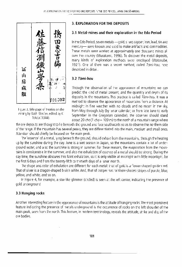
A N E X P L O W I O N METHOD FOR THE ORE DEPOSITS N T HE EDO PERIOD, JARAN: SANSO-HIROKL
3. EXPLORATION FOR THE DEPOSITS
3.1 Metal-mines and their exploration in the Edo Period
In the Edo Period, seven metáis —gold, silver, copper, iron, lead, tin and mercury— were known and used to make artifacts and commoditíes. These metáis were worked at approximately one thousand mines all over the country (Murakami, 1996). To discover the metal deposits, many kinds of exploration methods were employed (Watanabe, 1921). One of them was a secret method, called Tómi-hou, here described in detail.
3.2 Tómi-hou
Through the observation of the appearance of mountains we can predict the kínd of metal present, and the quantity and depth of its deposits in the mountains. This practice is called Tómi-hou. It was a method to observe the appearance of mountains from a distance. At midnight in fine weather with no clouds and no moon in the sky, from May through July (by lunar calendar; or from late June to early September in the Gregorian calendar), the observer should stand about 20 chó{1 c/?d= 109 m) to the north of a mountain range where
the ore deposits are thought to lie beneath the ground and face southwards so as to observe the northern side of the range. If the mountain has several peaks, they are differentiated Into the main, médium and small ones. Attention should chiefly be focused on the main peak.
The 'essence' of a metal, lylng beneath the ground, should exhale from the mountains, through the heating up by the sunshine during the day. June is a wet season in Japan, so the mountains contain a lot of under-ground water, and also the sunshine is strong in summer. For these reasons, the evaporation from the moun-tains is considerable In the summer, and also the exhalation of essence of a metal should be strong. During the day time, the sunshine obscures this faint exhalation, so it Is only visible at midnight with little moonlight, for the first 6 days and from the twenty-fifth to thirtieth days of a lunar month.
The shape and color of exhalation are different for each metal: that of gold is a flower-shaped golden red. That of silver is a dragon-shaped bluish white. And, that of copper has rainbow-shaped stripes of purple, blue, yellow, and white, and so on.
In Figure 4, for example, a star-like gllmmer (circled) is seen at the ieft center, indicating the presence of gold underground.
3.3 Hanging rocks
Another interesting feature in the appearance of mountains is the attitude of hanging rocks. The most prominent feature indicating the presence of metáis underground is the occurrence of rocks on the Ieft shoulder of the main peak, seen from the north. This feature, in modern terminology, reveáis the attitude, strike and dip, of the ore bodies.
l l l
B
Ai
M *
T J \ T
ft
* £
r 0 1 G 0 2
Figure 3. Title-page of Treaties on the mining by Sato Shin'en, edited by K
Tokita (1944).
101
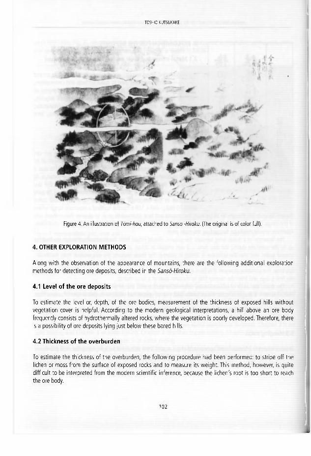
TOSHIFFLKLFFTUKAKE
Figure 4. An ¡llustration of Tómi-hou, at tached to Sansó -Hiroku. (The original ¡s of color íul l).
4. OTHER EXPLORATION METHODS
Along with the observation of the appearance of mountains, there are the following additional exploration methods for detecting ore deposits, described in the Sansó-Hiroku.
4.1 Level of the ore deposits
To estímate the level or, depth, of the ore bodies, measurement of the thickness of exposed hills without vegetation cover is helpful. According to the modern geological interpretations, a hill above an ore body frequently consists of hydrothermally altered rocks, where the vegetation is poorly developed.Therefore, there is a possibility of ore deposits lying just below these bared hills.
4.2 Thickness of the overburden
To estímate the thickness of the overburden, the following procedure had been performed: to stripe off the lichen or moss from the surface of exposed rocks and to measure its weight. This method, however, is quite diffícult to be interpreted from the modern scientifíc inference, because the líchen's root is too short to reach the ore body.
1 0 2

A N EXPIO R ATI O N METHOD FOR THE ORE DEPOSITS IN THE EDO PERIOD, JAPAN SANSO-HIROKU
4.3 Examination of the gossans and/or ore minerals
In Chapter 2 of this document treating on the gold mining, the following procedures are recommended to discover the gold deposits. At first the attention should be paid to the bald mountains without vegetations, where are the most likelihood to bear the gold deposits. If the gossan minerals of dark grayish or black color are found there, sometimes small purplish-blue spots are seen inside of the gossans. And also there are scattering the golden, purple, red or lizard-colored (grey) sulfide minerals, these are the strong indicators of the presence of gold deposits within the mountains. These sulfide minerals are frequently associated with gold.
4.4 Quality of ore deposits
Sketches of five gossans and thirteen sulfide minerals are shown in the illustration, attached to the document. They seem to be pyrite, marcasite, arsenopyrite and zincblende as sulfides while others appear to be oxide minerals. To estímate the quality of ores, weigh the residual metáis after burning a sample of the gossans. When more than 70% by weight metal (oxide) remains, it is a promising ore and worth mining.
5. SANSO-HIROKU AND 'REMOTE SENSING' V
Recently various remote-sensing techniques have been applied to the prospecting for the Earth's resources. Observation of the appearance of mountains, described in Sansó-Hiroku, can be regarded to be a kind of remote-sensing. The appearance of mountains seems to reflect the special geological features of the mining areas. For example, these areas frequently suffer hydrothermal alteration and consequently lack vegetation cover or are only poorly vegetated. Therefore, the reflection of light by the vegetated parts of mountain probably differs from those of the barren areas. The exhalation of essence of a metal due to the heating by sunshine is, bowever, improbable, and the visible faint glimmer is the most likely to be a reflected light of stars in the sky by a mountain slope lacking vegetation.
As mentioned, the location and orientation of the rocks exposed on the mountains indicates the geologi-cal structures of the area. The attitude of ore bodies is control ed by the host rocks and/or strata, and can be inferred from the local geological structures. Modern geological exploration for ore deposits normally begins with the examination of the exposed geological structures of the mountainous areas, and also underground.
Examination of the gossan and ore minerals is usually performed even in modern metal mines. The quality and quantity of reserves are estimated by the chemical analysis of these minerals. The practices for the evalua-ron of ore deposits, described in Sansó-Hiroku, thus have parallels in modern techniques.
6. SIMILARITIES TO THE ARISTOTELIAN METAL-GENESIS
Formation of metáis from the exhalation was discussed in the Aristotle's Meteorology (Adams, 1938). In the last paragraph of Chapter 6 of Aristotle's Meteorology, Volume 3, he describes as follows: there are two kinds of exhalations; foggy one and smoky one. Further, he regarded things under the earth, i.e., stone and metal, were made of these exhalations. Stones, such as realger, cinnabar and ochre which can't be melted, are made of dry (smoky) exhalations, whereas metáis, such as ¡ron, gold and copper which can be melted and are mal eable, are made of wet (foggy) exhalation (Lee, 1952).
1 0 3

TOSHIO KUTSUKAKE
According to the Sanso-Hiroku, as above-rnentioned, the 'exhalation' of a metal is visible above the moun-tains, which indicates the presence of Its ore body underground. It is interesting to mention that in the above both arguments on metal-genesis which appeared remote ¡n time and place, In the Ancient Greece and the Edo Period, Japan, the 'essence' of metal is comrnon and regarded as 'exhalation'.
7. CONCLUSIONS
a. Among the mining works and exploration methods for ore deposits in the Edo Period, Japan, there survives a secret document on the appearance of mountains, Sansó-Hiroku, inherited from the Sato Family in Akita.
b. The most ¡mportant and interesting exploration method is called Tómi-hou, i.e. watching the mountains from the distance.
c.The 'essence' of metal existing under the mountains produces 'exhalations', through the evaporation by the heat of sun during the day-time, and It is visible at midnight under a clear and dark summer sky,
d.The exhalation is said to be different in shape and color for each metal. e. Some of the gold and silver deposits are thought to have been discovered by this method in the Edo Period. f. It is also helpful to find ore deposits to look for hilltops without a vegetation cover. g. In the present paper, some other geological and mineralogical implications are also descrlbed for the explo-
ration methods for ore deposits. These are useful even today. h. As regards nature of metáis, some similarities can be seen between the argument in this document and that
of Arístotle of ancient Greece.
ACKNOWLEDGEMENTS
I am grateful to Prof. D. Oldroyd for his critical reading of the manuscript, valuable comments and improving the English.
REFERENCES
Adams, F.D. 1938/1954. The birth and development of the geological sciences. Dover Pubiications, New York, 508 pp. Lee, H.D.P. 1952. Anstotle Meteorologica. Loeb Classkal Librarles, London, 433 pp. Murakami, Y. 1996. Mine development in the Edo Period, Japan, In: Suzuki, K. (ed.), Mining culture in the Edo Period.
National Science Museum, Tokyo, 136-144 (in Japanese). Tokita, K. 1944. Treaííes on mining by SatóShin'en. Fuzan-bou Press, Tokyo, 262 pp. (in Japanese). Watanabe.W. 1921. Practica! exploration methods for the ore deposits. Kogyou-Shinbun C o „ Tokyo (in Japanese), 365 pp.
1 0 4

J. E. Ortfc, 0 . Puche, I. Rábano a r d L. R M a 7 a d « g o ( eds ) ffstuy^UssmhiiU^aesoixak Cuacetrtos del M u s e o Geominero, 13. Inst i tuto Geo lóg ico y M ine ro de España, Madr id . ISBN 9 7 8 - 8 4 - 7 8 4 0 - 8 5 6 - 6 6 ' i ^ t i t u t o Geo lóg ico y M ine ro de España 2 0 1 1
MATRICES, NOT SEEDS. VALLISNERI'S RESEARCH ON MINES: BETWEEN EMPIRICISM AND PHILOSOPHY
Francesco Luzzini
Univers l tá degl l S:udi de l P i e r n ó n » Orlentale, D i p a r t i m e m o d i Stud' Umanis t ic l , Vía G. Fera r i s 1 1 6 , 1 3 1 0 0 Vercell i , Italy Ed¡zione Naz iona le del le Opere di A n t o n i o Vall isneri. Via A De Togni 7, 2 0 1 2 3 M i lán , l ialy.
f r a n c e s c o J u z z i n i S y a h o o . c o m
Abst rac t . Since the beginning of his scientific actívity the physician and naturalist Antonio Valli-sneri (1661-1730) devoted many studies to the Earth sdences. In those years his interest focused particuiarly on the features of mineral k ingdom and its relationship w i th spring water. The first observations date back to the last decade of XVII century, when the author analysed the gypsum and sulphur veins on the Mon te Gesso, in the Duchy of Modena and Reggio. Some years later, during one of his journeys across the northern Apennines in search for the origln of springs, Vallisnerl reached the Este domain of Garfagnana, There he explored the iron caves of Fornovolasco: this experience al lowed him to support his theory w i th many empirical informat ion, later exposed in the Lezione Accademica intorno all'Origine deíle Fontane (1715). The many data collected by Vallisneri encouraged him to out l ine a theoretical interpretat ion of mineral genesis. He supposed the mineral velns as developed by 'seeds' released in the Earth by God. The successful g rowth of ore veins, therefore, depended on the more or less favourable environment they woulcl have found by accident. These 'seeds', as the author dar i f ied, were not intended to be the very same of 'perfect germs of generat ion' typical of animals or plants. Rather, they were 'matrices' that had to be detected in order to explolt the weal th of mines posed, in a proper Leibnizian conception, 'by God for wor ld 's use'.
1. INTRODUCTION
in 1687, after he studied medicine at Bologna University, young Antonio Vallisneri (1661-1730) returned in his homeland, the Duchy of Modena and Reggio, where he began to serve as general practitioner in Scandiano and Luzzara. Since these early days Vallisneri devoted his pastime to various sorts of scientific subjects ('bright studies', as he called them). He accurately reported these experíences in his Quademi di osservazioni(Vallisneri, 2004): naturalista diaries in which the author proved his skill in different experimental fields like entomology, microscopy, botany and, of course, medicine.
A small, but significant part of the Quademi was filled with Earth sciences related notes. The author re-served a keen interest for the gypsum and sulphur veins recently discovered on the Monte Gesso (Fig. 1): a mountain located in the gypsum-sulphur formation typical of the northern borders of the Apennines, whose thick evaporitic strata result from the Messinían salinity crisis occurred in the late Miocene epoch. (n a first,
I O S

FRANCESCO LUZZINI
remarkable note, dateci November 1691, Vallisneri reported the new finding and tne prompt economic concern shown by the authorities:
«It has been discovered ¡n our Monte Gesso a new sulphur veln, that once tested has resulted to be of a greater perfectlon than the commonly sold kind. The Most Serene Prince ordered to bring here a certain Mr. Raggl from Romagna, ¡n order to work and to discover the mine, but nothing has been revealed yet» (Vallisneri, 2C04, p. 35).
Figure 1. A gypsum outcrop on Monte Gesso (Albinea, Reaoio Emilia, Italv). Picture by Stefano Meloni.
Figure 2. A detail ot the gypsum outctrop on Monte Gesso (Albinea, Reggio Emilia, Italy). Picture by Stefano Meloni.
2. INTHE FIELD
Vallisneri carefully studied the Monte Gesso, collecting many specimens and precious information about seve-ral features of the rocks (Fig. 2). He also analysed the surroundlng geological context, not even despising to explore some of the caves near to the mountain. In May 1694 he discovered in a cavern «a dark and chilly site», where he saw a spring whose «most clear and cool water» was «rejected by the beasts». He tasted it, and found it was extremely bltter. This peculiarity was to him a proof of the underground presence of gypsum:
«The origin [of the bitterness] is not a mistery, being the mountain entirely made by gypsum. The spring likely passes between chalky stones, whose bitter partides soak in the water. Perhaps the underground heat or the sulphur itself caldned them, so that they are partially dissolved, and washed away by the flow» (Vallisneri, 2004, p. 42).
In this brief account it is already possible to detect a tendency, characteristic of Vallisneri's experimental practice, to take into great consideration the existing relationship between two or more analysed phenomena in the same environment. As a matter of fact, the connection between the research on springs and the study of minerals was not a case apart in Vallisneri's scientific activity. In 1700, after the author had obtained the chair of practical medicine in the University of Padua, he carne to be deeply ¡nterested in the polemic on the origin of freshwater. The dominant theory in those years, which derived from the Cartesian assumption of slembics, considered the springs as originated from seawater after a process of filtration through rock strata. The data previously collected on the field and the correspondence with Diacinto Cestoni (1637-1718), a skilled apoth-ecary from Leghorn (Cestoni, 1940, pp. 83, 84-85, 95-96, 344; 1941, pp. 462, 463, 467-468, 469, 577, 704,
1 0 6

MATRICES, NOT SEEDS. V A L L I S N E R I ' S RESEARCH ON MINES: BETWEEN EMPRICISM A N D PHILOSOPHY
707, 710,711,783), persuaded Vallisneri that all the freshwater carne from rain or f rom the melting of glaciers on the mountains. Consequently, he firmly opposed the a/emb/csbelief (Generali, 2007, pp. 326-331).To prove his theory by experimental means, he devoted hlmself to perform varlous journeys in the Apennines, collecting many useful pleces of information.The most important of these field trips was the one he made in the summer of 1704, when he leaved the first hills south to Reggio Emilia and reached the Tuscan región of Garfagnana. The report of this adventure (Vallisneri, 1705), a key experience for Vallisneri's research in the field of Earth Sciences, was written in Latin. A copy of the manuscript was sent to the Royal Society, although remaining unpublished. Two decades later a synthesis in Italian was published in two tranches - Estratto d'alcune Notizie íntorno alia Provincia delia Garfagnana and Continuazione del/'Estratto d'alcune Notizie intorno alia Garfa-gnana, In 1722 and In 1726 - on the «Supplementi al Giornale de' letterati d'ltalia». Though from the writing style it appears that these published texts were composed by Vallisneri himself (Generali, 2004, pp. 155-156, 176-177; Vallisneri, 2006, pp. 872, 895), the authorship was officially attributed to Giambattista Perrucchini, one of hls pupils- Vallisneri often adopted this strategy, in order to better defend himself against potential criti-cisms (Generali, 2007, pp. 383-412).
In the account it can be noticed a constant attention both to the hydrological and mineralogical features of the mountains. A clear example of this tendency is the first reported observation, concerning, once more, the Monte Gesso and the sulphur mine (now exploited) that had been finaliy discovered «west of it, about one mile [from the city of] Scandiano» (Vallisneri, 1722, p. 279). The mine itself had been revealed by means of water, passing the little riverTresinaro so dose to the mountain that «by eroding from side to side, it dragged along with stones, days and gravéis also pieces of puré sulphur, that once observed [ . . . ] gave opportunity to search for the place from where they aróse» (Vallisneri, 1705). Accordlng to a marginal note written in Italian and contained in the original — a n d feroclously reworked— Latín manuscript, the wealth of the mine was far from negligible.The single river carried enough sulphur to be used «by poor people» for the production of matches to be sold. Once discovered, then, the ore vein was so abundant to satisfy all the near citles. Nelther the quar-ries were small in slze, being wide enough to let the work of two standing men «with their tools to carry out the extracted mineral». Two were the pits «made by art» (Vallisneri, 1705); they were interconnecting, in order to enable the required air passage.
It is worth of notice an observation made [by the author] on the alignment of puré sulphur layers, being them wedged in the mine's clay beyond the clods [with the mineral] that are found hither and yon in various sizes. The first [layers] are llke trees with the tops and the branches tending down, and the more water seeps and drips from above, the more they flourish; which [data] more and more confirm that all the water in the mines, and in the springs comes from rain and from melt snow (Vallisneri, 1722, pp. 279-280).
Once reported the exploration of the sulphur pit, the account goes on describing the rest of Vallisneri's voyage. The author moved south and crossed the valleys of river Dolo and Dragone, where he noticed many specimens of marcasite and other «apparent dues of hidden mines». Having at last passed the «hard yoke of Apennines» (Vallisneri, 1722, pp. 286-293), he carne in the valley of Garfagnana: an Este enclave in Tuscan territory.There he met Domenico de' Corradi D'Austria (1677-1756), chief superintendent of artillery on behalf of the Duke. As an expert mlner, he led Vallisneri in the Iron caves of Fornovolasco (Fig. 3, 4), allowing him to support hls theory with condusive empirlcal information:
«Entering into the mines, or into the caves in the mountains, for those who examine properly it is always possible to see water falllng from above, or following on a slope the path of the dnghioni, or layers. I have made repeatedly this observation in various pits, [ . . . ] and especially in the sulphur ones in Scandiano, and in the iron and vitriol ones, [ . . . ] In the latid called Forno Volastro.
[ . . . ] I have always observed that, e\ien if sometimes water seems to stream from the bottom of the mines,
1 0 7

FRANCESCO LUZZINI
l igure 3. Entrance of an ¡ron mine in Fornovolasco, Figure 4. Waste matter in the ¡ron mines. Fornovolasco, Garfagnana (Lucca, Italy). Garfagnana (Lucca, Italy).
nonetheiess those who will look very weii wiii see under it [the bottom] a bed of stone, or marga, that prevents [the water] from falling further, and the other upper layers will be otherwise placed, or splitted, or fractured» (Vallisneri, 1715, p. 46).
Corradi's practical experience was regarded with great esteem by Vallisneri, being the Paduan professor a proud advócate of the «philosophical candour» of empiricism against the speculative assumptions of those labelled by him as «long bearded, and not short gowned men» (Vallisneri, 1706). This polemical approach was preserved by the author when, after having arranged the many collected data in a consistent theory, he published the LezioneAccademica intorno a\\'Origine deile Fontane (Vallisneri, 1715). In this treatise he proved the origin of springs to result from rain and melting glaciers; at the same time, he confuted the existence of filtering devices to convert salt water into freshwater. The centerpiece of the thesis, of course, was the vast mass of experimental information collected by the author (and by some reliable observers, as in this case, Corradi).
The Lezione Accademica was dedicated to the great mining expert Luigi Ferdinando Marsili (1658-1730). Ironically, this nobleman, who had an experience in mineral research and in cave exploration far greater than the one possessed by Vallisneri, was in part a supporter of the Cartesian theory of alembics. Nevertheless, the author was a sincere admirer of Marsili's knowledge and of his renowned mineral collection, as shown by the correspondence (Vaccari, 2003; 2008). In a letter dated 10 January 1705 Vallisneri informed Marsili of his inter-est in mineral kingdom, and prayed him to send some specimen from his rich museum. He also asked Marsili for some information on the water in mines, showing to count on him as an authority in Earth Sciences:
«[ . . . ] in this [subject] I know there is no man who can enlighten me more than Your Lordship, [ . . . ] in fact you had the opportunity to satisfy your hunger for sure information in the wealthy mines of Hungary [ . . . ] I therefore beg you for the time being to give me two data: if you have observed in all the mines some streams or springs, and the second, if you believe that all the springs come from rain, or snow, or both from these and from the sea» (Vallisneri, 1991, p. 282).
Marsili's judgment, with regard to the second question, leaned toward the thesis of compound origin of fresh-water. This disagreement with Vallisneri, anyway, did not prevent the two naturalists from being on good terms.
Vallisneri's interest in minerals did not fade in the following years. He made other observations in the Emil-ian mines, also paying special attention to the techniques employed by workers to extract gypsum and sulphur.
1 0 8

MATRICES, NOT SEEDS. VALLISNERI'S RESEARCH ON MINES: BETWEEN EMPRICISM A N D PHILOSOPHY
These studies were later published in 1728 in the Raccolta di varié Osservazioni, Spettanti all'istoria Medica, e Naturale. From these detaüed accounts it appears that the mine industry was well tested and properly organ-ised.The miners at first made holes in the mountain by means of drills, then filled up the cavities with exploslve («rifle powder»). Once this operation was complete, the holes were sealed with «diluted gypsum» and a little fissure was Ieft to put the fuse in; after the explosion they broke the biggest pieces with iron mallets, «in order to carry them easily to the kilns». There the gypsum was calcined and prepared «in just 24 hours of fire» (Val-lisneri, 1728, pp. 138-139).
3. ON THE GROWTH OF MINERALS
Through the works of Dario Generali {1987; 2002, pp. 70-72), modern historiography hasshown thatVallisneri, despite his claim for the preeminence of experimentalism over speculation, made empiricism coexist with phi-losophy. From a substantial adherence to the Cartesian principies during his early years of activity, and being later attracted by Nicolás Malebranche's thought, the author carne at iast to be deeply influenced by Leibniz's philosophy, whose theories he learned from his correspondence with Louis Bourguet (1678-1742). He also read himself some of the most important books of the Germán author, as, for instance, the Théodicée (Lelbniz, 1710). The doctrines of 5cala naturas and of the recognition of divine providence in the creation significant!y affected his research; the studies on Earth sciences were not an exception, as it is to be presumed.The many data collected in more than two decades of activity encouraged him to outline a theoretical interpretation of mineral genesis that he disclosed in a let terto hisfriend Louis Bourguet in the summer of 1721. The naturalist had observed in some mines near to Bern many stones mixed with «grains of salt», and «crystallized salt» (halite, probably) between stone layers. To Vallisneri, these findings were 'seeds' of minerals evenly released in the Earth by the Creator. The successful growth of ore veins, therefore, depended on the more or less favourable environment they would have found by accident:
«[. . . ] where [the seeds] have found the proper conditions, they have multiplied, and on the contrary, where they have not found [the conditions], they have remained as simple traces [ . . . ] Omnia in ómnibus, said a great philosopher. In the mountains we can find every kind of mine, but a rich one here, a poor one there, elsewhere one so narrow that the traces are barely visible. Consider the example of gold, silver and other met-áis mines. In Italy we have them all, but due to the lack of a proper nourishment, they neither multiply, ñor bear fruit, and we barely get a glimpse of their first seeds, or vestiges. The same we see to happen to plants or animals, that in a place reproduce, in another become infertile, because of the climate, or of the nutrition, etc.» {Vallisneri, 2006, p. 668).
This theory did not arouse enthusiasm in Bourguet, who firmly refused the supposition that minerals would need a sort of nourishment. He clearly expressed his opinion in October of the same year:
«I can't recognize the great genius of my beloved Mr Vallisneri, in your discourse on the minerals dropped like seeds of the mines in the mountains; [ . . . ] a superstition of chemists, who want to turn the mineral kingdom into plants! And this [belief] is so bogged down in their brains, that it is almost impossible to uproot it even from the minds of the wisest among them. Minerals that need nourishment to feed and grow. For God's sake! It is a great paradox to those who understand the natural science!» (Bourguet, 1721).
Bourguet insisted on one point in particular: if not supported by «physical, and mechanical experiences», these hypotheses were nothing more than «vain suppositions» (Bourguet, 1721). Vallisneri was not indifferent to these words. Replying to his friend, he tried to refine his theory, justifying it on the basis of its adherence to the Leibnizian principie of harmony.The 'seeds', he clarified, were not intended to be the very same of «perfect
1 0 9

FRANCESCO LUZZINI
germs of generatíon» typícal of animals or plants. Rather, they were 'matrices' («having no more expressive definitions», as he wrote}. Boyle and Agrícola stated that an éxpioited mine, exposed to air for many years, would fíll again with minerals. This phenomenon, anyway, happened only in those lands provided with 'matri-ces' that, once nourished, would bear new fruit.
«You know that nature procreates and produces in a consistent order, graduaily improving ¡the creation] up to man. We see that all the reproducing and growing beings have their own seed, or matrix; therefore, we see that it remalns valid also for minerals, that grow and multiply inside and outside of the mines. The result is the same, thus the cause must be the same, or at íeast analogous, unless the greater or less perfection» (Val isneri, 2006, p. 738).
This clarification by the author, probably, answered to the need to make a clear distinction between his thought and the 'theories of seeds' supported by many Neoplatonic scholars in the sixteenth and seventeenth centuries (Norris, 2009; Oldroyd, 1996, pp. 7-41; Rudwick, 1972, pp. 1-45). Whatever was Vallisneri's purpose, Bourguet's answer, one more time, was sharp and far from ambiguous: the belief that a mine deprived of its ore veins would refill after some time was «absolutely false». What Boyle and Agrícola observed were nothing else but residual «metallic particles» that had remained in the quarries. Neither the chemists, ñor the philoso-phers of good sense had to use terrns like 'seeds' and 'generation' to explain the growth of minerals. They were equivocal words, that had «nothing in common with the real meaning» (Bourguet, 1722).
4. CONCLUSIONS
The opinion expressed by his friend Bourguet most likely had a deep influence on Vallisneri. Still remaining a faithful advócate of the Leibnizian principie of scala naturae, the Paduan professor concisely exposed his thought on 'matrices' in the Continuazione dell'Estratto (Vallisneri, 1726, pp. 395-396). Nevertheless, except for this paper - that, perhaps not by chance, he ascribed to Perrucchini - after 1722 he did not seem to persist in supporting his theory on mineral genesis and growth. A major role in his choice was probably played by the lack of empirical verlfication of this hypothesis: being him an earnest experimentalist, Vallisneri could not honestly defend arguments with no objective proof. As in other circumstances involving the study of natural phenomena, he seemed to be more at ease with experimental activity than with philosophical eiaboration (Monti, 2008; 2009). Anyway, these two facets constantly influenced the evolution of Vallisneri's thought. Far from being mutually exclusive, solid science and philosophy interacted in this author, and in many cases allowed him to work on theories strong eriough to prevail on rival theoretical systems. Despite its result and its marginal importance in the vast mass of the works devoted by Vallisneri to the Earth sciences, the study on the origin and growth of minerals is emblematic of this attitude.
REFERENCES
Bourguet, L. 1721. Letter from L. Bourguet toA. Vallisneri, October 12th, 1721. Modena, Biblioteca Estense, Mss. It. (ms. IX. F. 11).
Bourguet, L. 1722. Letter from L. Bourguet to A. Vallisneri, February 4th, 1722. Modena, Biblioteca Estense, Mss. It. (ms. IX. F. 11).
1 1 0

MATRICES. NOT SEFDS. VALLISNERI'S RESEARCH O N MINES: BETWEEN EMPIRICISM AND PHILOSOPHY
Cestón!, D. 1940. Epistolario adAntonio Vallisneri. Parte I. eclited by Silvestro Baglioni, RealeAccademia d'ltalia, Rome, 83, 84-85, 95-96, 344.
Cestonl, D. 1941. Epistolario ad Antonio Vallisneri. Parte II. Edited by Silvestro Baglioni, RealeAccademia d'ltalia, Rome, 462, 463,467-468, 469, 577, 704, 707, 710, 711, 783.
Generall, D. 1987. Antonio Vallisneri "corrlspondente leibnlziano". In: Cavazza, M. (ed.), Rapporti di scienziati europei con lo Studio bolognese ira '600 e 100. Studi e Memorie per la Storia dell'Universitá di Bologna, Nuova Serie, vol, VI, Presso l'lstltuto per la Storia dell'Universitá, Bologna, 125-140.
Generali, D. 2002. Storia e storiografía della scienza. In: Andrietti, F. y Generali, D. (eds.), Storia e storiografia de/la scienza. II caso della sistemática. Franco Angeli, Milán, 70-72.
Generali, D. 2004. Bibliografía delle Opere di Antonio Vallisneri. Olschki, Florence, 155-156, 176-177. Generali, D. 2007. Antonio Vallisneri. Gli annl della formazione e le prime ricerche. Olschki, Florence, 326-331,
383-412. Monti, M.T. 2008. Vallisneri e lo strano caso dell"lstoría', trattato d¡ parole, gesti e afasie. In: Generali, D. (ed.),
Antonio Vallisneri. La figura, il contesto, le immagini storiografiche. Proceedings of the international meet-ing on Antonio Vallisneri, Milán, June 21st to 23rd, 2006, Olschki, Florence, 157-193.
Monti, M.T. 2009. La scrittura e i gesti deH"lstoria'. In: Vallisneri, A. (ed.), Istoria della generazione. Vol. I, edited by Maria Teresa Monti, Olschki, Florence, XV-XCVIII.
Norris, J.A. 2009. The providence of mineral generation in the sermons of Johann Mathesius (1504-1565). In: Kolbl-Ebert, M., (ed.), Geology and Religión: A History of Harmony and Hostility. Proceedings of the INHIGEO Symposium in Eichstátt, Germany (July 28th to August 5th, 2007), Geological Society, Special Pubiications, 310, 37-40.
Oldroyd, D.R. 1996. Thinking about the Earth:A History of Ideas in Geology. Athlone, London, 7-41. Rudwick, M.J.S. 1972. The meaníng of Fossils: Episodes in the history of Paleontology. University of Chicago
Press, Chicago, 45 pp. Vaccari, E. 2003. Luigi Ferdinando Marsili geologlst: from the Hungarian mines to the Swiss Alps. In: Val, G.B.
and Cavazza, W. (eds.), Four Centuries ofthe Word Geology. Ulisse Aldrovandi 1603 in Bologna, Minerva Edizioni, Bologna, 179-185.
Vaccari, E. 2008. Antonio Vallisneri, Luigi Ferdinando Marsili e la «struttura de' monti». In: Generali, D. (ed.), Antonio Vallisneri. La figura, il contesto, le immagini storiografiche. Olschki, Florence, 391-432.
Vallisneri, A. 1705. Prími itineris per Montes specimen Physico-Medicum. Manuscript. Archivlo di Stato di Reg-gio Emilia, Archivio Vallisneri, 10, Scritti, minute e appunti scientífid e ietterari d'Antonio Vallisneri sr., mazzo IV.
Vallisneri, A. 1706. Breve Relazione di quanto ha osservato nelleTerme Euganee II Sig. Antonio Vallisneri. l a Gallería di Minerva, V, 110-114.
Vallisneri, A. 1715. Lezione Accademica intorno all'Origine delle Fontane, colle Annotazioni per chiarezza mag-glore della medesima, di Antonio Vallisnieri, Pubblico Primario Professore di Medicina Teórica, e Presidente nell'Universitá di Padova. A Sua Eccellenza il Sig. Generale Co. Luigi-Ferdlnando Marsilli. Appresso Gio. Gabbriello Ertz, Venice, p. 46.
Vallisneri, A. 1722. Estratto d'alcune Notizie intorno alia Provincia della Garfagnana, cavate dal primo Viaggio Montano del Sig. Antonio Vallisnieri dal Sig. Dottore Giovanbatista Perrucchini, e da luí indirizzato in una Lettera al Sig. Lodovico da Rlva. Supplementi al Giornale de' letterati d'ltalia, II (VII), 270-312.
Vallisneri, A. 1726. Continuazlone dell'Estratto d'alcune Notizie intornial la Garfagnana, cavate dal primo Viaggio Montano del Sig. Antonio Vallisnieri. Supplementi al Giornale de' letterati d'ltalia, III (VIII), 376-428.
Vallisneri, A. 1728. Raccolta di varié Osservazíoni, Spettanti all'lstoria Medica, e Naturale dal Signor Antonio
1 1 1
FRANCESCO LUZZ NI
Vallisneri, Pubbüco Professore Primario dell'Universitá di Padova, Medico di S. M. C. C. Socio deü'Accademia Reale di Londra ec. scritte agii Eruditi, o dagli Eruditi a Lui: con varié Annotazioni, e Giunte, compilata da Gio. iacopo Danielli, Medico, e Filosofo di Padova, e consacrata all'lilustrissimo Signor Conté Jacopo fíic-cati. Per Domenico Lovisa, Veníce, 138-139.
Vallisneri, A., 1991. Epistolario. Vol.! (1679-1710). Edited by Darío Generali, Franco Angelí, Milán, 282 pp. Vallisneri, A. 2004. Quadernidi osservazioni. Volume I. Edited by Concetta Pennuto, Olschki, Florence, 35,42. Vallisneri, A. 2006. Epistolario (1714-1729). Edited by Dario Generali, Olschki, Florence, 668, 738, 872, 895.
1 1 2

J. E. Ortiz, 0 . Puche, I. R a b a i o and L F. M u a d t e g o (eds.) Hiüory oí tesar*) « i M í w a f N e s o w c s s Cuadernos del M u t c o Geo'n i / ierü , ' 3 Instituía Geológico y M i m o de España. M a d f i c . ISBN 9 7 S - S 4 - 7 8 4 0 - S 5 6 - 6 © nstituto Geo ing i ra y M ine ro de Espara 2 0 1 1
PAKOHE - A ROCK THAT SUSTAINED EARLY MAORI SOCIETY IN NEW ZEALAND
Mike Johnston
3 9 5 T-afalgar Street, Nelson 7 3 1 0 , N e w Zealand m ike . j ohns to r@xt ra .ee . n ;
Abstract . In the eastern ranges of Nelson, ¡n the northeast of the South Island of New Zealand, Maori extensively worked a fine graíned mudstone, "pakohe" , into tools. In the Archaic Period, datlng from when Maori arrived in New Zeaíand in the 12th or 13th century to about the end of the 15th century, pakohe was, after the much rarer pounamu or qreenstone (nephrite), the preferred material for stone implements. Boulders of pakohe from tne coast and in the rivers were worked into the required shape using marine rounded hammer stones of granodiorite. The source of the pakohe was traced ínland to a distinctive belt of barren dun weathered outerops dominated by serpert i r i te. Europeans who founded Nelson in 1841 named these rocks the Nel-son Mineral Belt. Scientifically it is the Dun Mountain Ophiolite Belt, a slice of Permian oceanic crust and upper mantle.The pakohe occurs as rootless blocks up to c. 10 m or more across, wi t lnn melanges.The blocks protrude above the general level of the land and was broken Into sultable sized pieces using boulders of granodiorite. Al though pakohe is an extremely touqh rock, due to the presente of albite and tremolite, it splits conchoidally thereby making it possíble to work. As the Archaic Period gave way to the Classic Period of Maori culture the use of pakohe declined in favour of more locally sourced rocks throughout New Zealand. The reasonsfor this are obscure, but are probably linked to a cooling climate and the extinction by hunt ing of the giant f l ight-less Moa, which all contributed to putt lng pressure on Maori society. It this appears that those working and distributing pakohe were displaced by tribes moving into the Nelson area in the competidor for food and other resources. Wi th the Introduction of iron tools coupled wi th the advent of the inter-tribal musket wars in the early 19th century, the quarries were abandoned and by the time of the European settlement they were forgotten. They were redíscovered during the latter part of the 19th century but, except from local amateur naturalists and ethnologists, they in i t ia l lygained no other recognition. The founding o f t h e Polynesian Society in 1892 placed the study of ethnology on a more permanent foot ing although It was not until t w o decades later that the first descriptions of the quarries appeared by Henry Devenish Skinner (1886-1978) and James Alian Thomson (1881-1928) in 1910 and 1918 respectively.
1. INTRODUCTION
New Zealand is the most recently inhabited country in the world with the indigenous Maori arriving from the tropical and sub-tropical islands of the central Pacific in about the 121 or 13"1 centuries. Although New Zealand, comprising two main islands, is largely mountainous it has a temperate climate with plentiful food and rock re-sources. Fish and birds, including the large flightless Moa, were in abundance. Whlle there were no land mam-mals, other than two species of bats, the coast abounded In seáis and stranding of whales and dolphins also yielded food and bone. There were large areas of forest that provlded wood for the construction of buildings
6 1

MIKE JOHNSTON
and canoes as well as for fuel. Flax and vines were utilised to rnake clothing, ropes and nets. Plants, partlcularly fern roots and berrles, were also a source of food. As well as ¡ndigenous resources, the Maorl brought with them to New Zealand a number of plants and anlmals, ¡ncluding the sweet potato or kumara, yams, dogs and rats. Although a tradltlon of pottery exlsted ¡n the central Pacific, being brought by the ancestors of Maori from Asia several millennia earlier, it was never introduced in New Zealand where day abounded.
While the first documented European visit to New Zealand was by Abel Janszoon Tasman (1603-1659) in 1642, it was not until the early 19th century that European tools fully supplanted Maori stone culture. A range of different rock types were utilised for making tools and to a lesser degree ornaments. These included pouna-mu or nephrite, a form of jade, and an altered or metasomatised mudstone known to the Maori as pakohe (Fig. 1) and to the early European settlers as "baked argill ite". In addition there are a variety of hard sandstones and igneous rocks, particularly basalt, that are suitable for tool manufacture. Quartz in the form of rock crystal, quartzite and obsidian were broken into fragments with razor sharp edges that were used as knifes for cutting flesh and materials. Ochre and a few other minerals supplemented natural dyes for colouration of buildings and body ornamentation. In addition, in the central North Island geothermal steam and hot springs were utilised for cooking and heating. Other minerals and rock resources that New Zealand had an abundance of, such as alluvial gold, coal and, other than for ochre as a colouring médium, iron ore were never exploited by Maori.
y. * Um f t n $
Figure 1. Examples of pakohe adzes (drawn adzes on the right f rom Challis 1978).
Although New Zealand, for its size, has a huge diversity and an abundance of hard rocks there were reia-tively few that had the necessary characteristics to be consistently made into tools. These characteristics were sufficient toughness so that they would not break during use, they were capable of being sharpened so as to maintain a cutting edge and critically they could be worked into a suitable shape. Of these, the greatest limitlng
6 2

PAKOHÉ - A ROCK THAT SUSTAINED EARI.Y MAORI SOCI t lY IN NEW ZEALAND
factor was workability bearing ¡n mind that the Maori could only do so with rock. While set patterns for tools like adzes evolved, many were manufactured on an opportunistic basis when a piece of rock of suitable quality and shape was fortuitously found, such as loose material naturally spalled from an outcrop or found as float in rivers or on beaches. For example, hard sandstones are widespread in New Zealand but in outcrop they were almost impossible for the Maori to work. Nevertheless, sandstone boulders are abundant in many rivers and, due to winnowing during movement, softer boulders or those containing planes of weakness are eliminated. Such rivers had the potentíal of yielding pieces of rock of suitable quality and size that did not require a huge amount of preparatory work. Nevertheless, of all the rocks that were worked, the most in demand were pou-namu and pakohe, both of which are associated with ultramafic rocks. Both pounamu and pakohe are hard and tough and could be highly pollshed. Of the two pounamu, was the more prized because of its beautiful green translucent colour and that it could be sawn and carved (Beck and Masón, 2002).
2. POUNAMU
While most tools made of pounamu were primariiy adzes and chisels for fine carving, they tended to have more intrinsic valúes and were treated as treasures or taonga. This was particularly so for mere, a type of short club used in cióse combat fighting as well as a sign of rank or authority. Pendants included the elaborately carved hei tikl that was hung around the neck.To Maori these objects had their own mana which can be interpreted as authority, prestige or power, and were handed down from one generatlon to the next.They could be given as an act of friendship or their loss in battle exemplifled defeat or submission.
Nephrite obtains Its toughness from the presence of interlocking crystals of tremolite, a calciurn-magne-sium amphibole. Most of the high grade nephrite is derived from thin lenses of Pounamu Ultramafics within highly metamorphosed sedimentary rocks of Permian or early Mesozolc age exposed in the Southern Alps in the west of the South Island {Fig. 2). As far as is known these were not worked by the Maori and instead boul-ders were coilected from the rivers draining the alps or from coastal beaches where gravel is constantly moved by longshore drift. These processes progressively reduced the boulders in size, making them more manageable as well as removing any softer layers such as serpentinite. Because the rivers are large and frequently flood, they shift huge volumes of gravel so that even though they were not common, there was no significant decline in the availability of suitable boulders for tools. Nephrite and semi-nephrite is also derived from the Dun Moun-tain Ophlollte Belt and its associated melanges that are exposed at either end of the South Island, In Nelson and Otago-Southland, on opposite sides of the Alpine Fault. However, the amount of nephrite or semi-nephrite eroded from the belt is small, particularly in Nelson. On the other hand pakohe within the northern melanges Is relatively widespread.
3, PAKOHE
The most widely exploited rock in early Maori settlement, commonly referred to as the Archaic Period that ended at approximately the end of the 15"1 century, is pakohe. Although commonly referred to as argillite this term is unsuitable in that it is not greater induratlon that gives the rock Its exceptional properties but chemical alteration arising from the formation of various minerals, mainly albite and tremolite. In particular, tremolite has imparted an Interlocking felted fabric that replaces the platy fabrlc of the original mudstone thereby giving pakohe additional strength and toughness (Reed, 1959). While the qualification of baked or metasomatised
6 3
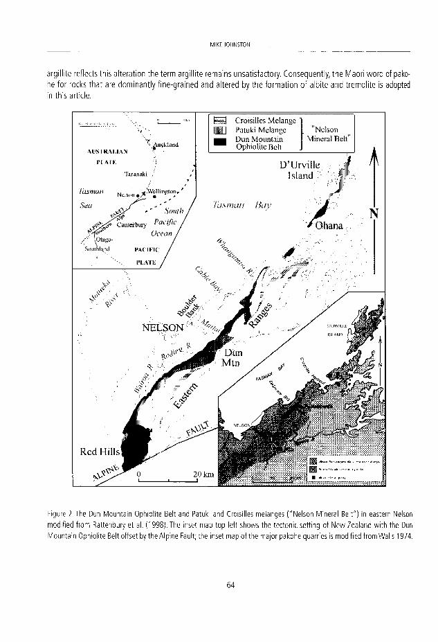
MIKL JOIINSTDN
argillite reflects this alteration the term argillite remains unsatisfactory. Consequently, the Maori word of pako-he for rocks that are dominantly fine-grained and altered by the formation of albite and tremolite is adopted in this article.
N # | Croisiltes Melange U ] Patuki Melange "Ncison
Dun Mountain Mineral Bell" Ophioli te Belt '^uíklatK
Al STRAi.lAN PL AI'E
Taran akí
'¡asman NdSü„ # ¿WclUng.™,'
Figure 2. The Dun M o u n t a i n Ophio l i te Belt and Patuki and Croisilles melanges ( "Ne l son Minera l Be l t " ) in eastern Nelson modi f ied f r o m Rattenbury et al. (1998) . The inset map top left shows the tectonic set t ing of N e w Zealand w i t h the Dun Moun ta in Ophio l i te Belt o f fset by the A lp ine Fault; the inset map of the m a j o r p a k o h e guarnes ís modi f ied f r omWal l s 1974.
6 4

PAKOHÉ - A ROCK THAT SUSTAINED EARI.Y MAORI S O C I t l Y IN NEW ZEALAND
Pakohe is mostly found ¡n the ranges of east Nelson, ¡n the northeast of the South Island, and was exported ítfi'roughout New Zealand. It occurs as blocks wlthin the Patuki Melange on the southeastern side of the Dun Mountaln Ophlollte Belt and ¡n the very dlscontinuous Crolsilles Melange that crops out up to 10 km farthe,'
•east (Rattenbury et al., 1998; Fig. 2). The ophiollte represents a slab of Early Permian oceanlc crust and underly-ing ultramafic rocks of the upper mantle, the latter domlnated by serpentinite, that was emplaced Into conti-nental crust on the margin of Gondwanaland. Because traces of copper and chromite were found by European
¡settlers ¡n the ultramafic rocks in the late 1850s, they and their associated rocks were collectively referred to as SKe "Nelson Mineral Belt". Soils derived from the weathering of the ultramafics are rich in magnesium, which prevenís the uptake of what little calcium is available, resulting in a stunted vegetation that at higher altitudes •ís dominated by shrubs and tussock among which protrude outcrops of rusty weathering outcrops. This vegeta-tion contrasts markedly with the forest on more normal rocks that endose the serpentinitic and related rocks. Mountains in the belt had bestowed on them ñames such as Red Hill, Red Hills and Dun Mountain by the
:European settlers. However, at lower altitudes denser vegetation tended to prevalí. When the ophiolite was emplaced, blocks of the adjoining country rock along with parts of the ophiolite,
were fragmented and enclosed in a matrix dominated by sheared serpentinite resulting in the melanges. The Blocks range in size from less than 1 m to over 1 km in length although most are no more than tens of metres across (Fig. 3). As they were incorporated into the melanges most of the blocks were tectonically rounded, par-•ticülarly the smaller ones, and many have been altered by metasomatism with the formation of new minerals.
Figure 3. A partly worked in situ block of pakohe, c. 6 m in height, at the Rush Pool Quarry.
6 5

VIIKT J0HNST0N
This is particularly evident in blocks of mudstone, which rarely exceed the size of a small cottage. The mudstone almost always has a consistent homogeneous texture and varíes in colour from light to dark grey to black, al-though green, white and red streaks may be present. The streaks represent sparse thin sedimentary layers that have become distorted during metasomatism. Although lackíng the translucent green beauty of pounamu, pa-kohe is capable of taking a very high polish, which with its toughness, is now making it increasingly in demand by carvers. Unlike pounamu, pakohe couid not be sawed by Maori but as it has a well developed propensity to fracture conchoidally, this allowed it to be worked and shaped. As the ophiolite and its associated melanges are well developed in eastern Nelson from D'Urville Island southwards through Dun Mountain, it is no coincidence that the greatest number of sites for manufacturing adzes and other tools are found there (Walls, 1974).
Figure 4. A diagrammatic section through eastern Nelson showing the source of the pakohe blocks.
4. ROCK TO ADZES
The first use of pakohe would have been from boulders eroded from the melanges on the coast, particularly at D'Urville Island, and in the rivers, such as the Whangamoa and Maitai, flowing west from the eastern ran-ges into Tasman Bay. Some of these boulders would have been complete small blocks eroded intact from the melanges. Where possible Maori would have hauled them onto land before breaking them down into more manageable pieces using large boulders. The preferred hammer stones were oval shaped granodiorite from a 13 km long Boulder Bank (Fig. 5) at the head of Tasman Bay and a much shorter bank or tombolo at nearby Cable Bay. The granodiorite is homogenous, with no preferred planes of weakness, and having been subject to
East
West
Tasman Bay
6 6

PAKOHÉ - A ROCK THAT SUSTAINED EARI.Y MAORI S O C I t l Y IN NEW ZEALAND
.vigorous wave action, they make ideal hammer stones that are available in any required size. The pieces were then worked, using small handheld boulders, into preforms leaving behind a pile of conchoidal pakohe flakes as evidence of where a suitable boulder had been found. Although granodiorite was widely used, a variety of atl r suitable lithologles, including green sandstone and a hard calcium garnet-rich rodingite derived from the ophiolite belt, were also employed as hand held hammers (Skinner 1914). The preforms were then carried for completion to more congenial places, such as permanent villages. However, at camping spots on the way it was general practice to further shape the preforms, and it is common to find pakohe flakes in association with middens and other evidence of habitation. The preforms were further reduced by carefully removing smaller fia is and as the desired shape was approached final shaping was done by repeated delicate hammering at rig l ingles to the face which "bruised" the surface. For adzes and other tools requiring a cutting edge or face, a final polish was obtained by grinding the adze against softer blocks or boulders of sandstone of varying grain size.
Figure 5. Nelson boulder Bank separating lasman bay (left) f rom Neison Haven. Granodior i te boulders forming the bank were a major source of the hammer stones used in the pakohe quarries. Note 1 m scale in ¡nset photo.
In seeking the source of the boulders, Maori would soon have assodated the pakohe with the distinctive rocksand vegetation of the "mineral belt". Because the vegetation isstunted and easily burnt it is highly prob-able that Maori used fire to clear the ground to aid prospecting. Certainly in summer the vegetation would have been easy to ignite and flres, either deliberately or accidentally lit, would have raced along the "mineral belt" j t higher altitudes but would have made little inroads into the denser, and wetter, forest endosing it. This
S I
M'KE JQHNSTON
practice was later employed by the European prospectors searching for copper and chromíum ores. Maori was also fortúnate that pakohe did not occur in a regular manner, such as in a layer or lode that would have proved difficult to work. Instead, because the soft serpentlnltic matrix of the melanges is relatively easily eroded, the enclosed blocks, including those of pakohe, stand out above the surrounding country side.
Once a suitable pakohe block was found, then large granodiorite boulders were manhandled to the site. With the largest boulders found in a quarry weighíng over 25 kg this was no easy task. As the blocks com-monly have a whitish weathering rind, which was generally too soft to be suitable for tools, and was removed by pounding it with hammer stones to expose the fresh rock. By then directing the hammer stones at identified polnts, such as corners or where there were fortuitous natural fractures, pleces of suitable rock were spalled from the block. Although the first descriptions of the quarries envisaged that the face of a block was heated by an intense fire being llt against it and then rapidly cooled by quenching with water, there Is no evidence for this (Duff, 1946). I twas apparently not appreciated by the descrlbers that the rock could be spalled by carefully directed repeated hammer blows. Once pieces of pakohe of the requlred quality had been obtained these were shaped into preforms using smaller handheld cobbles and boulders. Llke the preforms obtained from boulders in the rivers, they were taken to more convenient sites for their final shaping. It Is unlikely that all of the pa-kohe outcrops were found In a relatively short space of time and that ease of access may well have been a contributing factor as to when they were worked. It is clear that in some quarries it was becoming increasingly difficult to extract suitable rock. Despite this at a number of readíly accessible quarries apparently suitable, and extractable, rock remains. This implies that prospecting and ultimately quarrying inland was not simply initlated due to exhaustion of the more accessible pakohe, whether it was in boulder or outcrop form, Thus it is probable that by tracing boulders of pakohe up the Maitai and other rivers from the settlements at their mouths, some outcrops were found early in Maori settlement of the area.
5. DECLINE OF PAKOHE
As pakohe use declined in favour of more local rocks elsewhere in New Zealand there was also a change in adze style although this Is by no means straightforward (Leach, 1990). Generally the earlier adzes have a squa-re to quadrangular cross sectlon but became more rounded with a broader blade relative to their length, as the Archaic Period gave way to the Classic Period (Challis, 1978: 74). Why the use of pakohe tools declined from around the end of the 1 Bth century, with a corresponding increase in a wlder varlety of other types of rock from throughout New Zealand, has been the focus of much discussion. This decline in pakohe is clear y shown in numerous archaeological sites in New Zealand, including on D'Urville Island where Wellman (1962) recognísed two occupation layers. The oldest layer contains abundant pakohe tools and fragments, moa and flsh bones and, so Wellman postulated, there was kumara cultivatíon, He calculated that the volume of pakohe fragments on the island indícate at least 15,000 adzes were manufacturad. Although he acknowledges that this is a crude estímate, it nevertheless, graphically shows the importance of pakohe for those íiving on the island and its usage generally in early Maori society. The age settlement commenced on the island is not clear but could have been as early as 1100 to 1200 AD and was definitely well established by 13th century {Challis, 1991). The younger layer, dating from around 1500 AD, ¡s characterísed by only sparse fragments of pakohe, an absence of moa remains and that fish formed a high proportion of the occupants' diet. The apparently irrefutable inference is that there was a dramatic change In the círcumstances of Maori who were working and trading pakohe.
Certainly, at about this time a number of factors were influenclng indigenous society and ¡ncíuded the transition to a cooler climate from what ín the northern hemísphere is commonly referred to as the "Medieval
6 8

PAKOHE A R O C K T H A - SUSTALNTJ tARL'F MAORI S0CIE1V IN NEW 7FA_AM!)
Warm Period", the peak of which coiricided with the arrival of Maori ¡n New Zealand. The following "Little Ice Age" would have been detrimental to the growing of kumara by Maori although the effects of this cooling would have become more noticeable in the southern districts of New Zealand. Even more devastating was the hunting of the moa to extinction thereby putting further pressure on food availability. With dirninishing food resources, competition between the large number of tribal groups or iwi withín New Zealand would also have ¡ncreased putting further strain on Maori society, These factors, at the very least, would have made living more difficult but in the coastal settlements of eastern Nelson fish and shellfish abounded and kumara growing was still possíble so a lack of food Is not a likely reason for the cessation of quarrying. Perhaps of more significance is that the distributlon network for preforms and finished tools was interrupted and this could have forced a reliance on local materials elsewhere in New Zealand. Nevertheless, such an interruption would have to be of such magnitude that it resulted in the virtual collapse of the trade in pakohe.
Another factor was whether the pakohe resource was becoming exhausted. At first glance this does not ap-pear to be so for pakohe is still found extensively as boulders in the rivers and in outcrops in the eastern ranges. However, this is a little misleading as on the coast, and particularly in the rivers, the easily recoverable boulders would have been removed and replenlshment by sea and rlverbank erosion would have been very slow. For example, very large floods would have been necessary to turn over the riverbed and in particular erode gravel banks thereby releasing pakohe boulders. In the outcrops it would have become increasingly difficult with the prirnitive tools available, and despite the undoubted skill of the Maori craftsmen, to extract the rock once natural weaknesses such as corners and fractures had been taken advantage of. Furthermore, many outcrops, particularly those defident in tremoiite, were of inferior quality and mostly unsuitable for tool manufacture. All of these factors could have made alternatlve sources throughout New Zealand more attractive leading to a dirninishing in importance of pakohe, despite its overa I superiority. Nevertheless, the resource available to Maori was not exhausted, even if it was becoming more difficult to obtain the volumes of rock quarried in earlier years. There were also probably significant volumes of rock that had previously been rejected that would have still have been suitable. These factors would have only resulted in a gradual change in the proportions of the various rock types used to make tools, namely a decreasing proportion of pakohe and increasing use of other rocks including pounamu. Instead the decline in pakohe use appears to be much more abrupt, suggesting a more calamitous cause
Support for a dramatic deciease in the use of pakohe is shown in a major quarry at Ohana on the south-eastern coast of D'Urville, the working of which Wellman (1962) correlates with his early occupation layer. While a large amount of rock has been quarried, as exemplified by an extensive area of pakohe flakes, blocks of apparently suitable rock still remain. Thus the inference is that the cessation of quarrying was not due to a lack of suitable raw material. Instead the simplest explanation is that quarrying was brought to a halt by external factors that for those in eastern Nelson were catastrophic, This could have arisen from an invasión of eastern Nelson by hostile tribes. Certalnly mlgrations from the north, with the generally far from peaceful displacement or subjugation of the local inhabitants, are a recurring theme in Maori history. Around 1500 AD one such migration may have been so devastating that working of pakohe almost ceased although some tools were still manufacturad from already quarried rock or natural boulders. The shortfall in pakohe was made good by using other rock types from throughout New Zealand. With the introduction of European tools, particularly from in the early 19"' century, the Maori quarrying and working of stone collapsed entirely. Documented inva-sions of eastern Nelson by North Island tribes continued into the 19"' century with the last such event belng in the late 1820s and involving muskets. By the time of organised European settlement of Nelson the working of pakohe was all but forgotten.
6 9
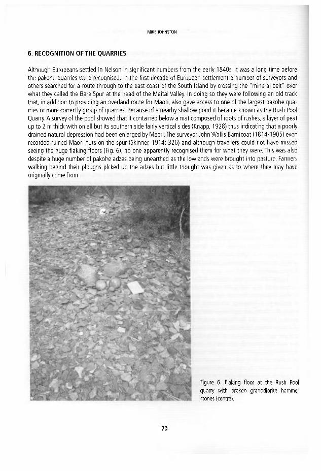
MIKE JOHNSTON
6. RECOGNITION OF THE QUARRIES
Although Europeans settled ¡n Nelson ¡n significant numbers from the early 1840s, ¡t was a long time before the pakohe quarries were recognised. In the first decade of European settlement a number of surveyors and others searched for a route through to the east coast of the South Island by crossIng the "mineral belt" over what they called the Bare Spur at the head of the Maltai Valley. In doing so they were followlng an oíd track that, In additlon to providlng an overland route for Maori, also gave access to one of the largest pakohe qua-rries or more correctly group of quarries. Because of a nearby shallow pond It became known as the Rush Pool Quarry. A survey of the pool showed that It contained below a mat composed of roots of rushes, a layer of peat up to 2 m thlck with on all but Its southern side falrly vertical sldes (Knapp, 1928) thus Indicatlng that a poorly dralned natural depression had been enlarged by Maorl. The surveyor John Wallls Barnlcoat (1814-1905) even recorded rulned Maorl huts on the spur (Sklnner, 1914: 326) and although travellers could not have mlssed seeing the huge flaklng floors (Flg. 6), no one apparently recognised them for what they were. This was also despite a huge number of pakohe adzes being unearthed as the lowlands were brought Into pasture. Farmers walklng behind thelr ploughs plcked up the adzes but llttle thought was glven as to where they may have orlginally come from.
Figure 6. Flaklng f loor at the Rush Pool quarry w i th broken granodior i te hammer stones (centre).
7 0

P A K O H E - A ROCK THAT FIJSTAINFD FARIY MAORI SOCIETY IN NEW ZEALAND
One person who would have done so was the Germán geologist Ferdinand Hochstetter (1829-1884) who ¡n 1859 was given leave from the Austrian Novara Expedition to remain ¡n New Zealand, initially in Auckland Province in the North Island and then in Nelson. In New Zealand, Hochstetter was accompanied by Julius Haast (1822-1887), another Germán geologist. During their travels Hochstetter acquired a number of adzes, some of which he illustrated in his books (e.g. Hochstetter, 1867: 66). Both men in September 1859 visited Dun Mountain at the head of the South Branch of the Maitai River to examine the copper and chromite deposits and during which they observed mudstone that "is grey, cherty and fractured into small pleces". Hochstetter goes on to state that the "whitish-grey blocks of this rock are widely visible between the rusty yellow, serpen-tinous rocks (Fleming, 1959:233). Hochstetter correctly interpreted that the rocks are "argillite inciuded in the serpentinite and altered". Because the rocks were not as altered as at some other iocalities, such as the Rush Pool only 3 km to the north, they have never been worked by the Maori and consequently Hochstetter did not make the connection between the "mineral belt" and the adzes.
During their visit to Dun Mountain, as well as elsewhere during their two month stay ín Nelson, Hochstet-ter and Haast were accompanied by a number of Nelson's leading settlers, who were also keen naturalists, as well as the geologist Thomas Ridge Hacket (1827-1884), local manager of the Dun Mountain Copper Mining Company. It is certain that if any of these men had been aware of the quarrying they would have informed Hochstetter who would have insisted that a short detour was made to the Rush Pool. Hochstetter did, however, recognise that part of Dun Mountain was not serpentinite but almost puré olivine that he named dunite. Haast carne doser to seeing the evidence of quarrying for a few weeks after the Dun Mountain visit he was returning from, on behalf of Hochstetter, mapping the area east of the mountain and actually descended the Bare Spur on his way to Nelson. Unfortunately, by the time Haast and his companions reached the Rush Pool dusk was descending and they hurried on without stopping. Two years later the track was rerouted a little farther to the north and the one up the Bare Spur fell into disuse.
While Hochstetter and Haast were unfortunate not to come across the pakohe quarries on the Bare Spur, it is possible that a number of those in east Nelson were rediscovered soon after. In 1862 the Dun Mountain Copper Mining Company, formed to mine what later proved to be non existent copper lodes in the "mineral belt", dlrected its attention to extracting the chromite instead and the first Iarge exports commenced from near Dun Mountain in 1863. While the demand for chromite remained high the search was on for other deposits elsewhere in the belt and it is possible that pakohe workings in the vicinity of several chromite prospects that had been found were recognised about this time. Certainly when there was a brief revival of Interest in chro-mite in the late 1870s, following the discovery of a process of using chromíum salts in the tanning of leather, several zones of mineralisation were found adjacent to significant pakohe workings, such as at Red Hill (John-ston, 1987). However, if quarries were found during these periods of prospecting, as seems likely, no record of them was made. In addition to the activities of the miners and prospectors, the hill country fringing the eastern ranges were being surveyed for settlement and as farmers deared the vegetation, most commonly by burning, and hunted for wild pigs in the areas that were not torched, quarries were noticed and became more widely known. One such quarry in the Whangamoa Valley is now known as Hebberd's after the landowner (Wastney and Wastney, 1982:11-12). Also many Nelson citizens had a pakohe adze sitting on the mantelpieces in their homes, and a few had made extensive collectíons, such as Edwin Herbert Lukins (1861-1931). However, It ap-pears that such collectors were more interested in the finished articles rather than their origins.
There were, however, others who took a keen interest in natural history and were frequent visitors to the tillls containing the "minera! belt". Frederlck Giles Gibbs (1866-1953) was born in London and was ten when he arrived in Nelson. After graduating he taught at Nelson College before being appointed as headmaster of Nelson Boys' Central School. From an early age natural history frequently took him into the Neison hilis. In
7 1

M I K - JOHNSTON
particular, his love of botany meant the "mineral belt" held a double fascination, its unusual rocks giving rise to its unique vegetation. Undoubtedly the Bare Spur would have been visited frequently and in the early 1900s he and fríends bu i It a hut on the banks of the nearby North Branch of the Maitai River (Mann, 1977). He later wrote the botanical section of the "Geology of the Dun Mountain Subdivisión" {Bell et al., 1911). Another teacher in Nelson who had similar interests to Gibbs was Frederick Vincent Knapp (1863-1945) and the two had also cióse professional ties as Knapp was for a time first assistant at the boys' school. However, Knapp's forte was Maori artefacts, particularly those that were not polished. Starting at an early age he amassed over his life time a huge collection that was dominated by unpolished pakohe woodworking tools and for which he attempted to interpret their use. Again Knapp in his younger years would have been no stranger to the Rush Pool and probably several other quarrles. After his retirement In 1922 from the headmastership of the Nelson Girls' Central school he published a number of papers on the tools used by the Maori (Skinner, 1946).
Just when the existence of the quarries became known beyond Nelson is uncertain but in 1897 Captain Frederick Woilaston Hutton (1836-1905) director of the Canterbury Museum in Christchurch gave a presenta-ron to the Philosophical Institute of Canterbury on Maori stone implements. Hutton was an outstanding sci-entist who was a Fellow of the Royal Society and had, after a short spell in the British Army, spent much of his career with the New Zealand Geological Survey before taking on a more academic role. In his presentation Hut-ton made a fleeting reference to the stone-irmpiement quarries in the South Island, including those in Nelson (Hutton, 1897: 130). By now ethnology as a research subject was firmly established following the founding of the Polynesian Society in 1892, largely through the efforts of Stephenson Percy Smith (1840-1922), Percy Smith was born in England and arrived wi th his family in New Zealand In 1849 where they farmed in Taranaki in the west of the North Island. He became a surveyor, an occupation that f i t ted in well with his interest in all things to do with natural history as well as bringing him into contact with Maori in remote bush areas and whose contact with Europeans had been minimal. This kindled an interest in ethnology and, although he became Surveyor-general for New Zealand, it is as an ethnologist that he is now largely remembered (Byrnes 1993). Another with similar interests was Eldon Best (1856-1931), who as a member of the Armed Constabulary in the bush regions of Taranaki had first met Smith. He later accepted Smith's invitation to join the Polynesian Society. These two men, more than any others, firmly established ethnological studies in New Zealand. Despite authoring a major publication that appeared in 1912 on the stone implements used by Maori, Best only gave the pakohe quarries a fleeting reference.
The credit for the first detailed account goes to Henry Devenish Skinner (1886-1978), who in March 1910, presented a paper to the Otago Institute on the Rush Pool quarries (Skinner, 1914). Skinner, who had devel-oped a fascination for Maori culture a ta very early age from his father William Henry (1857-1946) a Taranaki surveyor. Skinner sénior had spent most of his life in the province of his birth and, in doing so, gained first hand experience of Maori people living in a society yet to be markedly influenced by Europeans. He was a founding member of the Polynesian Society. His son quickly broadened his interest in ethnology and became aware of the Rush Pool when a boarder at Nelson College from 1902 to 1905. Although he qualified as a lawyer he decided on a career path more attuned to ethnology and when the family of his future wife moved to Dunediri, Skinner followed and it was there that he gave his paper to the Otago Institute. By the time it was published in 1914 he was acting curator of the University of Otago Museum and his eventful career culminated in his appointment to the directorship of the Otago Museum. Although Skinner observed at the Rush Pool granodi-orite hammer stones, ranging from pebbles to boulders up to 25 kg in weight, it is likely that the presence of the pool, which he regarded as artificial, was instrumental in hlm postulating that a key part of the quarrying process was for an intense fire to be lit against a face and then rapidly cooled by water thereby fracturing the generally massive rock.
7 2

r f - \ l \Vl IL tt I I IMI JIJJIHIULU1 L-^IM-I IVI^l^MU II1» IML.Vil í-L^lLMI1»^
Five years after Skinner's paper was published another descriptlon of a pakohe quarry, this time one on the southern end of D'UrvIlle Islarid, was forthcoming by James Alian Thomson (1881-1928), a geologist spe-ciallsing in paleontology, and an exceptional man of science. After various positions, including with the New Zealand Geological Survey, he wasappointed director o f the Dominion Museum inWellington. Still enthusiastic for fieldwork, he on the encouragement of Elsdon Best, who must have at the very least been advised of its presence, visited O'Urville Island where he was guided to the quarry by a farmer. Although finding no evidence of fire, Thomson accepted Skinner's inference that this was how the rock was quarried. More significantly, he observed that there were a large number of pieces around the quarry that, while of suitable size for making into tools, had been rejected. From this he inferred that they were of unacceptable quality and were from a superficial layer, up to about 0.3 m thick, of more weathered rock that had endosed the better material (Thomson, 1918).
It was not until 1946 that the next report on the quarrying of pakohe appeared following an investigaron by Roger Shepherd Duff (1912-1978) oí the Hebberd's and Oakley's quarries in the Whangamoa Valley, inter-medíate between the Rush Pool and D'Urville Island (Duff 1946). Duff, who was a student of Skinner's, was the ethnologist at the Canterbury Museum (two years later he was its director). Like Thomson, the local farmers showed Duff the quarries, which were well exposed on land cleared of forest for grazing (following reforesta-tton in the late 20,h century the quarries are now overgrown and difficult to access, let alone observe). At the quarries, granodiorite boulders, probably from Cable Bay, of similar dimensions to those at the Rush Pool were present. This, and the lack of any evidence of the use of fire in the quarrying and that most importantly fire would have a deleterious impact on rock quality, led Duff to argüe that use of granodiorite boulders as ham-mer stones was the solé method of obtaining suitably sized pieces of pakohe. Duff thought that the boulders would have been hurled from a high point at the rock below, but it seems likely that more controlled impact was ¡nvoked, such as having the boulder in a sling suspended from some form of gantry. The oval shape of the boulders would be consistent wi th such a practice. Since the pioneering descriptions of Skinner, Thomson and Duff a number of archaeological and ethnological studies have been completed (e.g. Jones, 1984; Keyes, 1975; Wellman, 1962), although much still remains to investígate. Unfortunately, the potential for getting a fuller understanding of this major industrial enterprise, particularly its early history, appears to be limited.
ACKNOWLEDGEMENTS
The writer is indebted to Steven Bagley, Department of Conservation, Nelson, for helpful discussions concer-ning the use of pakohe and on historie Maori culture generally as well as, along with David Smale of Nelson, for critically reviewing the manuscript.
REFERENCES
Beck, R. J. and Masón, M. 2002. Mana Pounamu - New Zealand Jade. Reed, Auckland, 184 pp. Bell, J. M., Clarke, E. de C,, and Marshall, P. 1911. Geology o f t h e Dun Mounta in Subdivisión, Nelsori. N.Z. Geological Survey
Bulletin, 12. Byrnes, G. S. Í 993 . Smith, Stephenson Percy 1840-1922. D /c t / ona r /o f WewZeafanc/Bíogirap/ iyí , 470-471. Br idgetWi l l iams
Sooks: Department of Internal Affairs. Challis, A. J. 1978. Motueka An Archaeological Survey. New Zealand Archaeological Association Monograph 7.
7 3

MIKE JDHNSTON
Challis, A.J, 1991. The Nelson-Mar lborough Región: An archaeological syntbesis. New Zealand Journal of Archaeology, 13, 101-142.
Duff, R.S. 1946. Native Quarries of Baked Argi l l i te (N.Z.). Records of the Canterbury Museum, 5(2), 115-124. Fleming, C.A. 1959 (Translator and editor). Geology of New Zealand: Contributions to tbe Geology of the Provinces of
Auckland and Nelson byFerdinand von Hochstetter. Government Printer, Wel l ington, 320 pp. Hochstetter, F. von 1867. New Zeaíand - its Physical Geography, Geology and Natural History with special reference fo the
results of Government Expeditions in the Provinces of Auckland and Nelson. J.G. Cotta, Stuttgart, 515 pp. Hutton, F.W. 1897. On Maori Stone Implements. Transactions ofthe New Zealand Institute, 3 0 , 1 3 0 - 1 3 4 . Johnston, M. 1987. High Hopes - The History of the Nelson Mineral Belt. Nikau Press, Nelson, 152 pp. Jones, K.L. 1984. Polynes an quarryíng and f lak ing practices at Samson Bay and Fails Creek argil l i te quarries, Tasman Bay,
New Zealand. World Archaeology, 16(2), 248-266. Keyes, I.W. 1975. The D'Urvil le Island-Nelson metasomatised rocks and their signif icance in New Zealand prehistory. Histó-
rica! Heview (Whakatane and Dístríct Histórica! Society), 2 3 , 1 - 1 7 . Knapp, F.V 1928. Report on research at the Rushpool on the Oíd Maungatapu Track from Nelson to the Pelorus. Unpubl is-
hed report held by Nelson Provincial Museum (NPM2008.33 C. 1.8). Leach, H. 1990. Archaic adze quarries and work ing floors: an historical review. The Journal ofthe Polynesian Society, 99,
373-394. Mann, S. 1977. F. G. Gibbs - His ínfluence on the social history of Nelson, 1890-1950. The Nelson Historical Society, Nelson,
206 pp. Rattenbury, M.S., Cooper, R.A. and Johnston, M.R, 1998. Geology ofthe Nelson Area. Institute of Geological & Nuclear
Sciences 1:250 000 geological map 9. Reed, JJ. 1959. Soda metasomatised Argil l i tes associated wi th the Nelson Ultramafic Belt. New Zealand Journal of Geology
and Geophysics, 2(5), 905-915. Skinner, H.D. 1914. An andent Maori Stone-quarry, Transactions ofthe New Zealand Institute, 46, 324-329. Skinner, H.D. 1946. Obituary Frederick Vincent Knapp 1863-1945. The Journal of the Polynesian Society, 5 5 , 8 1 - 8 2 . Thomson, J.A. 1918. Maori Rock-quarr ieson D'Urvil le Island. New Zealand Journal of Science and Technology, 1, 321-322 . Walls, J.Y. 1974. Argi l l i te quarries of the Nelson Mineral Belt. New Zealand Archaeological Association Newsletter, 17(1),
37-43. Wastney, PV, and Wastney, N.L. 1982. Roads ofYesterday. Whangamoa, Wakapuaka and Maungatapu. Nelson, Stiles. 83 p Wellman, H.W. 1962. Maori Occupation Layers at D'Urvil le Island, New Zealand. N e w Zealand. Journal of Geology and
Geophysics, 5(1), 55-73.
7 4

J. E. Ortiz, 0 . P iche, I. Rábano and L. F. Mazad lego (eds.) Hiaory of ñeseanb inM<ne/a'/teources. Cuadernos del Museo Geominero. 13. Instituto Geológico y M 'nero de España, Madr id. ISBN 9 7 8 - 8 4 - 7 8 4 0 - 8 5 6 - 6 © instituto Geológico y Minero de España 2011
THE ALMADÉN MERCURY MINING DISTRICT
Pablo L. Higueras Higueras1, Luis Mansilla Plaza2, Saturnino Lorenzo Álvarez2 and José María Esbrí Víctor2
Instituto de Geología Apl icada, Universidad de Cast'9a-La Mancha. Pl. Manue l Meca 1, 13400 A lmadén (Ciudad Real}, Spain. pab lo .h igye ras0udm.es A l m a d é n School of Mines, Universidad de Castil la-La Mancha.
Abstract . The Almadén mining d is t r ia includes theWor ld 's largest mercury mine, exploited in a practícally continuous way since Romans times unti l the dosure of all the mines and metallurgic dependencles at the 1990's and the 2000's. In this work w e summarize the most relevant informa-ban about the mining geology of the district, as well as the history of mercury and the Almadén mine. Final concerns include a compllat ion of the actions carried out to preserve the rich local mining heritage, funded and realized by different instances, such as the Almadén School of Mines (Escuela Universitaria Politécnica de Almadén, UCLM), the mining company (Minas de Almadén y Arrayanes S.A., MAYASA), and the regional qovernment (Consejería de Educación y Cultura, Junta de Comunidades de Castilla la Mancha). A l t these action have implied a valor izaron of the heri-tage resources for tourism, as well as a preservation of the knowledge of the mining area history.
1. INTRODUCTION
The Almadén mercury mining district correspondswith a Hercynian structure of the Iberlan Massif, theAlmadén Syndine. The Iberian Massif can be subdivided in a series of Zones, and the Almadén syndine is part of the lar-gest Zone, the Central Iberian Zone, being located on its South area (Figure 1). The syncline comprises Palaeo-zoic (meta)sedimentary and magmatlc rocks, including Ordovlclan (Tremadocian) to Late Devonlan (Fametian) shales and quartzltes, as well as the (meta)magmatlc rocks, characteristic of this structure, and corresponding to basalts and mafic pyroclastic rocks, with minor mafic intrusive (dolerítes) and even mínor intermedíate to felslc effusive difieren dates (quartzandesítes, rhyolites) (Higueras et al., 1991). On the other hand, the most in-teresting feature of the Almadén syndine is to be the host of the World most important mercury mining district, comprising not only the huge mine of Almadén, but also 5 more mines of less importance, and up to 60 points where the presence of cinnabar (HgS, the main mercury ore) has been described.
2. LOCAL GEOLOGY
The geology of the area can be described, in simple terms, as a Hercynian syncline of Palaeozolc rocks restlng unconformablly on Pre-Ordovician rocks of the so-called "Complejo Esquisto-GrauváquIco" (CEG). A brief des-criptlon of these features follows.
The Preordovician basement (CEG) corresponds to (meta)shales and greywacke, constltutlng a thick and homogeneous complex, probably affected by a Pre-Hercynian tectonic event of late Precambrian age (Cado-mian). These materials can be found both North and South of the syncline structure, at the Valdemanco and
: Valle de Alcudia anticlines, respectively.
7 5

PABLO L. .HIGUERAS HIGUERAS, LUIS MAN5ILLA PLAZA, SATURNINO LORENZO ÁLVARFZ AND JOSÉ MARÍA ESBRl VICTOR
Biialti Uppe rVbbaieGmip
Base quartiite Las Cue\as quartzite
Cría dera quartzite
Subiclcanre p~ , í I thcteiites L-^-J ^ « ^ « h ™ ^ S i ®
íücesaons Interiné di* e & addic 10 .1
"1 Canteras quartzite \ ' ^ o J S H * 3
3
He? pe rían M¿S$Íf
' W J
Devonian iiiFisa .Silurian [ [ Ordov'ieian f i Precambriarj ,'flS Main Hg deposits iB Entredicho
Amorican quartzit?
Figure 1. Location and geological sketch map of the Almadén syncline, w i th indication of the main Hg deposits.
Palaeozoic succession corresponds to an almost complete stratigraphic series comprising Early Ordovi-cian (Tremadocian) to Late Devonian (Fametian) (meta)sediments mostly of detritic origin. Middle Devonian is absent at this sequence, and minor carbonate rocks, of Ashgilian age, are exceptions to this general descrip-tion. Another exception to note is the presence of magmatic rocks, forming layers and sill-type intrusions all along the stratigraphic section, although they are more frequent among Silurian rocks, and much more among the Devonian sequence, that can be described as volcano-sedimentary. The sedimentary record includes four major quartzite formations, named as Armorican Quartzite (Arenigian), Canteras Quartzite (Llandeilian, or Dobrotivian in the modern nomendature), Criadero Quartzite (Upper Hirnantian-Lower Llandovery) and Base del Devónico Quartzite (Siagenian). To note again is the Criadero quartzite ñame, after the presence of the cinnabar orebodies (Criadero means ore deposit).
Magmatic rocks present in this stratigraphic record inciude mafic volcanic rocks (mainly metabasalts, but also minor outcrops of differentiated volcanic rocks, such as trachytes, trachyandesites and rhyolites), as well as pyrociastic rocks (the so-called Frailesca, local ñame derived from its aspect similar to the habits of monks, frailes in Spanish). Also relatively frequent are sills of mafic dolerites. Especially ¡nteresting are the Frailesca pyrociastic rocks, formed by basaltic fragments in a silicidastic matrix, and incíuding occasionally ultramafic fragments. These rocks forms diatrema-like structures hosted in the (meta)sedimentary rocks all along the stratigraphic sequence, although they are specially frequent in Silurian and Devonian rocks, and they have been interpreted as genetically linked to the origin of the mercury deposits, being present in most of them, and particularly in the largest ones,
Tectonic deformation includes folding, causing the general structuration of the area, with asymmetric anti-clines and syndines with south limb almost vertical and north límb dipping among 30 and 45°.These structures are also affected by faulting, corresponding to several arrays, and produclng horizontal displacements of up to several kilometers with minor vertical components.
7 6
I H ; ALMADÉN MfcRCURY .MINING DISIRICf
Granitic ¡ntrusions are also present ¡n the syncline, but not In the Almadén rnercury mining area. A small basin filled by sands and boulders sediments of Carboniferous age is present at the syncline nu-
cleus area. The area is actually subject to erosión, and crossed by Valdeazogues (meaning mercury valley, after the
Arab ñame for mercury, Azogue) River, tributary of the Guadiana basin. General geomorphologic pattern of the area corresponds to an Appalachian rellef, with sierras over the quartzite formations and valleys on shales formations, with máximum topographic differences reaching 350-400 m.
3. GEOLOGY OF THE MERCURY DEPOSITS
As above stated, Almadén is not just its huge mercury mine, but a District comprising also a number of smaller deposits, exploited to lower or larger extend though history, as described in Chapters III and IV of this work. Here we describe the main geologic features of the main mines of the district.
After the main geologic studies carried out in the district (Saupé, 1973, 1990; Hernández, 1984; Borrero & Higueras, 1990; Hernández et al., 1999), the mercury mineralization comprised in the Almadén mercury mining district can be subdivided, from the geological point of view, in two types; stratabound deposits, hosted in the Criadero Quartzite, and eplgenetic deposits, hosted in any Palaeozoic formations of the syncline. The first type can also be named as Almadén type, and includes the Almadén and El Entredicho mines, and possibly also the Vieja Concepción mine, The second, or Las Cuevas type, is a non perfectly homogeneous group of deposits character-ized as a whole for the presence of cinnabar as fracture/veins fillings in the (meta)detritic rocks and replacements guided by veins systems in magmatic rocks, Main mines of this second type are Las Cuevas, Nueva Concepción and Nuevo Entredicho, as well as the smaller mining sites of Corchuelo, Guadalperal or Las Tres Hermanas.
Almadén mine is the world's largest mercury mine. It has produced about 7,5 million flasks (commercial unit for mercury quantity, corresponding to 34,5 kg of the metal, usualiy bottled in stainless steel containers —flasks—, of 2,51 of capacity), meaning around 260,000 t of mercury. This represents more than 90% of the Distrid production, and almost one third of the total worid's historie mercury production. Cinnabar mineraliza-tion appears as a dissemination in three quartzite horizons, affected by the complex local tectonic deformation, and so it is divided in two branches: North branch, exploited from surface to some 250 m deep, and the South branch, exploited from some 50 to 550 m deep. These branches are separated by a tectonic accident, the so cal led "falla Meridional" (Meridional fault), as well as by the presence of a diatreme of the Frailesca rock (Fig-ure 2). North branch was exploited from the origins of the mine to 1755, when a fire stopped the mine activity for several years. After that, this branch was abandoned until the 80's of the 20th Century, when a deeper part of this branch was discovered and exploited until 2004, date of the final closure of the mine. It consists in a fragment of a fold pinched by the Meridional fault, and includes two mineralized horizons, almost vertical, with some 200 m in length and some 300 m in height. South branch was discovered in 1697, and exploited until 1998. It consists in a second fragment of the main mine fold pinched by the Meridional fault, and includes two mineralized horizons of orebodies: San Pedro at the so called " Cuarcita inferior" (footwall quartzite) and San Francisco and San Nicolás orebodies, at the "Cuarcita superior" (hangingwall quartzite).The orebodies extend some 300 m in length and some 550 m in height, they are some 5 m thin as an average, and they contain the /cinnabar dissemination with an average content of 5% Hg. Some minor folds and a number of dextral faults iaffect the general structure described.
-. El Entredicho open pit can be considered as a "scale model" of Almadén, also with a main fold and ;ia central fault dividing the deposít, as well as a Frailesca diatreme cutting the Criadero Quartzite (Figure 3).
7 7

PABLO L. .HIGUERAS HIGUERAS, LUIS MAN5ILLA PLAZA, SATURNINO LORENZO ÁLVARFZ AND JOSÉ MARÍA ESBRl VICTOR
Figure 2. Geoiogicai sketch map of the Almadén mine, at the 7st mining level.
Here the orebod :-» are only two, an Upper one equivalent to San Francisco + San Nicolás at Almadén, and a Lower one, equivalent to San Pedro in Almadén. Again these quartzite levels hosts the cinnabar dissemination (Figure 4), in this case with an average Hg content of 3%, which persist some 100 m in length and some 80 m in height. In this case it is clear than the mercury contents in the quartzite orebodies decrease away from the Frailesca diatreme. Mines reserves are in the order of 250.000 flasks.
Las Cuevas mine belongs, as previously said, to a different geoiogicai model. Mineralization is located in a higher stratigraphic level, and most of the ore is hosted by volcanic rocks, not only of Frailesca type. After Higueras et al. (1999) it can be interpreted as an epigenetic mineralization, constituting two subvertical and column-like orebodies, with some 100 m height and some 25 m diameter. Cinnabar appears as discontinuous vein fillings and disseminations replacing volcanic rocks and clasts of the Frailesca rocks (ure 5). Mined reserves are in the order of 180.00 flasks, and the mine was in activity in Romans times, and from 1983 to 2001.
La Nueva Concepción corresponds also to an epigenetic mineralization, different in many aspects to that of Las Cuevas. In this case the orebody corresponds to a dissemination of replacement typology affecting a series of magmatic rocks that only can be interpreted as dikes cutting the Criadero Quartzite (Figure 3). Cin-nabar dissemination is very rich in the area next to surface, where the magmatic rock forms a quite Iarge massif hosted in the Criadero Quartzite, and depletes downward, where the magmatic rocks constitutes a couple of dikes some 5 to 10 m thick hosted in the footwall shales formation.The mine was discovered in 1698, had a main exploitation period between 1702 and 1860, and later it was subject of a couple of intents of reactiva-tion, but the deep mineralization was too poor. Total mined reserves can be estimated in 150.000 flasks.
Vieja Concepción mine was exploited during the 17th Century, and it was never again recovered, so information regarding its geology is very scarce. After drill holes data, it seems to be an Almadén type minerali-zation, also hosted in Criadero Quartzite. Mined reserves can be estimated as less than 100.000 flasks.
7 8

THE ALMADÉN MERCURY MINING DISTRICT
Figure 3. Geological sketch map of La Nueva Concepción Hg mine
Figure 4. Criadero Quartzite w i th the cinnabar mineralization.
Figure 5. t f f - E í e v t f nimeializatüsn, w i th a massive cinnabar ve„ , (to the left) and cinnabar replacement at Frailesca dasts.
Nuevo Ent red icho was discovered in the 80's by means of drill holes, looking for a different possibility to thj North of El Entredicho mine. After this drill hole data is seems to be a small mineralization with extrernely high cinnabar contents, hosted by Frailesca rocks. It was planned to exploit it, but a reinterpretation of its size and the low mercury pnces did it non-viable.
A general and striking feature of all these mineralizations is their monoelemental character: meicurv is an element that is usually found together with others, including As, Sb, Ag, Au, or even platinum group elements, j í .U i'dria). However in Almaaén tnere are not other elements Dut mercury at the mineralizations. Even pyrite,
SnC iWiM B
LEGEND
P U W mlormwk B LowarOujtaM [ Foomt (Mun
n
*
7 9

PABLO L. .HIGUERAS HIGUERAS, LUIS MAN5ILLA PLAZA, SATURNINO LORENZO ÁLVARFZ AND JOSÉ MARÍA ESBRl VICTOR
the most common sulphide accompanying other sulphides in most types of base metáis deposits, ¡s relatively scarce in Almadén type mineralizations, although it is quite abundant in other ones belonging to Las Cuevas typology.
The origin of the mineralizations ¡s subject of controversy, between sdentists defending an origin linked to mercury extraction from shales formations (Saupé, 1973, 1990) and sdentists defending a deep origin, related to transport of the mercury from the mantle by the magmatic activity (Higueras, 1995). in both cases, mercury should have entered and disseminated in the "Criadero Sandstone" previously to its transformation to quartzite.
4. MERCURY MINING HISTORY IN RELATION TO ITS APPLICATIONS
Mercury is a singular element, causing the interest of man, and also capable of being used in a number of applications.That has caused the Almadén mineralizations to be exploited contlnuously for over 2000 years, in particular at the Almadén area.
Prehistoric people were interested in the usage of cinnabar as red plgment. Red has always been consid-ered as a "noble" colour, and so the first known applications of mercury were In this form, and so it was used at mortuary paintings for kings. Ancient Chinese and Hindus already used cinnabar to colour the skin, as paint, as well as in ointments. The Hindus also believed in mercury's aphrodisíac propertles and Phoenidan already used It within the recovery of gold. Mercury has been aíso found In Egyptian graves (1600-1500 b.C.), whilst Romans and Grecians used it for medical purposes. However, there is no clear evidence of the usage or extrac-tion of cinnabar at Almadén during this period.
Romans were also interested In the red colour of cinnabar, and called it "vermli ion". Concrete applications of vermilion were wall paintings, women makeup, and togas staining. Romans exploitation of Almadén is well documented, being expressly mentioned by Pllny the Eider.
Arabs were especially interested in the liquid metal, as a component of thelr intent, through alchemy, of "transübstantiating" other metáis into gold.
Another ¡mportant application of the metal during mlddle ages was dlnic, being some of its compounds the only cure for syphills, as discovered by Paracelsus. During this period the mine, owned by the Spanish crown, was rented to diverse people, exploiting the ores In a very irregular form, trying just to get the máximum pro-duction without any plannlng for future or any security or health concerns.
The discovery of America in 1492 and the related discovery of the huge silver and gold deposits of México and Bolivla, among others, caused the largest impulse to the exploitation of cinnabar, related to the discovery of the so-called "método de patio", a process based on mercury amalgamación for the recovery of these metáis from thelr ores. The method was ¡mplemented by Bartolomé de Medina in México in 1550, and soon expanded throughout the world. Also, the discoveries of the posslbiiity of using this metal In thermometers, by Fahrenheit, and In barometers, byTorricelil, are ¡mportant milestones in the usage of the metal during this period. Mining in Almadén began to be the most ¡mportant business for the Spanish crown, and mining activity developed large y, producing a very ¡mportant need of miners and engineers, the formers from poor areas of Spain, the latter from Germany, in particular from Freiberg. These Germán engineers developed new exploltations tech-niques, and began to consider the health risks concerned in these woks. A part of the workers were prisoners and the rest were free people, but ¡n general they received an unhealthy treat, denounced by the writer Mateo Alemán In 1572. During this period, the mine was under the administraron of the Fuggers, ¡mportant Germán bankers, under the supervisión of the owner, stili the Spanish crown. The mine activity was frenetic, and only
8 0
THE Al MADÉN MERCURY MINING DISTRICT
stopped by floods and by fices, two of them very important ¡n 1550 and 1755, that lasted years, and caused changes in the usage of mine fortifications, from wood to brick fabric.
Another important impulse to the usage of mercury carne with the application of the metal to the chlor-aífcaí/ indtjstry, /n 1892, after the discoveries of Carstner-Fetlner. By then the risks related to the exploitation of mercury were very well know, and produced the reduction o f the working schedule for the Almadén mine work-ers to 8 days for month, alternating with other type of surface jobs. Mine was then under the administraron of the Roschild American bankers, until year 1921, when it passed to the direct administraron of a state owned organísm, later transformed into the state owned company Minas de Almadén y Arrayanes S.A. (MAYASA), in 1982. Other important applications of mercury and its compounds during this period include electric batteries and instrumentatlon.
In the 1970s it developed the important "Minamata incident", a poisoning with the extremely toxic com-pound methylmercury {[CH3Hg] ), produced at the Minamata bay area, in Japan, as a consequence of con-sumption of fish with high contents of this toxin, due to the release of it to the bay by a chemical industry produclng methylmercury as a by-product. The "incident" caused hundreds of deaths and thousands of af-fected by ¡llness and theratogenlc effects, and it was the beginning of the consideration of mercury as a "global pollutant". Mercury prices decllned severely in the international market, and the "ecological consciousness" developed in parailel to this and other environmental incidents. Mercury applications decllned, and at present there are worldwide legislation aimed to reduce the risks linked to the usage of the element, including the European Mercury Strategy, that will ban mercury and its compounds exports from Europe since March 2011. On the other hand, all these questions coincided with the extenuation of the Almadén district mines, forcing the closure of all of them between 1997 (El Entredicho) and 2006 (the metallurgical plant, working with cinnabar reserves since the closure of the lasts mines).
5. THE HíSTORY OF THE ALMADÉN MINE
Almadén is one of the oldest mines in the woríd. The first known mining resources in the area are mineral pigments from the numerous remaimng cave paintings, probably calcolitics which appear in the shelter of local quartzite mountain range (for example, in the so called Virgen del Castillo). Theophrastus of Efeso (372 BC-285 BC), Aristotle's favourite disciple, describes the esteemed cinnabar of Spanish origin, which takes us to a mining of at least 2,300 years of antiquity.
The municipality of Almadén was always identifíed with the ancient román settlement of SiSAPO; recent archaeological excavations have proved that this mining municipality is located near La Bienvenida, which lies further to the south. Nevertheless, numerous remains from the cinnabar mines of Las Cuevas, Guadalperal, Valdeazogues and Mina Vieja have been found in Almadén dating from that time. The Romans extracted cin-nabar because vermilion was commercialized all over the Mediterranean. Pliny the Eider already described the distillation of native mercury from cinnabar in pots.
During the Román Empire, the mines were exploited systematically (they belonged to the emperor) and since the fall o f the Román Empire the documented information is very limited until the VIII century (year 711) when the Arabic rule began in Spain, being the site property of the caliphs.
The arrival of the Arabs revived the mercury mining in Almadén with the introduction of a metallurgic method, the xabeca furnaces which were working until 1600 approximately, new words appeared, tools and the ñame of Almadén itself etc.
Another important legacy from that time, together with remains of long bunghole oiE lamps, tools and dif-
8 1
PABLO L. HIGUERA!) HIGUFRAS, LUIS MANSILLA PLA7A, SATURNINO LORENZO ÁlVAREZ AND JOSÉ MARIA ESBRÍ VÍCTOR
ferent goods found inside the first floors of the Almadén mine and the surroundings, ¡s the rich mining vocabu-lary (alarife, almijarero, etc.} whose culmination is Almadén itself which means "the mine". Besides the mining heritage, Almadén also has medieval castles like the Retamar castie in Almadén (it has been restored recently with a scenic viewpoint looking over Almadén), Aznaron in Chillón, Vioque in Guadalmez, etc.
During the XII century the Castilian Kingdom took the place of the Arable domination, the site was then controlled by the Spanish state with consecutive leasings to Catalonian and Genovese traders and merchants. The nnaín leasing was to a group of Germán bankers called Függer and lasted from 1525 to 1645.
The discovery of America marks a historical milestone to launch again Almadén mining, especially since the moment the process of silver and gold amalgamation was discovered by Bartolomé de Medina in 1554 in the city of Pachuca (México), turning a small village into a source of mining and industrial development.
The reverberation furnaces from the Fugger times (1600) and Alúdeles or Bustamante furnaces (Spanish in-dustrial archaeology jewel), brought from America to Spain, in what might be called a technological exchange, prevlously the xabeca furnaces were taken to America. These are good examples of the transformation the Almadén mine was going to suffer in that period.
Mercury was an exploitation hub of American predous metáis and the Almadén mine. "The crown jewel" which must be protected through mining precincts (Buitrones, Almadenejos, etc.) with emblematic gates such as Charles IV Gate. It is a neodassical work, dated in 1786, made with solid bare brick, which allowed a con-trolled access to the enclosure.
Mercury demand was high during the 16"', 17 thand 18,!l centuries. In the second half o f the 18* century the incorporation of new mining technologies, coming from Freiberg, Germany and the progressive mechanization of the workings increased the productive capacity, causing a significant change in mining exploitation with the introduction of new working methods (Testeros, Larrañaga, etc.). These changes also affected Almadén, and it may be said this wíll be the greatest and most brilliant urban period of the city.
Almadén shows in its morphology, a historical evolution, always related to the mine. The first trace is ap-proximately radius central, around Retamar castie, and it expresses dearly the connection between narrow and winding streets belonging to an Arable settlement, over an elevation. Later Almadén spreads out cióse to Buitrones precinct and San Teodoro shaft untll the 18th century when a linear expansión begins from the mine core, which proves an urban connection and a spatial subordination to this.
Almadén has a very important artistic and historical heritage, mainly from modern times; this is shown in the architectural pieces due to relevant mining and metallurgical settlement. ín this context, it is the 18'h cen-tury when the deepest trace was left in the Almadén real estáte and even in the nearby towns of Almadenejos and Chillón.
In general, these works from the 18tn century are characterized for the use of traditional materialsfrom the área (such as quartzite stone masonry, brick or tiles, ilex wood, Arabic tile and forge) the construction simplic-ity, is not opposed to regularity in the farades and rationality in inner spaces and lastly, the carefulness of the decoration by using enlightened ornamental elements in main fagades. We cannot talk of styles (baroque or neodassical features). These elements are arranged mainly in the fagade centre, covering the main house door or the main floor balcony.
In this coílection of historie buildings the "Bullf ighting ring" is one of the most interesting and singular places In Almadén, it is of great architectural and urban interest. This building has got a hexagonal floor, and the central bullring encircles elevated corridors in 2 floors which give shelter to 24 houses, shaping a mixture of bullring and room building of singular characteristics. The main entry is a wide gate with a projecting balcony (box for distinguished persons in the inner part) and impeccable ornamental top. The location of the building, next to the royal way, was of peripheral use at the beginning and principal nowadays.
8 2
T H F A I M A D F N MERCURY MIN 'NG DISTRICT
San Rafael Mining Hospital, is another singular building in Almadén, it is the first hospital in the worid to be built to treat miners suffering from hidrargirism and silicosis, due to poor ventilation in underground exploítations, mercurial vapor exposure, and silica dust inhalations, which caused high rates of Illnesses and deaths.
It was established in 1752 and it was for workers and relatives as well; the hospital opened in 1774, reacb-ing its highest activity in the 1780's and 1810's. It had L shape with wide corridors and vaulted wards for sick people and sanitary rooms, emphasis Is given to its sober fagade with a central balcony in which we can ap-predate in the upper part a steeple and a niche wi th an image of Saint Raphael archangel, the main entrance gate is flanked with 2 graceful pilasters. Inside this spacious building stands out the marble staircase which serves for vertical communication with great luminosity.
Mining Academy (1777), the most important building in Almadén ever, wi th great meaning for national and international mining teaching, it was the first Mining School in Spain and the fourth in the world, very im-portant engineers studied there, for example Fausto D'Elhuyar (he discovered wolfram) and Andrés Manuel del Río (he discovered vanadium). It is a two-storey building with basement and exits through a back door, It has 2 sections with classical fa<;ade made up of openings and pilasters with raised blocks of stone, In the fagade stands out the balcony with circular parapets,
Other singular building in Almadén is the Real Cárcel de Forzados, heir of the original jail for 16" cen-tury prisoners; it was built in 1754 for prisoners working in the mine. The design and project management of the building work were given to military engineer Silvestre Abarca, who put up a two-storey building around a central courtyard.
The building's ground floor was for the prison personnel and the first floor was for cells and dormitories. The building, also known as New Jail, was knocked down in 1968 and since then, there stands the new Polytechnic University School of Almadén.
Currently, the building's ground floor has been preserved (punishment cells), whose ruins have been recov-ered by means of a project and have been integrated in the building, now they are classrooms, offices, depart-ments and a museum belonging to our Polytechnic University School of Almadén.
But not only are the civil architecture related to the mines outstanding examples from the 1811 century in Almadén. There are also rellgious buildings of interest: San Sebastian church, in the Plaza de los Donates de Sangre, was built in that time. The San Juan's Chapel in the Plaza de la Constitución. The most repre-sentative religious building is the Nuestra Señora de la Estrella's church, located in Plaza de Jesús, it has got baroque and neoclassical elements and it was an oíd chapel devoted to Jesús Christ wi th great distinction. The temple has got a Latin cross shape, with a front which combines stone and bare brick wi th a covering of Arabic tiles.
The main gate's decoration with an open space with a round arch, framed by two pairs of Doric columns over elevated bases to support a decorated arquitrave.
In the 19th century, the Industrial Revolution brought new mercury applications and an increasing demand, which produced new technological changes, mining derricks is a good example. They represent the technologi-cal progress in the Almadén mining district; they were metallic with different extractive machinery systems. We have, from the oldest to the most modern:
* San Aquilino's shaft (19,h century) in San Teodoro's precinct, winch equípment and pulley system from that time.
* Number 1 shaft from Diogenes mine (19th century) in the courtyard of the Polytechnic University School of Almadén. It has got a winch set and pulley system.
* San Teodoro's shaft (20"' century), in the San Teodoro precinct in Almadén from the 1960's.
8 3

PABLO L. HIGUERA!) HIGUFRAS, LUIS MANSILLA PLA7A, SATURNINO LORENZO ÁlVAREZ AND JOSÉ MARIA ESBRÍ VÍCTOR
* San Joaquin's shaft (20lh century) in Buitrones prednct in Almadén. This shaft carne into service in 1961 with modern technoiogy from that time.
The Industrial and warllke mercury uses (fulminating and explosives) increased the demand ¡n the first half of the 20th century, causing Important changes reflected in the numerous industrial buildings of the mine:
* The bu i I di ng housing extractive machinery of San Aquil inos shaft. * The mercury warehouse. * Carpentry and forge warehouses. * Oíd metallurglcal chimneys. * The oíd power statlon located in the working neighborhood of Almadén and converted now in a sheet
metal workshop. * Pacific furnaces. * Instailatlons of San Miguel shaft. Later, the progressive substitution of mercury by other metáis In the chemlcai industry (chlor-, alkall, batter-
ies, fungicide, etc.) and the abandonment as strategic metal from an arms polnt of view causeci a sharp decline in the demand, becoming more accentuated In the 80's due to envlronmental pressures.
For the last 3 decades, the mining activity suffered a progressive recesslon in Almadén resultlng in a decrease in the number of workers, with important social and economical consequences for the munlcipality resulting In the dosure of the mining installations in 2003. This closure forced people to find out new alterna-tives for the area, diversifying the economical activity and finding out a revitallzation and ¡mplementation of its mining heritage, one of the most important elements for the future development of the area.
6. ALMADÉN MINING HERITAGE REVITAL1ZATION
Undoubtedly, the interest in the Almadén heritage has been shown In the great amount of research done In Spain and abroad, but it was in the90's when the concern to recover and preserve our heritage began.
The opening in 1985 of the "Francisco Pablo Holgado" mining and historical museum in the Polytechnic üniverslty School of Almadén (EUPA), constituted the first really serious concern for the Almadén heritage. It takes up 3 exhlbltion areas of more than 800 square rneters. The first area is the School's own courtyard, dedicated to big industrial archaeological elements especlally Derrick number 1 from Diogenes mine in the Valle de Alcudia.
The second area corresponds to a restored area of the cells of the Real Cárcel de Forzados (an oíd jall) from the 18th century and the thlrd area, divided in 2 sections, devoted to paleontology and mineralogy the former and the latter to Almadén mining history.
The whole area culminates In an exhibition room of 100 square meters and the School historical library from tlie 18th century. The museum has supported educational activities, and it is a revitalizing element in preserving the Almadén mining heritage.
In 1994 and 95 a team of the EUPA teachers and students prepare a thorough inventory of ethnographi-cal heritage elements in Almadén. This inventory served as base for a project for the Diputación Provincial de Ciudad-Real about "strategic planning of ecotourism in Valle de Alcudia" (future programs), these suppose future proceedings.
The prívate company, MAYASA, through a "Sociedad Turística Comarca de Almadén", will be other signifi-cant motive to go on with the process, and they will transmit the heritage richness of the area, creating its own spirlt and interest, which is little known in the area.
8 4

THE ALMADÉN 'vIERCURY MINING DISTRICT
The recognítion of the "Manifest for the Restoration of the Mining and Historical Heritage in the Almadén Area", that the Spanish Society in defense of the Geoiogicai and Mining Heritage, prepared with occasion of the first scientific session, in October 1996,, where it was declared of highly interest, for current and future generations, the preservaron and restoration of the mining heritage.
This Manifest, with more than 1000 collected signaturas, during the scientific session, from institutions and organisms and it was the final recognition of the collective consclousness of the Almadén citizens, in defense of an unknown legacy for many citizens.
1997 is a decisive year, it is when the regional authorities from Junta de Comunidades de Castilla La Man-cha, through the Consejería de Educación y Cultura asked the University of Castilla La Mancha to carry out a Project (Industrial and Mining route in Ciudad Real: Almadén area, Almodóvar del Campo and Puertollano), to know exactly the area possibilities to be declared World Heritage, together with other proposals from the same autonomous community (Quijote Route, Villages of the Black Architecture, National Park of Cabañeros and the Ritual Celebrations of Habeas Christi). The 1 S"n April of the same year, the Heritage National Commission accepted the proposal presented by the Junta de Comunidades. In this way, Almadén Mining Heritage became part of the 70 proposals Spain presented to the UNESCO in 1998 for the next 10 years.
In 1999 winds of change carne for Almadén, it was said that something was moving on related to Almadén heritage and we can see how restorations works begin such as the Bullfighting Ring restoration (building from the 18,h century, declared National Monument from 1973), the Bullfighting ring building is currently an impor-tant tourist spot with hotel, museums (tauromachy and ethnographic), restaurant and the possibility of being used for bullfighting and open-air performances. It was opened in 2003 and it was a success.
Minas de Almadén decided a t the end of 2000 to include in the renovatlon plan of the company, the recov-ery of the mining heritage, creating the Francisco Javier de Villegas Institution in 2001, with the aim of restoring the Minas de Almadén y Arrayanes, S.A. (MAYASA), historical heritage, promoting the historical and scientific knowledge of the mining exploitations to be known by everybody.
To carry out this project, in 2000, the Director Plan for the Parque Minero de Almadén was approved, be-ing an instrument to design, control and plan the metallurgical and mining transformaron of the Minas de Almadén installations in a Mining Theme Park, understood as a space for cultural transmission, education, and tourism of quality.
Turning on this plan to recover the mining heritage of MAYASA, the miner's hospital of San Rafael was the first building to be restored, it was dedicated to be the headquarters of the " Francisco Javier de Villegas" insti-tution and it kept the archives from 2003. The definitive dosure of the mines in 2002 led to the comprehenslve recovery of the installations according to this plan, worklng for several years in this project until it starts the dossier of considering it under the protectlon figure"fl/en de Interés Cultural del Conjunto Histórico Minero de Almadén" and the opening the 16,h January of 2008 of the Mining thematic park.
Together with the recovery works of the mining company, another institutions from Almadén went on working in the industrial heritage of this mining area, the Escuela Universitaria Politécnica de Almadén opens in December 2006 the Interpretaron Center of the "Real Cárcel de Forzados" and the Almadén Townhall wil l open a tourist information center located in the Bullfighting ring building.
All this work carried out for the last 20 years has been followed by several national and international organizations, which from 2004 showed Interest in declaring the Almadén mines part of the World Heritage. The creation of the ICOMOS-UNESCO chair in the Mining School of Madrid, had as main aim the support to get this objective and in the International Scientific Commlttee about Cultural Routes held in 2004 in Ferrol (La Coruña) by the Spanish ICOMOS National Committee it is clear the interest In the Almadén Mining in the Intercontinental RoyalWay.
8 5

PABLO L. HIGUERA!) HIGUFRAS, LUIS MANSILLA PLA7A, SATURNINO LORENZO ÁlVAREZ AND JOSÉ MARIA ESBRÍ VÍCTOR
There is a general interest ¡n the Almadén mining heritage, in 2006 ICOMOS-ESPAÑA, UNESCO-tCOMOS chair of the Mining School in Madrid, the Almadén Townhall and the Polytechnlc University School of Almadén gave the first steps to prepare the process of declarlng World Heritage by the Junta de Comunidades de Castilla La Mancha and the Ministry of Culture to develop the rlght thing to do. The final results of the study and the international meetings about the Mercury and Silver Route ín the Royal Intercontinental Way held In Almadén (November 2006) and San Luís Potosí (June 2007), since then, the Ministry of Culture commlssioned ICOMOS-Spain the preparstion of the dossier to present the candldacy of Minas de Almadén for world heritage together wi th San Luís Potosí, Huancavelica e Idría. Finally only 3 partlcipated. Huancavelica, due the earhquake which destroyed part of Perú in 2007 has siow down the work.
In September 2007 the first draft was submltted to the UNESCO In París, ¡n order to be checked and cor-rected before the final submission in January 2008.
The joint dossier is called "Mercury-silver binomial In the Intercontinental Royal Route. Almadén, Idria, San Luís Potosí", after the evaluatlon we expect to enter Minas de Almadén in the llst of World Heritage by June 2009.
Almadén longs for the decisión of its mines to be included in the llst of World Heritage to go on walking and searching a future tied to the mercury world.
"where the mercury vein fínishes, it appears a new one, the rich cultural heritage of the Almadén area, a vein where the works wll! go on after the opening to the public ofthe mine theme park, mining acaderny, Almadenejos mines... till the revaiue ofthe whole cultura! heritage tied to the mercury exploitation arisen through centuries in Almadén".
REFERENCES
Almela, A,, Alvarado, M., Coma, E., Felgueroso, C, and Quintero, I.. 1962. Estudio geológico de Región de Almadén. Boletín de Instituto Geológico y Minero cíe España, 7 3 , 1 9 3 - 3 2 7 ,
Bemaldez, F, and Rúa, R. 1861-62. Reseña sobre la historia, la administración y la producción de las Minas de Almadén y Almadenejos. Imprenta de la viuda de D, Anton io Yenes, Madrid, 338 pp.
Bleiberg, G. 1985. El in forme secreto de Mateo Alemán sobre el trabajo forzoso en las minas de Almadén. Tamesis Books Limited, Londres, 150 pp.
Betancourt, A. 1990. Memoria de las Reales Minas de azogue de Almadén. Comisión Interministerial de Ciencia y Tecnología, Madr id, 290 pp.
Bouyx, E. 1970. Contr ibut ion a l 'e tude des format lons ante Ordoviciennes de la meseta meridionale (Ciudad Real et Badajoz). Memorias del Instituto Geológico y Minero de España 73, 263 pp.
Borrero, J. and Higueras, P. 1990. Nuevos conocimientos sobre la Geología y Metalogénesís de los yacimientos de Mercurio de Almadén (Ciudad Real). Boletín Geológico y Minero, 101(6), 48-66 .
Borrero, J. and Higueras, P. 1991. Geología y génesis de las mlneralizaclones de mercurio asociadas a volcan itas básicas en el sector de Corchuelo (Devónico Superior del slnclinal de Almadén. Boletín de la Sociedad Española de Mineralogía, 14,117-124.
Castillo Martos, M. 1994. Minería y Metalurgia: intercambio tecnológico y cultural entre América y Europa durante el período colonial español. Muñoz Moya y Montraveta Editores, Sevilla, 503 pp.
Dobado González, R. 1997, Las Minas de Almadén y el monopolio del azogue y la producción de plata er> Nueva España en el siglo XVIII. Ediciones de la Universidad de Salamanca, Salamanca, 328 pp,
De la Escosura, L. 1878. Historia del tratamiento metalúrgico del azogue en España. Imprenta y fundición M. Tello, Madrid, 140 pp.
8 6

THE A L M A D É N MERCURY MINING DISTRICT
Gallardo, J.L, Higueras, P. and Mol ina, J.M. 1994. Análisis estratigráfico de la "cuarci ta de Criadero" en el sinclinal de Almadén. Boletín Geológico y Minero, 105 (2), 135-145.
García Fuentes, L. 1980. El comercio español con América 1650-1700. Universidad de Sevilla, 574 pp. García Sansegundo, J„ Lorenzo Alvarez, S. and Ortega, E. 1987. Memoria explicativa de la Hoja n° 808, Almadén. Mapa
Geológico Nacional, escala 1:50.000, 2° serie. Insti tuto Geológico y Minero de España, Madr id. Hernández, A., Jébrak, M., Higueras, P., Oyarzun, R„ Morata, D. and Munhá, J -1999 . The A lmadén mercury mining district,
Spain. Mineralium Deposita, 34, 539-548. •Higueras, P. 1994a. Procesos pefrogenáticos y de alteración de las rocas magmáticas asociadas a las mineralizaciones de
mercurio del distrito de Almadén. PhD. Thesis, Universidad de Granada, 270 pp. Higueras, P, 1994b. Modelización numérica de la alteración que afecta al magmat lsmo básico relacionado con las
mineralizaciones de mercurio del distr i to de Almadén. In: Rey, J., Martínez Frías, J. and Lunar, R. (eds.), Geología y metalogenia en ambientes oceánicos. Depósitos hidrotermales submarinos. Publicaciones especiales del Insti tuto Español de Oceanografía, 18, 21-30.
Higueras, P. Crespo, J.L. and Hernández, A. 1997. Historia de la mina de mercurio de La Nueva Concepción. In: Mansil la, L. and Fernández Barba, R.C. (ed.), Actas de la primera sesión científica sobre patrimonio minero metalúrgico. Colección Ciencia y Técnica, Ediciones de la Universidad de Castilla-La Mancha, 21 1-222.
Higueras, P., Morata, D and Munhá, J. 1995. Metamorf ismo de bajo grado en fades prehnita-pumpel ly i ta en las metabasítas del Sinclinal de Almadén. Boletín de la Sociedad Española de Mineralogía, 1 8 , 1 1 1 - 1 2 5 .
Higueras, P., Oyarzun R,, Lunar, R., Sierra, J. and Parras, J. 1999. The Las Cuevas mercury deposi t , A lmadén distr ict (Spain): Unusual case of deep-seated advanced argíllíc a l terat ion related to mercury mineral izat ion. Mineralium Deposita, 3 4 , 2 1 1 - 2 1 4 .
Higueras, P., Oyarzun, R., Morata , D. and Munhá, J. 2001 . Alkal ine mafic magmat lsm and huge mercury deposits: the Almadén (Ciudad Real, Spain) case. Boletín de la Sociedad Española de Mineralogía, 24-A, 171-172.
Lang, M.F. 1977. El monopolio estatal del mercurio en el México Colonial. Fondo de Cultura Económica, México, 383 pp. Lafuente, 1.2002. Esclavos por la patria. Ediciones Temas de Hoy, S.A., Madr id, 343 pp. Larruga, E. 1996. Memorias políticas y económicas sobre los frutos, comercio, fábricas y minas de España, con inclusión de
los reales decretos, órdenes, cédulas, aranceles y ordenanzas para su gobierno y fomento. Edición facsímile, Zaragoza, volumen 6, 376 pp.
Lorenza Alvarez, S. and Solé, J. 1988. La discordancia intraprecámbríca y la estratigrafía del precámbrico superior en el sec-tor suroriental del anticlinal de AbenójarTír teafuera. II Congreso Nacional de Geología, Granada, 115-118.
Madarlaga, C. et al. 1934. Reseña informativa sobre el beneficio de los minerales del establecimiento minero de Almadén. IX Congreso Internacional de Química Pura y Aplicada. Jomo III Química Inorgánica. C. Bermejo Impresor, Madrid, 236-248.
Mansilla Plaza, L. 1992. Almadén en América a través de las rutas del mercurio. Ediciones de la Universidad de Castilla la Mancha, Ciudad-Real, 162 pp.
Matilla Tascón, A. 1958-1987. Historia de las Minas de Almadén. Vol I y II. Minas de Almadén e Instituto de Estudios Fiscales, Madrid, 725 pp.
Menéndez Nava rro, A. 1996. Un mundo sin sol la salud de ios trabajadores de la minas de Almadén, í 750- 1 900. Universidad de Granada y Universidad de Castilla la Mancha. Granada, 318 pp.
Mira, M,, Ortega, E. and Rodríguez Pevida, L. 1987. Memoria explicativa de la Hoja n" 834, San Benito. Mapa Geológico Nacional, escala 1:50.000. 2* serie. Insti tuto Geológico y Minero de España, Madrid.
Ortega, E. and Hernández Sobrino, A. 1992. The mercury deposits o f t h e A lmadén syncline, Spain. Chronique de la Recberche Míníere, 506, 3-24.
Ortega, E. and González Lodeiro, E. 1986. La Discordancia intra-Alcudiense en el domin io meridional de la zona Centroibérica. Brevíora Geologica Asturica, 34, 27-32 .
8 7

PABLO L HIGUERAS HIGUERAS, LUIS FV'ANSILLA PLAZA, SATURNIND LOHENZOÁLVART/ A N 3 JOSÉ MARÍA ESBRÍ VICTOR
Ortega y Gasset, M. 1946. Minero-metalurgia general y de España. Librería Beltrán. Madrid, 378 pp. Palero, F.J. 1993. Tectónica pre-hercínica de las series infraordovícicas de! anticl inal de Alcudia y la discordancia
¡ntraprecémbrica en su parte oriental (Sector meridional de la Zona Centroibéríca). Boletín Geológico y Minero, 104(3), 227-242 .
Prior Cabaníllas, J. 2003. La pena de Minas: Los Forzados de Almadén, 1646-1699. Ediciones de la Universidad de Castilla la Mancha, Ciudad-Real, 115 pp.
Roldán Barbero H. 1988. Historia de la Prisión en España. Inst i tuto de Criminología de Barcelona, Barcelona. 256 pp. Sal illas R. 1913. La Cárcel Real de esclavos y forzados de las minas de azogue del Almadén y las características legales de
la penalidad utilitaria, Madrid, 27 pp. Sánchez Gómez, J. 2000. Minería y Sociedad en Europa y América. Siglos XVI-XIX. Aconcagua Libros, Sevilla, 471 pp. Sánchez Gómez, J. 1997. La savia del Imperio. Tres estudios de economía colonial. Ediciones de la Universidad de Salamanca,
Salamanca, 347 pp. Saupé, F, 1973, La geologie du gisement de mercure d 'A lmadén (provínce de Ciudad Real, Espagne). Sciencies de la Terre,
11, 342 pp. Saupé, F, 1990. The geology o f t h e Almadén mercury deposit. Economic Geology, 8 5 , 4 8 2 - 5 1 0 . Sobrequés, J et al. 2003. Congreso. Los campos de concentración y el mundo penitenciario en España durante la guerra civil
y el franquismo. Editorial Crítica. Barcelona, 296 pp. Suarez, A. (Coord.) 1976, Libro Blanco sobre las cárceles franquistas 1939-1976. Ruedo Ibérico. París, 312 pp. Zarraluqui, J. 1934. Los almadenes de azogue. (Minas de Cinabrio. La historia frente a la tradición). Librería Internacional
de Romo, Madr id, 516 pp.
8 8

I. E, Orfi2, O, Puche, Rábano and L, F. r / a z a c i e g a (eds.) tew/ sf ifaml< 'r. ifotraiteamB Cuadernos i » ¡ Museo Geaminero, 13, nst f tutc O e n l ó t j i f o y M ine ro ce E s p a ñ i , V l ad ' i d , 5 3 N 9 7 8 - 8 4 - 7 8 4 0 - 8 5 6 - 6
© Inst i tu to G e o l f i q k í y M ine ro de Fspoña 2 0 1 1
SPIRITO BENEDETTO NICOLIS DI ROBILANT (1724-1801) AND THE "THEORY OF MOUNTAINS AND MINES"
Ezio Vaccari
U n i v e i í i t i de ' Insobr ia, > p a r t i n e n t o d i I n k n n a i k a e Comur 'caz iorn , via M a z / i n i i , 21 " 0 0 Várese, Italy e z i a V 3 C f a r i @ u n i n s u b r a . i l
A b s t r a c t . The a im of this paper is to suggest t ha t Robilant's geological and mineralogical f ield-work was st imulated and enriched by impor tant elements oí his min ing expehence, such as prac-tica! knowledge of how underground masses are conf igured, skills in interpret ing rock structures contain ing minerals (inside and outside the mines), curiosity about regional landforms, and ha-bi tual tendencias favoríng the sketching of geo-mineralogical sections w i t h part icular a t ten t ion to the series of the strata. His f ie ldwork in the western Alps also provided essential data in order to out l ine a new " theory of mounta ins and mines" wh ich may be regarded as one of the late 1 Sth century 'dassi f icat ions' of mounta ins based on the study of l i thostrat igraphical features.
1. INTRODUCTION
During the 1 Sth century mining and mineralogical knowledge played a significant role in the process of the formation of the discipline of the geological sciences. Within this context, the importance of the interaction between geology and mining for the development of stratigraphy in Italy since the early 18th century, when mining background and experience, as well as interest in mining, were common elements among several Italian scholars who studled mountains and other terrestrlal reliefs paying particular attention to their rocks, strata and formations (Vaccari, 2000).
Spirito Benedetto Nicolis di Robilant was one of the most relevant Italian mining experts who became distinguished geologists in the second half of the 18th century (Vaccari, 2001; Laureti, 2002). His professional career did not form part of the academic context of the universities, but his technical and scientific activities, together with his impressive records of published and unpublished works, dearly show the extent of the 18th-century link from practical mining expertise and mineralogical knowledge to advanced research In geology. Robilant may be considered a 'famous unknown' in the history of geology, although most of his technical con-tribution to mining and metallurgy has been finally studied and made available by the long-awaited publication of the manuscripts and ptates of his main mineralogical travels (Robilant, 2001). However, most of his geologi-cal works, in particular related to the study of the Alps and mountain formations, still remain basically unknown with several manuscripts being housed inTurin (State Archive, Royal LibraryandAcademy of Sciences), together with the better known unpublished papers on mining and metallurgy Usted by Pipino (1999, pp. 178-180) and Garuzzo (Robilant, 2001, pp. 6-73).
1 1 3

EZIO VACCAR-
2. ROBILANT'S MINING STUDIES AND MINERALOGICA!. TRAVELS
Spirito Benedetto Nicolis di Robilant was born in 1724 in Turin from a noble Piedmontese family (Fig. 1). He attended the Ro-yal Artillery School, where he studied mathematics, mechanics, trigonometry, military engineering and some basic metallurgy (probably based on the treatises by Swedenborg and Réamur): geometry was the basis of all his studies and he was a very good student in these subjects. In 1747, at the end of the war of Austrian Succession, Robilant was nominated Captain of Artillery and one year later he travelled to the famous mining center of Freiberg in Saxony, leading a group of four cadets to take courses in metallurgy, mineralogy and chemistry as well as to study the organizaron and the productivity of the lo-cal mines (Marino, 1975). The travel had been ordered by the King of Piedmont and Sardinia, Cario Emanuele III, who had started at that time an ambitious program to restructure and modernize mining in Piedmont, also with the training of a spe-cialized group of mining technicians within the Royal Artillery and later the military Engineers. From 1749 to 1751 Robilant and four Piedmontese cadets stayed in Freiberg but also visited other mining areas in Bohemia, Hungary (Schemnitz), Carinthia, Styria and Tyrol. Robilant not only attended the scientific and
Figure 1. Robilant's portrait (in Robilant, 2001).
Figure 2. Furnaces for silver in Freiberg (in Robilant, 2001).
1 1 4

SPIRITO BENEDETTO NICOLIS DI ROBILANT ( 1 7 2 4 - 1 8 0 1 ) A N D THE "THEORY OF MOUNTAINS A N D MINES"
technical courses ¡n Freiberg, but also took part in some mining excavations in the Erzgebirge (mineral moun-tains) for compieting his practical apprentlceship. During this period he also met dlstinguished scientists such as the Germán chemist Christlieb Erhegott Gellert (1713-1795) who praised Robilant's knowledge in natural sciences, physics and mathematlcs (Gellert, 1750, Preface). The result of this travel was an enormous amount of technical (but not geological) information, eventually collected In six hand-wrltten volumes, wi th over 200 plates, mostly drawn on the model of the "planches" of the renowned Encyclopédie edited by Dlderot and D'Alembert (Fig. 2). This comprehensive report was presented as a completed work to King Vittorio Amedeo III In 1788, but was never published.
After his return to Italy, Robilant was nominated General Inspector of Mines, later Liutenant Colonel of the Artlllery and also became Director of the new mining school established in Turin in 1752 (Pipino, 1999). However, in spite of the attempts undertaken in order to ¡mprove the technical efficiency in metallurglcal and extracting processes (Micheletti, 1969; Pedrocco, 1975; Bulferetti, 1980) during the fol lowing years the general management and the productivity of the mines in Piedmont did not increase as had been expected. Several projects were outlined and proposed, in particular for the mines and the forges of the Aosta Valley (Nlcco, 1987-89), but only a few were actually completed. Consequently, most of the activities were interrupted by the Government in 1769 and in that same year Robilant resigned from the Army and from the office of General Inspector of Mines, in order to retire to prívate Iife and to scientific studies.
3. ROBILANT'S "THEORY OF MOUNTAINS A N D MINES"
During the fol lowing decades Robilant became quite active within theAcademy of Science of Turin, established in 1783, where he continued to work on mineralogical, lithological and chemical matters, often based on the results of his early f ieldwork: using data and observations collected from several journeys and mine ¡nspections, mainly in the western Alps during the 1750s and 1760s, Robilant published in 1786 a detailed Essai Géo-
graphique (Geographical Essay) on the territories of Piedmont, which formed part of the Kingdom of Sardinia. This included a "subterranean and mine-ralogical topography" wi th a large "topographlcal-mlneralogical" map drawn by Abbot Lirelll under Robílants' suggestlons (Robilant, 1786). This map (Fig. 3), which Robilant had assembled combining the results of his fieldwork wi th information collec-ted from local officers, represents an interesting and rare example of early Italian mineralogical car-tography. It is basícally a topographical map, wi th numbers from 1 to 505 indicating all the localities (towns, villages, mountains), as well as the active and abandoned mines, Usted in a separate Índex. Moreover, a series "caracteres chimiques", clearly taken from the alchemlcal symbols still used in the late 18th century chemistry, indícate the type of mi-neral ores, which include gold, silver, copper, iron,
Figure 3. "Car teTopographique Mineraiogique des Etats du ROÍ enTerre Ferme" (in Robilant, 1786).
f> r ,L •
« .. T • • • -_ • r *.M ¿
i f f / ' v i : ¿ í & b :
-..•ti- .- --+S. i - J V ' / j j , H." ' r . . - j
- í V : • • ' r ' y . - ^ y ' ' - '
' • í t * ( *
Á m
J - ? t y
•i t / i A 'Ví :
W f • • •>
1 í y.' 'ir
f I
M 115

EZIO VACCAR-
lead, mercure, sulphur, zinc, but also other natural resources such as day, limestone and the thermal waters Of baths. In the text also the quality and the quantity of minerals were discussed and analyzed.
This work, although conceived in order to emphaslze the need to improve the modest state of Piedmon-tise mining, showed the development of Robilant's expertise from technique to science, that is to say from "subterranean geometry" to "subterranean physics", and consequently the passage from mining practice and mineralogical knowledge to a geoiogicai studyon theformation of rocks and mountains. In the first part of the Essai Géographique Robilant divided the mountains into primary ("montagnes primitives" made of "rochers prlmitifs" dating from the "premiére création") and secondary ("montagnes de seconde formation" madeof strata or "couches secondaires"), followed by hills ("collines de troisiéme formation") more recently formed by debris of the older mountains (Robilant, 1786, pp. 197-209). This subdivisión formally agreed with the late 18th century classificatory scheme also applied to the Alpine reglón by geologists such as Arduino, Dolomieu, Hacquet, de Saussure and others (Vaccari, 2010). According to Robilant the primary mountains were the oíd-est ones mainly made of granite, placed in the western side of the Alps, which presented great irregularities in their morphology, namely in the directions of their strata. The granite (locally called "migliaroio"), which could always be observed at the base of these primary mountains, was placed below other crystalllne forma-tions made of quartz or schist, according to a precise lithostratigraphic order: the finding of precious or useful minerals within the primary mountains, according to Robilant, was determined by the interpretaron of this lithostratigraphical sequence (Robilant, 1786, p. 197). However, as the Interior of the great primary mountains (made of massive rock and very high in altitude) was not easiiy observable, Robilant had studied some erratic blocks considered as being small sections of the interior of the primary mountains. His conclusions referred to a general catastrophic event on the Earth's surface ("bouleversement universel de la croüte du globe"), which had been able to detach and move such enormous blocks of stone and to form the oldest mountains, due to the action of water: "c'est aussi á ce bouleversement du globe que les montagnes actuelles doivent leur formation: d'abord il semble qu'elles datent de la premiére création, mais on peut prouver qu'elles ont été formées postérieurement, et que leur état présent répond naturellement á la catastrophe du déluge universel" (Robilant, 1786, p. 198).
The acceptance of such 'diluvialism' in order to explain the origin of mountains and rock formatlons was not unusual among late 18th century Italian scholars (Morello, 1982; Candela, 2009): in the case of Robilant it was probably reinforced by the influence of Germán geo-mlneralogical studies (Lehmann in the 1750s, Werner and the so called 'neptunists' during the 1780s) which had strongly emphasized the lithogenetic role of water and floods in the process of mountain building. Nevertheless Robilant's theory may be considered a real 'das-sification of mountains', as well as those proposed by Giovanni Arduino (1714-1795) in 1760 and by other 18th century Italian sdentists and scholars (Vaccari, 2006). In fact, in a long letter sent to Arduino one year before the publication of the Essai Géographique, Robilant (1785, p. 5) had outlined a genera! subdivisión of mountains into five units:
«montagnes primaires», mostly made of schist and granite; «montagnes mixtes» with a base of primary rocks and covered by secondary limestone; «montagnes toutes de calcaire», entirely made of limestone, but sometimes burnt or modified by volcanic activity;
«collines», hills considered «les plus récentes», because they completely surround the older mountains and líe on their flanks;
«plaines», plains.
1 1 6

í
SPIRITO BENEDETTO NICOLIS OI ROBILANT ( 1 7 2 4 - 1 8 0 1 ) A N D THE "THEORY OF MOUNTAINS A N D MINES"
Within this system the Deluge had broken the primitive rocks of the mountains of "primary creation" ("premiére création") sometime mixing them with fossiliferous rocks from the secondary limestone strata "produits d'une lente opération dans les mers préexistantes au déluge" (Robilant, 1786, pp. 198-199). This catastrophic event was also the cause of the curved and tortuous shape of the secondary strata in the mountains, often placed over a core of primary rocks, as in the case of the Col de Tende and the mountains near the French village of La Brigue in Provence, located on the "Route Royal" between Nice and Turin, in the south-western Alps, where Robilant had identified and pictured a "montagne mélangée á la racine de roche de 1.re origine surmontée des sédimens calcaires, et pátrifications de nature brisée (Robilant, 1790, pl XIV) (Fig. 4 ) .
'•'•Uve. Ju O'oC c/c • /<rnc)o, íL eí-/ ffCvntaqnej c'f /¿natu / / \ i \
I i .f/nX a<w IÍ y. eAtmt* t fít » ^ J U m eStfifím A l
Figure 4. "Perspective du Col de Tende, et des Montagnes de Br igue" (¡n Robilant, 1790).
In 1788 Robilant also published a description of some ancient mines in the Duchy of Aosta in the Alps of north-western Italy. Significantly, this essay included a Supplément á la Théorie des Montagnes et des Mines (Supplement on the theory of mountains and mines), which showed the dear intention of connecting the "ar-chitecture souterraine" (the practical knowledge of mineral veins, represented with geometrical tools) and the results of rnineralogical and lithological research in the field to a general geological theory on the formation of mountains still based on catastrophic events such as the Deluge and a posslble great explosion of unknown origin (Robilant, 1788, pp. 266-274). In fact, in one of the plates published in this work, which are clearly ¡n-debted to the drawing techniques learned by Robilant in Saxony and Hungary, it must be underlined the atten-tion given by the author to the detailed representaron of the series of rock strata observed above and below the copper vein of an ancient Román mine. And a few years later, in a book (Fig. 5) devoted to the importance
1 1 7

EZIOVACCARI
of scientific travelling through mountain areas, Robilant (1790) published more plates on the morphology of the alpine rock strata and formations surrounding a mining site (Fig. 6).
The Supplément restated and reinforced the contents of the Essai Géographique: the only catastrophic event which had built the present mountains, together with a great unknown explosion, was the "deluge universel", which had broken the regularity and continuity of the ancient strata, turning and folding rock masses and for-mations as can be observed in the Alps (Robilant, 1788, p. 267). Consequently the primitive rocks, originallv placed in the depth of the Earth, had been mixed among each other and pushed up at the bottom of the mountains by the explosion which occurred during the Deluge. The differences between primary and secondary rocks were even-tually determined on the basis of precise lithological features, such as hardness, the tendency to decompose, the presence of mine-ral veins: "Les pierres d'une date postérieure sont d'une dureté bien différente de la pierre primitive; elles souffrent continuellement des décomposltions; nos collines en donnent tous les jours des marques dans les couches calcaires de marbre, de breche, de gres, de sable, de tuf, d'arglle, d'ardoises argileuses calcaires. Voilá les prin-cipales différences qu'il y a entre les pierres primitives et celles de seconde formation. Le premieres qui contiennent les mines, son plus dures et ne se décomposent que difficilement, et leur décomposi-tion n'est méme due qu'aux parties hétérogénes qui y sont mélées: les derniéres sont plus tendres et plus sujettes á se décomposer. Cette dis-t inción est importante pour ceux ^ ¡ ¡ S B ^ S S I S S qui s'adonnent á l'étude des mines, ' 1 • et de l'histoire naturelle du globe" n j f c ^ T i ' - ' " " " " ' ' (Robilant, 1788, p. 272). i A.» ~ -, V " — "
The main targets of Robilants - x . n f c f i f c . v u . ^ l i thostrat igraphic invest igat ions w e r e f igure 6. The copper mine near Alagna (Valsesla) and the morphology of the the oldest and deepest rocks, which surrounding mountains (¡n Robilant, 1790).
Figure 5. Map of the ancient mines in St. Marcel (Aosta Valley) w i th l l tostratiqraphic sectlcns (in Robilant, 1788).
1 1 8
SPIRITD BENEDETTO N'COUS DI ROBILANT (1724-1801) AND THE " IHtORY OF MOUNTAINS AND M NEÍ "
composed the primitive mountains considered rich in mineral veins. The ¡dea of primary or prlmitlve mountains as "mineral mountains", made of masslve crystalline-schlstous rocks with mineral veins and without fosslls, had been adopted ¡n Italy since the middle of the 18th century, in particular by sdentists with mining experience such as Giovanni Targioni Tozzetti (1712-1783) and Arduino. However, in spite of the common background of observations taken in the depths of mines and quarries, there was not a general agreement between Arduino and Robilant about the posltion and sequence o f t he oldest rock strata within the primltive mountains. Arduino considered the schistous rock composed of lamlnated, paral el layers with mica and quartz to be the oldest primary rock, because It was visible In the deepest parts of the mines and was to be found at the base of the primitive mountains (Arduino, 1760, pp. 103-104,161). Instead, accordlng to Robilant's observations made both In the Piedmont mines and elsewhere, the base of the western Alps was composed of granite, which underlay a series of other crystalline, schistous and argillaceous rocks (Robilant, 1785, pp. 5, 17; 1786, p. 197). This latter position also supported the geological Ideas put forward by the Germán mlneralogist Abraham Gottlob Werner (1749-1817), who had a slgniflcant infiuence In late-18th century Europe and Italy (Vaccari, 1998).
4. CONCLUSIONS
The analysis of Robilant's published and unpubilshed works show that his geo-mineralogical fleldwork, origi-na ly based on a solid technicai geometrical-mathematical background related to mining experience (such as practical knowledge of how rock masses are configurad and skills in interpretlng rock structures containlng mi-nerals), gradually developed into curiosity about regional landforms and habitual tendencies of sketching geo-mineralogical sectlons with particular attentlon to the series of the strata. It was a path from the statlc view of the "subterranean geometry" to the dynamic vlew of the"subterranean physics". Moreover the role of travels changed significantly in Robilent's scientiflc story: from a technicai - metallurglcal attltude to a geographical -llthological and geological approach. In late 1 Sth-century Italy, as Arduino had envisaged In the 1770s, mining experts llke Robilant hlmself had become more than just practical men; they also possessed valuable chemical-mineraloglcal and lithological knowledge which allowed thern to compare and ¡nterpret geological problems.
REFERENCES
Arduino, G. 1760. Due lettere [...] sopra varíe sue osservazionl naturall. Nuova Raccolta di Opuscoli Scientifici e Filología, 6, XCIX-CLXXX.
Bulferetti, L. 1980. La siderurgia piemontese e valdostana del secolo XVIII, Ricerche Storíche, 1 0 , 5 1 9 - 5 5 5 . Candela, A. 2009. On the Earth's revolutions: f loods and extinct volcanoes in northern Italy at the end of the elghteenth
century. In; Kdlbl-Ebert, M, (ed.), Geology and Religión. A history of Harmony and Hostillty. The Geological Society Special Publication, 310, 89-93.
Gellert, C.E, 1750. Anfangsgründe zur metal lurglschen Chemie. Leipzig, 339 pp. Laureti, L., 2002. Italian contr ibut ions dur ing the t ime of Werner relating to Plutonlsm and Neptunism - The works of
Espr t Bena t Nicolls de Robilant and Scipione Breislak. In: Albrecht, H, y Ladwig, R. (eds.), Abraham Gottlob Werner and the Foundation of the Geological Sciences. Freiberger Forschungshefte D 207 Montan und Technikgeschichte, Freiberg, 179-187,
Marino, L. 1975. II v iaggio In Germania del cavaliere di Robilant (1749-1752) . In: Cllvlo, G.P., Gandolfo, R. y Massano, R. (eds), Civiltá del Piemonte. Studi in onore di Renzo Gandolfo. Centro Studi Piemontesi, Tormo, 183-193,
1 1 9

EZIO VACCAR-
Micheletti, T. 1969. Notizie sulla técnica ed economía delle miniere piemontesi del Settecento. Bollettino dellAssocíazione Mineraria Subalpina, 6, 637-666 .
Morello, N. 1982. La Geología nel Settecento italiano. Note sul di luvial ismo. Rendiconti delFAccademía Nazionale delle Stíenze detta dei XL Memoríedi Matematíca e di Scienze Fisiche e Naturali, ser.5a, 6 (10), 103-113.
Nicco, R. 1987-89. L'industrializzazione in Val d 'Aosta. Studi e document i . Quademi dell'lstituto Storico della Resisteriza in Valle d'Aosta, I (1987), II (1988), III (1989).
Pedrocco, G. 1975. Note su scienza ed industria nel regno sardo nella seconda meta del XVIII secolo. Studi Urbinati, 49 (2), 279-285.
Pipino, G. 1999. Spirito N ico l isd i Robilant e l ' ist i tuzione della prima accademia mineraria in Europa. Physis, 36, 177-213. Robilant, S.B.N. di, 1785. Letrera circa varj oggetti attinenti alia Mineralogía, alia Chimica, alia Metallurgia, all'Orografia,
edalla Rurale Economía ¡...j díretta al Sig. Giovarmi Arduino, ¡Venezia¡. Robilant, S.B.N. di, 1786. Essai Géographique suivi d'une Topograpbie souterraine, mínéralogique, et d'une docimasie des
États de S.M. en ferre ferme. Mámoires de l 'Académie Royale des Sciences. Années 1784-1785, Turin, Premiére partie, 191-304.
Robilant, S.B.N. di, 1788. Description particuliére du Duché d'Aoste, s u m e d'un es sai sur deux miniéres des anciens Ro-mains, et d'un supplément a ia Théorie des Montagnes et des Mines. Mémoires de l 'Académie Royale des Sciences. Années 1786-1787, Turin, 245-274.
Robilant, S.B.N., 1790. De l 'ut i l i té el de l ' importance des voyages et des courses dans son propre pays. Chez les Freres Reycends Libraires, Turin, 48 pp.
Robilant, S.B.N. di, 2001. Viaggi mineralogía, edited by V. Garuzzo. Olschki, Firenze, 314 pp. Vaccari, E. 1998. Mineralogy and Mining in Italy between eighteenth and nineteenth centuries: the extent of Wernerian
influences f rom Turin to Naples, In: Fritscher, B. and Henderson, F. (eds), Toward an History of Mineralogy, Petrology and Geochemístry. Instituí fur Geschichte der Nalurwissenschaften, München, 107-130.
Vaccari, E. 2000. Min ing and Knowledge of the Earth in Eighteenth-century Italy. Annals of Science, 5 7 , 1 6 3 - 1 8 0 . Vaccari, E. 2001. Geology and mining in 18th century Italy: Giovanni Arduino and Spirito Nícolis di Robilant. In: Fe!l, J.E.,
Nicolaou, P.D. y Xydous, G.D. (eds.), 5th International Mining History Congress. Book of Proceedings, Milos Conference Center - George Eliopoulos, Milos, 346-354.
Vaccari, E. 2006. The "dass i f icat ion" of mountains in e ighteenth century Italy and the l i thostratigraphical theory of Gio-vanni Arduino (1714-1795) . In: Vai G.B., Caldwell, W.G.E. (eds.), The origins of geology in Italy. Special Papers ofthe Geological Society of America, 411, 157-177.
Vaccari, E. 2010. Eighteenth-century 'dassif icatíon' of mountains in the Alp ine región. International Geology Review, 52 (10-12), 1009-1020.
1 2 0

. . E. Ortiz, 0. Puche, l. Ráaeno and L. F. M a z a d i e g o (ed i . ) rtswyc/tesara i> Minera' fieíouices. Cuadernos de l Museo üconninero, 13. Inst i tUo Geológ ico y M ine ra de España, M a c r i d " I S B N 9 7 8 8 4 7 8 4 0 8 5 6 6 © Instituto Geológ ico y M i n e r c de Esparta 2011
IRISH MINING IN RICHARD KIRWAN'S (1733-1812) TIME
Sally Newcomb
1 3 1 2 0 Two = a m Dr., Silver Soring MD. 2 0 9 0 4 , USA [email protected]
Abstract . There ¡s little in the standard history of geology literature about mining in I re la nd, or the role that mining played in the career of Richard Kinwan. Discussion about him qenerally fo-cuses on his chemistry and mineral analysís, his role in the phlogiston controversy, or nis stubborn adherence to a Mosaic t ime frame for Earth. However, he also played a rale in the development of mining in Ireland, as well as being asked for advice about mining on a broader front, Kirwan discussed the occurrence and origin of coal, salt, native metal and metallic ore mines. He used the tools of geology to delineate the extent of deposits, and those of both geology and chemistry to speculate about their origin. While, in our hindsight, his theory and t imetabie suffered from his Neptunist stance, his descriptions were accurate and practlcal. His expertise in mineralogy led to confidence in his Identification of valuable resources. His extensive reading, correspondence, and some travel enabled him to survey mines in Europe and discuss similarities to and differences from those in Ireland. Kirwan's expertise furthered the mining industry in ireland. Even though his plans for a mining board, and its impliclt extensión to a first geological survey for ireland cfid not come to fruit ion, Richard Kirwan was an important voice in the geology of his time, including the practica business of mining
1. I N T R Q D U C T I O N
Ireland's mining industry was not well developed in the late eighteenth and early nineteenth centuries. However, the indisputable advantage of having sources of coal and metallic ores was recognized. Metals and/or their ores had been mined or collected since antiquity. Often some form of carbón was used in their smelting. Native metáis, gold, sometimes silver, more rarely copper and ¡ron, were employed for their properties of strength or beauty. Coal literally fueied the industrial revolution, while límestone was a necessity. As geologists we see how mining was both an originator and a beneficiary of our science. Some of the precursors of early mineralogy are found in the practices of mining: ores were assayed for their content, and the properties and behavior of earth substances were investigated.
Due possibly to its turbulent history, mining in Ireland had not been as pursued until somewhat after that in Germany, Sweden, France, Hungary, Italy, Spain and its possessions, and England.There was no formal structure for studying geology or exploring or regulating mining until well after the establishment of schools of mining in many of those other countries. But as the most prominent scientist in Ireland, Richard Kirwan was called upon to aid efforts to accomplish a viable mining Industry. He was well enough known as a scientist that he had been asked to comment on mineral surveys of Brltish counties well before the Irlsh request carne. We wiil look at his contributions, remembering that he operated within the political and religious miasma of his time (Note; little of that history is directly mentioned in Kirwan's writings, and cannot be addressed In a paper of this length. I shall attempt to address it in a longer work).
1 2 1
SALIV N t W C O M B
2. KIRWAN
Richard Kirwan was well respected in the many countries where he maintained correspondence with the leaciers in chemistry, mineraiogy, and what is now called geology. His education, both in Ireland and France (after the age of seventeen), was the product of the laws of Ireland pertaining to Catholic families. Like many of his contemporaries, after his formal schooling he was mainly self-taught, and learned from his extensive correspondence and journal reading, as well as experimentation. His interest and expertise in chemistry led to publication of his highly regarded Elements of Mineraiogy in 1784, which was followed by an enlarged second edition in 1794. Both editions discussed coal and metallic ores. In his Geoiogicai Essays (1799) there was ex-tensive discussion of coa!, salt, and metallic ore mines. Among his many titles was that of Inspector-General of His Majesty's Mines, which was honorary and without income (Donovan, 1850, xciv).
Kitwan has been called what we might term an "armchair" geologist, meaning one who depended more on reading and the laboratory than on field work. Like all such categorizations, especially of people who Iived more than 200 years ago, it is a little difficult to determine whether that is a fair assessment. De Luc (Jean André de Luc, 1727-1817) said about Kirwan:
but the history of the earth, which is the object of Geoiogy, Is ultimately resolvadle into the history of the mineral strata and of the sea; and a knowledge of this history cannot be attained without the attentive study, in various countries, of their hills, mountains, vallies and plains, and of considerable extents of different coasts; a study to which Mr. Kirwan has applied but little (Luc, 1809, 368).
However, we recognlze that maps, reading, and laboratory results support and Influence interpretations of field occurrences. Kirwan did go to tlne field as evidenced in his comments on mines: but how much is a question. As well, there is a broad spectrum between travelers who just observed phenomena for their novelty, to those like Horace Bénédict de Saussure, (1740-1799) who took extensive instrumentaron into the field (Note: in a previous work l've discussed how laboratory work was a major, if rather unrecognized, determinant of theory choice in early geology- Newcomb, 2009). Kirwan was somewhere between those extremes, but he definltely observed quantitatively and precisely in the múltiple facets of his work. That he was familiar with field occurrences ís evidenced in 1793 by his response to a request by the Board of Agriculture in the form of a letter published as "Proposed mineral surveys of the British counties, Mr. Kirwan's opinions on this subject" (Note: The letter was not published until 1811 in the Philosophical Magazine, which is itself interesting; the subject matter must have still been considered to be of current valué). His list of things to be observed induded (but was not limited to) mountains, their heights and constituent materials, rivers, stone available for various usages, types of mines and their description, and fosslls.
3. COAL MINES
Soon after Kirwan relocated permanently to Dublin following a productive decade in London, he traveled extensively through Ireland and wrote:
It was with pleasure I observed the attention of many of the principal landholders awakened to researches after minerals, a species of riches wi th which I have reason to think Ireland is well supplied, though few of them have as yet been worked with national advantage (Kirwan, 1790,157).
1 2 2

:RISH MINING IN RICHARD KtBVVAN S i 1733-1812)TIK.'E
Ores of copper, lead, and ¡ron had been found, but there was little coal to work them. He noted the impor-tance of coal for that, and for various other uses. Therefore, he collected all observations on coal mines as well as "the strata that usually accompany them" (Kirwan, 1790:158).
To find coal, Kirwan began with what he called the interior construction of mountains, hills and plains, and the materials they are made of. Not surprisingly, this echoed his Neptunist beliefs, but it did describe strata as he had seen them. He discussed the situations in which coal was found, always in rocks that were made of 'detritus' rather than being primitive/crystalline, and noted that the coal occurred in beds or heaps, as opposed to veins (Kirwan, 1790: 158-160). Coal that was not exposed could be found in several ways. The yellowish or reddísh muddy water that ran down hills could be collected in a pan and gently evaporated. If the sediment on the bottom was covered with a black scum, the hills might contain coal (Kirwan, 1790: 160). The direction and inclination of coal beds could be determined by boring. Boring methods had been less than satisfactory, because they yielded an indecipherable mess. The improvement in boring technology that brought up a more-or-less intact and oriented core was credited to an Irishman, James Ryan (c. 1770-1847). His boring tool had a hollow cylinder that carried a crown saw with four cutting edges which, when rotated mechanically, left a core of rock in the cylinder (Torrens, 2002,1-8) (Note: Torrens noted that because it was more expensive, the boring tool, patented in 1805, was not adopted immediately).
Kirwans's explanation of the process for locating coal beds was:
To find the inclination, three holes, each reaching to the bed of coal, are bored at the distance of six hundred feet from each other, formirtg an equilateral triangle, and the level and depth of each are taken. The highest is the standard to which the distance downwards of the bed of coal under each hole is referred, that which is most distant in depth from the standard being the lowest (Kirwan, 1790:161).
He emphasized that care must be taken to insure that the holes were perpendicular, which from other ¡I-lustrations, I believe meant parallel to a plumb line. The rest of this paper listed the detailed characteristics of coal mines in Britain, Germany, Belgium, Sweden, France and Ireland, with what we would cali a stratigraphic column for most of them. To Kirwan's credit, he sent a letter to TRIA that he had been sent correcting some facts in his paper regarding English coal mines (Kirwan, 1789). He had said coal seams of six inches were not worked in some British mines, but were in Germany. Abraham Mills, a miner in England wrote very respectfully to Kirwan to tell him he was mistaken, and sent a plan of the mine in question showing where the narrow seams had been mined. Kirwan wrote TRIA to rectify his mistake in which he had "unwarily extended to all coal mines in England" observations that had been made in just two places (Kirwan, 1789: 49).
In his discussion of coal mines in the Geological Essays (1799) Kirwan wrote that coal might be associated with carboniferous, argillaceous, 'arenilitic' (sandstone), calcareous, or 'trappose' (basaltic) soils (Note: basalt was not well identified. In some cases carbonized wood was mistaken for a sign of coal, while sometimes coal and basalt are juxtaposed). He listed many characteristics of coal seams, the lists profusely referenced, and not-ed that coal seams might be ínterrupted by what he called slips, dykes, 'troubles', or faults (Kirwan, 1799: 294). Kirwan spoke of how difficult it was to determine the origin of coal and its mines before Lavoisier (Antoine La-voisier 1743-1794) discovered that carbón was a constituent of fixed air (Kirwan, 1799:315). Kirwan thought the origin of carbonic substances must have been coeval wi th fixed air. He discussed what he considered to be three insufficient theories of others for the origin of coal, one of which was that coal was of vegetable (plant) origin, but he gave extensive reasons why they could not be true (Note: the other two insufficient means of coal formatlon were that: a) it was argillaceous earth or stone impregnated with petrol or bitumen (Kirwan, 1799, 316) or: b) as in Arduino's view, that it is of marine formation, its origin being the " fa tand unctuosity of
1 2 3

SAL.Y NEWCOMB
the nurnerous tribes of animals that inhabit the ocean" (Kirwan, 1799, 323)). He dlstinguished true "mineral coal" from "wood coal" (Kirwan, 1799: 320). Some of his reasoning was chemical, but much was based on the strata in which the coal was found, and thelr characteristics. That whole exercise is an exampie of how a particular mind-set, Neptunian in Kirwan's case, could and can influence objective observation. Among other things, he put forth nurnerous detalled explanations of how sllps or faults could occur in coal beds, absent the large scale observations we now have. But his observations of the faults themselves were correct, with much detail about strlke and dip.
4. SALT MINES
Kirwan observed that salt occurred in solid or liquid form. As he had preclpitated many salts from solution, it was clear that his " l iquid" meant "in solution." He discussed the different concentrations of salt In water from various sources, Including different locatlons in the oceans, and published tables of thelr speclfic gravities determlned by several people. He wrote:
The correspondence betwlxt the specific gravlty o f t he sea water and its proportion of sallne matter cannot be made out with much precisión, as it contains two or three species of salts whose proportion to each other Is variable (Kirwan, 1799, 357).
He aíso Identified the salts other than sodium chloride that might be included In naturally occurring solu-tions and pomted out that gypsum always accompanled it. For solid, or rock salt, he said it was mostly In strata, rarely In veins, ¡nterspersed or mixed wi th layers of gypsum or clay, and discussed several very large deposits In several countries. Its origin was clearly from the sea where the original chaotic fluid had been, but he noted that the origin of the several salts found in sea water had been a subject of much discusslon (Kirwan, 1799: 363). He used many examples from many countries where he could invoke some actlon of that fluid. He said that Dr. Halley (Edmond Halley, 1656-1742):
imagined that the saltness of the sea proceeds from the quantíties daily carried Into It by rivers, and consequently, that it constantly Increases, but if they anciently conveyed Into it no more than they do at present, an innumerable serles of ages would have been requlsite to render it as salt as it is now (Kirwan, 1799: 386).
Kirwan also discussed salt springs and lakes. In this case, salt deposits were so ubiquitous and their explanation so rational that Kirwan dldn't go into more detail, other than describing many Instances in many countries.
5. METALS
5.1 Nat ive metáis
5.1.1 Gold
Kirwan relied heavlly on chemlstry when discussing the occurrences of native metáis and metaliic ores, but he
1 2 4
IRISH MINING IK RICHARD KIRWAN'S ( 1 7 3 3 - 1 8 2 )T IMF
also related them to their geoiogicai position and surroundings. He attributed the fact that gold is often found in the native state to "a consequence of its great divisibility and want of affinity to other substances, as oxygen, sulphur, &c."(Kirwan, 1799: 401), Thus ¡t remained dispersed through the rocks wherever water carried it so that it was washed down until caught by some barrier. He listed a number of "auriferous" rivers mentioned in the literatura of many ages. In responding to a report of gold found in County Wicklow in Ireland he noted that the gold found in lumps there must not have been fused. The specífic gravity of those lumps was rnuch higher after fusión due to the lighter sand originaily found in them (Kirwan, 1799:402). He observed that gold is rarely alloyed with metáis other than silver or copper, to which it has the greatest affinity (Note: in Ireland Kirwan discussed what we would cali placer gold; he did note the presence of quartz veins).
The discoverers of the alluvial gold found in County Wicklow called on Kirwan to evalúate the occurrence, a requestto which he repliedin 1802 (Kirwan, 1802:149-157). Placer gold had been takenfrom streams coming off Croaghan Mountain as shown by a map furnished to him. He walked the mountain with the discoverers in the area above what he called auriferous streams, and observed quartz rocks and strata. It didn't appear as if fresh rains brought down fresh deposits of gold, unlike in other rivers he had knowledge of on the Continent. He suggested several possibilities for a place of origin for the gold, assuming that the gold-bearing strata were no longer exposed, and thus he spoke to a surveyor and requested:
That a cross cut or level should be driven just above the higher Iimit, or origin of the auriferous brooks, to the depth of twenty or thirty feet in the fundamental rock, to determine by laying bare the strata, which, or if any of the above suppositions be true (Kirwan, 1802: 153).
Kirwan advocated balancing the possible rewards of such exploration by a "comparison of the probability of gain, with the certe/nfyand magnitude of the expence" (Kirwan, 1802:153). True to form, he suggested what we would cali an extensive llterature review to find out the geoiogicai occurrences and how gold mining had been pursued in other locations.
5.12 Other naüVe meta/s
Kirwan listed silver, copper, ¡ron, bismuth, arsenic and mercury as other metáis that might be found In their elemental state. The latter three are especially surprising. He listed the metáis with which each had the most affinity, as well as the sorts of rocks in which they were most llkely to be found, and in which country.
5.2 Metall ic ores
5.2.1 Su/pfiurated ores
Because many metallic ores were clearly sulfur compounds Kirwan noted that their origin had been a problem because sulfur was supposedly insoluble in water. The 'chaotic fluid' thus might not serve the purpose of distributíng those ores. But of course, chemistry carne to his aid. He had observed that the presence of a second substance could render the insoluble soluble. In addition, he quoted others who had experimented and found that even supposedly insoluble compounds still were present In solution in very smail quantities. Geoiogicai occurrences were easier to explain. Fluids were caught in rifts in strata formed by earthquakes or just in conditions of rock formation. He admitted to a question:
1 2 5

SÁLIY NEWCOMB
With respect to sulphurated metáis in particular, whether they were conveyed in their sulphurated state, OT whether these rifts were at first stored wi th hepatized water, by which the metallic solutions were gradually precipitated as soon as they arrived; or whether, on the contrary, the rifts were first filled with metallic solutions, and the metáis gradually precipitated by the access of hepatized water [water with hydrogen sulfide dissolved in it], I shall not pretend to decide; (Klrwan, 1799:411).
That might depend on the various conditlons obtaining where those ores were found, with slow evaporation a likely mechanism. Rifts were much less likely In granite and jasper mountains, and other rocks too hard to allow percolatlon (Kirwan, 1799: 412). He recognlzed that metallic ores could replace other substances when those substances were removed or dissolved by the incoming fluid. He also mentioned the effect of ice in cracking rocks. Kirwan then discussed the "sulphurated" ores of silver, copper, iron, tin, lead, zinc, mercury, antimony, cobalt, bísmuth, and nickel, as well as arsenical pyrítes, orpíment (arsenic trisulfide), realgar (arsenic disulfide), and sulphurated uranite.
5.2.2 Calciform and other ores
Kirwan listed the impressive array of calciform ores of copper, iron, lead, tin, zinc, cobalt, manganese, tungste-nite, and uranitic ores. He included the (to us) mysterious "native turpeth", found wi th galena (Kirwan, 1799: 422} (Note: According to Eklund (1975, 43) turpeth mineral is mercuric sulphate, HgS04.2Hg0, which seems to be sulphurated, not calciform). Kirwan continued his discussion of how veins could have been filled and reported what sorts of rocks held what sorts of ores, in quite a long list. There is no doubt he was extremely familiar with mining, very much aided by his readlng and correspondence.
6. KIRWAN'S PLAN FOR MINING
6.1 The Mining Board
By the furn of the century, Kirwan held the honorary title of Inspector General of His Majesty's Mines in Ireland. In orderto tap mining resources, in 1800 he published a "plan for the introduction and establishment of the most advantageous management of mines in the kingdom of Ireland", which could have been seen as a first attemptat forming a geological survey for Ireland (Davies, 1983: 18). It was modeled on what he had observed in countries that were more advanced than treland in terms of mining education and management, and was very detailed.
i would think there were few in Ireland who qualified to serve on the mining board. Kirwan's requlrements were:
To quaiify a candidate for admisslon to the Board, it is necessary that he should have a competent knowledge of the Latin and French languages, be well instructed in arithmetic, geometry, trigonometry, sun/eying, subterráneos geometry, drawing, mineralogy, chemistry, the art of essaying ores and working them in the great [sic]; and two of them at least should be acquainted with the principies of statics, hydrostatics, hydraulics, and mechanics, so as to be able to direct the construction and analyse the powers of machines, and understand the formation ofcanals (Kirwan, 1800: 281).
Although some mining knowledge could be learned in Ireland, he also required that candidates should
1 2 6

IRISH M.N ING IN RICHARD K:RWAN'S ( 1 7 3 3 - 1 8 1 2 ) TIME
attend at Freyberg (Freíberg) for two years and then travel to see well- known mines in much of Europe and England. Payment was not to be expected. They should acquire certiflcates for those studles, and also be exam-¡ned in mathematics and chemistry by fellows and professors of chemistry and mathematics at Trinity College Dublin, and take an examination before the Mining Board. After passing that, they would then be elected or rejected by ballot (Kírwan, 1800: 282). Each summer, members would be expected to go to different counties in Ireland to conduct a mineral survey.
6.2 Administration of mines
Requirements for mine administration were rigorous. No mine could be initiated without the permission of the mining board, to which notice must be sent with a description and the ñame of the proprietor, Within a month, said proprietor was to host (and pay the expenses) of a júnior member of the board who would determine the general situation, whether it was a vein or bed, and its dip, direction, etc., and it's proximity to wood, water, and so on.A report was to go back to the board within a month (Kirwan, 1800:279). If all was favorable, a sénior member of the board was to examine the projected site, and if still favorable, issue a certifícate to the proprietor that enabled hím to advertise it and arrange a company to exploít ¡t. The proprietor or the company then could deposit sufficient funds for the initial expenses, after which a júnior member of the board would "conduct the exploitation of the mine, find the working miners, pay them out of the deposit, buy the necessary tools fie." (Kírwan, 1800: 280). For that, the júnior member could get a share of the profits, but also had to submít a monthly account to both the proprietors and the board. The proprietors would supply lodging and support for the miners (Note: as noticed by David Oldroyd (personal communícation, 2010), there was no provisión for applícatíon of specific techniques ñor for safety measures for the miners).
6.3 Reception of the plan
Admirable as the plan was, apparently protecting everyone (but the miners) ínvolved, it seems to have disappeared wi th hardly a trace. From our vantage point, the honor of serving on the Board might hardly balance with the study required and the slim chance of remuneration. Clearly, the wealthy landed class was about the only group that could supply members. And, although scíence, or "phílosophy," was a popular avocation among them, the time and effort required must not have been offset by the presumed advantage of learning early about mineral resources. As well, some of the rules and the cost of the venture were questioned, and Kirwan's posítíon was misínterpreted. He wrote several letters to Lord Pelham, the current Home secretary, explaíning that the plan could be modified. In response to a reply, he wrote again to emphasíze that he díd not want a positíon on the board, and díd not want to have a commercial advantage from it (Scott, 1967, 103-104).
7. EVALUATION OF KIRWAN A N D MINING
7.1 Reception of his Essays
The fací that Kirwan was very highly regarded in his lifetime sometimes seems to escape present hístorians of geology. His methods of working were examples of proper inquiry, and his conclusions were respected (Note: Joseph Banks (1743-1820) wrote how incensed and angry Kírwan was when a member o f t he Royal Society
1 2 7

SALLY MFCWCOMB
claimed he had produced gold from a mysterious whlte powder (Cameron, 153-154)). De Luc did, as mentioned, point out that he had not spent as much time in the field as he might have, but Kirwan was by no means a stranger to field work (Note: Tve not learned if he ever actually went down in a mine). The contemporary review of his Geological Essays (Anonymous, 1800) was generally positive. It noted that, despite the apparent disparity of the chapter titles, the work was a consistent whole in attempting to account for the current appearance of Earth. Kirwan had answered criticism, of the Neptunist theory of volcanism with new science. The review stated that rather than Plutonic heat, Kirwan had conjectured that after formation of petrol and pyrites heat sufficient for their combustión was soon afforded from the incessant solidification of matters which had been hitherto fluid. [We recognize heat of crystallization here.] A decomposition of water, by means of heated iron, was one of the first effects from the rising intensity of the general heat. [Highly combustible oxygen had recently been produced in this way as steam was passed over red hot iron.] (Anonymous, 1800:165).
It was stated that the final essay in which Kirwan attempted to refute Hutton's system, was controversial. But after some discussion, the author stated "These Essays certainly exhibit a more consistent scheme of the facts and analogies ofgeology than any that had been before presented to thewor ld" (Anonymous, 1800: 132-133).
7.2 Mining and theory
There was skepticism and controversy about the over-arching theories in the geology of Kirwan's time. Practitioners were struggling with the same problems we now have despite our more than two centuries of insights, namely too many uncontrolled variables and effects far too large to model. Because coal burned, an igneous origin for it seemed counter-lntuitive. Coal strata and their enclosing beds could be seen as owing more to water than to f i re. Kirwan found no evidence that Kilkenny coal was argillaceous earth or stone impregnated with asphalt or petrol (Kirwan, 1799: 316). He rejected the theory that coal was formed from "vegetables" because of his observations that in his experience such matter could not be converted to petrol or bitumen (Kirwan, 1799:319). He knew there was a form of coal called wood coal that was formed from wood, but ¡t bore little resemblance to true mineral coal. Kirwan also didn't subscribe to the Arduino theory that pit coal was of marine animal formation (Kirwan, 1799: 323).
Instead, Kirwan noted that carbón had been found in granite, plumbago, and hornblende, and that bitu-men had been found in stones. Entire lakes of asphalt were known to exlst, and he reported that fountains of bitumen had been found in coal mines.
" Henee it evidently follows, that carbonic substance, and petrol entered into the original composition of the stones already enumerated, and therefore are from the primordial chaotic fluid, in whose bosom most stones were formed" (Kirwan, 1799: 327).
The high mountains in which the appropriate rocks were found were subject to erosión, which accounted for the nature of coal layers. Thus,
"coal mines or strata of coal, as well as the mountains or hills in which they are found, owe their origin to the disintegration and decomposition of primeva! mountains" (Kirwan, 1799:328).
Erosión and re-deposition seemed obvious. Kirwan continued those arguments about coal origin for many pages. It goes without saying that the origin of salt deposits was not a problem due to its solubility. Fossils clearly showed that the salty ocean had occupied many levels in the past, and there were nearly as many ex-
1 2 8

IRISH MINING IN R'CHAFTD KIRWAN'S (1733 1812) T 'ME
planations for this as there were geologists. Kirwan agairi ¡nvoked tlne chaotic fluid when discussing tlne origin of native metáis saying:
Originally, it is probable all metáis existed in the chaotic fluid perfect and uncontaminated, as also in a minuter state of división than any earth substance (Kirwan, 1799: 400).
He had been able to precipítate extremely small amounts of the metáis in question from soiutions that ap-peared to contain none. He had also been able to put seemingly insoluble metallic sulfides into solution by means of the proper solvents. Thus, he could invoke their origin in soiutions percolating through various forma-tions, being precipitated by means of changing conditions or other soiutions.
In all, Kirwan had a practical grasp of depositional environments and the means of locating mineral depos-its. The Ireland of his day was not quite ready to follow his lead.
REFERENCES
Anonymous, 1800. Review of Geological Essays by Richard Kin/van, The Philosophícal Magazine, 7,163-173 Anonymous, 1811. III. Proposed mineral surveys of the British counties, Mr. Kirwan's opinions on this subject. The
Philosophícal Maga/ine, 37, 8-10. (Kirwan's letter was wr i t ten in 1793). Cameron, H.C. 11952] 1966. Sír Joseph Banks. Angus and Robertson, Sydney, 341 pp, Davies, G.L.H. 1983. Sheets of many colours:The mapping of Ireland's rocks 1750-1890. Historical Studies in Irish Science
and Technology 4, 242 pp. Donovan, M . 1850. Eiographical account of the late Richard Kirwan, esq. Proceedings ofthe RoyaI Irish Academy 4, LXXXI-
CXVIII. Eklund, J. 1975. The incompleat chymist. Smithsonian Studies in History and Technology, 33, Washington D.C., The
Smithsonian Institution Press, 45 pp. Kirwan, R. 1784. Elements of mineralogy. First edit ion, pr inted for P.EIrnsly, London, 412 pp. Kirwan, R. 1794. Elements of mineralogy. Second edit ion. fondon , 510 pp. Klrwan, R. 1789. Letter f rom Richard Kirwan, Esq; F.R.S, and M.R.I.A. to the Right Honourable the Earl of Charlemont,
P.R.I.A. Transactions ofthe Poyal Irish Academy, 2, 49-54 . Kirwan, R. 1790. Obsewations on coal-mines. Transactions o f the Royal Irish Academy, 3, 157-170. (Read in 1789) Kirwan, R. [1799J. 1978. Geological essays. [London] New York, Amo, 502 pp. Kirwan, R. 1800. A plan for the introduct ion and establ ishment of the most advantageous management of mines in the
kingdom of ireland. Transactions of the Dublin Society, 1 (1), 277-284. Kirwan, R. 1802. A plan for the introduction and establ ishment of the most advantageous management of mines in the
kingdom of ireland. Transactions ofthe Dublin Society, 2, 245-251. Kirwan, R, 1802, Observations on the report o f t h e gold mines In the county of Wicklow, Transactions ofthe Dublin Society,
2 ,149 -157 . Luc, J.A. de 1809. An elementary freatíse on geology Translated by H. de la Fite, pr inted for F.C. London and i. Rivington,
London, 415 pp. McLaughlin, P.J. 1939. Richard Kirwan (1733-1812) . Studies:An Irish Quarteriy Review of Letters, Philosophy, and Science,
28 ,461-474 , 593-605. McLaughlin, P.J. 1940. Richard Kirwan (1733-1812) . Studies: An Irish Quarteriy Review of Letters, Philosophy, and Science,
29, 71-83, 281-300.
1 2 9

S A L L V NEWCOMQ
Newcomb, S. 2009. The wor ld in a cruclble: Laboratory practlce and geological theory at the beginnlng of geology. The Geological Society of America, Speclal Paper 449, 204 pp.
Scott, E l . 1967. The lile and work of Richard Kirwan (1733-1812). Unpubl ished Ph.D. thesis, Universlty of London, 446 pp. Torrens, H. 2002. The practice of British geology, 1750-1850. Variorum Collected Studies, London, Ashgate, 3706 pp.
1 3 0
J. E. Oítiz, 0. Puche, I. Rábano and l . F. Mazadiego (eds.) f t o w y o f t e e a r r f ! m M m r a f feroces. Cuadernos del M u s e o Geomir iero. 13. Instituto Geo lóg ico ' / M ine ro de España, Madr id . >SSM 9 / 8 - 8 4 - 7 8 4 0 - 8 5 6 - 6 S¡ Insti tuto Geo lóg ico y M i n e r o de España 2 0 1 1
DESCRIPTION OFTHE BROWN COAL MINE IN THE ARCHEPISCOPAL MANOR OF SVÉTEC (C2ECH REPUBLIC)
Aleña Cejchanová and Román Jírü
The Czech Geo log ica l Survey, Klárov 3, 118 2 1 Prague, C /ech Republ ic . a lena .ce jchanoya@geo logy .cz , román. ¡ i ru@geo logy .cz
Abstract . A photocopy of an 18 r-century manuscript has been found in the Archives of the Czech Geological Survey. (The original is not there.) It is wr i t ten in the style of wr i t ing that was typically u s e í in the Austro-Hungarian Empire (a running-hand style). The tit le of the manuscript is Bescnreibung des erzbischóflichen Schwatzer Herrschaft Steinkohlenbergwerks betreffend(De-scription of the Brown Coal Mine in the Archiepiscopal Manor of Schwatz |at present Svétec]). The text is in Germán. The document describes tne mining and use of brown coal i n a small mine at Svétec (Schwatz) in 1766. According to the ñame on the document, the author was Johann Philip Habel, who is otherwise unknown, The 24-paqe manuscript, whose format is 21 x 32 cm, is preserved as an inverse impression (i.e. whi te words on a black background).The text is divided into 22 sections, each accompanied by brief side-noles.The report also had five author's ¡llustra-tions, which were incorporated into the text and accompanied by brief descriptions. Investigaron of ihe document shows that it is a unique source of information for its t ime and is unprecedent in studies of the history of coal mining in Bohemia.
1. LOCATION OF THE MINE A N D GEOLOGY OF THE AREA
Svétec (in oíd maps named Schwatz, Swetlz, Swietecz) Is located in the northwestern part of the present Czech Republic, between the Ore Mountains (Erzgebirge, Krusné bory) and the Bohemian Central Highlands (Bóhmische Mittelgebirge, Ceské stfedohofty.Tbe area is known as the North Bohemian Brown Coal Basin. It is an extensive part of theTertiary brown coal basin, which begins near the town of Cheb in western Bohemia and extends to the northeast through Sokolov, Chomutov, Most, Ústí nad Labem, and to the east to Ceská Kamenice in Czech Republic and beyond there to Poland. Also in the area of the Ore Mountains, it extends into neighbouring Saxony.The main part of the Tertiary formations on Czech territory is 60 km long wi th a variable width of up to a máximum of 15 km. Along the southeastern rim, and especially along the northern periphery of the Central Bohemian Highlands, there are small separate coal basins. The locality of Svétec (Fig. 1) is situated in one such basin, being located 5 km northeast of the town of Bilina, located on the right bank of the Bilina River at an altitude of approximately 210 meters. The Svétec mine, described in the report, was a small colliery and belonged to the part of the North Bohemian Brown Coal Basin, which is named the Most basin and which is situated near the towns of Most,Teplice and Bilina. The brown coal basin represents the remains of a Tertiary sedimentary basin, with its sedimentaron having occurred mainly in the Eocene till lower Miocene (approximately about 37 to 17 million years ago).The coal at Svétec lay on the Southeast rim of the basin among the basalt and phonolite hllls of the Bohemian Central Highlands. The Miocene lignite seams in the Svétec
1 3 1

A L E Ñ A C E J C H A N O V Á A N D R O M A N JIRO
Figure 1. The vil lage Svétec on the postcard f rom 19th century.
area have been affected and interrupted by sedimentation and erosion in a former delta of the rlver Bilma, which caused a reductlon in the seam's thickness. The maln coal seam formerly had an average thickness of about 24 m. It was dlvided Into three parts separated by 0.3-1.2 m coal bands. The mines In Svétec are thinner and have poorer quality coal at the surface than In the lower layers.
Nowadays, the oíd mine is no longer in evidence, having been 'swallowed' by large modern excavators during surface mining and the site has disappeared under thick layers of overburden material.
2. HISTORY OFTHE MINE
After 1750, the renowned and stlll influential Czech famlly of Lobkowlcz started coal extrac-t a n in the nearby village of Chudérlce (Urban, 1985; Jangl, 1963). In the neighbouring villa-ge of Zalany, local peasants mined coal In a primitive manner as early as 1755. The Svétec mine (Fig. 2) was one of the small collleries r . . c , , . , , 1 , i i • L J • L J L I Figure 2. A segment ofthe territory near Schwatz (Svetec) with the that were established in the area and belon- M ¡ n e F | o r e m ¡ n ¡ ¡n t h e g e o | o g ¡ c a | m a p ( W o | , , 8 8 0 )
/ Sihmili
llmht Si.
t'nm* J .ó.Jr
ljÁmmU
1 3 2

DESCRIPTION OF THE BROWN COAL MINE IN THE ARCHEPISCOPAL MANOR OF SVÉTEC (CZECH REPUBLIC)
f igure 3. The ¡llustration (A) that is incorporated into the text includes the author's drawing of the si tuauon of the coal mine in the t ime when J. Habel visited Svétec. Numbers in the picture mean: 1 , 2 - coal shafts (a distance each other 40 kilometres) 3 - the l i tt le house for storage of coal 4 - the house for gather ing of the coal ash 5 - the house of the ¿uperintendent of the mine and 6, 7 - t w o vent i lat ion shafts.
ged to the Prague archbishopric. Documents indícate that extractan starxed in the area around 1760 (Urban, I985). During Habel's stay in Svetec, Earl Peter Antón Prichovsky (1760-1793) held the office of Archbishop.
In 1770, other coalmines were opened in eleven Iarge mining sites in Svétec (Schenk, 1973; Urban, 1985). The most important one, the Florentine Mine, is thought to have operated from 1770 to 1874 (Urban, 1985). However, on the mining maps issued in 1880 and 1889 the Florentini Mine is marked as being still in opera-ron (Wolf, 1880; Fest, 1889). This nineteenth-century mine was probably a successor of the mine described in Habel's report. The feudal lords and entrepreneurs opened coalmines in quick succession all around the North-ern Basin in the 1770s and early 1880s. It seems that the archbishopric mines in Svétec had an advantage in drav ¡ng on the experience of other mining ventures, which had become common in Bohemia or Eastern Europe more generally. This is documented on Habel's journey from the estáte Postoloprty to Svétec, as described in his report.
3. BACKTOTHE MANUSCRIPT -
We do not know much about the report's writer, only that he was born on the Schwarzenberg state in Hluboka, southern Bohemia. It is apparent from the content and character of his report that he had received quite a
133

ALEÑA CEJCHANOVÁ A N D R O M A N JLRD
good education. At the time he wrote his report Habel was working as a 'clerk' (business agent, factor, or administrator) at the Postoloprty mansión (Germán Postelberg) located near the river Oh fe, about 7 km west of the town of Louny. The Postoloprty property also belonged to the Schwarzenberg family, which as well as farms, fields and forests, also exploited several ore deposits. And from 1761 coal mining supplemented the metal ore mining in the area. The mining methods were quite complicated, mainly due to the complex structure of the area and problems with underground water. This was probably one of the main reasons why the owners sought experience from other mines and why they sent their agent to gather information. This brings us to 1766, when the thirty-year-old Habel was sent to examine the Svétec area (31 km away). He was really on a clandest'ne mission because, as Habel himself wrote in the ¡ntroduction to his report, the director (named Krucek or Krecek) of the Svétec mine (Fig. 3) agreed to his personal inspection of the mine, but only in confidence. Habel was not permitted to visit the nearby Bílina mine, which belonged to the Lobkowic family. However, he eventually received some information about that as well. It is interesting that such a mission was entrusted to a man who was probably without much scientific or technlcal knowledge and no experience in mining.
It is even more surprising how this young man dealt with his task and how extensive and remarkable was his final report. The first part of Habel's text was devoted to a description of the coal mine's location and the pits' layout, shape and depth. He estimated the thickness o f the coal seams as being from 11.8 to 12.5 meters.
He also described and drew a drainage tunnel and the mine gallerles, which he called 'streets' in his text. He pointed out that timbering was needed in places where coal occurred together with clay. On the other hand, where there were hard soils layers, there was no need for wooden supports. At the same time he noticed a system of fissures and cracks in the coal seams and recommended groundwater monitoring. Habel also described the system of ventilation shafts and suggested that for lighting in the mine the mine director should prefer tallow candles to lamps.Supposedly were, but it is seems very unusual. According to the author of the text only two tallow candles burned in the mine, in an area where there was working. He also warned of the dangers inherent in mining. Coal dust is a frequent cause of tuberculosis and silicosis. Briefly, he mentloned the coal lifting technique, using a winch and two buckets strengthened with metal. He described the quality of coal and Its composition. He noticed that the quality and hardness or 'strength' of the coal declined towards the surface due to weathering. According to Habel the surface coal was of poor quality, disintegrated quickly, and didn't last in store for more than three months.
Habel devoted a large pro-portion of his text to the uses and processing of coal. He rec-ommended the use of brown coal instead of wood as an al-lowance in kind for the work-men. Part of the text was de-voted to the description of the coal sorting, in which the large pieces were used for heating
134
• 11 ^
Figure 4. The ¡llustration (D) that is also a component of the graphic part of the text, where the author sketched a special " p a n " for the product ion of beer, that used the brown coal.

DESCRIPTION OF THE BROWN COAL MINE IN THE ARCHEPISCOPAL MANOR OF SVÉTEC (CZECH REPUBLIC)
and small ones and dust for making ash. The ash was an important product. It was commonly sold as a raw material for fertilizer and use in field drainage.
A special place was given over to the production of beer, which Habel apparently tasted with pleasure; and there is a detailed description of the procedures needed for the successful production of beer (Fig. 4). The ash, which fell through the grate in the brewery, was usually given to the brewer and who was allowed to cook on the red-hot coais.
Habel also mentioned that the residents of Svétec had tried to use the coal for brick and tile burning but without success. He also mentioned that he heard that the craftsmen had produced blacksmith and locksmiths' producís directly with brown coal, not with wood as was done in Dresden in Saxony. This was a significant tech-nical innovation a t the time. Habel also focused on the mineworkers, their remuneration, and their incomes.As he wrote, at the time of his visit a so-called mine superintendent and a miner were employed in the mine. They were bound by oath to their employers, controlled the mine production, and oversaw the mine. The supervisión and protection were needed against saboteurs who might bum the coal or even the mine. The superintendent received a regular salary and benefits and contributions in kind. He was allowed to have a cow and hay was delivered for the winter. He could also simultaneously run a bar. During Habel's visit the Svétec mine employed ten well-trained men, but they did not all work together. They usually alternated and were paid for the quantity of coal they excavated ('piecework'). Some idea of their workplace can be gleaned from a sketch of the mining village, which accompanied Habel's report.
4. THE HISTORY OF COAL EXTRACTION IN THE CZECH LANDS
The mining industry in the North Bohemian Brown Coal Basin, but also in Bohemia more generally, started much later than the better-known ore mining (silver, cobalt, nickel, uranium, copper, lead, ¡ron, etc.). Mining of metal ores was well developed in the Middle Ages, by contrast to coal, whose production had remained unimportant (so long as wood was plentiful) and represented the simplest method of mining, used by individuáis. Only when the production of charcoal was insufficient to cover the needs of metallurgical and chemical faetones, and there was no other suitable fuel, did the development of coal mining slowly begin. At first, exploitation was carried out by hand and only during the winter months when there was no need to work in the fields.
Among the oldest information we have about coal mining in the northern areas of Bohemia is a report from 1550, in which the royal district commissioner of Jáchymov (B. F. Hasistejnsky of Lobkowicz) announced to the Archduke Ferdinand that he intended to create a 'new' mine for 'stone coal' in the Zatec, Litomérlce and Slany región. Unfortunately it is unknown whether he managed to carry out this Intention. According to Jangl (1963), the real beginnings of coal mining were in the late 16th century, when mining was undertaken, but the extracted coal was penetrated with pyrite. This was the case of the coal from Chomutov and the main benefit was in fact the extracted pyrite, which was used for the production of vitriol. Further mention of coal mining is lacking.
The development of manufacturing in the decades after the Thírty Years War (e.g., hammer milis, iron and glass works, and factories) led to an increase in energy demands and in particular caused a growth in the de-mand for wood. This led to the reduction of forests and increase in the prices of timber followed. Therefore, the imperial patent from 1754 instituted forest protection measures and, as a substitute for the timber extraction, the burning of 'hard' coal and peat was recommended (Jenik-Spitzer, 1984). While one sáh of firewood [3,412 m3| cost only 24 krejear (an oíd small denomination silver Czech coin) in 1653, by 1706 the price was 1 zlaty (a gold coin) and 25 krejear, and in 1809 it was 10 zlaty (Gross, 1966). Therefore, the number of coalmines in-creased, primarily for use of landowners, businessmen and cities. The feudal legal system had Initlally prevented
1 3 5

A L E \ A C = J C H A N O V Á A N D R O M A N J Í ÍT
the development of industry. But due to the María Theresa-Joseph reforms there was a partial relaxation of the duty of corvée (i.e. taxation in the form of labour) and dependence on the peasants of the property. On the other handr the owners were allowed to accept artisans from non-Catholic countries and establish a single, centralized administration.Therefore a large expansión o f the coal trade occurred.This gave profits to theTreas-ury, but it also led to conflicts. It was therefore found necessary to modlfy the conditions of mining legislation.
This picture is informative but does not flt well here. Coal was not considered as a mineral until 1789 and it was not registered as a mineral resource suitable for mining. Coal was the exclusive property o f t he owner of the land on which it was found (Urban, 1985), which was an obstade for most people hoping to engage in the business. In response, the Emperor Joseph II enacted a court decree In 1789, in which coal was granted to the status of a mineral and was accepted as suitable for mining. By this regulation, finders could mine the coal on their own land or in foreign lands, provided they paid the appropriate fees and rented a mining parcel from the mining office. Another stimulus for mining was the decree of 1790, which granted the mining rights to the first finders and the miners, rather than the landowner. This obviously did not please the aristocracy and they managed to enforce the repeal of this provision after the death of Joseph II in 1791. So the right to mine coal returned to the landowners. However, this change slowed business and revenues to the State and in 1793 a State Decree was promulgated allowing people to dig coal on their own and private lands. This right gave compensation to the landowners for losses caused by mining (Gross, 1966; Urban, 1985).
The liberal designation of mining pareéis for many Interested persons, the lack of professional qualifica-tions, mining and safety risks, and the damage caused by undermining the land, all these factors became a brake on the further development of mining. With more complex processes of mining and the development of technical equipment for coal production, along wi th an increase in the extraction from seams and sale of coal outside the región where it was mined {with transport of coal along the Elbe from 1830, and the building of a railway network in the years 1850 to 1887 — a n d in particular the Bustéhradská track constructed in 1871) created the conditions for a mining boom In the late 19th century (Flg. 5).
5. CONCLUSIONS
The manuscript by Johann Philip Habel is a reflection of the time in which it originated and gives information about the early history of coal mining in the Czech Republlc in the mid-18th century. The report describes a transition period in the región of the Ore Mountains, where new a mineral resource, brown coal, gradually replaced wood and charcoal. The report describes in detail not only the mining and processing of coal, but also its usage. Coal was mined in a small underground colliery in primitlve conditions, just for the needs and utllization of the nobility and the local peasants. The mining was difficult, strenuous, and full of risks and problems. from the report it is apparent that the use of the new raw material was initially ¡mperfect. The often low-quality raw materials allowed limited use, only for heatlng, brewing beer, or as a fertilizer. The report's author indicated possible new ways of using the coal (baking bricks, tiles, blacksmithing), but these had not been used with much success at the time the report was written,
At a first sight this document Is small and by an otherwíse unknown author, who went into places where he would probably never have entered in his normal course of life. The result of his trip is a kind of story about people, and the place and the time in which he llved, but which is buried beneath layers of time. With his talent for observation he described not only the mine at Svétec, but also the whole región of the Ore Mountains with its coal mining and the problems of mid-18 :h century Bohemia. Therefore he reveáis to our generation, after 244 years, the early origins of coal mining In the reglón, about which we otherwise have very little information.
1 3 6

DESCRIPTION OF THE BROWN COAL MINE IN THE ARCHEPISCOPAL MANOR OF SVÉTEC (CZECH REPUBLIC)
igure 5. Some ¡dea of the mine and of the workplace there can be gleaned f rom the postcards of the Mine Florert ini ¡n the 19th century.
R E F E R E N C E S
Bílek, J., Jangl, L. and Urban, J. 1976. Déjiny hornictví na Chomutovsku.Vlastivédné muzeum, Chomutov, 191 pp. Baumgartner K., Grogler A., Kal lusA., Lócker H., Mühlstein F., Padour A., Pirnat H., Ryba G., Stadlmayr J. and Stange M.
1908. Führer durch das nordwestbóhmische Braunkohlenrevier. Most. 2th edit ion, 679 pp. Dopita, M., Havlena, V. and Pesek, J. 1985. Loziska fosilních paliv. SNTL - Nakladatelství technické literatury, Alfa,
vydavatelstvo technickej a ekonomlckej literatury, Praha, 263 pp. Fest, F. 1889. Geologische und Gruben-Revier-Karte des Nordwestbóhmischen Braunkohlenbeckens, herausgegeben vom
vereinigten Brüx-Dux-Oberleutensdorfer Berg-Revier, Verlag des Bergrevieres Brüx-Dux-Obedeutensdorf. Map Scale 1:25 000
Gross, A. 1966. Vznik a pocátky sokolovského revíru. The Archives Sokolov, Internal report, 207 pp. Hofmann, G. 1984. Metrologická prírucka proCechy, Moravu a Slezsko do zavedenímetrické soustavy. Plzeñ, State Arel ves
In Pilsen, Internal report, 100 pp. Jangl, L. 1963. Vyvoj dolování na listu mapy 1:50 000 7ep//ce.The ArchivCGS - Internal report, 53 pp. Jeník, J. and Spitzer, K. 1984. tivot v bazínách. Albatros, Praha, 73 pp. Luxa, J., Dvoíák, Z., Rehák, Z., Vinceng-, A. and Zldlicky, J. 1997. Do/y Bilma. Z historie hornictví k soucasností dolování na
Biiinsku. NIS, Teplice, 223 pp. Malkovsky, M.,Cuta, J., Schovánek, P.,Tyrácek, J., R.TásIer, Z. Hokr, G. Kacura, M. Stemprok.Cadek, J., Fejfar, O. and BQzek.C.
1 3 7

ALENACEJCHANOVÁ A N D R O M A N JÍRCJ
1985. Geologie severoceské hnedouhlené pánve a jejího okolí. Oblastni regionální geologie CSR. Ústíedm ústav geologicky, Praha, 424 pp.
Schenk, J. 1973. Historlcky pfehled dülních zévodü vCSSR-Mt. Revír Chomulav-Most-.Duchcov-Tepl ice-Úst l n.L.. Zpravodaj védeckych a technickych informad" Hornického ústavuCSAV v Praze, 8 , 1 8
Urban, J. 1985. K historií severoceského hnédouhelného revíru. In: Malkovsky, M . (ed.), Geologie severoceské hnédouhetné pánve a jejiho okolí. Academia, Praha, 336 -349 .
Wolf, H. 1880. Geologische und Gruben-Revier-Karte des Kohlenbeckens von Teplitz-Dux-Brüx, nach den neuesten. Wlen, Map, Scale 1:10 000.
Wolf, H. 1880. Begleitworte zur geologischen Gruben-Revier-Karte des Kohlenbeckens von Teplitz-Dux-Brüx. Al f red Hólder, Wlen, 19 pp.
1 3 8
1. E. Ortiz, 0 . Puche, I. Rábano and L F. M a z a d i e g o (eds.) HstoiyofReseaich in Mineral Rísoums Cuadernos de] M u s e o Geominera , 13. Instituto Geológico y M ine ra de España. M a d r i d . ISBN 9 7 8 - S 4 - 7 S 4 0 - 8 5 6 - 6 © Instituto Geo lóg ico y M i n e r o de España 2 0 1 1
THE DISCOVERY AND EXPLOITATION OF IRON ORES IN COLONIAL AUSTRALIA WITH EMPHASIS ON THE DEPOSITS IN
THE TAMAR VALLEY DISTRICT OF NORTHERN TASMANIA
Wolf Mayer
Research School o f Ear th Sciences, Aus t ra l i an N a t i o n a l Unlversl ty, Canberra A C T 0 2 0 0 , Aus t ra l i a . w o l f . m a y e r @ b l g p o n d . c o m
Abst rac t . Discoveries of ¡ron deposits in the colony of New South Wales, soan after its estab-l ishment in 1788, were mainly made by naval and marine off icers w i th an interest ¡n natural history. These were composed of laterit ic l imoni te deposits and had líttle commercial valué, in 1804 Sarger residual deposits conta in ing ¡ron were found in Tasmania. Charles Gould, the first geological surveyor in Tasmania, mapped linear outerops of ¡ron-rich rocks capping hills composed of "serpent ine" , in the Tamar Valley district in 1866. He considered these deposits to have fo rmed as mineral lodes occupying fractures. Their or igin as residual mantles of laterite was not recognised unti l early in the fo l low ing century. M in ing af the i ron-bearing rocks in the distr ict startea in the 1870s. However, the presence of considerable amounts of chromite in the ore made the smelted product too bri t t le fo r use in manufacture. Like a number of other early min ing ventures in colonial Australia using laterit ic iron, the Tasmanian mines proved eventual ly unviable. Whi le the existence of rich and extensive iron ore resources in the west and south of the cont inent were known since the ISSOs, their expln i tat ion only commenced after Australia became a Federation in 1901.
1. INTRODUCCION
The British Government's instructions to Captain Arthur Phillip (1738-1814), when charging him with the task of establishing a penal colony in New South Wales, did not include directlons relatlng to the search for minerals (Hlstorical Records of Australia, 1788, Ser. I, v. I, pp. 2-16). Despite predictions made by Admira! Sir George Young In his plan for the colonisation of Australia (Young, 1785) that "metáis of every kind are sure to be found there" (O'Brien, 1950) and, that the new colony mlght provide the British Empire "with rich deposits of valuable minerals" (Hill, 2009), there was not a single person wi th a professional background in the natural sclences among the officials and convicts who arrived at Sydney Cove in 1788 (Fig. 1). The search for mineral resources in the colony during the early decades after its foundation were carried out mainly by the better educated persons among the new arrlvals, includlng naval and marine officers and surgeons. The discoveries they made were often due to chance rather than to systematlc, informed searches (Mayer, 2007).
1 3 9

vVOLF MAYEK
S O U T H A U S T R A L I A
Newcast le
Among the first finds reported b) these unschooled prospectors were deposits of reddish-brown and ochrous iron or ironstone. The number of such discoveries in the Sydney región soon !ed to a beiief among its citizens that iron was very common in the colony. The deposits were mainly composed of limonite, part of latente or ferri-crete horizons which had developed during Tertiary times on the Triassic Hawkesbury Sandstone, the don íant lormation in the Sydney Basin (Branagan and Packham, 2000). The presence of these residual deposits, together wi th the finding in the 1790s of extensive outcrops of coal at the Hunter River, where today's Newcastle is located (Fig. I) (Branagan, 1972), led to suggestions that furnaces should be built in the colony to smelt the ore. However, to the disappointment of Governor King (1758-1808), the French mineralogists, Louis Depuch and Charles Bailly, who visited Sydney in 1802, (Mayer, 2007,
2009), "gave it as their opinion that it [the laterite] by no means yields a sufficiency of metal to make the working of it an object (King to Hobart, Histórica! Records of Australia, 9 May 1803, Ser. I, v. IV, pp. 105, 107). Some two years later, news reached Sydney of the discovery of seemingly richer and much more extensive iron ore deposits In Van Diemen's Land, now known asTasmania.
riindors l i l ud Bass Slrait
T A S M A N I A (Van Diemen's L u i d )
Figure 1. Map of south eastern Australia showing the location of the first iron mines in New South Wales and Victoria.
2. FiRST DISCOVERIES OF IRONSTONE
2.1 The Sydney región
NORTHERN TERKirORY
MAP OF S O U T H E A S T E R N A U S T R A L I A
2.2 Tasmania
The rapid growth of the young colony of New South Wales brought wi th it a need for expansión beyond the environments of Sydney and the small coal mining settlement at Newcastle. In addltion, concerns held by the Brltish Government that French interests might stake a claim to parts of Van Diemen's Land prompted a decisión to establish further settlements on this island and along the continent's south eastern coast.
Towards the end of 1804, Lieutenant-Colonel Wii l iam Paterson (1755-1810), the colony's lieutenant-gov-ernor was sent to Port Dalrymple, the broad stretch of water at the mouth of the Tamar River (Fig. 2), with instructions to found a new settlement in northern Van Diemen's Land. Paterson was an experienced natural-
1 4 0

THE DISCOVERY A N D EXPLOITATION OF IRON ORES IN COLONIAL AUSTRALIA WITH E M P H A 1 B ON THE DEPOSITS IN THE TAMAR VALLEY.
ist and a Fellow of the Royal Sodety who, prior to joining the army, had made several journeys into the in-terior of South Africa and published a book on his findings (Paterson 1790). In New South Wales and in the colony's small outpost of Nor-folk Island he made extensive col-lections of botanical and geological specimens, many of which he sent to Sir Joseph Banks. He also examined the natural resources of the Hunter Valley and made an exploratory jour-ney to find a route across the Blue Mountains, to the west of Sydney.
Along the banks of Andersons Creek, cióse to Paterson's chosen encampment of York Town (Fig. 2), extensive outcrops of rocks were soon discovered which he judged to be rich in ¡ron. He employed a num-ber of his convict labourers to collect several tons of the ore for shipment to Sydney, in the hope that ¡t would be forwarded to England to deter-mine its quality and suitability for commercial use. To Governor King he wrote: "I have sent you as much ore as t i m e w i l l a d m i t , w h i c h I f a d F ¡ g u r e 2 . Map of Port Dalrymple and the River Tamar district showing the carried in by t h e pr isoners . If I h a d locatlon of iron mines and smelters. carts (wh i ch w e are m u c h in w a n t
of) I could load in time the whole Navy of Great Britain" (Paterson to King, Historical Records of Australia, 11 December 1805, Ser. III, v. I, p. 652).
The iron-rich rocks collected by Paterson's convicts carne from outcrops at Mt Vulcan, a short distance to the south of Yorktown (Fig. 2). They occur there as extensive laterite cappings, up to 25m thick, on hills underlain by rocks of the Beaconsfield Ultramafic Complex of Cambrian age (McCIenaghan and Calver, 1994) (Fig. 3).
In the continued absence of a trained geologist in the colony, the iron deposits of the Tamar district were next examined by John Oxley (17847-1828) who visited the area in 1809. At the time he was a lieutenant in the British Navy, but two years later was appointed the colony's surveyor-general. Oxley wrote a glowing report of the area's potential as a source of ¡ron ore.
But what above all constltutes the valué of Port Dalrymple ¡s the ¡mmense quantity of iron found in the vicinity of the port; the greatest quantity is found in the hills bordering Yorktown, which in fact are almost all of iron, and of a superior quality; some of the ore was brought home in His Majesty's Ship Bufallo in 1807, and smelted in Portsmouth Yard and yielded from 64 to 72 per cent, and of equal fineness with the best Swedish
FORT DAl.RYMPI.H - RIVER "LAMAR DISTRICT - SHOWING LOCATION
OF ¡RON MINF.S & FURNACES
iron Mine i . -urnace Town
Scolts Hil l^ Mt
Iron stone Mills
llfracombe Mine
D M j f l i. kr.Tl IIR & R.MIARW ICk
i 4 i
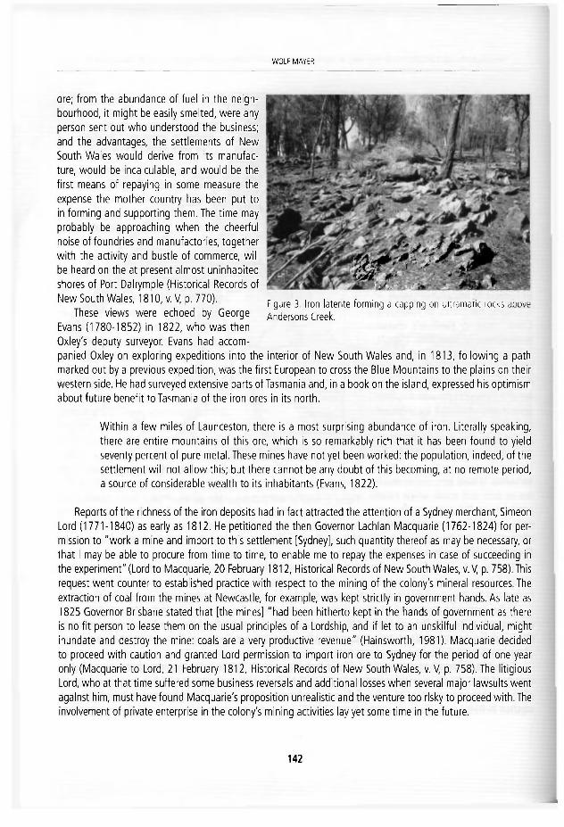
WOLF MAYER
ore; from the abundance of fuel ¡n the neigh-bourhood, it might be easily smelted, were any person sent out who understood the business; and the advantages, the settlements of New South Wales would derive from its manufac-ture, would be incalculable, and would be the first means of repaying in some measure the expense the mother country has been put to In forming and supporting them. The time may probably be approachlng when the cheerful nolse of foundries and manufactories, together with the activity and bustle of commerce, wlll be heard on the at present almost unlnhabited shores of Port Dalrymple (Historical Records of New South Wales, 1810, v.V, p. 770).
These views were echoed by George Evans (1780-1852) In 1822, who was then Oxley's deputy surveyor. Evans had accom-panied Oxley on exploring expeditions into the Interior of New South Wales and, in 1813, following a path marked out by a previous expedition, was the first European to cross the Blue Mountains to the plains on their western side. He had surveyed extensive parts of Tasmania and, in a book on the island, expressed his optimism about future benefit to Tasmania of the iron ores in its north.
Within a few miles of Launceston, there Is a most surprislng abundance of ¡ron. Literally speaklng, there are entire mountains of this ore, which is so remarkably rich that it has been found to yleld seventy percent of puré metal. These mines have not yet been worked: the population, indeed, of the settlement will not allow this; but there cannot be any doubt of this becoming, at no remote period, a source of considerable wealth to Its inhabitants (Evans, 1822).
Reports of the richness of the ¡ron deposits had In fact attracted the attention of a Sydney merchant, Simeón Lord (1771-1840) as early as 1812. He petitioned the then Governor Lachlan Macquarie (1762-1824) for per-mission to "work a mine and import to this settlement [Sydney], such quantity thereof as may be necessary, or Ihat I may be able to procure from time to time, to enable me to repay the expenses in case of succeeding in the experiment" (Lord to Macquarie, 20 February 1812, Historical Records of New South Wales, v.V, p. 758). This request went counter to establlshed practice with respect to the mining of the colony's mineral resources. The extraction of coal from the mines at Newcastle, for example, was kept strictly In government hands. As late as I825 Governor Brisbane stated that [the mines] "had been hitherto kept in the hands of government as there is no fit person to lease them on the usual principies of a Lordship, and if let to an unskllful individual, might Inúndate and destroy the mine: coals are a very productive revenue" (Hainsworth, 1981). Macquarie decided to proceed with caution and granted Lord permission to import iron ore to Sydney for the period of one year only (Macquarie to Lord, 21 February 1812, Historical Records of New South Wales, v. V, p. 758). The litigious Lord, who at that time suffered some business reversáis and additional losses when several major lawsults went agalnst him, must have found Macquarie's proposition unreallstic and the venture too rlsky to proceed with.The involvement of private enterprise in the colony's mining activlties lav yet some time In the future.
Figure 3. Iron latente forming a capping on' J & m a i c Í M T Í Andersons Creek.
142

THE DISCOVERY A N D EXPLOITATION OF IRON ORES IN COLONIAL AUSTRALIA WITH EMPHASIS ON THE DEPOSITS IN THE TAMAR VALLEY...
3. FIRST GEOLOGICAL SURVEYS OF TASMANIAN IRON ORF DEPOSITS
Despite the favourable reports from both Oxley and Evans, the outcrops of iron-bearing rocks in the Tamar district received little further attention until the 1860s. This interval of time coincided with major changes in the governance of colonial Australia. The Brltish colony of New South Wales, which orlginally covered about half of the entire continent, was divided Into a number of separate entities. Victoria became a colony In its own rlght In 1839, whi-le Van Dlemen's Land gained Its independence from the mother colony In 1855, and promptly changed its ñame to Tasmania. The transportaron of convicts had ceased by then. All new arrivals from Great Brltain were free settlers, many with professional quallfica-tions, ¡ncluding In science. Prívate enterprlse started to flourlsh and was less subject to government control. Tasmania, llke New South Wales and Victoria, appolnted government geologlsts or geological surveyors.
In 1859 the Tasmanlan Government appointed Charles Gould (1834-1893) as its first geological surveyor (Flg. 4). He was a gradú-ate of the Universlty of London who had worked with the Geologi-cal Survey of Great Britain. Gould carrled out extensive geological surveys of the Island colony, establlshed the first tentative framework of Tasmania's stratlgraphy and made an assessment of Its mineral resources (Banks, 1989; Banks and Yaxley, 2006).
In 1866 Gould examlned the geology of the Tamar Valley dis-trict and produced the first geological maps of the area. His detailed report ¡ncluded an account of the ¡ron deposits cropplng out above the banks of Andersons Creek, to the south of Yorktown, and also on rldges to the west of Beaconsfield (Gould 1866) (flgs. 2 and 5). Gould noted that the ¡ron deposits formed outcrops along two parallel Unes, separated by up to 10km from each other, and that they were aligned In a northwest-southeast directlon. This trend coincided with the topographic orlentatlon of the area's hllls and rldges and also with the general strike of the geological formatlons. On his printed map (Flg. 5) Gould showed only the larger of these deposits, whlle on his hand-coloured field map he also Indicated the lesser outcrops of ¡ronstone.
Based on the linear arrangement of the outcrops, Gould argued that an unspeclfied forcé had determined Unes of fracture along which the ores were emplaced by "a mineral forcé acting In defined dlrections". He tended to the view that the iron-rlch masses of large boulders and smaller debrls, often seen as a capplng on hllls and ridges (Flg. 3), constituted the surface expressions of "real mineral lodes" of ¡ron ore. He also noted that the ¡ron deposits were assoclated with two very different types of bedrock, and that thelr respective com-posltions differed depending on the rock type with which they occurred.
Gould examined the first of these ore types on Scotts Hill and Mt Vulcan located some 4 and 5 km, respec-tlvely, to the south of Yorktown (Fig. 2). The "lodes of ¡ron" he mapped there cropped out on hills composed of "serpentine". He identified the major ore mineral present at these locallties as "magnetlc oxide of ¡ron" or magnetlte. More recent studles identlfy the iron-bearing minerals as "concretlonary and plsolltic hematlte-qoethite material with subsidlary magnetite" (Gee and Legge, 1979).
143
Figure 4. Portralt of Charles Gould, Tasma-nia's first geological surveyor f rom 1859 to 1869.

WOLPMAY.ER
C í O L O r . i C A ! . M A P
I 1 7 S I T "
CHARttS &OVIO 40 t r € i l i g c u
•Jf I
fiXjt*
*írtir
Figure c Charles Gould's geological map (1866) o f t h e RIverTamar distrlct showing outcrops of ¡ron deposits"Refer to f igure 2 for a more precise location of these deposits.
1 4 4

THE DISCOVERY A N D EXPLOITATION OF IRON ORES IN COLONIAL AUSTRALIA WITH EMPHASIS ON THE DEPOSITS IN THE TAMAR VALLEY...
The second type of ¡ron ore Gould recognised was associated wi th "sandstone and grits" on the eastern side of Andersons Creek, and in the Cabbage Tree Hills and other ridges, to the west of Beaconsfield (Fig. 2), He was most likely referring to sandstones, siltstones and minor conglomerates that are now mapped as a number of separate formations of Ordovician to Late Cambrian age. The main difference he recognised in these deposits was that the principal iron-bearing mineral was "hematite" or "brown hematíte", a term then com-monly applied to what is now referred to as limonite.
While Gould clearty belleved that the iron ore of the Tamar Valley originated from a form of Igneous activ-ity, he made it clear at the beginning of his report that the iron ores associated with sedimentary rocks in this región are quite unllke those he had seen in other parts of the colony [Tasmania] "which consist merely of hematite formed by the deposition of ferruginous matter from rocks containlng a small percentage of iron". It appears from these remarks that he had some notion of the processes of weathering and decomposition of rocks leading to the formation of laterite, but did not consider that such an origin applied to the ¡ron deposits of the Tamar district.
4. LATERITE
The British surgeon Frands Buchanan coined the term laterite (from the latin lateritis = brick) as early as 1807 (Thurston, 1913) when he described ¡ron-rlch clays covering granite, which local inhabitants on the western coast of southern India cut into bricks. In his description of these deposits he implied an origin of the latente from the decomposition of the underlying granite.
The origin of iron laterite horizons as residual deposits does not appear to have been widely recognised and understood by geologlsts and naturalists working in the Australian colomes in the nineteenth century. It was not till early in the twentieth century that the processes of surface weathering of rocks, particularly through the work ofWalther (1915) and Woolnough (1918, 1927,1930) recelved general acceptance (see also Branagan, 2004).
William H.Twelvetrees (1848-1919), one of Gould successors asTasmanlan government geologlst, initially agreed wi th the latter's condusions with regard to the origin of the iron ores and stated that " the deposits are in more or less paraliel Unes north and south, which is, to say the least, suggestive of load origin", and further that "confirmatory of this idea is the fact that the granite outcrops in the serpentine follow the same direc-tion. As the ore deposits are at or near the contact of these rocks, we may suspect that the concentraron of the mineral is connected in some way with the intrusión of the granite". This 'evidence' led hirn " to imagine it highly probable that the ore deposit will, as a contact formation or lode descend to a much greater depth than the present level of Andersons Creek" (Twelvetrees, 1903),
However, following the work of the American geologists Cummlngs and Miller (1911), who described residual masses of iron ore in Cuba as "mantle or blanket deposits, forming a bed derived from the decomposi-tion of serpentine", Twelvetrees reallsed that such an interpretaron could also be applied to the deposits at Andersons Creek. He and his assistant geologist, Mclntosh Read, were now convinced that:
All the evidence points to the deposits being a residual mantle of ore resulting from the decay of the serpentine rock in situ. In this process the iron ores in the parent rock were In the main converted to limonite, some of them, however, surviving as hematite and magnetite (Twelvetrees and Read, 1919).
1 4 5
vVOLF MAYEK
5. M I N I N G OF IRON ORE
From as early as 1852, several ¡ron ore deposits, mainty composed of limonite, were mined in New South Wales and smelted to produce pig ¡ron. The first of these ironworks was established at Mlttagong which wasfol lowed by others, including operations at Lithgow (Harper 1923) and at Lal Lal, near Ballarat, in Victoria (Carroll 1977) (Fig.1). All of these early ventures operated intermittently, mostly during the second half of the nineteenth century, but generally with little proflt.
Following Gould's report of the richness of the iron ore deposits in Tasmania, particularly those which he had mapped at Andersons Creek, several newly-forrmed companies started mining operations in the area ín the 1870s. Analyses of ore samples, most likely taken selectively from outcrops rich in magnetlte, gave ¡ron contents as high as 70 %.
Except for trace amounts in one sample, none of these assays referred to the presence of chromlum in the ore. Following the start of mining operations and smelting of the ore it soon became apparent that ¡ts aver-age grade was much lower than at first indicated and, more damaging for the enterprlses, that it contalned significant amounts of chromium. The presence of this metal gave the pig iron a brittle quallty and, at that time, made it unsuitable for further processing, other than into cast ¡ron. An assay of the ore from Mt Vulcan on the west bank of Andersons Creek was given by Twelvetrees and Reid (1919).
Fe 53.06 % Cr303
Al 5.90 %
SI 5.40 % Cr303
Al 4.30 % S 0.13 % Loss on P Trace Ignition 7.30%
The history of the mining and smelting oí iron ore in the RiverTamar district is given in some detail by Just (1891). The latter was a director of the British andTasmanian Charcoal and Iron Company, which operated the largest of the mines at Mt Vulcan as well as a furnace at Beauty Point (Fig. 2). He and his company invested £100 000 in the venture and over a short number of years produced more than 10 000 tons of pig iron. How-ever, líke all other attempts at mining and smelting limonitic ¡ron ores in colonial Australia, this venture proved to be unviable.
6. ABUNDANCE OF IRON ORES
The governmerrt geologist of Western Australia, Harry P. Woodward (1858-1917), when journeying across the northern part of this colony In 1888-9, "became aware of the enormous riches of iron that the iand contained: it was easy to find but, at the time, too remote to be made use of". The vast outcrops of Banded Iron Formation he noted, and which are also found in southern parts of the continent, led him to conclude that: "This is essentialiy an iron country, for one cannot travel a mile in the parts where the older rocks appear at the surface, without encountering a lode... There is eriough to supply the whole world, should the present sources be worked out" (Woodward, 1894). These rich deposits of iron were first mined on a commerclal scale at Iron Knob in South Australia, in 1903 and, since the commencementof mining in West Australian in the 1950s they have indeed supplied much of the world.
1 4 6

THE DISCOVERY A N D EXPLOITATION OF IRON ORES IN COLONIAL AUSTRALIA WITH EMPHASIS ON THE DEPOSITS IN THE T A M A R VALLEY...
ACKNOWLEDGEMENTS
I thank John Dent for taking me on a tour of the oíd ¡ron mine sites in the Tamar Valley district. John Everard and Kylle Lau of the Department of Mineral Resources in Hobart helped with my search for early geoiogicai maps and supplied useful information.
REFERENCES
Banks, M.R. 1989. History of geoiogicai work in Tasmania. In: Burrett, C.F. and Mart in, E.L. (eds.), Geology and mineral resources of Tasmania. Geoiogicai Soclety of Australia, Special Publication, 15 ,1 -4 .
Banks, M.R. and Yaxley, M . l . 1972. Charles Gould (1834-1893) . Australian Dictionary of Biography. Melbourne University Press, Melbourne, 277-278
Branagan, D.F. 1972. Geology and Coal Min ing in the Hunter Valley. Newcastle Library, Newcastle. Newcastle History Monograph, 6 , 1 0 5 pp. .
Branagan, D.F. 2004. The desert sandstone of Austral ia: A late nineteenth century enigma of deposlt ion, fossils, and weather ing. Earth Sciences History, 2 3 , 2 0 8 - 2 5 6 .
Branagan, D.F. and Packham G.H. 2000; edi ted and produced by Stewart, R. Field geology of New South Waies. Sydney, New South Waies Department of Mineral Resources, 481 pp.
Carroll, B. 1977. Australia's Mines and Miners: An illustrated History of Australian Mining. The Macmi l lan Company of Australia, Melbourne, 14-15.
Cummlngs, L. and Miller, B.L. 1911. The characteristics and origin of the brown iron ores of Camaguey and Moa, Cuba. Transactions of the American Institute of Mining and Engineering, XLII, 136.
Evans, G.W. 1822, A geographicai, histórica!, and topographical description ofVan Diemen's Land, with important bints to emigrants, and useful information respecting the application for grants of land; together with a list of the most necessary anides forpersons to take out. John Souter, London, 58-59.
Gee, R.D, and Legge, P.J. 1979, Geoiogicai Survey Beaconsfield Sheet No. 30 (82 15N), fxp lana to ry Report. Tasmania Department of Mines, Hobart, 86-87.
Gould, C, 1866. Geoiogicai Surveyor's report of the country near Ifracombe, In the West Tamar District. Geoiogicai Survey of Tasmania 0 S _ 0 1 6 , 1-11, w i th maps and diagrams.
Hainsworth, D.R. 1981. The Sydney Traders: Simeón Lord and his Contemporaríes1788-182 f. Melbourne University Press, Melbourne, 190 pp,
Harper, L.F. 1923. Iron. New South Waies Geoiogicai Survey, BulietinA, 109 pp. Hill, D. 2009. 1 788. Wi l l iam Heinemann. Sydney, 24 pp. Jiist,T.C. 1891. Notes on the iron ore deposits ofthe River Tamar district, Tasmania and on the manufacture ofpig iron there
fro/n.Tasmanian Officlal Record, Appendix 1 5 0 1 , 4 5 7 - 4 7 0 . McCIenaghan, M.P. and Calver, C.R. 1994. Geoiogicai Atlas 1:250,000 digital series. Geology of Northeast Tasmania.
Tasmanian Geoiogicai Survey. Mayer, W. 2007. The quest for l imestone in colonial New South Waies, 1788-1825. in: Wyse Jackson, P.N. (ed.), Four
Centuries of Geoiogicai travel: The Search for Knowledge on Foot, Bicycle, Sledge and Camel. Geoiogicai Society, London, Special Publication, 2 8 7 , 3 2 5 - 3 4 2 .
Mayer, W. 2009. The geoiogicai work o f t h e Baudin expedit lon in Australia (1801-1803) : The mineralogists, the discoveries and the legacy. Earth Sciences History, 2 8 , 2 9 3 - 3 2 4 .
O'Brien, E. 1950. The Foundation of Australia (1788-1800). Angus and Robertson, Sydney, 118-119,
1 4 7

vVOLF MAYEK
Paterson, W. 1790. A nsrrafjVe of tourjourneys into the country ofthe Hottentots and Calfraria. J. Johnson, London, 171 pp. Thurston, E. 1913. Provincial geographies of India: The Madras Presidency with Mysore, Coorg and Associated States.
Cambridge University Press, 54-83 Twelvetrees,W.H. 1903. Report on the mineral resources of the districts of Beaconsfield and Salisbury. Tasmania Department
of Mines, OS 204, 24. Twelvetrees, W.H. and Reid,A.M. 1919. The iron deposits of Tasmania. Tasmania Department of Mines, Geological Survey,
Hobart. Mineral Resources, 6, 1-34. Walther, J. 1915. Laterit in West-Austral ien, Zeitschrift der Deutschen Geologischen Gesel/schaft, 67, 1 13-132. Woodward, H.P. 1894. Mining handbook ofthe colony of Western Australia: written especiaily for prospectors and strangers
to tñe colony wf io are interesíed in mining. R. Pether, Perth, 126 pp. Woolnough, W.G. 1918. The physiographic significance of latente ¡n Western Australia. Geological Magazine, 6 (5), 385-
393. Woolnough, W.G. 1927. The duricrust of Australia. Journal and Proceedings of the Royal Society of New South Wales, 58,
24-53. Woolnough, W.G. 1930. The influence of cl imate and topography on the fo rmat ion and distr ibut ion of producís of
weather ing. Geological Magazine, 67, 123-132. Young, G. Sir 1785. Plan for the estabfef iment of a colony in New South Wa/es. Pamphlet in four foolscap pages published
on April 2 1 , 1 7 8 5 .
1 4 8

J. £. Ortiz, 0. Puche, I. Rábano and L. F. M a z a d i e g o (eds.l f & t t t y o f f e s M K f i ki Mineralíesourtes, C u a o e m o s del Museo Geominero, 13. Instituto Geológico y M ine ro ce España, M a d r i d ISBN 9 7 8 - 8 4 - 7 8 4 0 - 8 5 6 - 6 © Insti tuto Geológico y M i n e r o de España 2 0 1 1
SURVEYING INDEPENDENT MEXICO: NEWACTORS AND OLD AMBITIONS
Luz F. Azuela1 and Lucero Morelos2
' i ns t i t u to de Geograf ía , Univers idad Nacional A u t ó n o m a de México, Ci rcui to Exterior s/n, C iudad Univers i tar ia , 0 4 5 1 0 , México, D. F. l a z u e l a ® gg .unam. rnx
f a c u l t a d de Filosofía y Letras. Un ivers idad Nacional A u t ó n o m a de México, C iudad Univers i tar ia , 0 4 5 1 0 , México, D. F. I u n a l u c e r o m @ y a h o o . c o n . m x
Abst rac t . The first edit ion of Humboldt 's "Pol i t ical Essay on the Kingdom of New Spain" (1811) set up an extraordinary dif fusion of Mexican weal th, only compared wi th the one that took place in the sixteenth century. Humboldt 's estimates on mining proflt stlrred up ancient ambit ions of Spanish commercial rivals, which could be accomplished after the Independence War (1810-1821) . During Guadalupe Vic tor ias government (1824-1828) hundreds of immi-grants arrived, encounter ing welcoming policies and markets. This paper wi l l analyze terr i torial explorat ion related to mining enterprising dur ing the first half of the 19Ui century. We wi l l focus on national and foreign actors involved on politics, education and financial ventures, In order to characterize them. And we wi l l refer to scientific producís, result ing f rom mining praspect-ing and surveying.
1. HUMBOLDT'S LEGACY
The first French edition of Humboldt's "Political Essay on the Kingdom of New Spain" (1811) set up an ex-traordinary diffusion of Mexican wealth, only compared with the one that took place in the sixteenth century. Slmultaneously, an English translation was published, and in a few months both editions ran out, as naturalists and entrepreneurs eagerly read Humboldt's deplction of Mexico's natural resources. Hls optimistic estimates on mining profit, on the other hand, stirred up ancient ambitions of Spanish commercial rivals, which could be accomplished after the Independence War (1810-1821).
A conquistador in a sense, Humboldt dominated the country and rendered it to modern science. By decod-ing its geological strata, climbing its peaks, registering Its flora and fauna, admiring its archeologlcal riches and ethnological dlverslty, he launched a new conquest of México.
Armed with an arsenal of scientific instruments, he visited Santa María Regla's basaltic prisms, envlsion-ing the "uniformity of geological processes". American volcanoes, on the other hand, reinforced his bellef on Earth's internal temperature, as the building forcé of Its crust. Here we may remember that he was able to examine the fallout of Jorullo's eruption (dated September 29th, 1759), which he dimbed and analyzed (1,301 meters over sea level). On the other hand, the geological profile between the Atlantic and Pacific Ocean led him to appreciate an overall visión of Mexican volcanoes, which he situated in parallel 19° north, dlrection
1 4 9
I

LUZ F. AZUELA A N D LUCERO MÚRELOS
east-west, comprising Tuxtla, Pico de Orizaba, Soconusco, Popocatépetl, Nevado de Toluca, Jorullo, Colima, Ceboruco and San Andrés Ucareo.
Humboldt's works were a starting point for further research and new vlews on the Americas. His "Pollti-cal Essay on the Kingdom of Nueva España" can be considered as a discovery for Its own inhabitants and a mandatory readlng for transcontinental travelers. In fact, Its intelectual influence on sdentists and travelers of the nineteenth century prompted a flow of systematized mineraloglcal and geological studles. Among his successors we can list Joseph Burkart, Eduard Mühlenpfordt, Emil Schleiden, Cari Pieschel, Henri de Saussure, Jules Lederq, J. Félix and H. Lenk, on the first half of the century.
Mining is the maln subject o f the second volume of his "Political Essay on the Kingdom of Nueva España", where Humboldt is concerned with the physical depiction of native mínerals, prospectlng methods, exploita-tion, beneflt and refining technlques in each of the most dynamlc mines during his residence in México (1803-1804). He also engages on work organlzation, technology and proflts of mines "renowned by its wealth, seniority and proxlmity to México City", specifically Catorce, Guanajuato, Real del Monte and Pachuca.Assign-ing the first place to the latter, which he considered "one of the richest in the whole Contlnent", the Prussian scholar lamented Its recent abandonment, due to Encino's flre destructlon, and urged authoritles and investors to restore exploitation (alluding to other wealthy mines, he assigned the third place to the Catorce Mineral in Durango) (Humboldt, 1822).
Bes ¡de his intrinsic valué, Humboldt's works appealed to sdentists, explorers and forelgn businessmen, who traveled to México and contributed to geological sciences and other disciplines. Particularly, during the years of 1824-1850, hundreds of European travelers connected to mining enterprlses tried to establish themselves in México. First, English Investors arrlved, and they were followed by Germán and North American mining entrepreneurs.
2. INDEPENDENCE AND IMMIGRATION
During Guadalupe Vlctoria's government (1824-1828), immigration policies were orchestrated, in order to promote foreign investments. Economic Incentives, such as mining concessions, land, and even tax exemption, were offered. In response, hundreds of Immigrants arrlved, encounterlng welcomlng policies and markets. Humboldt's description of Mexican rlchness combined with metropolitan thrivlng expansionlsm to meet local needs. Business leaders and politlcians from the young natlon promoted alliances and partnerships with fo-relgn entrepreneurs to enhance mining exploitation and commerce.
In October 8th, 1824, an offldal decree establlshed the conditlons for foreign investors to acquire mines In propriety. The same year, a powerfui company was formed in England, with Mexican and English investors, Induding Mexico's secretary of state Lucas Alamán (1792-1853) studied in the School of Mines and traveled to Europe in 1814, where he updated his scientlfic knowledge. As a politiclan, Alamán promoted public reform to sustain economic progress and scientlfic actlvlties. A member of a wealthy family and heir of long-standlng mining ventures, was also an intelectual and exceptional politiclan, who promoted economlcal progress by encouraging industrial growth,
The United Mexican Mining Association was founded In 1824, and three years later Its mines in Guana-juato, Guadalajara, Zacatecas, Chihuahua, Oaxaca and the State of México, produced enough wealth to be characterized as the most prosperous of the country (Aguiiar y Santillán, 1908; Ward, 1828). One year later, Alamán addressed the Congress and informed about the establishment of three Brltlsh and one Germán mln-
1 5 0

SURVEYING INDEPENDENT MEXICO: NEW ACTORS AND OLD AMBITIONS
ing business. Commenting on the high funds the companies invested, he declared they supported Mexican's independence, and defined mining as the base of the economy. In his own words:
Mines are the true wealth of this Nation and everything said in the contrary by speculative economists has been successfully refuted by experience (García, 1895}.
The United Mexican Mining Association was sustained until 1849, date of its dissolution as a consequence offinancial bankruptcy-from 1824 to 1847 operating costs imported $ 15 382 000; profit was $ 10 481 000 and losses ascended to $ 4 901 000.
In the meantime, a small British company excelled, not for the amount of its wealth, but for his Prussian director, Joseph Burkart. During his commitment in Tlalpujahua's mine, and later in Solanos (Ward, 1828), Burkart accomplished great productivity, and even made possibie the survival of the latter during the eco-nomical crisis of 1825-1826 (Von Mentz, 1982). Furthermore, Burkart wrote numerous scientificdocumentson Mexican geology and mines, and a valuable travelogue, entltled "Residence and Travels in México in the Years of 1825-1834. Observations on the Country, its Goods, the Life and Ways of its Inhabitants. Observations on the Branches of Mineralogy, Geognosy, Mining Science, Meteorology and Geography" -it was a two-volume book printed in Germany in 1836. We will discuss this book on the next section.
In addition to Burkart, many other Germans were following Humboldt's steps in México, mostly as staff of the American-German Mining Company (AGMC), whose foundation in 1824 led to significant immigration, In fact, the AGMC seemed to be such a lucrative business that "stocks were purchased by the Royal Prussian fam-ily" and managersWilhelm Stein and Friedrich von Gerolt were selected among the secretarles of the Prussian Mining Ministry (Von Mentz, 1982).
With a lesser impact in the economy — t h e Germán Company of Eberfeld had a valué of 127,552 sterling pounds— the Prussian business stood out for its gifted officials, who added to Burkart's contributions to geo-logical sciences (Ward, 1828). Among the most valuable scientists we find Friedrich von Gerolt, Charles von Berghes and Cari Christian Sartorius, who published numerous studies during their residence in México and maintained contact wi th local scientists after their departure—the three men arrived in 1824, and departed at different dates; except for Sartorius, who founded a farming business in Orizaba and only left for brief peri-ods during his lifetime. Others, like Karl Koppe, wrote books following Humboldt's model (Koppe, 1837). And some disliked México so much, that they criticízed Humboldt's "exceedingly positive" data. On the other hand, scientific works were valldated as contributions to Geology, subjectthat we will discuss on the next section.
3. ECONOMIC A N D SCIENTIFIC PROFIT
Mining exploltation ¡n Mexíco's contrasting and unknown topography demanded technical and scientific ex-pertise and it was provided by mining companies. Territorial prospecting was vital, since studies about México were scarce and travelers only counted on Humboldt's work, supplemented by dissimilar works such as George Lyon's "Travelogue around the Republic of México in 1826", John Taylor's "Selectíons from the works of the Barón de Humboldt, relating to the dlmate, inhabitants, productions and mines of México" (1824), and Henry G.Ward's "México in 1827", among others. As a result, geological and mineralogical studies were planned in order to evalúate economical potential of mines and lócate promising ventures.
The second most popular book among investors was probably Ward's work, whose goal was to provide information regarding British mining enterpríses, updating and completlng Humboldt's data. Responding to a requirement of the English government, Ward visited mining districts during three years, engaging in a meticu-lous research on every aspect of the business, induding Mexican social and political circumstances. As a result,
1 5 1

LUZ F. AZUELA A N D LUCERO MÚRELOS
Figure 1. Henry G. Ward, Map of routes to the principal min ing districts in the central states of México, in México in 1827.
he made available a great amount ot information on internal communicatlons, climate and work conditions, as well as investing viability. Among his contrlbutions, Ward's "México in 1827" provided a "Map of Routes to the Principal Mining Districts" on Central México (Fig. 1).
In fact, knowledge about Mexlcan natural and social pecullaritles was increased by foreign entrepreneurs and explorers, who faced social and natural pecullaritles that provided material for travelogues and sclentific papers. Complemented with regional maps, natural history registries and geographical depictlons, those works provided significant data about Mexico's nature and geological constltution.
Among financial Information and business accounts, the United Mexlcan Mining Association's Board Re-ports ¡ncluded geographical charts of mining districts, geological profiles and mine diagrams, prepared by Domingo Lazo de la Vega and Wllllam Glennie (Aguilar y Santlllán, 1908). Interaction between British miners and local scientlsts is shown in studies published by those authors in the "Bulletin of the Mexican Geographi-cal Society", among other local and British magazines—studies of this period were transcrlbed in mining magazines o f the late sixties and later on. Several "Reports" were wrltten by state minister Lucas Alamán, par-ticularly one explalning and translatlng mining terminology into Spanish. He also proposed the construction of a Geographical and Mining Atlas of México, "compillng all cartography completed by the mining companies" (Sánchez and Mendoza, 2000).
1 5 2
SURVEYING INDEPENDENT MEXICO: NEWACTORS A N D OLD AMEITIONS
Concerning the Germán companies, on the other hand, several staff officials published sclentlfic works that contrlbuted to Geology, especially those wrltten by Cari von Berghes and Frledrlch von Gerolt; after his reloca-tion in England (1824) he was hired by theAmerican-German Mining Company. During his residence in México, he worked in the British company of Real del Monte, and some years later he was appointed ambassador of the Prussian government. Specifically, their "Geognostic Chart of the State of México", was characterized as the first post-humboldtian research that contributed to the understanding of Mexico's configuraron (the late state of México included parts of current states of Guerrero, Hidalgo, Tlaxcala and Morelos) (Crespo, 1903; Aguilera, 1905; Ordoñez, 1946; De Cserna, 1990). And it also was the work that initiated geological cartography in this country.
More prolific than his partner, von Gerolt published elght artlcles on Mexico's geological features between the years 1825 and 1834, all of them edited by European and American scientifíc magazines (Berlin, París, Heidelberg, Stuttgart, Dusseldorf, Bonn, New York and México). Gerolt was concerned on metallurgy, geognos-tic profiles, volcanoes, and geological studíes of mineral districts, completed with astronomical, barometrical, thermometrícal and mineralogical registries (Aguilar y Santillán, 1908).
As for Burkart's travelogue abovementíoned, he explains ¡n the Introduction the purpose of completing Humboldt's research, following the program outlined ¡n his work. A true disciple of Humboldt, Burkart ex-pressed his goal to render a complete visión of Mexican nature by registering instrumental data, and complet-ing his text with cartography, profiles, charts, and illustrations. Geographically, Burkart's work covers his journey from San Blas to Tampico (between parallels 22° and 23°), and Includes some areas around México City. His bookgathers references about volcanoes, climate differences among locations.thermal waters, mineral districts and pre-Colombian constructions. Geological data are completed by theoretical dlscussions about mineralogi-cal characters and the relevance of fossil markers for correlatlng strata (Ramírez, 1875).
Following the steps of his mentor, Burkart surveyed the Jorulio Volcano and ascended Toluca's Peak; he vis-ited Santa Maria Regla's basalt piliars, and unsuccessfully searched for "Durango's meteor tic mass, mentíoned by Humboldt" (Ruvinovich, 1992). However, he carne across Sonnenschimdt's meteorite in Charcas, supporting cart wheels, outside the town's church.
Burkart's travelogue and the numerous scientifíc papers about Mexico's geological constitution circulated profusely in Europe, brínging more attention from scientlsts and exciting monetary ambitions from Prussia's financial and political rivals. In fact, his geological information appears in Saint Clair Duport's book "De la production des metaux precieux au Mexique, consideres en relation avec la géologie, la metallurgie et la poli-tique économique" (1843). By means of this book, Mexico's geological knowledge, attalned by Burkart, was transmitted to French-speaking countries (Combes, 1865).
As for his influence in Mexican sclence, Burkart maintained a continuous relationship with Mexican schol-ars after his departure in 1834. And his above mentíoned work was well known and copiously cited in books on Geography, Meteorology, Mineralogy and Geology, some of them published in the last quarter of the century. In fact, Burkart and von Gerolt appeared among founding associates of the Mexican Geographlcal and Statistical Society in 1833, in whose magazine appeared both their contributlons. Correspondence between Burkart and local geologists, -such as Miguel Velázquez de León, Andrés Manuel del Río, Antonio del Castillo and Santiago Ramírez, -continued on the years to come, and some of his later works included data obtained by his Mexican colleagues (Burkart, 1861).
Concentrating our last reflections on Joseph Burkart doesn't mean other travelers had less impact on geo-logical sciences or Mexican geology. We have chosen the most quoted author In the geological biblíography concerning Mexico's exploration in the first years following Its independence and a self-proclaimed follower of Humboldt's steps.
1 5 3

LUZ F. AZUELA A N D LUCERO MÚRELOS
Finally, we have triecí to show that mining prospecting and surveying resulted not only in econornic wealth, but in scientific producís as well. Some clrculated in México, but mainly, they were published In foreign maga-zines, and specimens and collections were sent to metropolitan museums. Neverthetess, geological sciences' heritage was increased, and Mexican scientists were encouraged to intensify their own research.
REFERENCES
Aguilar y Santilfári, R. 1908. Bibliografía geológica y minera de ia República Mexicana. Insti tuto Geológico de México. Imprenta y Fototipia de la Secretaria de Fomento, México, 30 pp.
Aguilera, J.G. 1905. Reseña del desarrollo de la geología en México. Boletín de la Sociedad Geológica Mexicana, 1, 54. Burkart, J. 1861. Memoria sobre explotación de minas de los Distritos de Pachaca y Real del Monte de México. Traducida
del alemán por D. Miguel Velázquez de León. Anales de la Minería Mexicana, México, 759 pp. Combes, CH.P.M. 1865. Exploration de gítes de minearais métall i féres et autres substances minérales employées dans les
constructions et l ' industrie. Archives de la Commission identifique du Mexique, Ministére de l ' lnstruct ion Publique, mprimerie Impériale, París, vol, 1, 78 pp.
Crespo, G. 1903. Industria minera. Estudio de su evolución por. ..para la grande obra de México. Su evolución social. Oficina Tipográfica de la Secretaría de Fomento, México, 80 pp.
De Cserna, Z. 1990. La evolución de la geología en México, fiew'sta del Instituto de Geología, 9 (1), 5. García, T. 1895. Los mineros mexicanos: Colección de artículos sobre tradiciones y narraciones mineras, descubrimientos de
las minas más notables, fundación de las poblaciones minerales más importantes y particularmente la crisis producida por la baja de la plata. Oficina Tipográfica de la Secretaría de Fomento, México, 274 pp.
Humboldt, A. 1822. Ensayo político sobre el Reino de ¡a Nueva España (Edición facsimiiar). Instituto Cultural Helénico-Miguel Ángel Porrúa, México, 4 vol., 1995.
toppe, C. 1837. Mexikanische Zustánde aus den Jahren 1830 bis 1832. Cotta, Stuttgart, 2 vols. Ordóñez, E. 1946. El Instituto de Geología. Datos Históricos. Universidad Nacional, México, 51 pp. Ramírez, S. 1875. Elogio fúnebre del Doctor H. José Burkart. Boletín de la Sociedad Mexicana de Geografía y Estadística,
2, 202. Rubinóvich, R. 1992. Las raíces de la meteorítica en México. Revista de la Sociedad Mexicana de Mineralogía, 5 (1), 18. Sánchez, M. T. and Mendoza, H. 2000. Humboldt y la minería de la Nueva España: ¿un análisis exhaustivo con fines
estratégicos?. In: Zea, L. (ed.), Humboldt y América Latina. Inst i tuto Panamericano de Geografía e Historia, Fondo de Cultura Económica, México, 61-78.
Van Mentz, B. 1982. México en el siglo XIX visto por ios alemanes. Universidad Nacional Autónoma de México, México, 481 pp.
Ward, H. 1828. México en 1827. Fondo de Cultura Económica, México, 367 pp.
154

J. E. O r t í , C- Puche, I. RSbt i rü a n d L F. V a a d i e g o (eds.) ¡íaory of Rseá'ch n M r e r c í A e s o v c e s . Cuadernas del M u s e o Geomine rc , 13. Instituto G e o l o g í a - y V l n e i o de España, Madr id . SBN 9 7 8 - & 4 - 7 8 4 0 - 8 5 G - 6 Q Instituto Geo'óglcc y "d inero de España 2 0 1 1
A BRIEF HISTORY OFTHE SAPPHIRE INDUSTRY IN QUEENSLAND
David Oldroyd
Schoo of History m i Ph i l osophy Univers i ty of New South Waies, Sydney, NSW ?0B2, Aust ra l ia [email protected] .au
Abstract . Alluvial sapphires were first found in Australia ¡n NSW by Samuel Stutchbury and W, B. Clarke in the 1850s, but the discoveries were not fol lowed up immedlately as the chief min-ing interest at that t ime was gold. In the 1870s in Queensland, a rallway was bullt westwards from the coastal town of Rockhampton, and just north of the Tropic of Capricorn, to serve the iniand mining centres (especially coal) and the inland pastoral district around the township of Longreach {where QANTAS started!), It reached the construction township of Anakie in 1879, 192 miles f rom Rockhampton. This was cióse to a sapphire field that had been díscovered by the Queensland surveyor Archibald John Richardson about 1873, and wi th rail access the area was soon opened up for pastoral runs and sapphire mining, the main settlements being called Rubyvale and Sapphire. Sapphires were also discovered in northern New South Waies near Glen Innes and Inverell but this paper concentrates on the Queensland field. Reports on the Anakie field were made by Robert Logan Jack (1882, 1892) and Benjamín Dunstan (1902). Samples of Queensland sapphires were displayed at an international exnlbit ion in London in 1899, where they attracted the attention of the Russian nobility and became fashionable. There was thus considerable activity in the Anakie field until W.W. I, but the industry declined in the 1920s and '30s due to the Great Depression and the collapse of the Russian market, Thlngs recovered after W.W II. There was a further revival in the 1960s and a boom in the 1970s, partly a result of the appllcation of the Thai heat treatment for colour enhancement. But the end of the Australian mining boom brought w i th it a decline in the sapphire industry. The use of big machinery helped for a time, but shortage of water for large-scale activity was a severe problem, In recent years, there has been a modest recovery due to tourism. After WWI, the Government purchased gems at a guaranteed price. The scheme failed, The mlners sold their poor stones to the Government and kept the good ones to sell themselves. But the Australians eventually found themselves at the mercyofTha i merchants who bought uncut gems for processing in Thailand, improved their appearance by heat treatment, and sold the good specimens as Thai or Burmese gems; and the poor-quality stones were sold as Australian! And today many of the stones sold to tourists In the Anakie area are in fact sourced in Thailand. The Queensland gems are found In a Iarge area of alluvial deposits to the east of the hills of the 'main divide'. In the Anakie Inlier the basement rocks are chlefly granite or metamorphics. There are also several basalt plugs and diatremes in the district, andevidence of a Iarge basalt lava-field, associated wi th the sapphires.The sapphire-bearing al luvium Is called 'wash'. It consists of day and sand wi th pebbles of jasper, weathered basalt, dlorite, granite, metamorphics, and cobbles of quartzite or silcrete, which are frequently associated wi th the sapphire-rich parts of the 'wash' . This deposit has not been dated by fossils, but the basalt it contains comes from rock of Late Oiigocene age. Some of it has been reworked as secondary 'wash', in which Pielstocene megafauna remains have been found. The sapphires are mostly in the primary 'wash', deposited in oíd river channeis. The ¡dea of the gems having orlginated as phenocrysts was expressed by Jack (1892). But the Dunstan report (1902) thought the gemstones were originally xenocrysts In the basalt, formed at depth and brought to the surface by the eruptlng basalt. The 'xenocrysts In the basalt' model remained the v lew fo r many years until the work of Lishmund and Noakes (1983), fo l lowing the discovery in 1982 of a new deeper lead of sapphlre-bearing rock in NSW, recognisable as having originally been a pyroclastic deposit. These rocks rarely crop out and they went un-noticed unt i fqu i te late In the story, There
1 5 5

DAVID OLDROYD
are also localities ¡n the Anakle area where sapphires have been found in pyroclastic rocks, and it's now thought likely that sapphires were brought to the surface by explosive volcanic processes before the basalt emplacement. The depth of sapphire format ion was est imated by Stephenson (1976) by examinat ion of the CO inclusions in the crystals, which suggested a pressure of > 1 0 kllobars, indicating format ion at tne depth of the upper mantle. Dates of associated zircons have been determined and it appears that the sapphires may have been formed at more than one period. Broadly speaking, in Australia the eruptives are younger the further south one travels in the continent, and in Victoria volcanic erupt ions may even have been seen by the Aborigines! An explanation (Wel lman and McDougal l , 1974) is that the cont inent is dr i f t ing northwards over a hotspot in the mantle. But there is no single hotspot trace and the different gem-fields do not all have the same geochemistries.Thus sapphires are of theoretical interest to Austral ian geologists, besides being of fascination to the Russian aristocracy, Thai merchants, gemmologists, social and economic historians, mining recluses, and even historians of science. The paper is i l lustrated by photographs of min ing machinery, both oíd and new, and the sights and sites around Rubyvale.
1. THE ENVIRONMENT OF THE QUEENSLAND SAPPHIRE FIELDS AND SUMMARY HISTORY
Alluvial sapphires were first found in New South Wales in the 1850s by Samuel Stutchbury (1798-1859), but they attracted little initial interest as the country was then excited by gold discoveries. Today, sapphires are mined commercially in northern New South Wales but this paper focuses on the sapphire industry in central Queensland, which has the larger field. The area is semi-arid (see Fig. 1), and has irregular rainfall (though occasionally heavy). The summers are exceedingly hot but the climate is pleasant in the winter months. There is low-level pastoral activity in the district as well as gem mining and tourism.
A railway was constructed inland from the coastal town of Rockhampton in the 1870s, approximately along the line of the Tropic of Capricorn, to serve an emerging coal industry and the pastoral lands around the small centre of Longreach to the west of the main divide. The line reached a construction centre at Anakie in 1879, about six years after zircons and sapphires had been found in the district at Retreat Creek (see Fig. 2) by a Scotsman, the explorer and Government Surveyor for the Rockhampton district, Archibald John Richard-son (1836-1900), who was doing the survey work for the railway construction. Initially Richardson thought that the red zircons were rubies. However, on being informed that they were not, but that there were sapphires in the sample examined, he purchased a mining lease in the area and tried to develop the site. But he had little success and went bankrupt in 1893, after having failed to sell stones successfully when he took some to London. Nevertheless, with easy rail access, prospec-tors soon migrated to the Anakie región to try to make a fortune out of the sapphires found in the extensive sheets of 'wash' (al-luvium or colluvium) in the district. Small settlements were established in the area, named Sapphire and Rubyvale. By the end of the century the area had a population of
¡ÉÍ^BEHÍMF^^Í I | Figure 1. The Drummond Range and the beginnings of the 'wash' deposits, to the west of the main sapphire fields. Photograph by author.
1 5 6
j

A BRIEF HIS'ORY O" THE SAPPHRE NDUSTR'*1 IN QJEENSLAND
* w l ; -y /F E A.K_, VAL E/ - y / ' /
•Jfw A-r ílCtfJBMt • »
^"TfeftTl i J^ * V ! !
, \ . R H F . L . S N S
£
W.rVicraf.eld ""
i . .^y'isAfSPé^ .4- ' I , / / / - JH-í-iSAirr
i n t e ' o-/ Hff
Giendorr.w'll -ST tf^w.-y*'
Anakie 5 í I ^ AMAKlE'CoViNS
ít'»"'™
SKETCH MAP Based on B . D U N S T A N
ANAKIE SAPPHIRE FIELDS 1 9 0 1
P L A T E I
Figure 2. Early sketch map of the area of the Anakie sapphire fields. From Baker and Vlllaroya (2001, Píate 1). Newsome's Camp is the site of taday's Rubyvale. Retreat Creek provlded the maln locality for sapphires, and also Tomahawk Creek.
about 200 mlners, some with their families. In 1902, the 'Anakie' locality was recognised as an offlclal min-ing field, subject to Queensland's mining laws.
Queensiand sapphires were exported to England, Germany, and America, and were displayed at the Greater Brltain Exhlbition In London in 1899, where theyattractedtheattentlon of the Russian noblllty, and thus became fashlonable, so that prices rose. Germán gem dealers acted as agents and many of the early prospectors were Germán. Some of the Queensiand sapphires were dark blue and not obvlously more beautiful than other gems, but perhaps their novelty on the market and thelr 'exotic' location made them attractive to Europeans, especially Russian aristocrats. In the early twentieth century, It was only the blue stones that had signlficant commercial valué but there was considerable mining activity in the Anakie field until World War I.
In the years up to World War I prices for sapphires were high, and the Anakie townships prospered, with one man being credited with extracting £8,000 worth. Another smaller field was found in 1918 at a locality called Willows (see Fig. 2). It produced chlefly green, yellow and partl-coioured stones (Broughton, 1979). With the end of World War I and the loss of the Rus-sian market, prices collapsed; but by 1922 there were stlll 2,000 residents on the fields, with shops, schools, etc. To try to alleviate the situation, the Queensiand Government established a compulsory centrallzed pur-chasing arrangement In 1923, with prices determined by a Government appointed grader. This scheme dldn't work well and the Government found Itself unable to sell the gems for the prices that they had pald, with some of the miners selllng their best stones prívate y.
Also, the graders were not always scrupulous (it was said). After a Royal Commisslon looked into the industry In 1928, the compulsory-purchase arrangement was terminated and most of the miners left the gem-fields. The Government attempted to provlde support through the Depresslon but there were few buyers for luxury Items ilke sapphires.
However, the sapphire market In the región recovered somewhat after World War II, with American service-men buying sapphires, and again in the 1960s, when tourists and gem collectors began to visit the reglón. In 1967, John Hule, a gem buyer from Thailand, vislted the Anakie fields and wasfol lowed by other Thai natlonals who contributed slgnificantly to the trade. They purchased the sapphires In substantial quantitíes and took them to Thailand for cutting and improvement in colour by heating (and sometimes by 'enhanclng' them with beryllium). These gems were not sold as Australlan stones, except for the ones of low quality or those that
1 5 7

DAVID OLDROYD
couldn't be enhanced by heat treatment. As a result, the Australian sapphires acquired a poor reputation in the Asian markets. The wage difference for sapphire cutting between Australia and Thailand was such that giving 'added valué' by cutting in the sapphires' country of origin was not worthwhile. Nevertheless, by 1969 the 'of-ficial' production yielded $1,000,000 and many sales were not included in the official statistics.
The first bulldozer arrived in 1965, and in 1968 150 square miles to the west of the townships (the richer part of the field) were set aside by the Queensland Government for small miners, prospectors and collectors, while the country to the east (where only large-scale mechanized working could be profitable) was made ava I-able to large operators, where machinery mining began in 1970. In the heavily mechanized areas, the 'wash' was spread on the ground in the sun to break it up before sieving by trommels (rotating 'drums') and then vibrating sieve screens. Final extraction was and is still done by hand picking. However, in the haste of boom conditions, many sapphires were not collected.
Tax concessions for mining offered by the Whitlam Federal Government (elected in 1972) caused an up-surge in sapphire exploration and mining more generally. The collapse of the Australian mining boom (especial-ly for nickel) brought with it a decline in the sapphire industry and by the 1980s, a period of recession, it was in decline due to an apparent exhaustion of supplies. Among others, the Thai merchants ceased to visit the fields.
A period of increased production followed as the company Great Northern Mining tried to monopolize the large-scale sapphire industry in Queensland. Great Northern Mining used heavy earth-moving equipment and sluiced the 'wash' with large quantities of water. Even so, the returns were marginal and the company is no longer active on the Anakie field. In recent years, however, there has been some recovery in the sapphire industry, chiefly due to tourlsm, especially at Rubyvale and Sapphire, where visitors do their own prospecting hoping to find something. The reality is that they don't find much as the creek beds have long been stripped of sapphires, and to find anything worthwhile mining has to be underground to get into the 'wash' material (see Fig. 3). Neverthless, today tourism accounts for as much of the income of the gem-field villages as the sale of stones, though the two are naturally interlocked.
When I visited the area in 2002, I was welcomed by Peter Brown, a successful local entrepreneur. He had ¡nitially been a small mlner at his 'Desperado Mine' near Rubyvale and opened a shop in the village in 1988 to sell his gems and those of other miners. In addition, he established a gem exhibition gallery, a bed and breakfast establishment, and a camping ground for backpackers with an Internet café, such as young people llke to use when travelling. An astute business-man, Brown allowed visitors and tourists to work in his mine for a fee per day or per week, and keep all the sapphires that they might find. i was shown how the system worked and this enabled me to get an excel-lent vlew of the interior of the sapphire mines and the visual appearance of the 'wash' (see Fig. 3).
Brown's gallery was tasteful and had excellent stones on display, including a large and beautiful or-ange sapphire priced (as I recall) at $10,000. He also employed people to do gem cutting and helped train others to learn the trade. A second establishment,
Figure 3. Wall of a mine in the 'wash', about twenty metres below the surface at Desperado Mine, Rubyvale. The technical description of the 'wash' is "polymictic gravel in a dayey labile sand matrix overlying a very fine-grained quartz sand" (Withnall et al., 1995, p. 163). Width of photographed area about two metres. Photograph by author.
1 5 8

A BRIEF HISTORY OFTHE SAPPHIRE INDUSTRY IN QUEENSLAND
c igure 4. The Bobby Dazzler Mine entrance at Rubyvale. Note the 'billy stones' by the wagón. Photograph by author.
Figure 5. Above-ground machinery at Desperado Mine, Rubyvale. (This is probably the largest of the small-scale workings.) Mater ial is brought to the surface in buckets, raised on the arch-shaped lift, and loaded into the rotat ing sieve (trommel), prior to washing. Photograph by author.
Figure 6. Quarrying by Great Northern Mining Company, east of Rubyvale, 2002. Photograph by author.
¡which also allowed people to go underground to view the workings, was vlsited (see Fig. 4) but this not com-pare favourably with Brown's. Many of the mlners seemed to be recluses or 'dropouts', content to toil away for •small reward under trylng conditions in the summer, though it is pleasantly cool underground.
The western (small-scale mining) and eastern (heavy mechanised mining) areas looked very dlfferent when I vlsited them in 2002 (see Figs. 5 and 6).
2. GEOLOGISTS' INVESTIGATIONS, REPORTSAND DESCRIPTIONS
The Queensland Government Geological Surveyor, a Scotsman named Robert Logan Jack (1845-1921), was sent to Inspect the field in 1891, and his 1892 report did much to encourage prospecting. He arranged for sapphlres to be exhibited a t the Mining Court o f the Queensland International Exhibltion at Brisbane in 1897 arid then the Queensland Court of the London Exhlbitlon of 1899, where the Anakle sapphires attracted favou-rable attentlon. Jack (1892) reported that the basement rock was gneiss, above which he observed a 'gravelly drlft' crowded with 'an extraordinary number of immense boulders of sandstone, quartzlte, and conglomerate-quartzlte' cemented in a sillceous matrix. Sapphlres were found among the smaller pebbles of the 'drlft' and especially around and beneath the large boulders. He supposed that the sapphlres were formed as phenocrysts In the basalts In the area and that the 'drift ' in which they are now found had accumulated in the channels of an ancient streambed.
While visiting the field, Jack observed about a ton and a half of wash-dirt being sieved, yieldlng 258 sap-phires from 3 to 179 carats each with a total weight of 3,289 carats (658 grams). He also reported seeing
1 5 9
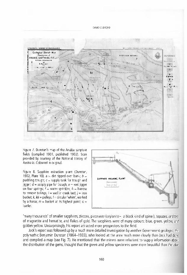
D A V I D O L D R O Y D
CF.OLOCICAL SURVEY OF QUEENSLAND
I Ceo log ica l S k e t c h M a p
I A N A K I E S A P P H I R E FIELDS* 1 CENTRAL OUEENSLAND
B Dunstan
í ' Km- lie- i .1 tf .••'] ¡jj G
r V y _ w _
1 ¡
_ r-1 1 J-i 1 Ir. ...
f - • j ! | .
Pjr!
í.
' I - J -J ( - , V
. , • . • y - ^
y y M
s ' / y c
PROPOSED RESERVE r
- i . . ' - • • • . ^ : :
W
. . t ^
| Í A . •. U :
11 • fl A. L . ^ • ' .•
i f V Í ^ . S l , J r — »
- -.
• . > _
• É J L H-rx.
l / F :
I 'll., « v - f f : I
Figure 7. Dunstan's map of the Anakie sapphire fields (compiled 1901, published 1902). Sean provided by courtesy of the National Library of Australia. Coloured in original.
Figure 8. Sapphire extraction plant (Dunstan, 1902, Píate 10). a = dirt t ipped over bank; b = puddl ing t rough; c = supply tank for t rough and j igger; d = supply pipe for t rough; e = wet j igger on four springs; f = water sprinkler; h = barrow to remove tail ings; i = wel l in creek bed; j = iron bucket; k, kk = pulleys; I = circular 'wh im ' , worked by a horse; m = bucket at its highest point; n = loader.
'many thousands' of smaller sapphires, zircons, pleonaste (ceylonite—a black kind of spinel), topazes, and bit; of magnetite and hematite, and flakes of gold. The sapphires were of many colours: blue, green, yellow, and goiden yellow. Unsurprisingly, his report attracted more prospectors to the field.
Jack's report was followed up by a much more detailed investigation by another Government geologist, the polymathic Benjamín Dunstan (1864-1933), who looked at the area much more closely than Jack had done! and compiled a map (see Fig. 7). He mentioned that the miners were reluctant to supply information about the distribution of the gems, thought that the green and yellow specimens were more beautiful than the blue
1 6 0
SAPPHIRE WASHING PLANT
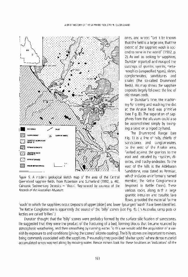
ABRIEF HISTORY OFTHE SAPPHIRE 'NDUSTRY 'N QUEENSLAND
ones, and wrote: "Let ¡t be known that the field ¡s a large one, that the extent of the sapphire wash is sec-ond to none in the worid" (1902, p. 2). As well as looklng for sapphires, Dunstan reported and mapped the outcrops of granite, syenite, meta-morphics (unspecifled types), slates, conglomerates, sandstones and shales (the so-called Drummond Beds). His map shows the sapphire deposits largely followed the line of oíd stream beds.
In Dunstan's time, the machin-ery for sleving and washing the dirt at the Anakie field was primitive (see Fig. 8). The separation of sap-phires from the alluvium could also be accompllshed simply by swing-ing a sieve on a tripod by hand.
The Drummond Range (see Fig. 1) Is a Une of hills, chlefly of sandstones and conglomerates, to the west of the Anakie area, faulted against the granites to the east and ¡ntruded by rhyolites, dl-orites, and trachy-andesites. To the east of the hills is the Aldebaran Sandstone, now dated as Permlan, which includes an informally named member, the Kettle Conglomérate (exposed in Kettle Creek). These various rocks, along with a large granitic intrusión and basaltic lava flows, provided the material for the
'wash' in which the sapphires occur. Deposits of upper (older) and lower (younger) 'wash' have been identified. The Kettle Conglomérate is apparently the source of the 'billy' stones (see Fig. 4). {In Australia, camp pots or kettles are called 'billies'.)
Dunstan thought that the 'billy' stones were probably formed by the surface silicification of sandstones. He suggested that they were the product of the fracturing of a bed, forming blocks that became rounded by atmospherlc weathering, and then smoothlng by runnlng water. To this we would add the acquisltion of a var-nish by exposure to aríd conditions (giving the stones' silcrete coating). The billy stones are important to miners, being commonly associated with the sapphires. Presumably they provided 'shelter spots' where dense material accumulated when washed along by movlng water. Henee miners look for these boulders as 'Indicators' of the
Figure 9. A modern geological sketch map of the area of the Central Queensland sapphire fields. From Robertson and Sutherland (1992, p. 46). Cainozoic Sedimentary Deposits = 'Wash' . Reproduced by courtesy of the Records of the Australian Museum.
1 6 1
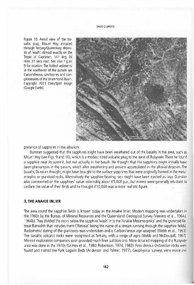
DAVID OLDROYD
Figure 10. Aerial v iew of the ba-saltlc plug, Mount Hoy, intruded through Tertiary/Quaternary depos-its of 'wash' . Almost exactly on the Tropic of Capricorn, 147 deg 26 mlns 37 secs east. See also Figure 9 for location. The fo lded sediments in the southwest of the picture are Carboniferous sandstones and con-glomerates of the Drummond Basin. Copyright 2011 Cnes/Spot Image (Google Earth).
presence of sapphires in the alluvium. Dunstan suggested that the sapphires might have been weathered out of the basalts In the area, such as
Mount Hoy (see Flgs. 9 and 10), which is a modest-sized vokanic plug to the west of Rubyvale. There he found a sapphire near its summit, but not actually in the basalt. He thought that the sapphires might initially have been phenocrysts in the basalts, which after weatherlng and erosión accumulated in the alluvlal deposits. The basalts, Dunstan thought, might have brought to the surface sapphires that were origlnally formed In the meta-morphic or granitoid rocks. Alternatively the sapphire bearing rock might have been ejected as lava. Dunstan also commented on the sapphires' valué: ostensibly about £5,000 p.a., but miners were generally reluctant to declare the valué of their flnds and he thought £10,000 was a more reallstic figure.
3.THE ANAKIE INLIER
The area round the sapphire fields Is known today as the Anakie Inlier. Modern mapping was undertaken in the 1960s by the Bureau of Mineral Resources and the Queensland Geological Survey (Veevers et al., 1964a, 1964b). They divided the rocks below the sapphire 'wash' Into the 'Anakie Metamorphlcs' and the granitoid Re-treat Batholith that intrudes them ('Retreat' being the ñame of a stream running through the sapphire fields). Radlometric dating of the granitoids was undertaken and a Carboniferous age assigned (Webb et al., 1963). The basaltic vokanic rocks were recognised as Tertiary, with a range of ages (Webb and McDougall, 1967). Mineral exploration companies soon provided much finer subdivisions. More detailed mapping of the Rubyvale area was done in the 1970s (Grimes et al., 1980; Robertson, 1974,1983). Fossiliferous Ordovician rocks were found and named the Fork Lagoon Beds (Anderson and Palmer, 1977). Geophyslcal surveys were made and
1 6 2

A RR'FF HIS~0KV Ü ' IHF SAPPHIRE N ! ) U S H V L'J O J H N S I A \ D
some drilling was done to try to define the areas of sapphire-bearing 'wash'. The rocks of the Anakie región have been minutely subdivided in recent publications (Withnall et al., 1995). Most of the sapphires occur in the Tertiary alluvials. A modern map is shown in Fig. 9.
4. SAPPHIRES, BASALTS A N D DATES
The ítems that specifícaily interest us are the Tertiary/Quaternary 'wash' and the Tertiary basalts, particularly the Mount Hoy Basalt, so named after a modest volcanic plug west of Rubyvale (see Fig. 10), which gives its ñame to a group of volcanic plugs of fine-grained basalt that intrude the 'Retreat Batholith' and from which the sapphires have been thought to be derived. But the basalts were not all formed at the same time as the various plugs and have a time-span of about 40 Ma. As can be seen from Fig. 10, the plugs sometimes form quite sígnificant topographic features, but some of the 'hills' are only about three metres high and mark diatremes. Brecciation is evident at the margins of some of the plugs. There are megacrysts in some of the basalts and also xenoliths. Pyroclastic rocks have been recorded relatively recently wi th air-fall and surge deposits, which íorm the basal layer of the sapphire-bearing strata (Robertson and Sutherland, 1992). Deep weathering ¡s evident in the mid-Tertiary in relie soils. Basalts are found occupying some of the ancient stream-beds.
The 'wash' (Late Miocene/Early Pliocene) is thought to have been formed during late Tertiary erosion when the mid-Tertiary surface was dissected and a late-Tertiary surface generated- The 'billy' stones in the 'wash' are thought to be the lagging coarser material that collected in the channets of a large flood plaín. Where preserved, the depositional surface has a veneer of ferricrete/sílcrete that Is also found on the stones. Rob-ertson (1983) dlvided the 'wash' into high-level (older) and lower-level (younger or secondary) 'wash', which distinction had previously been recognized by the miners. The sapphire concentraron ís greatest in the lower-level 'wash'. Some Recent sediments also contain sapphires, which are presumed to have been reworked. The gravelly components of the 'wash' and the 'billy stones' are generally associated with the most sapphires.
The theory that the sapphires were 'xenocrysts in the basalt1 and released by erosion and weathering, with subsequent dístribution by water in the 'wash' plaíns was the view held for many years after Dunstan, even though sapphires are not actually found In the basalts. But following the discovery In 1982 by a minerTom Nunan of a new deeper lead of sapphire-bearing rock in New South Wales, Llshmund and Oakes of the New South Wales Survey (1983) took a dífferent view. Though heavily weathered, the lead was recognisable as havíng originally been a pyroclastic deposit. Such rocks cropped out only rarely and their weathering was such that they had mostly gone un-noticed. There are analogous localities in the Rubyvale area where sapphires have been found in pyroclastic rocks, and it's now thought likely that sapphires were brought to the surface by exptosive volcanic processes (forming diatremes) that preceded the basalt emplacement. Radiometric dat-ing suggests that there were five periods of igneous activity, in the period from 56 to 14 Ma (Robertson and Sutherland, 2002, p. 53). These authors suggested that the sapphires are xenocrysts derived from near the crust/mantle boundary and transponed to the surface during the pyroclastic phases of eruptíon in late Pal-aeocene and early Ollgocene.The oldest plug is called 'Policeman's Knob' (see Fig. 9) near Rubyvale (56 Ma).
The pyroclastic origin of the sapphires has been supported by Jim Elliot, a member of the Queensland min-ing community (Elliot, 2003), who contends that the sapphires were produced from a large number of smaller vents, not the larger and more obvíous basaltlc plugs such as Mount Hoy. As in New South Wales, there are localised areas of volcanic ash found under the basalt layers and Elliot found numbers of sapphires in the tuf-faceous material. He looked for the small vents, searched for sapphires around them with considerable success, and conduded that the sapphires had not in fact been moved very far from their polnts of origin. The idea
1 6 3

DAVID OLDROYD
that some of them were rourided because of water transport was wrong, he thought, for with a hardriess of 9 on the Moh scale they could not have become rounded by abrasión in stream water. The rounding, suggested Elliot, must have occurred while the material was still molten and rising to the surface from the depths. He noted that the sapphires have small pinhole 'craters' on their surface, produced, he suggested, by the escape of small quantities of rutile just below the surfaces of the sapphires when the pressure was reduced by their emergence to the Earth's surface, the melting point of rutile being lower than that of sapphire (1,840°C rather than 2,030°C). There would be no minute pitting on the gems if the rounding were due to abrasión received on the Earth's surface.
It may be noted that rutile ¡ndusions can give sapphires a milky appearance. They can be driven off by heat, which is why heating enhances the gems' appearance. (However, it is the co-presence of titanium and ¡ron impurities in a sapphire that gives the gems their favoured vivid blue.) Elliot presented all this as his personal discovery (which it would have been so far as searching for and locating sapphires near ash deposits were concerned) but the idea of pyroclastic deposits as being sources of gem minerals was in the scientific literature prevlously (e.g., Hollis et al., 1983; Robertson and Sutherland, 1992). Hollis et al. suggested that maar erup-tions had occurred in the area, with diatreme outgassing bringing material to the surface, followed by the intrusión of basaltic magma, Regardless of which process for lifting sapphires to the surface is correct (and the two are not mutually exclusive) the cause of the formation of the sapphires at depth (at the upper mantle or the lower crust) awaits full explanation.
There are also zircons of different colours and ages associated with the sapphires, which have provided material for dating the igneous rocks by ¡on-probe U/Pb analysis and fission-track dating. Dates of 66, 58, and 20 Ma have been found (Robertson and Sutherland, 1992, p. 53), suggestíng that there has been more than one period during which sapphires were formed. These authors also identified air-fall and surge pyroclastic deposits in the Rubyvale field, and, based on K/Ar dating, they gave five periods of igneous activity for the Tertíary basalts: Paleocene, Early Oligocene, Late Oligocene, Early Miocene, and Late Miocene. They supported the idea that the sapphires were brought to the surface in Paleocene and Oligocene pyroclastics rather than being lifted by effusive basaltic eruptions.
5. HOT-SPOT THEORY?
The dating of ancient volcanic eruptions in Australia is of great interest, as, broadly speaking, the eruptive products are younger the further south one travels in the continent, and in Victoria volcanic eruptions may even have been seen by the Aborigines, according to their oral history. The case is important as the voicanoes are found within a continent, rather than an ocean such as the classic Hawaii case. An explanation by Peter Wellman and the well-known Australian geochronologist lan McDougall (1974a, 1974b) has been that the continent is 'drifting' northwards due to rifting between Antárctica and Australia, which caused the continent to move over two adjacent hot-spots in the mantle at about 66 mm a year, leavíng two traces of central voi-canoes down the eastern side of the Australian continent. This model is ¡n agreement with presently popular theories of mantle plumes and Tuzo Wilson's ideas about drifting over a hot-spot under Hawaii (to which work McDougall made his own contribution). There have, however, been other suggestions, such as changes ¡n stress fields with voicanoes opening vents to their sides if they grow 'too high' (as in the theory of Don Anderson [1999j), or the passage of Australia's píate over oíd sea-floor spreading zones. There is certainly not a single hot-spot trace in eastern Australia and the different gem-flelds don't all have the same geochemistry, which is perhaps unexpected. Be that as it may, sapphires have at Ieast a second-order connection with some o f the
1 6 4

A B-¡LTF HSTORY OF THE SAPPHIRE INCÜSTRV IN QLEENSLAND
most interesting ideas ¡n modern geological theory.
6. FINAL NOTE
There are recent (2010) reports that small-scale mining operations, such as those associated with the sapphlre and opal industries are currently facing severe economic difficuIties due to new environment taxes imposed by the Queensland and New South Wales Governments. With the current high valué of the dollar, which impedes exports, and rising interest rates, which impede local tourism, the future of sapphlre and opal mining is insecure (http://www.egoli.com.au/news-and-view5/government-review-to-streamline-small-mlning-sector/).
REFERENCES
Anderson, D.L. 1999. A theory of the Earth: Hut ton and Humpty Dumpty and Holmes. In: Craig, G.Y. and Huí!, J.H. (eds). James Hutton-Present and Future. The Geological Society, London, 13-35.
Anderson, J.C. and Palmieri, V 1977.The Fork tagoon Beds, an Ordovidan u n i t o f the Anakie Inlier. Queensland Government Mining Journal, 78, 260-263.
Anderson, 0. 1971. A century of sapphire mining. Queensland Government Mining Journal 72, 41 -51 . Baker, L.P. and Baker, T, 2001 Central Queensland Sapphire Fields: Historical Diary Combining all Facéis of the Gemíields'
Recorded History. Sapphire, The Authors, 114 pp, Broughton, P.L. 1979. Economic geology of the Anakie sapphire mining district, Queensland. Journal of Getnmology, 16,
318-337. Dunstan, B. 1902. The sapphire fields of Anakie. Queensland Geological Survey Pubhcation, 172, 26 pp. and plates. Elliot, J. 2003, The format ion of Queensland sapphire resources: an alternative theory. ht tp: / /www.austral iansapphire.com/
sapphire_format ion_theory.htm. Grimes, K.G., Robertson, A.D. and Anderson, J.C. 1980. Rubyvale 1:100,000 Geological Series, Sheet 8451, Preíim'mary
edition. Geological Survey of Queensland. Hollis, J.D., Sutherland, F.L and Pogson, R.E. 1983. High pressure minerals and the origin of the Tertiary breccia pipe,
Ballogie gem mine, near Proston. Records of the Australian Museum, 35, 181-194. Jack, F. 2008. Putting Queensland on the Map: The Life of Robert Logan íack: Geologist and Explorer. University of New
South Wales Press, Sydney, 275 pp. Jack, R.L. 1892. Sapphire, gold, and silver mines near Withersfield, Queensland Geological Survey Publication, 81, 4 pp.
and map. Krosch, N.J. 1985. Future directions for mining on the Central Queensland sapphire fields. Geological Survey of Queensland
Record, 1985/40, 17 pp. Krosch, N.J. and Cooper, W. 1990. Queensland mineral commodi ty report: sapphires. Queensland Government Mining
Journal, 91, 299-306. Lishmond, S.R. and Oakes, G.M. 1983. Diamonds, sapphires and Cretaceous/Tertiary diatremes in New South Wales.
Quarterly Notes: Geological Survey of New South Wales, 5 3 , 2 3 - 2 7 . Robertson, A.D. 1974. Preliminary geological report on the Anakie Min ing Field. Queensland Geological Survey Report,
1 9 7 4 / 1 8 , 1 5 pp. and map. Robertson, A.D. 1983. Notes on the geology of the Central Queensland sapphire fields. Geological Survey of Queensland
1 6 5

DAVID OLDROYD
Record, 1983/51, 28 pp. Robertson, A. D. C., and Sutherland, F. L. 1992. Possible origins and ages for sapphire and d iamond from the Central
Queensland gem flelds. Records of the Australian Museuw, Supplement, 15, 45-54 . Veevers, J.J., Randal, M.A. , Molían, R.G. and Patten, R.J. 1964, The geology ofthe Ciermont 1:250,000 Sheet area,
Queensland. Bureau ot Mineral Resources, Geology and Geophysics Australia, Report 66, 95 pp. and piates Veevers, J.J., Molían, R.G., Olgers, F. and Kirkegard, A.G. 1964. The geology of the Emerald 1:250,000 Sheet area,
Queensland. Bureau of Mineral Resources, Geology and Geophysics Australia, Report 68, 71 pp. and plates Webb,A.W., Cooper, J.A. and Richards, J.R. 1963. K-Ar ages on some Central Queensland granites. Journal ofthe Geological
Society of Australia, 1 0 , 3 1 7 - 3 2 4 . Webb,A .W. and McDougal l , 1.1967. A comparisor) of mineral and whole-rock potassium-argon ages of Tertiary volcanics
f rom central Queensland, Austral ia. Earlh and Planetary Science Letters, 3 , 4 1 - 4 7 . Wel lman, P. and McDougal l , 1.1974a. Potasslum-argon ages on the Cainozoic volcanic rocks of New South Wales. Journal
of the Geological Society of Australia, 21, 247-272. Wel lman, P. and McDougal l , I. 1974b. Cainozoic igneous activity in eastern Australia, fecfonop/iys/cs, 2 3 , 4 9 - 6 5 . Withnal l , I.W., Blake, P.R., Crouch, S.B.S., Tenison Woods, K „ Grimes, K.G., Hayward, M. A., Lam, J.S., Garrad, P. and Rees,
I.D. 1995. Geology of the southern part of t h e A n a k i e Inlier, Central Queensland. Queensland Geology Series, 7 , 2 4 5 pp. and maps.
1 6 6

, E. Ort i / , O- Puche, i. Rábano a r d L. r. Mazad iogo (eds.) Hs twy of ñesemh « Minera! «escures t u a d e n o s de l V j s e o Geoin inero, 13. I n s t M o Geo lóg ico y M ine ro de España, Mad r i d . ISBN 9 / 8 - 8 4 - / 8 4 0 - 8 S6-6 © Inst i tu to Geo óg ico y M i n e r o de t s p a ñ a 2011
EXPLORATION IN THE IBERIAN PYRITIC BELT: A REVIEW
Femando Vázquez Guzmán
E.T.S.I. M inas-Un ivers idad Pol i técnica de Mad r i d . C/Rics Rosas 2 " , M a d r i d 2 8 0 0 3 , Srwiri. femando' , vazquez@üprr- .es
Abst rac t . The Iberian Pyrite Belt stretches some 250 km f rom Sevilie, in Spain to the South western coast of Portugal. Min ing activities have been tak lng place f rom around the year 2000 BC. Tartessians, Phoenicians, and Romans extrated copper, gold and silver f rom the gossans and supergene-enriched zones overlying the pyrites orebodies. It is again in the 19th century when interest on copper extraction revived, mainly f rom secondarlly enriched upper zones in the orebodies, and in the latter years of the century up to 60 mines were in operation. In the 20th century pyrites f rom the Iberian Pyritic Belt became an important source for making sulphuric acid but f rom the early 1950s onwards there was an ncreaslna compet l t ion f rom other sources. Research of areas considered "best po tent ia l " for massive sulphide explorat ion and the evolu-t ion of the concept of geological models related to the fo rmat ion of the orebodies gave as a result a change on research methodology. This change, greatly ¡mproved by the Introduction of gravimetric methods, enabled to detect orebodies, specially those located at a deeper level. A very active approach of min ing companies and official insti tut ions made it possible to discover new important orebodies, sucn as Neves-Corvo and Las Cruces, whereas others were located near existing mining sites such as Los Frailes, Migollas and Aguas Teñidas.
1. INTRODUCTION
Mineral exploration in the Iberian Pyritic Belt (IPB) dates back to the Román and pre-Roman times (Figs. 1 and 2). This was a very successful period leading to the discovery of aimost all the outcropping deposits. Practically all the mines operating until the start up of Neves-Corvo (1989} were previously worked by the Romans.
The Iberian Pyritic Belt geology (Fig. 3) can be assembled In three main llthologlcal sequences (Fig. 4): A detrital sandy/shale substrate (phyllites and quartzites) of late Famennian age; A Volcano-Sedimentary Com-plex (slates, quartzites, sandstones, limestones, etc) hosting massive sulphides with ages which range from the late Famennian to the late Visean; A flysch succession composed of shale and greywacke dated as late Visean (Culm).
The Hercynian orogeny produced a complex structural evolution with a major deformation phase, giving rise to east-west structures in Spain and southeast-northwest structures in Portugal, and development of folds with south-verging multi-order folds, axial planar deavages and thrusts. Its forced the detailed study of the stratlgraphy of the formations and structural control of Its, in order to determine the locatlon of volcanic centers and potential orebodies hidden.
Since the second half of the 19th century, a renewed interest for these mineralizations turned them ob-ject of exploration and exploitation. Large reserves of polymetallic massive sulphides and secondary enriched
1 6 7
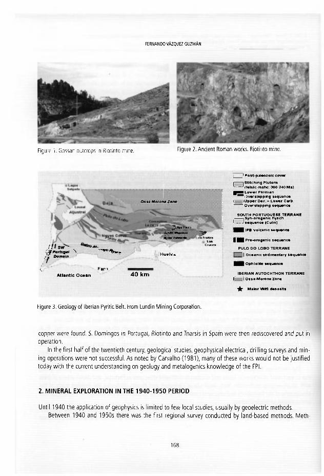
FERNANDO VÁZQUEZ GUZMÁN
Figure 1. Gossan outcrops in Riotinto mine. Figure 2. Ancient Román works. Riotinto mine.
O s s a Morena Zonc
^¡Portugal N y.
I . F ü ••> Atlantic Ocean
Jli- RJ O í\,r
Moolu* Ñi M* rfaivardB .
hluelvu
4 0 k m
L 1 4o>t-pal*ozolc cov«r i 1 Stitc hing Plutons 1 1 f»l«ic-maftc 300-340 Ma) JMLovi Permian
)v*rstepping sequeric* f lUpper D«v - Lower Carfo.
Overstcpptng sequenc» SOUTH PORTUOUESE TERRANE ¡yn-orogonic flys ch
' 's«qu«nc« (Cutm) IPB volcanic toquanca
H Pr»-orog«nlc s«qu*nca PULO DO LOBO TERRANE | Ocoanic sedimontary s*qu«nc«
Ophiolite Mquanc* IBERIAN AUTOCHTHON TERRANE
I I Ossa-Morena Zon« •je Malar VMS d«>osit>
Figure 3. Geology of Iberian Pyritic Belt. From Lundin Mining Corporation.
copper were found. S. Domingos in Portugal, Riotinto and Tharsis in Spain were trien rediscovered and put iri operation.
In the first half of the twentieth century, geoiogicai studies, geophysical electrical, drilling surveys and min-ing operations were not successful. As noted by Carvalho (1981), many of these works would not be justified today with the current understanding on geology and metalogenics knowledge of the FPL
2 MINERAL EXPLORATION IN THE 1940-1950 PERIOD
Until 1940 the application of geophysics is limited to few local studies, usually by geoelectric methods. Between 1940 and 1950s there was the first regional survey conducted by land-based methods. Meth-
168

EXPLORATION I N T H E I B E R I A N P Y R I T I C B E L T : A R r v i f W
r-~ - • } Sha les and «amis tan»
g g g F c t s k f l o w s and tuffs |VA1,
Purple sha les
*, Vcrocolt t rvd lufT and luf l i tcs
OT Mafk How* and tulT* I " \ F d t í c tu (Tries a n d cptclasl i lvs
F e M n ¿aspen
Lavas. brtxcias and tufó <vAl» ¡ Mam ve sutphide deposits
"•*•*; Mafíc iubvolcank rock» (ullt) TuíTHes and Mack shales
tufli» and lavas ivA1» ¡ ' Shales and quaruitc»
Simptifcij uratigraphk- «miuohv fot ibc t iudxd toan tmoáfted íiorn Sétt fl al I9M).
Ligure 4. Simplif ied stratigraphic sequence of the Iberian Pyritic Belt. Modi f ied f rom Sáez et b'. (1996).
Figure 6. Photomicrograph of slate showing the fo ld ing style.
ods like "Turam" and "Racom" offer no practical results, except the dlscovery of a small mass (Cerro do Carrasco) near Ajustrel, Portugal. Also, In Portu-gal, the method of self-potential was tested with-out positive results (Carvalho, 1981).
In the decade of the 50s, several aerial geo-physical methods are applied in Spain that report-ed numerous anomalles caused by carbonaceous shales or wet areas. The aeromagnetic investigaron clearly delimited the volcano-sedimentary rocks with máximum on basic rocks (Strauss et al., 1974).
Ore formation by hydrothermal replacement was advocated by most geologlsts, for there is obvi-ous replacement of the rhyollte or tuff by sulphldes, and replacement of one sulphlde by another in the ore.
3. MINERAL EXPLORATION IN THE 1960-1970 PERIOD
In 1960, almost colnciding with the new concept syngenetic on the pyritic deposits, a new stage be-gins with the application of geophyslcs methods. In Spain, the spontaneous polarizaron, reslstivity and electromagnetic, "Turam and" Slingram" methods, were regularly applied, supplemented by gravlme-tric method. At the same time, In Portugal, the gra-vimetric method is applied as a basic method of investigaron.
From the 60's until today the basic prospec-t a n is gravimetry method normally accompanied by magnetometrlcs and with the support of geo-logic cartography highly quallfied Fig. 5 and 6). When dealing with locallsed areas and to confirm gravlmetric anomalies which have been previously detected, electrlcal methods are usuaily applied (reslstivity, induced polarisation, electrical drilling), electromagnetic, selsmic and magneto-telurlc) (Mo-rales, 1999).
But the experience of the different geophysical methods indícate that more effectlve implementa-tion In the discovery of new bodies of sulphldes is the combination of resistivity and gravlmetric meth-
Fígure 5. Block diagram showing the tectoníc style of the Iberian Pyritic Belt (Febrel, 1967).
1 6 9

FERNANDO VÁZQUEZ G U Z M Á N
ods. When there ¡s a good spatial coincidence be-tween electrical conductors and gravity highs, the "metal anomaly" ¡s recognlzed with a borehole (Strauss et al., 1977).
Geochemlstry dld not give meanlngful contribu-tion to dlscovery so far, but the potential appllcabil-Ity of this method has not been fully tested and de-serves adequate development (e.g., rock geochem-istry, blogeochemlstry and hydrogeochemlstry).
In 1961, A.R. Klnkel (Klnkel, 1962) vlslted Rio Tinto and determined that the rocks in Huelva dls-
rigure 7. Pyrite Tolaed witn a pre-tectonic origin and a trict are rhyolltic rocks, malnly flows and pyrociastic concordance with rocks in which it is inserted (Aznalcollar roc|<s conformable with the overlylng shale, rather M i n e ) - than Intrusive porphyries as they were previously conslaered. What it is more important Is that a correct interpretaron of the origin of the rhyolltic rocks is critlcal to an understandlng of geology and genesis o f the masslve pyrite deposits. Previously, others have recognized that almost all the rhyolitic rocks and some diabase are volcanic flows.
Figure 8. Bouguer anomal ies o f t h e Reserve "Faja Pirí t ica" (Dirección General de Minas- I .G.M.E. , 1992) .
1 7 0
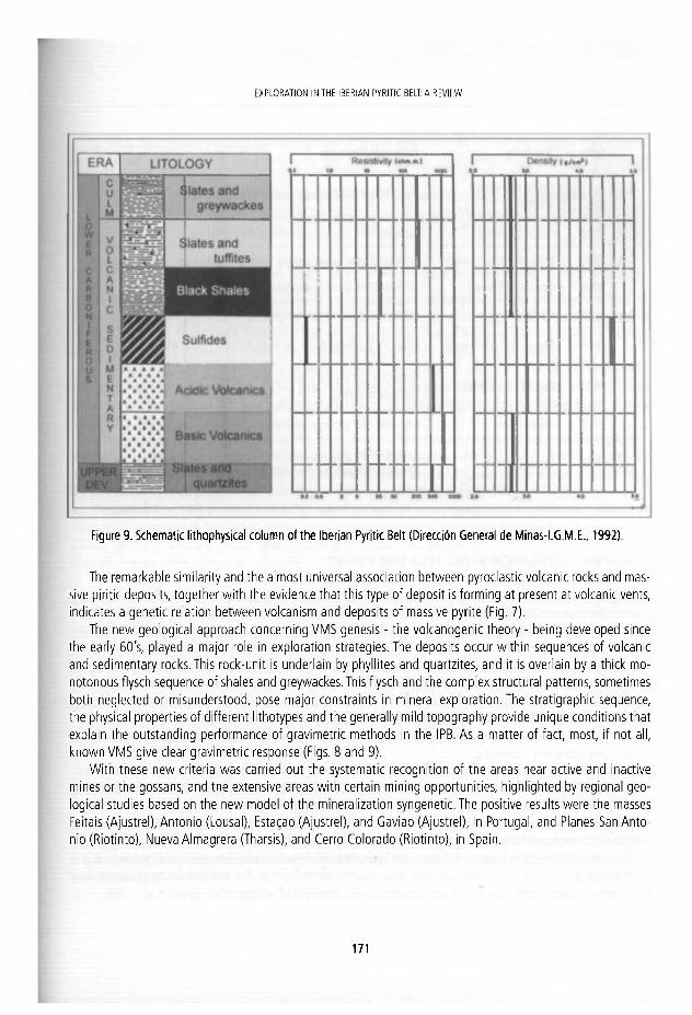
EXPLORATION IN THE I BE RIAN PYRITIC BELT: A R r v i f W
Figure 9. Schematic lithophysical column of the Iberian Pyritic Belt (Dirección General de Minas-I.G.M.E., 1992).
The remarkable similarity and the almost universal association between pyroclastic volcanic rocks and mas-sive piritic deposits, together with the evidence that this type of deposit is forming at present at volcanic vents, indicates a genetic relation between volcanism and deposits of massive pyrite (Fig. 7).
The new geological approach concerning VMS genesis - the volcanogenic theory - being developed since ihe early 60's, played a major role in exploration strategies. The deposits occur within sequences of volcanic and sedimentary rocks. This rock-unit is underlain by phyllites and quartzites, and it is overlain by a thick mo-notonous flysch sequence of shales and greywackes. This flysch and the complex structural patterns, sometimes both neglected or misunderstood, pose major constraints in mineral exploration. The stratigraphic sequence, the physical properties of different lithotypes and the generally mild topography provide unique conditions that explain the outstanding performance of gravimetric methods in the IPB. As a matter of fact, most, if not all, known VMS give clear gravimetric response (Figs. 8 and 9).
With these new criteria was carried out the systematic recognition of the areas near active and inactive mines or the gossans, and the extensive areas with certain mining opportunities, highlighted by regional geo-logical studies based on the new model of the mlneralization syngenetic. The positive results were the masses Feitais (Ajustrel), Antonio (Lousal), Estagao (Ajustrel), and Gaviao (Ajustrel), in Portugal, and Planes-San Anto-nio (Riotinto), Nueva Almagrera (Tharsis), and Cerro Colorado (Riotinto), in Spain.
1 7 1

TEF!NAfJDO VÁZQUEZ GLIZWÁN
Date Deposits (Principal Methods
1953/55 Cerro do Carrasco (Aljustrei)
ELECTROMAGNETIC, mechanical dri l l ing and mining works
1963 Feitais (Aljustrei GRAVIMETRY, mechanical dril l ing, mining works
1966 MassaAntonio (Lousal) • GEOLOGY, mechanical dril l ing, min ing works
1968 Estagao (Aljustrei)
1970 Gaviao
1974 | Massa José e Fernando
1976 | Salgad nho (Cereal)
1977 Neves-Corvo
; " i 1992 Lagoa Salgada
GRAVIMETRY, geology, mechanical dr i l l ing
GEOLOGY, gravimetry, mechanical dri l l ing
RES TIVITY, GRAVIMETRY, geology, dril l ing, mining works
GEOLOGY (alt. hldrot.), geochemist, gravimetry, mechanical dri l l ing
GRAVIMETRY, geology, mechanical dr i l l ing
GRAVIMETRY, geology, aeromagnetometry, magnetometry. e lectrkal methods, seismic, mechanical dri l l ing
Tabie 1. List of orebodies discovered and explorat ion methods in Portugal (cf. Carvalho, 1981, and completed)
4. MINERAL EXPLORATION IN THE 1970 -1980 PERIOD
Confirmation o f the existence of hydrothermal alteration related to the formation of orebodies supplemented the volcamc-sedimentary model, The orebodies are associated with the flow of relatively high temperature fluids, responsible for those same changes. A classical geological mapping now joined the hydrothermal alte-rations mapping.
During this period, Neves-Corvo was the major discovery in 1977, by drilling of an anomaly picked up on a regional gravity survey It remains the targest "bl ind" orebody discovered in the Iberian Pyrite Belt. It made possible to define a new orebody model in the Pyrite Belt, in which Cu and Sn metal grades are very high. Other discoveries in Portugal were the masses José e Fernando (Lousal), and Salgadinho (Cereal).
In Spain discoveries were the following: Sotiel (Calañas), Aznalcoílar, Cantareras (Tharsis), Alfredo (Ri-otinto), and Romanera (Paymogo).
As already stated, geophysical studies are of paramount importance in exploration in the IPB since long. In recent years, new instruments, and widespread use of powerful computer, and adequate software (including geographical information system) have revolutionized the production of geophysical maps, and the definition of anomalies. It is increasingly easy to visualíze the information, and test various valúes for critica! parameters, until best fits are found between geophysical and geological data. (Barriga, 1996)
Thus, the identlfication of areas is easier trough interpretation of multi-source data geological, geophysical and geochemical data in G.I.S., in the Herrerías mine area, near Puebla de Guzmán.The multidataset approach provides much more focused targets than merely usín geochemical (o geophysical) interpretation (Braux et al., 1996).
1 7 2
EXPLORATION IN THE I BE RIAN PYRITIC BELT: A R r v i f W
In 1984, the impulses electromagnetic methods of time dornain (and EMB7 TEM) are used for the first time, combined with PEM-Crone for the definltion of deep electromagnetic conductors, on the Aguas Teñidas Project (Rodríguez et al., 1996).
Later, in 1995, also Masa Valverde was tested with the thermography method. (Castrovlejo et al., 1996). New deposits were defined in Concepción and Romanera, both with gravimetrlc and mechanlcal drilling.
5. MINERAL EXPLORATION IN THE 1980 -2000 PERIOD
It Is in the 80's when accumulated knowledge on geology and metalogenics in the IPB, together with an ¡mprovement In the geophysics methods applled and its computerised treatment, led to the establishment of research objectives. These reach frequently 500 metres level and located In higher risk areas, where tectonic complexlty and the existence of thrust have altered the sequence of horizons and structures.
In 1985, a massive sulphldes body {with pyrite, chalcopyrite, sphalerlte and galena llke major components) was interseted: Aguas Teñidas mine. One year later, after a systematic exploration inlciated In 1982, Masa Valverde was discovered. It was a new thlck polymetallic massive sulphide ore body, located at depth of more than 400 m belowthe Culm.
After two decades, slnce Neves-Corvo discovery, several ¡nferencescan be pointed out from results.Among them it turns out clear that, in spite of the relatlvely high investment In the 80's, no discoverles occurred in Portugal. On the other hand, this was the exploration golden period in Spain, where 7 new deposits were discovered wi th a total of more than 250 Mt of polymetallic sulfides (Carvalho, 1999).
The discovery of Lagoa Salgada, In 1992, was from the use of several geology-dlrected and geologically interpreted, geophyslcal exploration methods, prínclpally gravimetry, aeromagnetometry, and magnetometry. Others methods used and tested were resistlvity, electrical soundings (VES), seismlc, and magnetotellurlc (Castelo Branco, 1996; Ollveira et al., 1998).
In 1993-1994, a gravity survey revealed a gravlty high of considerable size on the eastern of the Sevilla area (Las Cruces) which was tested with several Schlumberger soundings. From experience In Portugal was interpreted as the bed rock dipped unlformly to the south with no evídence of sufflcient palaeorellef to cause the gravity anomaly. It was also noted that the Schlumberger soundings showed unusually low resistivitles compared to bedrock from soundings in the Sado Basin (Doyle, 1996).
In 1995, North Lombador deposlt was discovered through geology and gravimetry survey, in an area near Neves-Corvo on which SOMINCOR conducted an aeromagnetlc and radiometric survey. In addltion, the large Masa San Guillermo was discovered by mining operations assoclated with the Tharsis mine.
The area with higher copper content of Migollas was mined since 1994, after reaching the orebody through the exlstent infrastructure In Sotlel, while open pit mining in Los Frailes started in 1997.
6. MINERAL EXPLORATION IN THE 2 0 0 0 - 2 0 1 0 PERIOD
In this decade no new pyrite bodies research was conducted. The works have been dlrected to the oíd deposits such as San Telmo-Cruzadillo (Cu), Lomera (Au), Rio Tinto (Au) and La Zarza (Au), owing to the increase of the copper and gold pnce. Also the mlnerallzation of cobalt In Tharsis mine is Investlgated (Strauss and Beck, 1990) and personal communlcations.
1 7 3
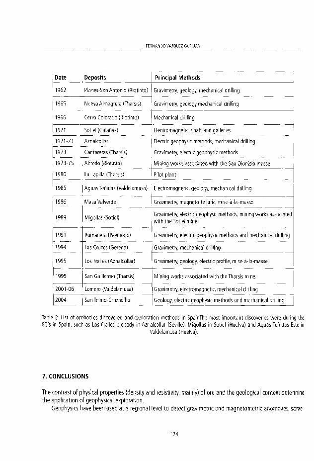
FERNANDO VÁZQUEZ G U Z M Á N
Date Deposits Principal M e t h o d s
1962 Planes-San Antonio (Riotinto) Gravimetry, geology, mechanical dri l l ing
1955 Mueva Almagrera (Tharsis) Gravimetry, geology mechanical dri l l ing
1966 Cerro Colorado (Riotinto) Mechanical dril l ing
1971 Sotiel (Calañas) Electromagnetic, shaft and galleries
1971-73 Aznalcollar Electric geophysic methods, mechanical dril l ing
1973 Cantareras (Tharsis) Gravimetry, electric geophysic methods
1973-75 Alfredo (Riotinto) Mining works associated wi th the San Dionisio masse
1980 La Lapilla (Tharsis) Pilot plant
1985 Aguas Teñidas (Valdelamusa) Electromagnetic, geology, mechanical dril l ing
1986 Masa Valverde Gravimetry, magneto-telluric, mise-á-la-masse
1989 Migollas (Sotiel) Gravimetry, electric geophysic methods, mining works associated wi th the Sotiel mine
1991 Romanera (Paymogo) Gravimetry, electric geophysic methods and mechanical drilling
1994 Las Cruces (Gerena) Gravimetry, mechanical dri l l ing
1995 Los Frailes (Aznalcollar) Gravimetry, geology, electric profile, mlse-á-la-masse
1995 San Guillermo (Tharsis) Mining works associated w i th the Tharsis mine.
2001-06 Lomero (Valdelamusa) Gravimetry, electromagnetic, mechanical dril l ing
2004 SanTelmo-Cruzadil lo Geology, electric geophysic methods and mechanical dri l l ing
Table 2. List of orebodies discovered and exploration methods in SpainThe most important discoveries were during the 80's in Spain, such as Los Frailes orebody in Aznalcollar (Seville), Migollas in Sotiel (Huelva) and Aguas Teñidas Este in
Valdelamusa (Huelva).
7. CONCLUSIONS
The contrast of physical properties (density and resistlvity, mainly) of ore and the geological context determine the application of geophysical exploration.
Geophysics have been used at a regional level to detect gravimetric and magnetometric anomalies, some-
1 7 4

EXPLORATION IN THE SERIAN PYRITIC BELI: A REVIEW
times applied jointly wi th radíometrics. However, aeroport exploration campaigns have been often with the combined use of electromagnetic techniques (AEM), magnetic and radiometric (AM- R}, as used in the flight conducted in 1995-1996 by the Directorate General of Mines, of Spanish Ministry of Industry and Energy, on the State Reserve "Faja de Minerales Plriticos" (García Lobón, 1996}
According to Carvalho (1999), three main groups of potential areas should be considered; 1) Volcanic-Sedimentary outcrops or sub-outcrops; 2) Tertiary Covered; 3} Deep Flysch. Each of these areas has specific features that pose particular problems to be solved for target selectlon, mainly concerning structural control, tectono-stratigraphy, and physical volcanology. There still remalns a considerable potential for targets between 200 and 500 m in all the above mentioned areas, but the highest potential is beyond this lower limit in all the three group of terrains, particularly in the Deep Flysch domain. Surely, very few promising targets at depths shallower than 200m still remain in Volcanic-Sedimetary areas; better possibliities may be offered by some Tertiary Covered sectors (Sado and Guadalquivir Basins). The relation "exploration cost versus probability" is about two and three times higher respectiveiy, in the Tertiary Covered and Deep Flysch domains than in the Volcanlc-Sedimentary areas.
REFERENCES
Barriga, F.J.A.S. 1996. Advances in Geological Knowledge in the IPB: Implications in mineral explorat ion. Boletín Geológico y Minero, 107 (3 -4 ) , 101-106.
Braux, C., Art ignan, D. and Joubert, M. 1996. Interpretat ion of Areas Favourable for the Presence of Massive Sulphides t raug Interpretation of Geophysical, Geological and Geochemical Data in a G.I.S, Boletín Geológico y Minero, 107 (5-6), 567-574
Carvalho, D. 1981. Pintes. Novos rumbos para a prospecto. Sem. Geol. Min. Ass. Portuguesa de Geólogos. Decm 1981, Porto, 26 pp.
Carvalho, D. 1999. Exploration Strategies in the Iberian Pyrite Belt: A Young, Matute, orSenlle Mineral Exploration Provínce. Mining Deveíopment Strategies With a Focus on the Case of the Iberian Pyrite Belt. Technical Journey 25th September 1998 Lisbon, Portugal, 10 pp.
Castelo Branco J.M. 1996. O Projecto de Lagoa Salgada; Estado actual do conhecimiento da jazida. Boletín Geológico y Minero, 107 (5-6), 685-695.
Castroviejo R., Gable R.p Cueto R., Foucher J.C., Soler M, Gounot J., Batsale J.C., López A. and Joubert M. 1996. Ensayo de una metodología Innovadora para la detección de masas polimetálícas profundas: Modelo geológico y exploración geotérmica preliminares de la Masa Valverde (Huelva). Boletín Geológico y Minero, 107 (5-6), 485-509.
Dirección General de Minas-I.G.M.E. 1992. Gravimetría estructural en la Eaja de Minerales Piríticos del SW de España. Memoria, 107 pp,
Doyle M., 1996. Las Cruces Copper Project, Pyrite Belt, Spain. Boletín Geológico y Minero, 107 (5-6), 681-683. Febrel T. 1967. Estratigrafía, Tectónica y Petrografía en la zona de Calañas (Huelva). E. N. Adaro, Informe interno, Madrid, 12 pp. Garcia Lobón, J.L 1996. El vuelo magnét ico y radiométrico de la Faja Plritlca y zonas limítrofes: de geología regional a la
prospección de sulfuras. Boletín Geológico y Minero, 107 (3-4), 243-258 . Klnkel, A. R. 1962. Observation on the pyritie deposits of Huelva district, Spain, and their relation to volcanism. Economic
Geology, 5 7 , 1 0 7 1 - 1 0 8 0 . Morales, J. R. 1999. Present Status of IPB Activity: A Case of Re-emergence of Mining Activity in Europe. Min ing Deveíopment
Strategies Wi th a Focus on the Case of the Iberian Pyrite Belt. Technical Journey 25th September 1998 Lisbon, 15 pp. Oliveira, V., Matos J„ Bengala M „ Silva N „ Sousa P. and Torres L. 1998. Geology and geophysics as successful tools in
1 7 5

FERNANDO VÁZQUEZ G U Z M Á N
the discovery of the Lagoa Salgada Orebody (Sado Tertiary Basln - Iberlan Pyrite Belt), Grandola, Portugal. Mineralia Deposita, 3 3 , 1 7 0 - 1 8 7 . .
Rodríguez, P„ Anderson, K. and Hidalgo, R. 1996. Yacimiento de sulfuros polimetálicos. Aguas Teñidas. Boletín Geológico y Minero, 107 (3-6), 673-680.
Sáez, R„ Almodovar, G. R. and Pascual, E. 1996. Geological constraints on massive sulphlde genesis ¡n the Iberian Pyrite Belt. Ore Geology Reviews, 11, 429 -451 .
Strauss, G. K„ Madel, J, and Fernández Alonso, F. 1974. La Faja Pirítica Hispano-Portuguesa y el papel de la Geofísica en su investigación minera. Industria Minera, 150.
Strauss, G. K., Madel, J. and Fernández Alonso, F. 1977. Exploration Practice for Strata-Bound Volvanogenic Sulphide Deposits in the Spanish-Portuguese Pyrite Belt. Geology, Geophysic and Geochemistry. In: Kleurm, D.D. and Schneider, H. J. (eds.), Time and Strata-Bound Ore Deposits. Springer Verlag, 55-93.
Strauss G.K. and Beck J.S. 1990. Gold mineral ization ¡n the SW Iberian Pyrite Belt. Mineralia Deposita, 2 5 , 2 3 7 - 2 4 5 .
1 7 6
J. fc.omz. ü . Puche, . R á b i i r o and L. F. IVazac lego (eds.) i ' ferojyo. ' fevewcfi * > ¡ f a n á R e a m e s . Cuadernos co l M u s e o í í ecm lne ro , 13. Ins t i t j t u Gevolótjirn y M ine ro en España, M a d r i d . .SEN 9 7 8 - 8 4 - 7 8 4 0 8 5 6 - 6 © u l i t u i o Geo lóg ico y M ine ro de í s p a ñ a ? 0 1 1
THOMAS SOPWITH, MINERS' FRIEND: HIS CONTRIBUTIONS TO THE GEOLOGICAL MODEL-MAKING TRADITION
Susan Turner
M o n a s h Universi ty School c t G e o s n c n t e s & Q u e c r s l a r r ) M u s e u m Goosmikps 6 9 Kilkiuan Averine, Kcnmore. Queens land 4 0 6 9 , A j s t r s l i c .
p a l e o d e a d f l s h K v s l i o o . c o m
A b s t r a c t . Visual anguage in geology has evolved significantly f rom 2D to 4D over the last ZOO years. Important in this development were practical British men at tempt ing to explain 3D structures and processes to miners, fe l low surveyors, mining engineers and clients. Notable was gi f ted Newcastle upon Tyne-man Thomas Sopwith (1803-1879) , apprenticed to the family cab-inet-making business, w n o in the 1820s-70s made major innovations in mining and geological education through his isometric drawing techniques, his Sopwith ' improved' levelling stave, his advocacy of a mines records database, and his creation of excellent 3D geological models, large and small. The hand-models, representations of simple geological structures in laminated woods, were first issued in 1841 and unti l quite recently cont inued to be used for demonstra-r o n purposes in universities and other establishments. Of the original 30 basic sets of 6, 12 or more íl lustrating geological structures to mining students, engineers and geologists, most were dedicated to Wi l l iam Buckland and made for sale vía Tennant of London. Trained in the northern England coal and lead-mining distriets, Sopwith made his mark early through his road and rail surveys and lead-mining acumen. He was wel l regarded as a Commissioner to the coal miners f rom Forest of Dean and Agent for T.W. Beaumont's Lead Mines. By his ¡hirties he became one of the budding geological community gaining patronage and acceptance into the elite on the strength of his creations.
1.INTRODUCTION
In the early 19th century the new 'geologists' began to come to grips with the process of understanding the four dimensions (4D) including time, putting it into 2- and 3D with maps, charts and models. Practical men such as William Smith and John Farey Sénior began envisaging the hidden complexity at depth in a new way; new thought processes led to a new scientific methodology and visual expression (e.g. Rudwick, 1976), all of which assisted mining. Models and sections were a way forward to turn the 4D into 3D, and Smith, Farey, Westgarth Forster, William Buckland and Thomas Sopwith (Rudwick, 1976; Dearman and Turner, 1983; Turner and Dearman, 1979: appendix II) were early exponents.
Born in northern England, Thomas Sopwith (1803-1879: Fig. 1) was, throughout his life, what we would cali a 'multi-tasking' workaholic who by his mid-20s had made his mark with his mining acumen and gained a most useful 'patrón' and later friend in Rev. William Buckland (1784-1856). Buckland was then the President of the young Geological Society and Professor of Geology at Oxford. Basically self-taught in
1 7 7
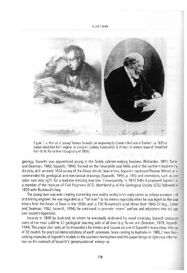
SUSAN TURNER
Figure 1. a. Portrait of young Thomas Sopwith, an engraving by Clement Burlison of Durham ca. 1835 or earlier (modif ied f rom original in Laing Art Gallery, Newcastle). b. Portrait of mature Sopwith (modif ied f rom B. W. Richardson's biography of 1891).
geology, Sopwith was apprenticed young in the family cabinet-making business (Rlchardon 1891; Turner and Dearman, 1980; Sopwith, 1994). Trained on the Newcastle coal fields and In the northern lead-mlning districts, with an early 1824 survey of the Alston district lead mines, Sopwith impressed Thomas Telford, who commended his geological and mechanical drawlngs (Sopwith, 1994; p. 245) and inventions, such as one (plan now missing?) for a lead-ore dressing machine. Consequently, In 1833 Telford proposed Sopwith as a member of the Institute of Civil Engineers (ICE). Membershlp of the Geological Society (GSL) followed in 1835 with Buckland's help.
The young man was ever creating something new and/or useful in his early career as railway surveyor, civil and mining engineer. He was regarded as a "fair man" to his miners especially when he was Agent to the coal miners from the Forest of Dean in the 1830s and to T.W. Beaumont's Lead Mines from 1845-57 (e g., Turner and Dearman, 1982, Sopwith, 1994); he contlnued to promote miners' welfare and educatlon into oíd age (see Sopwith Appendix).
Inspired in 1840 by Buckland, to whom he eventually dedicated his novel creatlons, Sopwith produced
some of the most sublime 3D geological teachlng aids of all time (e.g. Turner and Dearman, 1979, Sopwith, 1994). This paper also looks at his innovatlons for miners and focuses on one of Sopwith's many ideas: the use of 3D models for practlcal demonstrations of earth processes. Since coming to Australia in 1980,1 have been seeklng examples of Sopwlth's models in the southern hemisphere and this paper brings to light new informa-tion on the outreach of Sopwith's 'geoeducational' enterprise.
1 7 8

THOMAS SOPWITH, MINERS' FRIEND: HIS CONTRIBUTIONS TO THE GEOLOGICAL M O D E L - M A K I N G TRADITION
Figure 2. The 1979 Exhibit at the International Englneering Geology Symposium (photos © D r S. Turner).
Appendlx 1 is a first attempt to listThomas Sopwith's inventions, books, papers and reports, etc.
Abbrevlatlons that are used In this paper are as fol-lows: BAAS - British Assoclation for the Advancement of Science; FOD -Forest of Dean; GM - Geological Mu-seum, London; GSL - Geological Society, London; HM - Hancock Museum, Newcastle-upon-Tyne; ICE - Instl-tution of Civil Engineers, London; MEG - Museum of Economic Geology, London; MIB - Museum of Industry, Brussels; MMS - Macleay Museum, Unlversity of Syd-ney; NHM - The Natural History Museum, London NMW - National Museum of Wales, Cardlff; WM - Whlpple Museum of the History of Science Cambridge, UK.
2. BACKGROUND TO STUDY
This paper Is dedicated to W. R. 'Bill' Dearman (1921-2009: Reeves, 2009). I met Bill when I set up the GM 'History of Geological Time' Travelllng exhlbition at HM in the late 1970s and we discovered a mutual interest in the history of geology. I had put out some of the Sopwlth models from our collectlon and also had found a scrap of paper with them, which Bill subsequently recognised as Sopwith's original worklng drawings for his fault model (Dearman and Turner, 1980a, b). His interest in Sopwllh models had begun as an undergraduate at Imperial College and had expanded when he was appointed to Kings College, Unlversity of Durham, where there were sets on dlsplay. We worked together on the ¡mportance of 3D models In early geological science and educatlon, going on to mount a large exhlbition for the Internatio-nal Engineering Geology Symposium at Newcastle In 1979 (Fig. 2). We further investigated Sopwith's large models, precursors and probable Inspiratlonal sources (Dearman, 1979, 1985, Turner and Dearman, 1980a, b, 1982) and trled to find Sopwith's extant large and small models (e.g. Turner, 1979), maklng a tour to vislt Oxford Universlty Geology department, NMW, GM and NHM In London and the Sedgwick Museum In Cambridge (Turner and Dearman, 1982). After I had left England In 1980, Bill examlned the 'Farey models' housed at GSL and as a result we publlshed an explanatlon (Dearman and Turner 1983). Then láter, Bill (Dearman, 1985) wrote
1 7 9

SUSAN TURNER
! E l S 5 l K H l í
an explanation of the Westgarth Forster models at GSL, which he postulated were made around 1821 with the result that Sopwith or his family firm might have been involved in their production given the quality of the workmanship. During this time he was acquiring books and sets of models, which, since his death, have been dispersed again in sales and auc-tions, as at Christies last year (Turner, 2010).
Sopwith's great-great-grandson, Robert Sop-with began the search to relocate the large set-piece models and had brought together an exhibit and accompanying unpublished catalogue at Wel-lington College In 1973; subsequently he wrote a major biography of Thomas (Sopwith 1994). Bill contacted him to seek permission for use of material and quotations from the diaries for our work. Much of the cited detail (Including here) originates from that source and earlier biographies (references In earlier papers). Some of Sopwith's writings are now available on open access; a full llst of his works is probably still to be published (see appendix herein).
Figure 3. a. Levelling party f rom Sopwith; b. Diagram of Sopwith stave: a=sleeve or cap (brass); b=Spring clip (brass); c=stave sections (mahogany) (a-b, modif ied f rom Sopwith, 1994); c. detai l of Almadén Mining Museum Sopwith staff showing mult icoloured woods (photo S. Turner).
3.YOUNG SOPWITH
Sopwith had an unusual education from ca 1810 to 1812; otherwise he was self-taught (Turner and Dearman 1979, Sopwith, 1994). His father, Joseph,
chose to send him to the school of mathematician, astronomer and non-conformist Henry Atkinson (1781— 1829), a leader in Newcastle's Unitarian church, and a leading member of the Newcastle Literary and Philo-sophical Society. As a Newcastle Freeman, father Joseph must have admired the unconformist and democratic ways of this man. With interests in economics, engineering, philosophy, and physics (Gross 2004), Atkinson taught Sopwith observation, measurement, surveying, astronomy with his home telescope. Subsequently So-pwith constructed his own telescope as well as a microscope. One topic Atkinson researched was The possi-büity and ... consequences of the lunar origin of meteoric stones, which shows what might have encouraged Sopwith's interest in the world around him. In all he taught young Sopwith how to think. In 1811 Sopwith also took drawing lessons from the highly regarded Newcastle watercolourist Thomas Miles Richardson Snr (1784-1848) (Sopwith, 1994). Still at school, Sopwith also made his first surveying trip in Newcastle using chain, pencil, notebook and staff. He learnt firsthand the difficulties of using the current surveying staffs (Fig. 3), inaccuracies of measurement and inefficiency on steep gradients.
About 1815, Sopwith was apprenticed to his father's cabinet-making business and further developed his talents, by learning the rudiments of business practice and by honing skills in drawing and model making (Turner and Dearman, 1980). He also began a fascination for minerals and antiquities and taught himself geol-ogy. Sopwith's biographers (e.g. Sopwith, 1994, p. 145) record that in 1830 Sopwith's mentor in geology was
1 8 0
T h O M A S S O ^ A V H , ÍVINERS' FRIFND: H S CONTRIBIJ ' IONS TO THE C.FOIOG'CAL IS/O'JEL-MAfl IVG R A D I T ' O N
a "Reverent" Robert Turner (but was it perhaps Willíam Turner?, a noted Newcastle geo-deric and FG5). After hisapprenticeship, Sopwith submitted his first commission to the Newcastle Corporation, producing a plan for a new gaol. He loved writing, developed interests in architecture and design and published his first book and local drawings in the 1820s (see Appendix).
3.1 Sopwith as Surveyor and Mining Engineer
About 1824, Sopwith was introduced to the lead mining district of Alston, first assisting Joseph Dickinson in surveying the Northern Pennine orefield and then joining him in partnership. Rudwick (1976) noted thatWest-garth Forster (1809) was the first to show structural complexity in sections in his first account of this important mining area and young Sopwith would have immersed himself in this contribution. Forster's pre-1830 set of four moveable models showing effects of faults on mineral veins in the Pennine orefield were made around this time, possibly by Sopwith (Dearman, 1985: GSL Object Collectlon),
Sopwith's antiquarian research and practical knowledge of mining and land surveying led to his work in 1829 on 'Geoiogicai Sections of mines', some hand-coloured. He realised that if the forebears in mining over previous centuries had left such documents, what advantage it would give. Thus Sopwith developed his plan for a reposi-tory of mines and mining data, which eventually was taken up nationally, leading to the formation of the Mining Records Office in connectíon with de la Beche's MEG in the 1830s (Turner and Dearman, 1979; Sopwith, 1994).
At an early stage, Sopwith developed a philosophy of "Do it yourself". He learnt that all knowledge consists in accuracy of observation, faithfulness of recording, and in facility of communication. Mining exploration and rail-ways went hand-ín-hand and Sopwith was at the forefront in his formative years, induding overseas work in Bel-gium in the 1840s and later in 1865 in Spain with his son Thomasat Linares (e.g.Vernon 2009). As a young man he may have been what we would now regard as forceful but as a result of his hard work and creativity, Sopwith won over many and eventually joined the ranks of hígh society induding in his chosen milieu of science (Sopwith, 1994; Thackray, 1999). His first major breakthrough carne in 1833 with Telford's nomination for ICE membership.
3.2 The Sopwith Staff
In 1828, after his early surveying experiences and using his cabinet-making skills, Sopwith decided to construct an improved levellíng stave of telescopic form with a distinctive style of 'reading'. This has proved one of his most enduring inventions. He chose mahogany for the new instrument, following testing in the FOD surveys and formally launched the invention at the BAAS in Newcastle in 1838. Sopwith (1994) described the 14-ft staff of three parts that slide together with the two upper fixed by spring catches (Fig. 3b). Extensión to 16' or 18' was achieved on mountainous land; when closed it is tripod-like '5 feet 4 inches', convenient to stow away under coach or railway carriage seat (Sopwith's typical conveyances). The staff is divided into hundredths of a foot, each alternately coloured black and white wi th feet shown in Iarge red figures, and tenths by Iarge black ores (Fig. 3c). Sopwith's instruction manual was "reprinted chiefly with a view to Gratuitous Instruction by the Author to Mechanics' Institutes and Libraries in Union with the Society of Arts". Others had to purchase it from Mr J.Tennant, 149 Strand London for 6d or 1 shilling by post (Sopwith 1994: p. 32).
4. SOPWITH VISUALISING GEOLOGY
There was a tradition of using models to understand mineraiogy; founding GSL 'father', Conté de Bournon had
1 8 1

SU5A.N TURíVhR
a set of wooden crystal models for demonstration {Lewis and Knill, 2009); similar exist in the Almadén Mining Museum (ST personal observation 2010). The Forster set of four moveable models showing the effect of faults on mineral veins In the Pennine orefield (Dearman, 1985); the 'lively' or 'garish' coloured 3D models, of W.L. Elias Hall (1764-1853) of Castleton were early examples (Turner and Dearman 1980). Richard Cowling Taylor (1789-1851) presented to GSL two plaster of París models ¡llustrating the Pontypool coal dístríct of South Wales. Awarded the Society of Arts Gold Medal in 1830, his models were daimed to be the first of their kind in England; Wendy Cawthorne (GSL, pers. comm. 22 Apríl 2010) confírmed that there is now no trace of these models.
Sopwíth took the expression to a new level. He seems to have used model maklng at an early stage pre-sumably during his apprenticeship and with his design for the new Newcastle gaol when he was 19 (Table 1). His need to explain geology to others in the next phase of his life was undoubtedly important when his lead-mining work prompted his commercial mineral map engravings in 'Geological sections of Holyfíeld, Hudgill Cross Vein Lead Mines, Alston Moorand Teesdale' in 1829, which brought him to the attention of Buckland (Sopwith 1994), who directed much mine-survey work in Wales and the Forest of Dean to him. Sopwith joined GSL in 1835; his Fellowship Certifícate in June has John Phillips as main sponsor along with Sedgwick, W.J. Hamilton, Murchison and Buckland with election on 18 November, and the 10 guinea-fee confirmed in Decem-ber (Sopwith 1994, p. 147). He had had bad rheumatism from March to June during that year and this may have provided time to work on his first major geology model of FOD.
In 1837, Sopwith and colleague John Buddle met Buckland in Oxford on 8 June ."Dr Buckland said that he had been applied to, to recommend someone as a proper person to undertake the Office of Mining Commis-sioner on the part of the Free Miners (in FOD) 'I told them' said the Doctor, 'that they must have nothing short of Newcastle and I named Mr Buddle and yourself" (Sopwith diary in Sopwith 2001). Buckland also used one of Sopwith's drawings of a fossil tree in his BridgewaterTreatise (Sopwith 1994); in turn Sopwith later made the dassic cartoon of Buckland heading in search of evidence of glaciers. Sopwith seemed to agree wholeheartedly with Buckland's view of geology; his later books show that he veered from this to promote uniformitarianism. He was pleased to be supported later by Charles Lyell (see Small models below).
4.1 Sopwith's large models
Taklng up the FOD survey and then the role of Commissioner in the 1830s was the turning point in Sopwith's career as a geologist. This work spurred his translation of geological knowledge into large 3D models in order to explain structure in the workings in economically important coal, lead and iron-ore mining areas (Turner and Dearman, 1982 with appendix listlng models). A Román numeral numbering system used for 13 large geologi-cal models is presumably Sopwith's but It does not help us wi th chronology for all (Turner and Dearman, 1982: Table 1). Sopwith (1994, 2001) discussed and noted entries in Sopwith's diaries with information regarding the FOD, Welsh and other models; a convivial meeting during the 1838 BAAS in the George Inn at Newcastle led to an agreement to produce several models for de la Beche and the buddíng MEG. Over 20 years or so he made around 20 large set pieces. As a consequence of his experience, wood was the obvious manufacturing médium. This was augmented by his skills In 2D map making and his deveíopment in the 1830s of isometrlc drawing techniques. His invention of a portable 'laptop' desk was another key aid allowing him to work during his peripatetic life. In 1831 (or 1832), Sopwith visited a papier-máché factory in the Edgware Road, London and he may also have used this material for models (Sopwith, 1994). Sopwith himself and Turner and Dearman in their papers explained the mode of construction and geology of the various versions. Table 1 provides an updated list with whereabouts; please contact the author with any new information.
1 8 2

THOMAS SOPWITH, MINCRS FRI tND: HIS CONTRIBUTION5 TQ THE GEGLOGICAL MODEL-N 'AKING 7RADITION
Date Subjec t P lace M a t e r i a l C o m m i s s i o n W h e r e
1820s fauHs, mineral veins Forster N England lead mines w o o d Dlckinson, self? G5L
1821/2 XVII Newcastle ci ty/gaol Newcast le uponTyne ? compet l t ion , self
Mewcast le Corporat ion?
1835-7 XIII-IV coal seams, ¡ron Forest of Dean w o o d x 3
Ashmolean; MEG; Ivlilne's idea UM, SM, N H M
1836 rai lway Newcastle 7 Grainger 7
1837 sulphur wel ls geology Fiarrogate papier-maché or wood?
Mr Cresswell, lawyer/ court
Yorkshlre archive?
1837 covered market, t o w n hal l
Thirsk ? Thirsk 7
1837-9 XV
Coal Mcasures, iron ores
EbbwVa le & S¡rhowy S Wales
w o o d x2; one t o MEG in 1843; Harfords
x1 N M W ? proprietors
1839 Isometrical Plan lead-miníng
Part of A ls ton Moor w o o d ? MEG 7
1839 Bolam murder trial Newcast le Bank ? self 7
cal 839 XVI Nentsbury lead mines Cumbr ia 7 one to MEG NHM
1840 XIX
Al t -y-Grug mines survey
S Wales w o o d ? Duke of Beaufort Beaufort Estate?
1840? copper? mines Cornwal l 7 Duchy of Cornwal l 7
1841 small models generai w o o d self; boxed sets wor ld Inc Russla
1840-1 XVIII
geology for Leeds & Thirsk Railway,
near Leeds ? 7
1843 & 1844 boxed small general w o o d
x 2 self to museum & Leopold II
W M , MIB + Belgium
1863 mine safety-cage Alx- la-Chapel le ? self at M in ing Inst i tute
u n k n o w n Hodgl l l Burn Mine, ? Vlr Ti lomas Wi lson 7
unknown Moel Wyn mine N Wales 7 Office Woods & Forests
7
Table 1. üpdated Sopwith model list ( from Turner and Dearman 1982; Sopwith 1994).
One Interesting but misslng model was of the geology of Harrogate's sulphur wells, which was used at a trlal at York, 14 March 1837 where Sopwith gave evidence alongslde John Dalton (Father of chemistry), Willlam Smith, John Phillips, and John Buddle (Sopwith, 1994). This model that was made to explaln geological details to advócate Mr Cresswell might be languishing In an evidence box somewhere in York. The trial also seems to have been Sopwith's Introduction to Willlam Smith; it gave him a great joy to escort Smith In Newcastle later that year.
4.2 Small models
Making the large models probably focused his attention on the need for more general teachlng models (Turner and Dearman, 1982), which are beautifully made and usually housed In a large box In the form of a book (Turner, 2010). Sopwith developed his ¡deas for small stratigraphical models In the late 1830s, with production beginning at the Sopwith workshops in 1840 and development and advertisement of the commercial small
1 8 3

SUSAN TURNER
Figure 4. Sopwith's Model no 1 shown 'operat ing ' in Tennant's advertising example.
geological model setsfrom 1841 (Turner and Dearman, 1979, 1980). The survlving 1840 notebook (Sopwlth 1994: p. 180) relates how he made sketches as he travelled around as In Haltwhlstle and Holy Island on 1 June 1840. The models were shown to frlend and benefactor Buckland who put his seal of approval onto them, re commending about half of 30 posslble blocks. Sopwlth went on to develop boxed sets of 6, 12 and 18 models for sale. He produced his last revlsed set of six models In 1875, sllghtly slmpllfied by reduclng the number of strata represented using thln sheets of exotlc woods (Turner and Dearman, 1980).
Turner and Dearman have looked In detail at how the models were made and what they deplcted. His nephew John Sopwith made the models from his designs and worklng drawings and they were sold elther from Sopwith's of Grey Street, Newcastle or from Mr Tennant's In London. A small book, published In 1841 was intended to accompany the geological models. Turner and Dearman (1979, 1980) and Sopwlth (1994) show the joiners at work on the models on benches with tools for curvlng and planing wood sheets dlsplayed at Sopwith's workshop at Sandyford, ¡neluding Ralph Renwlck and George Muras, who had both worked for his father Jacob or únele Joseph; the worklng drawings for one set were donated to HM In 1904 by Henry Robson of Jesmond (Turner and Dearman, 1980), perhaps one of the workmen.
Sopwlth considered the purpose of the models to Impart elementary vlews, so that he "endeavoured to wrlte In the same terms which I would use In descrlbing them to those who are unacqualnted with geology". Early on the tactlle nature of the models was emphaslsed not least In Lyell's 'advert' (Turner and Dearman, 1980). Tennant's brochure also glves the reader an Immediate sense of how to use the 3D wooden blocks (Flg. 4). The models were published in sets of 6 or 12, as suggested by Buckland, the first six being one series of strata and denudatlon, with the remalning six Illustratlng more complex conditions ¡neluding Intersections of mineral veins (or faulting). Different sizes were made, a hand model of 3" square; 4 " and 8" for lecture purposes, avallable to special order. Comprlsed of 579 separate pieces of wood, they fully justlfied the retall pnce of £2 10 0 shll-llngs for a set of six and £5 for twelve. A set of 12 with two additlonal, smaller models (as at GSL) Is rarely seen.
Sopwlth used a codlng of different coloured woods to show the contrastlng colour of the rocks represented In his models. In reply to D.A. Greenwood who noted Sopwith's use of colour on his maps (stratlgraphical colour code, original W. B. Lead Mine key: Mining Record Office Plan No. 3608), Dearman (In Turner and Dear-man, 1982) said that he was particularly Interested to leam of another example of this device that he used in the FOD model and In the published engraved plans. Patterns of parallel-ruled straight Unes and wavy Unes superimposed In different dlrections were used to show worklngs In up to seven seams In the same area. The
184

• THOMAS SOPWITH, MINERS' FRIEND: HIS CONTRIBUTIONS TO THE GEOLOGICAL M O D E L - M A K I N G TRADITION
r ._ ' i • • 1 • 7"
• f -
. .-T- Y - f ' J
- / " / '
„. , / O f ' -
y . i f í - - — '
. ' •• • •
- -f
, - J ' - - . . . j i '
. . . • r . • -1
M- ' T '
•f! 'I sí.
Figure 5. A. Sopwith models boxed set 1841 GSL set [GSL Object Collection no. 1); B. Greenough (GSL bust: photo ST); C. Greenough's review letter of Sopwith's submitted paper to GSL, 1841 (3 sides; photo ST, courtesy GSL Archives).
MEG versión of Sopwith's map is also coloured but the colours are badly faded. Colour coding was also used for the various lithologies shown on the working drawings for a set of hand models.
4.3 Acceptance - ,
From 1841, Sopwith addressed many societies and other venues on his models, such as at Durham Universi-
1 8 5

SUSAN TURNER
Figure 6. Austral ian-housed boxed set of small Sopwith Models, transferred in 1986 f rom the then Dept of Geology and Geophysics, University of Sydney (photos taken in 2010 and reproduced courtesy o f t h e Macleay Museum, University of Sydney).
ty where he taught engineering and at the local Newcastle natural history society when he was President in 1855. Sopwlth's diaries glve reports on GSL gatherings he attended from 1837 (Thac-kray, 1999) with the relatively small geological circle in Britaln at that time. In 1841 Sopwith exhibited and demonstrated his models with the accompanying drawlngs at ICE explaining the use and construction, mentionlng a papier-máché model of France showing the inequalities of mountains by Schuster, and alludlng to T.B. Jordan's model of Dolcoath Mine, Cornwall (then at MEG). At GSL on 6 January 1841, encouraged
by Buckland, he gave a paper 'On the lllustration of Geological Phaenomena by means of Models', with the series of 30 models lald on the table before the Fellows (Fig. 5a). His colleague John Taylor occupied the Vice Chair. On the President invlting observations, George Bellas Greenough (1778-1855), foundlng father and first President of GSL from 1807-1813 (Fig. 5b), aróse and said that he had a series of models made 'sometlme ago' from Mr. Farey's designs and which he thought had never received from GSL the attention they deserved; he said they were less Instructive than those now on the table but that he would present them to the Society (cf. Dearman and Turner, 1983).
Buckland then addressed the Fellows In a 'very flattering manner' on the valué of the models for geological and mining purposes, mentionlng the FOD model and saying that he considered the 'faclle construction of such models as forming a new era in geological sclence'. After the meeting, several gentlemen examlned the models and James Tennant expressed his convictlon that sets of them would be purchased by students of geology and others (Thackray, 1999). Sopwlth's other business coup was the Lyell recommendation of their use for record-ing and teaching practical geology In his Elements of Geology (figure on p. 61; p. 62 footnote 87) from 1841.
After this lecture, Sopwith wished to publlsh In the transactions. Greenough refereed Sopwlth's submlt-ted manuscript (letter GSL COM P4/2 no 199) and proceeded to wrlte a scathing review (Fig. 5c). Although he warrants that the paper is a valuable and almost indispensable appendage to the models, he reckons that the latter are of the same nature as Farey Snr's dlagrams from which models were made (GSL Object coll 3;-Dearman and Turner, 1983). Greenough, by then perhaps a rather belllcose 63 years, had a vested interest in promoting Farey's models as he had commlssioned them to be made. Greenough also clalmed to see noth-ing new In Sopwith's models even though he reckoned, somewhat perversely, that Sopwith can "lay clalm to origlnality" with the models "well conceived, skilfully constructed and beautlfully executed". Some he saysare the same as Farey's (but see Dearman and Turner, 1983), others must be considered superior. He allows that they are "immensely useful auxiliarles" that might properly appear In the forthcoming volume under Extracts accompanied by a Píate [but did they?]. Greenough finishes by stresslng that the world Is also ¡ndebted to Sopwith for his Invention of isometrical drawing (e.g. Turner and Dearman, 1979). Sopwith must have been
1 8 6
J
fM ' • 01 ^t —a
m W : ^

THOMAS SOPWITH, V1IIVERS' FRIEND: HIS CONTRIRUTIONSTO THE GEOLOGICAL MODEL-fv 'AKING T3ADITION
upset by the tone even ¡f ¡t wasn't outright rejection. It llkely led Sopwith not to publish with GSL and to self publísh in a descriptive book soon afterwards (Sopwith, 1841).
4.4 Far-flung models
Turner and Dearman wrote (1979, 1980) that Sopwith's small models "were adopted by Oxford, Cambridge and London and are still used for teaching at the Geoiogicai Museum, London and in the University of Glas-gow" and listed occurrences. The late 20th century demise of British geology departments presumably resulted in this practice ceasing. A new attempt is needed to track the sets in Britain and elsewhere.
The small model sets were a success if not a great profit-maker. Most known sets are in Britain but they were sold until well into the 20th century, by Ward's scientific suppliers with an undated Descriptive Manual. Sopwith used them for outreach and diplomacy. They were shown to the Prince Consort in May 1842 and sets were presented to the Russian Court via Murchlson; to MIB and Leopold II King of Belgium.They were also a drawcard at the Great Exhibition (Sopwith 1994). Sometimes, however, as many of us still encounter with tak-ing geoiogicai specimens around the world, he had trouble with them, as he had to explain his model sets to Antwerp Customs (they were "not a little bothered with my boxes": Sopwith, 1994, p. 208). His Fellowship of the Royal Society in 1845, perhaps his most cherished achievement in the social sphere of his work, noted his Invention and improvement of dissected models that represented mineral structure.
How far did Sopwith's models get? In the 1978—SOs search (e.g. Turner and Dearman, 1980), we asked if any made their way to Australia or elsewhere in the colonies. This question has only recently been answered (J. Holland, Jan Brazier pers. comms 2005,2010). A boxed set (Fig. 6) was transferred to University of Sydney's MM from the Geology Department in 1986. David Branagan [then Associate Professor who transferred them] wrote to Peter Stanbury [then director of the museum] on 29 May 1986 that these'models were used for teaching for many years in this department and may have been purchased by Professor Liversidge. I have not yet found a record of their purchase.' Archibald Liversidge (1846 -1927) would surely have known Sopwith's models and books before he carne to Australia in 1872 as Reader in Geology. He wasquicklyelevated to Professor and in 1892 founded the universlty's school of mines. At any of these junctures he might have bought his Sopwith set.
5. CONCLUSIONS
The founding document of the GS made It dear that the ordinary man in the street', could contribute to geol-ogy as, "the necessary data can be colfected by anyone: 'the Miner, the Quarrier, the Surveyor, the Engineer, the Collier, the Iron Master, and even theTraveller' "(Geoiogicai Society, 1808a, p. 2 in Lewis and Knell, 2007). Wearing almost all these hats, Thomas Sopwith M.A., FRS, CE, achleved this in good measure. He was con-nected with mining ventures, rail and road building, publishing maps, books and articles. Sopwith also contrib-uted to scientific endeavour in many ways, not Ieast with his fine geoiogicai models, Iarge and small. These and his surveying staff ¡Ilústrate the conjunction of his training in cabinet making and his early career in surveying.
At the age of 42, and after years of extensive travelling on railway and mining surveys, Sopwith gladly accept-ed the offer by MrT. W. Beaumont to become Chief Agent for the W. B. Lead Mines at Allenheads. There he made a major impact on the Company's operations from 1845 on. At this time all (except probably Sopwith) thought that the mines were nearly exhausted; Sopwith proved that the mines were viable (foreign competition finally forced dosure in about 1875). His development of a system of mine surveying and plan preparation provided not only details of location and level but also induded detailed geoiogicai information that has been claimed as
1 8 7

SÜSAfj TURNER
some of the earliest, ¡f not the first mine geological plans ¡n the world (Turner and Dearman 1982). Greenwood (¡n Turner and Dearman, 1982) made this fitting tribute to Sopwlth noting that his plans were sufficiently precise and detailed to permit modem stress-trajectory analysis wi th results that coincided exactly with recent joint-orientation measurements, thus providing yet another example of Sopwith's exceptlonally high standard of work.
Sopwith entered the inner sanctum of élite' geologists in early 19th-century Britain even if he is no longer remembered as a major figure in the history of geology, and even though he can lay claim to be one of the first geological teachers whose work has stood the test of time. The work done in the 1970s-80s by Dearman (and with the author) to resurrect the early history of geological models put Sopwith's achievements, along with those of his predecessors back into the limelight; there is renewed interest In the role of models in the history of science and Sopwith's examples are now appearing on the internet and in auction houses. Information about the missing ones is still sought.
Sopwith was paramount in ensuring the education, safety and viability of mines and miners under his care, and in the founding of the Mining Records Office. In his dealings with men, his intelligence and fairness shine through.
ACKNOWLEDGEMENTS
I thank my family, the INHIGEO Board, Jan Brazier, Norman Butcher, Wendy Cawthorne, Julián Holland, Claus Jung, Bill Kitson, Kaye Nardella, Eric Pirard, George Reeves, Tom Sharpe, Robert Sopwith, lan Rolfe, and Hugh Torrens for help and support.
REFERENCES
Dearman, W.R. 1985. The Westgarth Forster fault models. Proceedings ofthe Geological Association, 96 (2), 97-107. Dearman, W.R. andTurner, S. 1980a. Discovery of work ing drawings for the Sopwith models of 1841 at the Hancock Museum.
The Geological Curator, 2 (8), 467-95. Dearman, W.R. and Turner, S„ 1980b. Sopwith's fault models. The Geological Curator, 2 (9- 10), 593-97. Dearman, W.R. andTurner, S., 1983. Models ¡llustratíng John Farey's figures of Stratified Masses. Proceedings ofthe Geological
Association, 94 (2), 97-104. Lewis, C.L.E. and Knell, S.J. 2009. The Making of the Geological Society of London. Geological Society, London, Special
Publicaron, 317, 571 pp. Reeves, G. 2009. William Robert Dearman 1921-2009. Geological Society, London Annual Report for 2008, 29 pp. Richardson, B.W. 1891. Thomas Sopwith, M.A., F.R.S. Longmans, Green & Co„ London, 400 pp. Rudwíck, M.J.S. 1976.The emergenceof a visual language for geological science 1760-1840. Histórica! Science, XIV, 149-195. Sopwith, R. 1994. Thomas Sopwith Surveyor. An exercise in Self-Help. The Pentland Press, Edinburgh, 266 pp. Sopwith, R. 2001. Thomas Sopwith and the Forest of Dean 1832-1841: "Noth ing short of Newcast le". Bulletin ofthe Peak
District Mining HistóricaI Society, 14, 6-7. Thackray, J.C, 1999. To see the Feí/ows fight: eyewitness accounts of meetings of the Geological Society of London and its Club,
1822-1868. British Society for the History of Science, Monograph 12, Faringdon, Oxon, 243 pp. Turner, S. 1979. Sopwith, Thomas (1803-1879). Geological Curators Group Newsletter, 2 (2), 187. Turner, S. 2010. Thomas Sopwith, the miner's friend: his contribution to the geological model-making tradition. INHIGEO-2010,
Jo/y 7-14, Madrid-Almadén-lberian Pyritic Belt, Spain 'History of Research in Mineral Resources", SEDPGYM, EUPA, Min. Ciencia e Innovation, tnst Geol. y Minero de España, Madrid, Abstracts, 47.
1 8 8

THOMAS SOPWITH, MINERS' FRIEN3: HIS COMRIB ' JT IONS T ü TUL G i O L O G I C A L M O D F I - M A K I N G T R A D I T I O N
Turner, S, and Dearman, W.R. 1979. Sopwith's Geological Models, Les maquettes gáologiques de Sopwith. Bulletin International Associatíon of Engineering Geoiogists, 19, 331-345.
Turner, S. and Dearman, W.R. 1980, The early history of geological models. Bulletin of the International Association of Engineering Geology, 21,202-10.
Turner, S, and Dearman, W.R. 1982.Thomas Sopwith's large geological models. Proceedings ofthe Yorkshire Geological Society, 44,1-28.
Vernon, R. 2009. The Linares Lead Mining D i s t r k t t h e English connection. De Re Metallica, 13,1-13.
Appendix
Sopwith's oeuvre, excluding models, drawn from biographers' citations (e.g., Richardson 1891; Turner & Dearman 1980; Sopwith 1994) and pdfs available on the Internet. Listed in approximate chronologlcal order with dates provlded when known or precise.
Sopwith,! 1821/2. Plan for new Newcastle gaol - design won 2nd place toDobson and 10 guineas, ¡in Treatise on Isometrical drawing 18381.
Sopwith,T, c, 1825-1828. Memorándum of Wews. A notebook of sketches and architectural no tes . - ncludes Jacob Sopwith's Mahogany Yard at Palnterheugh Newcastle, a sketch drawn and etched by TS [ín Sopwith 1994 p. 2 and others; original held by Robert Sopwith,
Sopwith, T. 1820s. Drawings ¡n Robert Surtees History of Durham |Sopwith 1994] Sopwith, T. 1826, Autobiography, Self-portrait. Sopwith, T. 1826a. Historical and descriptivo account ofAll Saints' Church, in Newcastle upon Tyne, illustrated with plans,
wews, and architectural details, including an account of the monuments, with armorial bearings, etc. John Weale, Taylor's Architectural Líbrary, London. [includes R.Thornton'sTomb]
Sopwith, T. 1826-1875. Diaries. [e.g. RS 1994; University of Newcastle upon Tyne, 16 reels of microfilm], All original 168 volumes now held by Robert Sopwith.
Sopwith, T. 1327-1832. Drawings in J. Hodgson's 1832. History of Northumberland pt 2, vol. 2. Newcastle, 599 pp [see pp vii-viii]; Titie page Morpeth Church; p. 184 Woodhorn Church; p. 204 Cresswell Tower, &c; p. 205 Cresswell Fossil tree (1830); p. 214 Newbigging (sic) Chapel; p. 279 Stannlngton Church; p. 384 Gateway of Morpeth; p. 395 Ulgham Chapel; Píate R.Thornton'sTomb.
Sopwith, T, 1829. Plans of Mexican mines. For Mr John Taylor. Sopwith, T. 1829a. Geological sections of Holyfield, Hudgill Cross Vein and Silver-band Lead Mines, ín Alston Moor and
Teesdale, showing the various strata and subterranean operations. Engraved on three copper-plates. Edward Walker, Newcastle, 11 pp, & John Weale, Taylor's Architectural Library, London,
Sopwith, T. 1829, The burning of York Minster. Newcastle Courier, February 13th, Sopwith, T. 1832. Eight Views of Fountains Abbey, intended to iIlústrate the architectural and picturesque beauties of that
celebrated ruin, with historical and architectural description. Newcastle, fol. 2. & John Weale, Taylor's Architectural Library, London, Royal folio.
Sopwith, T, 1832a, Plan of the Vale of Derwent, near Newcastle, showing the new Line of Road; "shewing present and proposed lines ofTurnpike Road", byThomas Sopwith. Printed. Engraved byW. Collard. Paper, coloured, 28" x 15". Scale: 2 " to mile. With sketch of comparative levels of roads, with an accompanying 1-page Letter-press description.
Sopwith, T, 1833, An account of the mining distrícts of Alston Moor, Weardaie and Teesdale, in Cumberland and Durham; comprising descriptive sketches of the scenery, antíquities, geology and mining operations in the upper dales of the rivers Tyne, Wear and Tees. W. Davison, Alnwick, w i th map, 183pp & John Weale, Taylor's Architectural Library, London (published by Davis Books 1984 & reprinted 1989).
1 8 9

SUSAN TURNER
Sopwith, T. 1833a. Plan ofthe mining distrícts ofAlston Moor, with part ofthe Dales ofthe Tyne, Wearand Tees, and the several New Lines ofRoad recentiy made in these districts. John Weale, London, plaln and coloured.
Sopwith, T. 1834. A Treatlse on Isometrical Drawing, as applicable to geological and mining plans, picturesque delineation of ornamental grounds, perspectiva views and workmg plans of buildíngs and machinery, and to genera) purposes of Civil Engineering, with details of ¡mproved methods of preserving plans and records of subterranean operations in mining districts, John Weafe, Taylor's Archi teaural Library, London, 239 pp + 35 copper-plate engravings, 8vo.
Sopwith, T. 1834a. A Set of Projecting and Parallel Rulers, invented by T. Sopwith, for constructing Plans and Drawings in Isometrical and other Modes of Projection. John Weale, London.
Sopwlth, T. 1834b. Descrlption and useof an Improved levelling staff. Letter-press to accompany Improved levelling staff. John Weale, London.
Sopwith, T. 1835. Plan of the coal and iron mine districts in the Forest of Dean, county of Gloucester. Surveyed by order of Her Majesty's Commissioners of Woods, Forestsand Land Revenues by T. Sopwlth, F.G.S., 1835. Engraved under the direction of John Buddle, Thomas Sopwith and John Probyn, Dean Forest Mining Commissioners by W. Collard, Mewcastle upon Tyne. Scale 8 chalns to an ¡nch. Sheets 1-16.
Sopwlth, T. 1836. Civil and Mining Engineering. Mining Review, XX, pp. Sopwith, T. 1837. Observations on Surveying, Planning and Computing the Area of Extensive Districts, with Reference to
Surveys for the Commutatlons of Tithes, and to the Practicability and Advantages of a Natural Survey. Publisher? Sopwith, T, 1837a. Report on Durham mine leases sent to Chancellor of Exchequer. Sopwith, T. 1837b. Cresswell Fossil in: Buckland, W. Geology & Mineralogy Considered with reference to Natural Theology. 2
Vols, Wil l lam Pickering, London. Sopwlth, T, 1838, Treatise on proposed Line of Road from Shotley Bhdge to Middleton-in-Teesdale, w i th map. Sopwith, T, 1838a. Treatise on isometrical drawing. John Wea1 e, London, 2nd Edtn, 224 pp. + 35 plates. Sopwith, I. 1838b. On the appl¡catión of Isometrical projection to geological plans and sections, w i th descriptive notlces of the
mining district at Nentsberry, In the county of Cumberland. Trans. Nat. Hist. Soc. Northumberland, Durham and Newcastle upon Tyne, 2, 277-284.
S o p w i t h , ! 1838c. Model of Forest of Dean. Archive collectlon IGS, 1/687, 53 pp. MS. Sopwith, T. 1838d. Stranger's Pocket Gulde to Neivcásí ie-upon-íyne and its Environs. For BAAS, Newcastle, pp? Sopwith, T, 1838d. Geological map of coalfields, and lead mining districts in Newcastle district for John Buddle's lecture. 8th
BAAS in Newcastle (Report 8th BAAS p. 74). Sopwith, T. 1838e, Lectures and model exhlbition to the 8th BAAS in Newcastle upon Tyne, August [see Reports under 1839 below], Sopwlth, T. 1838f. General Notes on My First visit to Ireland. ¡September mineral survey] Sopwith,T. ca l 838 . fssays on the Principies of Design. mss [Sopwith 1994, p. 240], Sopwith, T, 1839, On sections of the Mountaln Limestone Formatlon in Alston Moor, exhlbitlng the general uniformity o f the
several beds. Report of the Eighth Meeting ofthe British Associatlon for the Advancement of Science held at Newcastle upon Tyne in August 1838, vol VII, Notices and Abstracts of Communications, p. 79.
Sopwith, T. 1839a, On the construction of geological models. Report of the Eighth Meeting of the British Association for the Advancement of Science held at Newcastle upon Tyne in August 1838, vol VII, Notices and Abstracts of Communications, 94-95.
Sopwith, T, 1839b. Descrlption of an improved leveling stavefor subterranean as wel l as surface levellng. Report of the Eighth Meeting of the British Association for the Advancement of Science held at Newcastle upon Tyne in August 1838, vol VII, Notlces and Abstracts of Communications, 154-155.
Sopwith, T, 1339c. Description of instruments to facilítate the process of isometrical projection, Report o f t he Eighth Meeting of the British Association for the Advancement of Science held a t Newcastle upon Tyne in August 1838, voi Vil, Notices and Abstracts of Communications, p. 155.
1 9 0

T H O M A S SOPWITH, MINERS' TR END: HIS CON1RIBUTIONS TO THE: GEOI OGICAL f v O D E L - M A K I N G I K A 3 I T I O N
Sopwith, T, 1839d. On an impraved method of constructing Iarge tables or writing-cabinets, adapted to save much time, and adapted to secure a systematic arrangement of a great number and variety of papers. Report of the Eighth Meeting of the British Association for the Advancement of Science held at Newcastle upon Tyne mAugust 1838, vol VII, Notices and Abstracts of Communications, p. 156,
Sopwith, T. 1839e. Suggestlons on the practicability and importance of preserving National Mining Records. Report of the Eighth Meeting of the British Association for the Advancement of Science held af Newcastle upon Tyne in August 1838, voi VII, Notices and Abstracts of Communications, 156-157.
Sopwith, T. 1830s? Design for covered market atThlrsk [Sopwith 1994, no date given] Sopwith, T. 1840. Report and Char to f religlous institutions in Newcastle S district to reflect moráis of miners [for Rev. Wil l iam
Turner via Rev. John Alien re education of miners: Sopwith 1994, p, 182-3] Sopwith, T. 1840a. Wil l iam Buckland in search of Glatiers. Cartoon. Sopwith, T. 1840? Report on Survey of Duchy of Comwal l mines. [Sopwith 1994, p. 201] Sopwith, T, ca1841. Description ofMonocleid Writing Cabinets. Newcastle, 8vo. 4. Sopwi th , ! 1841. Description ofa series of geoiogicai models. J. Blackwell and Co Newcastle-upon-Tyne, 84pp. Sopwith, T. 1841 a. TheAward of the Dean Forest Mining Commissioners (under 1838 Act of 1 and 2 Victoria, cap. 43) as to the
Coal and Iron Mines in Her Majesty's Forest ofDea n, with the Rules and Reguiations forworking the same: wi th preliminary observations, and an explanation of a series of sixteen engraved plans of the Dean Forest mines, byThomas Sopwith, F.G.S. Commlssioner appointed on behalf of the Crown. J. Weaie, London, iv, [51-209 pp. + folded leaf of plates & map.
Sopwith, T. 1841 b. Geoiogicai Sections of Railway Cuttings. Minutes of the Proceedings, Royal Inshtute of Civil Engineers, 1, Issue 1841,61-62 .
Sopwith, T. 1841c. Explanation of models for famillarly explaining geoiogicai phenomena. Minutes of the Proceedings, Royal institute of Civil Engineers, 1, Issue 1841, 62-63.
Sopwith, T. 1841d. On the construction and use of geoiogicai models in connectlon wi th civil engineering. Minutes of the Proceedings, Royal Institute of Civil Engineers, 1,Issue 1841 ,163 - 1 6 6 [+discusslon by Buckland to 168],
(Sopwith's 1841b, c, d ICE paper available via w w w ] Sopwith, T. 1841 e. Lecture to the on the importance of preserving railway sections, British Association for the Advancement of
Science, York & at Wakefield (see below). Sopwith, T. 1842. On the Preservaron of Railway Sections, and of Accounts of Borings, Sinklngs, &c. Proceedings of the
Geoiogicai and Polytechnic Society of the West Riding of Yorkshire, (1839-42) 1, 315-331. Sopwith, T, 1842. Report on Duchy of Comwal l Mines near Radstock. Discussed with (TS), and given to Punce Albert, Prince
Consort by Buckland May 5th [RS p. 168] Sopwith, T. 1843. Account of the Museum of Economic Geology and Mining Records Office. Established by Government in the
department ofHer Majesty's Commissioners ofWoods and Forests under direction of Sir Henry de La Beche FR.S. John Murray, London, 120 pp. 8vo.
Sopwith, T, 1843a. Memorials for John Buddle and J.C. Loudon, where? [Sopwith 1994] Sopwith,T. 1843b. Report on Norton Hill mine In Somerset on behalf of Dean and Chapter of Christ Church Oxford [Le. Wil l iam
Buckland] Sopwith, T. 1844. The Wationa/ Importance of Preserving Mining Records. John Weale, London & Finlay and Charlton,
Newcastle, 59 pp. 8vo. Sopwith, T. 1844a. Education its currcnt state and future advancement. Tract, Newcastle, 8vo, 40 pp. Cubbitt, W. and Sopwith, T. 1344, Report on the railway project from the Sambre to the Meuse, Belgium. Sopwith, T. 184S. Report w i th new plans for West Flanders railways. [RS 1994 p. 219-220] Sopwith, T. 1846. Observations addressed to the miners and other workmen employed in Mr Beaumont's Lead Mines in East
and West Alíendale and Weardale education and progress of those under his supervisión.
1 9 1

S I S A N T L R N E R
Sopwith, T. 1853. Practica! Observations on Surveying and Levelling. J. Tennant, Strand, London. Sopwith, T. 1853 Education its current state and future advancement. Tract, Newcastle, 8vo. 40 pp. [2nd edition] Sopwith, T. 1857. The Feriy at Kaffre Azzayat on the River Nile, wi th isometrical drawings. Proceedings Royal Institute of Civil
Enginee rs. Sopwith, T. 1857. Notes of a Visit to Egypt, by Paris, Lyons, Nismes, Marseilles and Toulori, T. Sopwith, London, 207 pp -
erratum, 8vo. Pnnted for Private Circulation. Sopwith, T. 1859 to 1860. Installation in Northern England of meteoroiogical stations w i th the Duke of Morthumberland. Sopwith, T. 1860. A Month in Switzerland. [visit to SwiLzerland, France, Italy]. Printed for Private Circulation. Sopwith, T. 1860. Meteoroiogical Coast stations. where? S o p w i t h , ! 1860? On the practical importance of meteorology. British Meterological Society? Sopwith, 1 1 8 6 1 . W e a t h e r Map designed for The Daily Weather Map Company. John Betts, London. Sopwith, T. 1862. A Place of Darkness and in the Deep. St James' Magazine. Sopwith, T. 1864. Lead mining districts of the North of England. Transacf/ons o f the North of England Mining Institute, 13,186-
199, wi th píate XVL [Section of Strata f rom the Fell Top Limestone To The Lowest Strata In The Lead Mines At Allenlieads at scale of Nature (100 feet to 1 inch); paper given October 6th 1863.
Sopwith, T. 1864. On the Geology of Weardale, British Association for the Advancement of Science Report for 1863? and Proceedings of the North of England Mining Instituto.
Sopwith, T. et al. 1865. Discussion of the paper on Lead mining districts of the North of England, Transactions of the North of England Mining Institute 14, 9-14.
Sopwith, T. 1865a. Notes ofa Visit to France and Spain. Hexhatn, 8vo. 9. Sopwith, T. 1868. Education in Viilage Schoois. London, 8vo, Sopwith, Tilomas 1869. Three Weeks in Central Europe. Notes on an excursión including the cities of Treves, Nuremberg,
Leipzig, Dresden, Freiberg, and Berlín. Wi th ll lustrations.Willis, Sotheran, and Co„ London, 135 pp. Sopwith, T. ca 1871. Remimscences. Self-published. Newcastle. Sopwith, T. 1875. Description of a Seríes of Elementary Geological Models íllustrating the Nature of Stratification, Vafieys of
Damnation, the effects produced by Faults or dislocation, intersection of mineral veins, etc. R.J. Mitchell & Sons, London, 82pp.
Sopwith, T. 1876. A tour through Normandy and Brittany, ms.
1 9 2

J. £. Ortiz, 0. Puche, I, Rábano a r d L , " Mazad iego (eds.) Hstay of (¡swch :n M inera / ( f raudes- Cuadernos riel M u s e o Geomlnero , 13 Instituto Geológico y M ine ro de España, Madr id , ISBK 9 7 8 - 8 4 - 7 8 4 0 - 8 5 6 - 6 0 instituto Geológico y M ine ro de Espara 2 0 1 1
GEOLOGISTS AND THE BURRA COPPER BOOM, SOUTH AUSTRALIA, 1845-1851
Barry J. Cooper
School of Natura and Buil t Environ-nents, Uri lversl ty of South Austra l ia , GPO Box 2471 , Ade la lde SA 5001 Aust ra l ia ba r r y . coaper@i rn l sa .edu .o j
Abst rac t . Australia's first min ing boom occurred in South Austral ia dur ing the years 1845-1851, fo l lowing a major copper discovery at Burra ¡n 1845. The discovery also brought the miqrat ion and first concent raron of experts w i th geological and mining knowledge to Australia. This ex-pertise had three main origlns: an educated ellte f rom Great Britain, practical miners f rom the English county of Comwal l , and a group w i th both professional and practical experience f rom Germany. As a result of the Burra copper boom, numerous scientific reports were published, including the first geology book (and Government geological report) to be printed in Australia. At this t ime South Australia was also a base for geologists moving more widely around Australia. Wi th the discovery of gold in Victoria In 1851, min ing developments in South Australia were overshadowed. Most geologists, then based in South Australia, left the colony and jolned the gold rush. The initial gold discovery in Victoria has been at t r ibuted to the efforts of a Germán ge-ologist, G.H. Bruhn, w h o was first based in South Australia at the t ime of the Burra copper boom.
1. INTRODUCTION
Much of Australia's history since European colonisation has been dominated by mining and its associated developments. Gold mining in the latter half of the nineteenth century formed the springboard from which the modern nation of Australia evolved, whilst ¡ron ore, coal and other mineral product extraction have argua-bly been the major drivers of Australian economic development since the 1960s. In this paper, we focus on Australia's earliest mining era, the little known "Burra Copper Boom" in South Australia 1845-1851 and the geologists from this period.
Whilst the first significant copper deposit in South Australia, and Australia generally, was discovered at Kapunda in 1842, the discovery of the " Monster Mine" at Burra in 1845 heralded Australia's first mineral boom (See Figure 1, Locality Map). Quickly the South Australian community was beset by "coppermania". Many ad-ditlonal small mines were established over the next five years. By 1850, the township of Burra was the largest inland settlement in Australia, more than double the size of the current major cities of Perth and Brisbane. Kapunda was also a town with significant population. At the same time, mineral products accounted for more than two thirds of South Australia's exports.
2. BACKGROUND TO THE BOOM
The Burra copper boom and the preceding foundation period in South Australia brought the first significant
1 9 3

BARRY J CQOPER
influx of people wi th geological and mining knowledge to Australia. This event initially reflected the fact that South Australia, as a British- colony, was distinctly different from other early British settlements ín Australia, most of which had a function and economy based on convicted criminal (i.e. convlct) labour expelled from Great Britain. In contrast South Australia was established in 1836 as a free colony under a separate Act of British Parllament and was a planned commercial enterprise with a founding colonisation company. (It served as a model for the similar colony in Canterbury, New Zealand, which was founded in 1850.)
The importance of geology to the founding enterprise is well illustrated by the efforts of the "South Aus-tralian Literary and Scientific Society", which met in London before establishment of the colony. At its second meeting held on 12 September 1834, the principal lecture was on "The Geology of Australia" (Minutes Book of the South Australian Literary Association-South Australian Archives). O'Neil (1982, p. 7) also records that as early as 1835 a public company was planned in England with an objective of exploring for minerals in the yet-to-be-established colony of South Australia.
In July 1836, the founding "South Australian Company" appointed a "Mine and Quarry Agent and Geologist", Johannes Menge. He is also certainly the first persoti to hold the title of "geologist" in South Australia (Cooper et al., 1986) and possibly in Australia as a whole. Despite dismissal from his post in 1838, Menge remained active in South Australia as an independent agent and promoter of mineral exploration and development until 1852. In this role he published numerous mineral lists as well as a series of artides dealing wi th geology in the local press (Menge, 1841a,b). In addition, Menge (1848) provided a descrip-tion of his mineral exploration and assessment process. More recently, Menge has been given the sobri-
quet of "Father of South Australian Mineralogy" (Auhl and Marflett, 1975; O'Neil 1988). It is suggested here that Menge may be more gener ously labelled the "Father of Australian Mineral Exploration".
South Australia's colonial administrators also played an early role ín describing the geology of South Australia. The colony's second Governor, George Gawler (1838-1841), even made some geological contrlbutions (e.g. Gawler, 1839, 1841). With the colony's foundation, surveyors were also instructed to assess land for their min-eral resources with the first Surveyor General, Wil-liarm Light, and his staff being requested to site the capital near water, coal and building stone resources (O'Neil, 1982, p.8). This tradltion con-tinued after Light, and during the 1840s Surveyor General Edward Frome reported on the geology during exploration (e.g. Frome, 1843) and provid-ed instructions to his staff to make geological ob-servations. His Deputy Surveyor General, Thomas Burr, made a significant contrlbution in this re-gard, an early geological report being his accounl of exploration in the South Australia's southeast reglón in 1844 (Burr, 1845).
''i • U J S T F A L
t„ • N r
A D C I . A D E J S ™ .
¡nvcstigalor Stf&t
Kangaroo «sland
Figure 1. Locality map
1 9 4

GÉÜLOGISTSWNDTHE BURRA GSPPER B O O M , SOUTH AUSTRALIA, 1 8 4 5 - 1 8 5 1
3. DEVELOPING "COPPERMANIA"
From the beginning of colonisation, South Australians established quarries for building stones. By 1840, further interest in the development of mineral resources was evinced through the establishment of slate quarrying atWillunga, about 50km due south of Adelaide. Slightly earlier, and more significantly, traces of copper were recognised in 1838 in the hills only 10 km southeast from the centre of Adelaide at Glen Osmond. Both and Drew (2008) have discussed the different discovery accounts of this deposit and how it led to first Australia's metalliferous mine in 1841.
Figure 2. Kapunda copper mine 1847 (Lithograph after G.F. Angas, Art Gallery of South Australia). Figure 3. Burra Mine showing chief port ion of surface operations, 1850 (Paintlng by S.T. Gilí, Art Gallery of South Australia). Figure 4. Penny's Stopes, Burra Mine 1847 (Painting by S.T. Gilí, Art Gallery of South Australia). Figure 5. Glen Osmond Mine 1845 (Painting by S.T. Gilí, Art Gallery of South Australia). Figure 6. Opening of the Karkulto copper lode, 22 km south of Burra 1850 (Painting by S.T. Gilí, Art Gallery of South Australia).
1 9 5

BrtRRY J. COOPER
The discovery of the first large metalllferous resource, the Kapunda copper deposit, occurred ¡n 1842. The mine was formally opened by Menge in January 1844, who also located another copper deposit in the surrounding región (Dutton, 1846, p. 287}. Auhl (1986, p. 31) notes that by the end of 1844, there were exhibitions of South Australian ores in Sydney and Meibourne and, soon after, there was some consequential emigration into South Australia from the eastern colonies.
The recognltion of valuable minerals also concerned the Government because, glven the system of land sales and tenure initially establlshed in South Australia, which invested mineral ownership with land owner-ship, their occurrence elevated the valué of land. As early as 1840, a directive from London had ordered that potential mineral land "needed to be inspected by a Government Geologist and Mineral Surveyor". However no action was taken on this request until after the Burra discovery, even though Menge had expressed interest in a position of "colonial geologist" as early as 1841 (O'Neil, 1982, p 17).
In the period leading up to the discovery of Burra, there were others who were also interested in the geol-ogy and minerals o f the new colony. A paper entitled "Geology of South Australia No. 1" was "read before the Council of the Adelaide Institute January 27 ,1843" by B.T. Finniss (1843). Additional parts to the Finniss's con-tribution are not known, even though Finniss became a prominent South Australian public servant, and in 1856 the first Premier of the colony. Information on the geology of South Australia was also provided anonymously both to reporters in Great Britain (e.g. Binney, 1842) and in South Australia (Anón., 1843, 1844). And follow-ing the Kapunda discovery, its joint owner, F.S. Dutton (1846), published in London an extensive description, which publicised the developlng copper province. It also gave due credlt to Menge, Burr and another geologist, C.D. Fortnum. Fortnum is not known from any other source dealing with the geology of South Australia but is quoted at length by Dutton as a "chemist and mineraloglst". In Dutton's book, Fortnum not only provided a description of the Montacute and Mukurta copper deposits but also considered in general the prospects for ¡ron ore and coal occurrence. All these contributions confirm that geological expertise was available in South Australia from the outset, from an educated British elite In the colony. It was utilised in the developing mineral boom.
4. THE BURRA COPPER BOOM
The discovery o f t h e gigantic copper deposit at Burra In June 1845, the so called "Monster Mine", directed worldwide attention Lo the mineral resources of South Australia (and Australia generally) for the first time. The Burra Copper discovery also proved to be a magnet for many with geological expertise,
Soon after discovery, the second accountant at the South Australian Banking Company, John C. Dixon, wrote an official report on Burra mine geology for the mine purchasers (Dixon, 1846). Not only was this report published and dlstributed In Britain, It was also translated into Germán and circulated on continental Europe.
The Burra discovery also forced action by the Colonial Government, as in May 1846 Governor Frederick Robe assigned Deputy Surveyor General Burr to the new position of Mineral Surveyor. About the same time as his assignment Burr also published a thirty-two page book (Burr, 1846) that is today regarded as the first geol-ogy book published in Australia and certainly the first government geological report of any kind in the country (Cooper 1984). A succinct overview of South Australian geology was provided, in which rocks of Cambrian age were identifled for the first time In Australia (Cooper and Jago, 2007). Burr's work responsibilities, emphaslsing mineral resource assessment, also created what is arguably Austraiia's first Geological Survey (1846-1852) (Cooper 1985). Even though he left Government employment in October 1847 to accept an appointment as General Superintendent of the Burra mine, Burr was succeeded in his role by James Trewartha (1847-1850)
1 9 6

G E O L O G O S A N D 'HE BURRA COPPFR B C O M , SOUIH AUSTRALIA, ' 8 ¿ 5 - 1 8 5 1
and Benjamín Babbage (1851-1852), before these geological/mining appolntments lapsed. Trewartha's min-eral survey reports were published in the official Government Gazette as well as in the local press. Trewartha (1849), in additlon to mineral survey reports, also discussed "the principal rocks of South Australia" from his personal experíence. Trewartha (1850) provided comment on mineral deposits In Cornwall and South America (mostly Columbia) and extended his comments to South Australia, where he mterpreted correctiy that many South Australian copper deposits do not extend at depth below an enriched zone.
The Burra Copper Boom also attracted unattached geologists who undertook geological and mineral as-sessment as a consequence of the increasing number of mineral discoveries, The resident populatlon generaily quickly learned to recognise mineral indications, for example the colours of oxidised copper minerals, butexpert geological and mineral knowledge was sought to prove an economic resource and to establish ongoing min-ing operations, By the end of 1850, It was recorded that there were forty-nine separate active metal mining operations In South Australia with thirty-eight individual copper mines. Although the Burra and Kapunda mines domlnated the economy, it Is notable that other operations also employed significant people. For example, It was reported that there were eighty-six people at a remote Eyre Península mining operation in the far west of South Australia in July 1849 (First Annual Report of the Port Lincoln Mining Company. South Australian Gazette and Mining Journal 26 July 1849).
A significant feature of the geological expertise that entered South Australia was Its association with the English county of Cornwall. From the earlíest years of the colony, Cornlsh migrants entered South Australia in the role of well diggers and general labourers. According to Johns (2006) the decline in tin and copper min-ing In Cornwall at this time coupled with the offer of a free passage to South Australia and the prospect of improved living conditions stlmulated this migration. With the discovery of metallic minerals, Dutton (1846) noted that it was an easy step to persuade the Cornish migrants to enter mining enterprlses, given their mining associations. Moreover, It was a simple step to promote additlonal Cornish migratlon to assist mine develop-ment. Whilst the majority of Cornish miners were mine workers, there were also those who possessed signifi-cant expertise both in geological, mineral assessment and mine management skills. The Government Mineral Surveyor, James Trewartha, was of Cornish heritage and Cornish mining was discussed In his reports. Also of Cornish heritage was Henry Roach, who took over management of the Burra Mine following the dlsmissal of Thomas Burr in 1848 and who held this position until 1867 (Auhl, 1986). In addltion there were numerous min-ing experts from the 1845-1852 period who had likely Cornish heritage, given that In reports that they were accorded the Cornish tltle of "Mine Captain". Individuáis, ¡ncluded here, are Captains John Pascoe, Thomas Peters, John Phillips, Richard Rodda and John Alsop.
Another source of geological knowledge for the Burra copper boom was Germany. Johannes Menge was Germán In origin and his early appearance in South Australian history probably results from the special liaison that the South Australian Company Director, George Fife Angus, developed with potential Germán immigrants, especia ly religious refugees (Pike, 1967, pp. 130-131, 208-211). Within a decade, Germans also left their homeland for South Australia as a consequence of political and economic factors. Following the Burra copper discovery, further geological expertise was sourced from Germany by the operatlng mining company and a "mineralogíst", Dr Ferdinand Von Sommer, was employed to make drawings of the mining field (South Austral-ian Gazette and Mining Journal 18 October 1845). In 1848, another Germán, Dr Georg Bruhn, was advertlsing his services asa mlneralogist, geologist, miner and chemist in Adelaide (see advertisement in the South Austral-ian Gazette and Mining Journal 29 Aprll 1848) and provided his views on coal occurrence in South Australia (Bruhn 1848). Later he sourced local capital to finance an exploration expedition and his substantial report was published as a special supplement in the local press (Bruhn, 1849). By 1850, Cari Zaccharie was heading a group of Germán miners operating the Wheal Gawler mine at Glen Osmond. His geological report, which
1 9 7

BARRV J. COOPER
was originally written in Germán and published in the local German-language newspaper, was subsequently translated and published In the English press (Zachariae, 1850a). Llkewise there was his report on the Burra Mine and the associated mineralisation {Zachariae, 1850b). In 1851, "Herr Zachariae" was also labelled as scientiflc superintendent oí the "Lobethal Union Mining Company" (South Australian Gazette and Mining Journal 20 February 1851). Other Germans later recorded as working in South Australian mining and geology at this time include Gustav A.H.Thureau (McMullen, 1996) and J.WIIhelmT.L. von Blandowski (Darragh, 2009). In 1851, It has been estimated that there were approximately elghty Germán miners from the Harz Mountains worklng at Burra (See Germán Australia website www.teachers.ash.org.au/dnuttlng/germanaustralia, accessed 6 August 2010).
In addition to the English, Cornlsh, and Germán geological knowledge based In South Australia there were also short-term geological vlsitors. Notable among these was Joseph Beete Jukes, Naturalist abroad the famous HMS Fiy expedition (to the Dutch East Indies, New Guinea, and Australia), which visited South Australia briefly in 1845. As a resuit of his visit, the first geological overview and geological map of Australia, ¡neluding South Australia was later published (Jukes, 1850).
5. END OFTHE BOOM
In the late 1840s, there were reports In the local South Australian press of mining expertise moving out from the colony to explore other regions of Australia. Ferdinand Van Sommers travelled to Western Australia In February 1847 where he assísted the search for coal and other mlnerals by the Western Australian Mining Company and later worked for the West Australian Government (Glover, 2005,2006). In addition, there is also a positive geological report In the South Australian press on Van Diemen's Land (now Tasmania) by Richard Rodda (1849), who had also worked in South Australia. In addition, as subsequent history reveáis, Georg Bruhn established in the newly prodaimed colony of Victoria ¡n 1850. There he found gold and had a major role In initiating the Vlctorian gold rushes (For a general review of G.H. Bruhn's contribution to the Victorian Gold Rush, see Bendigo Advertiser 23 July 1988 page 4).
The gold discoveries in Victoria totaliy transformed the economic situation ¡n South Australia as the rlch-ness and wealth-generating capacity of the new discoveries led to a depopuiation of South Australia. Estlmates have been made of nearly 28,000 people ieavlng the colony in 1852-1853 from a total European population of 63,700 (Cárter, 1997, pp. 262-264). Despite their richness even the mining operations at Burra were largely suspended during this exodus as there was insufficient labour to continué mining {Auhl, 1986, p, 228). Smaller mines that were open In 1850 soon closed permanentiy.
Accompanylng this population transfer were most of the geologlsts, who were based in South Australia during the boom, ¡neluding Burr, Trewartha, and Zaccharlae. Even Menge, who had lived ¡n South Australia for fifteen years and was aged sixty-four departed on foot for Victoria only to die soon after his arrival. As a consequence, the progress of geology in South Australia as a discipline and profession was thensignificantly retarded only to recommence with the establishment of the Universíty of Adelalde ¡n 1874 and a permanent Geological Survey of South Australia in 1882.
During and after the Burra copper, boom the possibllity of gold In South Australia was not ignored. In April 1846, a small pocket of gold had been discovered and mined at the Victoria Mine near Montacute, about ten kilometres east of Adelalde (South Australian Gazette and Mining Journal 11 Aprll 1846). It was in fact Aus-traiia's first gold mine. Following the San Francisco Gold Rush in 1849, the "South Australian Gold Company" was established In January 1850 speclflcally to search for aliuvlal gold, similar to that found in Victoria and
1 9 8

GEOLOGISTS A N D THE BURRA COPPER B O O M , SOUTH AUSTRALIA, 1 8 4 S - ' 8 S 1
California, in South Australia (South Australian Gazette and Mining Journal 10 January 1850), A small alluvial gold discovery was made at Echunga in the Mount Lofty Ranges in 1852 and it attracted a short lived "rush" of diggers. These discoveries attracted little attention, however, following the succession of major discoveries in Victoria and New South Waies from 1852,
REFERENCES
Anonymou5 (signed by initials B.T.) 1843. Letters on South Australia - No. I: To a fr iend in England. OddFellows Magazine, 1 ,42-45 .
Anonymous (signed by initials B.T.) 1844. Letters on South Austral ia - No. II: To a fr iend in England. Odd Fellows Magazine, 1 ,69-71 .
Auhl, I. and Marf leet, D. 1975. Australia's Earliest Mining era: South Australia 1841-1851 Rigby, Adelaide, 108 pp. Binney, E.W. 1842, Geoiogicai Notice of South Australia. In: Moxon, C. (ed.), The Geologist, being a record of investigatlons
in geology, mineraiogy etc for the year 1842. The Geoiogicai Society of Manchester (V, 117-120 (also republlshed In Min ing Journal 16 March 1 8 4 2 , 1 2 , 9 8 ) .
Bnth, R. and Drew, G. 2008. The Glen Osmond silver-lead mines, South Australia: Australia's first metall i ferous mines, iour-nai of Austraiasian Mining History, 6 , 2 1 - 4 5 .
Bruhn, G.H. 1848. Search for Coal in South Australia. South Australian Gazette and Mining Journal 29 Apri l 1848. Bruhn, G.H.1849. Dr Georg H. Bruhn's report on his geoiogicai exploratory expedition in South Australia during the months of
Novemberand December 1848 and again until June 1849. Supplement to the South Australian Register 22 August 1849. Burr, T. 1845. Account of Governor G, Grey's Exploratory Journey along the South-Eastern Sea-board of South Australia.
Journal ofthe Royal Geographical Society of London, 1 5 , 1 6 0 - 1 8 4 . Burr, T. 1846. Remarks on the Geology and Mineraiogy of South Australia. And rew Murray, Adelaide, 32pp. Cárter, M. 1997. No Convicts There: Thomas Harding's Colonial South Australia. Trevaunance Pty Ltd, Adelaide, 335 pp. Cooper, B.J. 1984. Historical perspective: Australia's first geology book. Quarterly Geoiogicai Notes, Geoiogicai Survey of
South Australia, 90, 2. Cooper, B.J. 1985. Book Review: B. O'Neil. In: South Austral ian Mines & Energy (ed.), Search of Mineral Wealth: The South
Austral ian Geoiogicai Survey to 1944. Histórica! Records of Australian Sciences, 6, 307-309. Cooper, B.J,, Corbett, D.W.P and Rogers, P.A. 1986. Johannes Menge (1788-1852) : South Australia's first geologist. Ab-
stracts Geoiogicai Society of Australia, 15, 225. Cooper, B.J. and Jago, J.B. 2007 Early Understanding of the Cambrian In South Australia. Special Publication, Earth Sciences
History Group. Geoiogicai Society of Australia, 1 , 20 -25 . Darragh, T.A. 2009. Wi l l iam Blandowsk i :A Frustrated Life. Proceedings of the Royal Society of Victoria, 121, 11-60. Dixon, J.C. 1845.The Mineral Weal th of South Australia. South Australian Gazette and Mining Journal 25 July 1846. Repro-
duced in Dutton (1846 pp. 291-292). Dutton F.S. 1846. South Australia and its Mines. T & W Boone London, 361 pp. Frome, E.C. 1843. South Australian Government Gazette for 1843 3 7 , 2 3 4 - 2 3 6 . Gawler, G. 1839. Notes made during a journey into the Interior. South Australian Almanack for 1839,45-47. Gawler, G, 1841. Geology of South Australia. South Australian Almanack for 1841,58-79. Glover, J. 2005. The enigmatic history of Ferdinand von Sommer, our first Government Geologist: A prelimlnary account.
West Australian Geologist, 4 5 0 , 8 - 1 0 . Glover, J. 2006. Ferdinand von Sommer: Germán research answers some questions about our first Government Geologist.
West Australian Geologist, 458, 12-13.
1 9 9
BARRÍ J. C00PER
Johns, R.K. 2006. The Cornish at Burra, South Australia. Journal of Australasian Mining History, 4, 166-182. Jukes, J.B. 1850. A Sketch of the Physical Structure of Australia so faras presently known. T. & W. Boone, London, 95 pp. McMul ien, G.L. 1996 . 'AnAb le Practical and Scientific Man ' : Gustav Adolph HugoThureau, German-trained Min ing Geolo-
gist. Historical Records of Australian Science, 1 1, 149-177. Menge, J. 1841a. Paper No 11 - S e l e c t Commit tee on South Australia: Topographical coliection of rocks and minerals f rom
the tanges of hills in South Australia. Parliamentary Papen South Australia for 1841, 205-207. Menge, J. 1841b. Geology of South Australia. South Austral ian Register (19 June, 26 June, 10 July, 17 July, 24 July, 7 August,
17 August, 28 August, 18 September, 23 October). Menge, J. 1848. Min ing and Professor Menge. South Australian Gazette and Mining Journal 11 November 1848. O'Neil, B. 1982, In Search of Mineral Wealth: The South Austral ian Geological Survey and Department of Mines to 1944,
Special Publication, Department of Mines and Energy, South Australia, 2, 1-359. O'Neil, B. 1988. Johannes Menge (1788-1852) : The Father of South Austral ian Mineralogy. In: Schwerdtfeyer, P. y Harmstorf,
I. (eds.), The Germán Experience of Australia 1833-1938. Austral ian Assoclation of von Humboldt Fellows, Adelaide, 17-38.
Pike, D. 1967. Parad/se of Dissent: South Australia 1829-1857. Melbourne University Press (Second Edition), 580 pp. Rodda, R.V. 1849. Mineral Survey o fVan Diemen's Land. South Australian Gazette anü Mining Journal 3 January 1850. Trewartha, J. 1849. Report on the Mineral Oistricts of the Province. South Australian Government Gazette 3 May 1849 pp,
202-204. Trewartha, J. 1850. South Australian Government Gazette 31 January 1850 pp.67-69 Zacharlae, C.A. 1850a. The Wheel Gawler Silver Lead Mines. South Australian Gazette and Mining Journal 3 August 1850. Zachariae, C.A. 1850b. The Burra Burra Mine as respects its ores and their form of deposit. South Australian Gazeffe and
Mining Journal 19 September 1850.
2 0 0

i. í Ortiz, 0 . Puche, I. Rábano and L. F. Maradiego (edi.) Hisiay ciSeseara: ¡n Mineral <teoirrres Cuadernos del Vlusec Geominero, 13. Instituto Geológico y Minero de España, Madr id. ISBN 9 7 8 - 8 4 - 7 8 4 0 - 8 5 6 - 6 3 Instituto Geológico y Minero de E ipaña 2011
OIL RESEARCH IN ITALY IN THE SECOND HALF OF THE NINETEENTH CENTURY: THE BIRTH OF THE MODERN OIL INDUSTRY IN ABRUZZO AND THE
GEOLOGICAL CONTRIBUTIONS OF GIOVANNI CAPELLINI
Francesco Gerali
Accademia Lunigianese di Science Giovanni Capel ln i , Via XX set iembre ' 4 8 , 1 9 1 2 1 l.a Ssezia, Italy. f rancés® .geial i@e-nai l . i t
Abst rac t . In the early slxties of the nlneteenth century the nascent Italian oil industry was cementing its bases in three regions: Emilia Romagna, between the provinces of Piacenza and Modena; southern Lazio, in the province of Frosinone; and Abruzzo, in the province of Chieti. I w i l l focus on the episode of the explorat ions that Cario Ribighini started ¡n 1864 near Tocco da Casauria along the part of the creek Arol io named Big Aroilo. This sectlon of the creek has been for centuries a harvest point for b i tumen that comes from t w o nearby springs. Ribighini, after some manual dig operations that confirmed the existence of an underground deposit, under-stood the need of a thorough geological examinat ion before investing money in boring opera-tions. He decided to contact Giovanni Capelllni, known as a skilled oil geologist. He recognized a geological structure similar t o that of the Emilian Apennines, providing the guidance to lócate the first survey wells to identi fy the traps. By the second half of nineteenth century geologists gained space in the oil fields In Italy and also abroad. However, they were still not considered as necessary in the "s ta f f " of the drillers. The mining sett lement of Tocco da Casauria was a craft activity unchanged for centuries. In about two years it was transformed into a new mechamzed mining industry that became the most impor tant oil insta lations of central Italy.
1. INTRODUCTION
In the past few centuries several naturalists have described in their books many places along the Italian penín-sula where spontaneous outcrops of oil, biturnen, asphalt and gas were observed (cf. Ariosto, 1690; Fougeroux de Bondaroy, 1773; Spadoni, 1802), But in the first years of the second half of the 19th century only three areas would show potential for industrial exploitation (Fig. 1).
These areas were located ¡n Emilia Romagna, along the dorsal of the Emilian Apennines, between the prov-inces of Piacenza and Modena, southern Lazio In the province of Frosinone, and in the part of Abruzzo named Oteriore. In this last región, the most important area hístoricallyconcerning oil is Tocco da Casauna.Tbis small village in the province of Chieti is situated about forty kilometres from the Italian east coast, at the foot of the Apennine chain of central Italy, about 15 miles from the Majella promontory (Fig, 2).
2. TOCCO DA CASAURIA
2.1. Past centuries
The presence and exploitation of bitumen nearTocco da Casauria Is mentioned in varlous works o f the late Re-naissance and Modern age. Flavio Biondo Forlivense (Humanist, Forli 1392-Rome 1463) uses the term Oleurn
2 0 1
fRAMCESCO GtRALl
'^MiSajfO J \ ¡y , y
1 4 i+JUco
r t ú f " ' "
Ñ f y
) s
' , ^ ^ ^ t * »***; J . 1
r i . f y ^ "
y i V -
3 1
Figure 1, A) Piaceriza; B) Parma, C) Beggio Emilia; D) Modena; E) Southern Lazio; F) Abruzzo Citeriore.
Figure 2. Section of Abruzzo named Citeriore, d rawn by Abate Antonio Stoppani, II Be! Paese. Mi lán, 1873.
Petronicum to indícate the black substance that was colíected by Germans and Hungarian knights (for medical purposes) in his book "Italia lllustrata", printed posthumously in Latin in 1474 and translated Into vernacular Italian by Lucio Fauno (antique dealer and translator from the 16th century; dates of blrth and death are unknown) ín 1542. Leandro Albertí (Domínícan Fríar, inquisítor in Bologna between 1850 and 1851; Bologna 1479-Bologna 1552?) in his "Descrittione di tutta l ' l tal ia", printed in 1550, describes the oil ofTocco, naming it Oglio Petronico-
Later, Lorenzo Giustiniani (University professor, Naples 1761 -Naples 1824) described the productlon of the territory ofTocco and he referred to it as a source of Olio Petronico in the ninth volume of the "Dizlonario ge-ografico-ragionato del Regno di Napoli", published in 1805. The main effusions of olls, bitumen and fumes of hydrogen sulphlde gas were clrcumscribed between the two branches of the creek Aro lo -today named Arolle- called Little Arollo and Big Arollo (Fig. 3). These two streams were separated by a rocky slope called Golden Hill, Colle d'oro ( also referred by the locáis as Monte dell 'Oro —Gold Mountain— or Monte dell 'Orso -Bear Mountain).
2.2 Big Arollo, Little Arollo
In the autumn of 1863 a company born from the joint venture of the Laschi brothers (Maurizio Laschi, one of the two, was the president of the Societá Montanistlca Vlcentina, which had built a mineral oil refinery in Vicenza), ofVicenza (Veneto)
Figure 3. Deteiled v iew of the t w o branches of the river Arol lo, drawn by Abbot Anton io Stoppani. From II Bel Paese. Milano, 1873.
202

01L RESEARCH IN ITALY I N T H E SECOND HALF O F T H E NINETEENTH CENTURY
a'n.d Trovati and Calabi from Milano (Lombardia) acquired the rights of exploitation of the Little Arollo area «¡this spring was said to be 'municipal' given that it was property of the municipal authorities. Earlier, bitumen :• exploitation rights in the Little Arollo had been conceded to a local entrepreneur who used this mineral to
produce artificial asphalts; Stoppani, 1866a). They were interested in the bitumen that was found flowing in |i-e waters of a nearby spring. For centurles, this mineral had been drained through a series of artificial ponds
Ébwlt by the locáis. This bitumen was useful for the preparation of asphalts used for street pavements and as an visolating material in the building sector.
In the spring of 1864 the concession for the exploitation of the Big Arollo area was acquired by the branch of Ancone (Marche) of the Blumer & Jenny Company, directed by Cario Ribighini. These portions of land had
' uever been of interest to the ¡nhabitants of the vlllage: the bitumen that emerged from the Big Arolle was less dense and, therefore, more difficult to collect from the water (after the arrival of Ribighini, this area was to be
•baptized the spring ofthe "anconetani" -Ancona people; Stoppani, 1866a, Capellini 1866). Cario Ribighini was an entrepreneur of American origln who had worked in Romanian oil fields before
"af-riving at Tocco da Casauria. Although Ribighini was unquestionably one of the key figures In the buddirig petrol industry in Abruzzo, no biographical account was found. One of the few references about the life of this character is a document on the naval battle of Lissa, fought between Itallans and Austro-Hungarians, published by Marrara (1942). This aocument Indicares Charles Ribighini was commissioned vice-consul at Ancona March
25"', 1865. The "List of the diplomatic and con-sular officers of the United States" of 1868 (De-parment of State of USA, 1868) and the second volume of the "American Journal of Education" of 1869 (Harry Barnard, Hartford, 1869) testify that Ribighini in those years held the duty of Cónsul.
3. THE ENTREPRENEUR AND THE GEOLOGIST
Ribighini wrote a letter for the first time to Capellini on December 20"', 1864, (Fig. 4) following Pietro Brunelll's and Romualdo Sartori's advlce (this letter is made up of twelve pages. Ribighini alternates brief colloquial passages with long paragraphs with geological and territorial descriptions. He him-self affirms he is ignorant of geological knowledge. However, he would llke to consult a scientist that Ribighini himself defines as practical with regards to petroleum (...), who has profound knowledge of geological sciences (Capellini Archive, Box XIX, folder o, paper 1, page 6). He attached samples of crude and refined minerals, but this move did not favour him. Capellini, In turn, dedared his Initial re-luctance to accept this assignment due to the fact that the high rate of sulphurated hydrogen (consi-
I : :. • i t J R .
V - r - .
«¿ ' ' ¿S í , '"<• •• '
.
ws^- .4 • rjr If •
• O - • -• • . •• • •
. - - r r / L Í - . . — - * - -
_ • .VJFI • ¿ ' ' "" ' ^
/ _ . . _.. '•• r r * ' -
r S „ _ Ji Vi' . ru. , . -m . i /T" ~
V^W. ' / v i .
Figure 4. The report that Ribighini sent to Capell ini December 20. 18b4.
203

FRANCESCO GERALI
dered an Impurity) and the excessive density of that crude oil did not promise profitability). They defined Capellini as "an expert on practical-technical matters concerning oil" (Capellini Archive, Box XIX, folder o, paper 1, page 1). Capellini (Fig. 5) between 1861 and 1862 had visited the areas of Parma and Piacenza for geolo-gical and paleontological studies (the two richest provinces of oil in Italy); In the second half of 1863, durlng his scientific journey in North America, he visited the oil fields of Pennsylvania, USA, and Ontario, Cañada (Capellini 1867); in 1864 he was in Romanía (bet-ween 1864 and 1865 Capellini took three trips to Romania on be-half oftheWallachian Petroleum Company Ltd. of London). Ribighi-ni contacted Capellini because he knew the difflcultles that Laschi and Trovatl were experiencing on the other branch of the river: the manual excavatlon of some wells was notglving the desired results and he was convinced that this was due to a superficial geological analysis, performed, as he wrote, "by men of theory, people who judge without having any practical knowledge" (Capellini Archive, Box XIX, folder o, paper 1, page 1). Until then, he had obtalned
good results with relatively low investment and he intended to preserve the advantage accurmulated with regards to his competitors. The competition between these two entrepreneurs, despite the disagreements which can be hinted from their correspondence (the land acquired by Blumer & Jenny Is about five hundred metres away from the municipal source, situated on a level about 40 to 50 metres lower with respect to the plañe of the hlll that divides the two concesslons. Geologists working for Laschi and Trovati insinuated that due to this inclinatlon, the bitumen in their hypothetical deposit flowed towards Ribighini's spring; Capellini Archive, Box XIX, folder o, paper 1, page 6), was nothing but personal. At the beginning of the artide, Abruzzo Citeriore was defined as a región with potential for production of an Industrial nature: the passage from amateur to Industrial production implies an initial structural weakness and limited distributíon potential. Before considerlng a large scale (national) marketing strategy, an ¡ndustry must consolídate its base within its regional boundaries, or at most, within the neighbouring regions. Riblghini knew that the first to obtain a stable production would control the regional market, securing in this way the necessary income for rapid expansión (the Chieti City Gas Company, the capital of the province whe-re Tocco da Casauria is situated, had acquired some concessions on the Majella mountain to dig for lignite and bitumen schists from which gas for llghting could be obtalned; Capellini Archive, Box XIX, folder o, paper 1, page 1). This was also an indication of the fact that the time for development of the petrol sector in Abruzzo Citeriore was ripe, but in such a small area good results would be diffícult to obtain).
In his letter he describes the morphology of the area to Capellini, focusing on two small sources near the Big Arollo:
From these sources of sulphurous water, since time ¡mmemorial, there Is a f low of a quantity of thick bitumen, black like coffee, and extremely stinky. After 3 or 4 hours of heavy rain (....) the strong swell-ing of the nearby river produces the increase of the water of these sulphur springs, accompanied by a tremendous amount of bitumen. Curiosity made me think if this bitumen could be oil, and after some studies and tests (Rlbighini sent some samples of bitumen to Trieste and Marseille) I managed to draw from it a perfectly fine substance which could be used as the best llghting olí (Capellini Archive, Box XIX, folder o, paper 1, page 3).
Figure 5. Giovanni Capell ini (La Spezia 1833-Bologna 1922).
204
OIL RESEARCH IN ITALY IN "HE SECOND HALF OF THE NINETEENTH CEWTURV
Ribighini mentíons his real objective for the first time: to find crude oil from which to refine lighting oil. Both abroad and in Italy, the Italian subsoil was considered rich in hydrocarbons. However, the backwardness of the national extraction system prevented Italy from reachlng Its fu11 potentlal In oil industry.The reflning industry in Italy was still based on the transformaron coal, peat and llgnite into gas for lighting. The industrial restructura-tion for the production of oil for lighting was In its inltial stages.This favoured North American importers, who introduced enormous quantitíes of reflned oil into the Italian market.
3,1 The at tempt of the entrepreneur
Ríbighinl decided to dig a tunnel on a plañe sllghtly leaning wi th respect to the torrent at the foot o f the little hill up on the two sulphur sprlngs, convinced on the existence of a deposit from which bítumen flowed into the river (Fig. 6). This did not happen, but the results were notdlsappointing: "Encouraged by these tests (chemicai evaluat/on} I prepared the field to start the digging operations, finding at a depth between 12 and 15 meters a cave approximately 6 to 8 meters wlde, and 4 to 6 meters high, with walls soaked with bltumen" (Capellinl Archive, Box XIX, folder o, paper 1, page 4).
Rlbighini's team contmued the excavation a few metres down the cave finding gravel, topsoll and large pieces of blue marl, which he descrlbed as "completely soaked by the waters of the sulphur sprlngs. We do not know yet if they come from the mountain above or from below the soiI" (Capellinl Archive, Box XIX, folder o, paper 1, page 4}. After the excavation Ribighinl ciaimed:
"During the ralns bitumen flows much more easily through the sulphur sources, In flakes or bubbles as large as cherrles, and subsequently converges Into the Great Arollo" (Capelllni Archive, Box XIX, folder o, paper 1, page 5),
A few days later some harvest pools were built between the sulphur sprlngs and the creek, ascending on decreaslng levels (conceptually, it is the same principie used to build the gates o f t he Panama Canal), in order to start drainlnq as much oil as possible.
Bltumen, being lighter than wa-ter, floated on the pools; the f low was rnanually controlled through the open-ing of water gates at the bottom of the catchment area. With this forced flow, the bltumen settled at the bottom of the pools ready to be collected—this system was theoretically well designed, but In practice it often did not manage to wlthstand the Impetuosíty of water, resulting in the loss of great quantities of bltumen.
In a letter dated December 30th, 1864 (Capelllni Archive. Box XIX, folder o, paper 2), Ribighlni wrote that after several days of very strong rains, in fewer than six hours about 3,000 kilo-grams of oil were filtered (in this letter Ribighlni states that the bitumen fil-
v ' ' : • i . • ó :rv
y a *
Figure 6, Diagram of the tunnel dug at the foot of the hill, drafted by Riblghini. Extract taken f rom his letter of December 20, 1864.
205

FRANCESCO GERALI
tered from the water was collected In twenty bottidnl, that Is barréis. Dividing the quantity of product declared by Riblghini —around 3,000 lcg— by the number of barréis, we obtain a valué, which is approximately 150 Kg a barre!. The valué of the barrel as we understand it today — 4 2 Gallons, that is 159 kg— was established in an agreement between the main American producers in 1866, and later officialised by the API (American Petroleum Institute) at the beginning of the 1870s. Before 1866 the volume of barréis that arrived from the USA to Europe was 40 Gallons, around 151 kg. This was an ordinary measurement employed for liquids and solids (grain and milled producís). In a study on the history of the Italian petrol industry in the 19th century it is not easy to find quantitative parameters (volumes produced, transponed, commercialized and coinciding units of measurement). This is especially the case in the years 1850 and 1870, that is to say, when there was no real national industry, but ¡ust a multitucie of small local companies. The use of these barréis in Tocco da Casauria could be proof of the fact that Italy was adapting its productlve structure to compete in the national market using the same Instruments foreign competitors used).
3.2 The role of the geologist
Ribighini acquired the rights of the Big Arollo perimeter, which the locáis always consldered of minor importan-ce, and against all expectations, he was obtaining good results. Why was Capellini needed therefore?
The answer can be found in the questions Ribighini posed to him;
Will the phenomenon be isolated, or can it derive into something more than bitumen dragged by the intensity of the rains?; Comparing these events with other cases abroad, are there chances of discov-ering a large deposit? Is it worthwhile to continué the exploration in depth? Are these effusions an indication of a large storage that deserves to be dug further? Do you consider it appropriate to dig wells, or to drill? (Capellini Archive. Box XIX, folder o, paper 1, page 11).
These questions are indlcative of what the oil entrepreneurs, slowly, started to ask to geologists: the drillers questioned geologists on the origin of oil, where it could be accumulated, and which point could be betterto bore. Geology was undoubtedly the first scientific discipline to be involved in the modern oil industry when it started to take its first steps.
All the circumstances described until now led Ribighini to belleve in the existence of a large underground deposit (petroieum was present in the subsoil In the form of micro drops trapped in the porosity of the deposit rocks, where it settles after migration from the mother rocks; in the scientific literature of the 1860s this con-cept of a deposit had not yet been made clear. Information about the soil was collected analyzing the fragments of the soil excavated manually —collected with buckets— or mechanically-collected with the appropriate curettes-; this has permited identification of the nature of the layers, but the real structure of a deposit was still not clear, which was generally interpreted as a large reservoir of líquid oil; Levorsen, 1954; Stoppani 1871). He had the necessary means to initiate perforation, but to ensure success he reatized it was essential to have a scientific evaluation from an expert in the field. After an interview with Capellini in Bologna in January 16th, 1865 (Capellini Archive. Box XIX, folder o, paper 3), Ribighini informed him that before making a decisión on his involvement he wished to discuss this matter with his business associates, reassuring him that he would be in touch in a few days (Capellini probably asked for higher compensation for his technical advice than that foreseen by Ribighini, and could not immediately agree on what Capellini charged). This did not happen and then followed a long silence between them that lasted until the end of the year.
206
011 RESEARCH IN ITAIY IN THE SECOND HALf OF THE NINE1EENTH CFWTURY
3.3 Antonio Stoppani
In September of 1864 laschl and Trovati had called the Abbot Antonio Stoppani (Geologist and naturalist, Lecco 1824-Milan 1891. During his surveys in locco da Casau-ria he worked together with the geologist Beggiato, from Vicenza, and the engineer Pisani, from Venice; Stoppani, 1866a) (Fig. 7), for a geoiogicai consuitation. He suggested excavating manually a survey well a few metres away from the spring, but this did not have much success. Stoppani described his experience in Tocco da Casauria In two arti-des (Stoppani, 1866a,b) published in 1866 in the journal "II Politécnico". He wrote that he remained in contad, with Laschi and Trovati, and Ribíghini, throughout 1865, addlng that he received continuous updates on developments at Grande Arollo from the latter (the exchange of informa-tion between Stoppani and Ribighini is a controversialfact; as mentioned before, when Ribighini wrote to Capellini, F i9u r e 7 ' A n t o n i o S t ( W a n i ( L e c c D 11B24 M l l a n 0 1 8 9 1 ) ' he criticised the work carried out by Laschi and Trovati's geologists due to the lack of results and their little experience; Stoppani was among these; perhaps Ribighini, in his letters to Capellini, was mixing praise of his profession with cñtidsm of other colleagues to win his favour). Stoppani reports that Ribighini intended to evade the unpredictability of the weather. At the end of September of 1865 Ribighini decíded to introduce water inside the cave artificiaIJy, digging a channel to modlfy the course of the water of the creek. This attempt worked appropriately, allowing Ribighini to get the swelling of the sulphur springs regardless of rain. At the end of November he managed to get a quantity of bitumen evaluated between seventy and eighty thousand kilograms in only four days by aiternating the flow of water.
On December 14th, 1865 (Capellini Archive, Box XIX, foldero, paper 4), Ribighini writes to Capellini expiain-ing his silence due to his father and brother-ln-iaw's death —his business associates. He invited Capellini again to Tocco da Casauria, mentioning that his new firms have decided to accept his requirements.
A few weeks before, on the other side of the branch of the Arollo, Laschi and Trovati found the first encour-aging signs on the presence of oil in their area at 32 metres of depth, after a series of disappointing results. They decided to abandon manual excavation and turned to mechanical perforation. They contacted the French society Degousée & Laurent, one of the leaders In the production of systems for the search of water and oil. Ribighini did not want to lose ground as far as his competitors were concerned.
4. THE GEOLOGICAL ANALYSIS OF GIOVANNI CAPELLINI
Capelllni's expertise was needed to start perforatlons in depth as soon as possible. Capellini arrived at Tocco da Casauria on January 7th, 1866, and completed his report on January 18th. In
the following months, he published his observations in the technical report entltled " Petrolio di Tocco e Bitumi di Letto Manopello" (Capellini, 1866) (Fig. 8).
With his geoiogicai evaluation, he managed to clarify many aspects of the geoiogicai structure of the area. As far as the stratigraphy of the land is concerned, he says:
207

FRANCESCO GERALI
The creek fol lows the trend of a fault Une through which are in contact the nummulitic limestone wi th Miocene soil: the latter is covered by a tufa deposit which I consider to be post-Tertiary, mainly composed of chalk, chalky marl and scaly clay. In this " incoherent" material the presence of bitumen is concentrated (Capellini, 1866).
Then he focuses on the underground f low of water, hypothesizing the existence of a second underground cave which was much deeper than the first one:
At the moment in which we introduce the water, it takes 4 to 6 hours before going out via the sulphur spring: it is impossible for the current to fol low a linear path.
Therefore, he argües:
there must be a large underground cavern situated circa 80 metres down the level of the spring, which reproduces the conditions occurring in the trap that bears the ñame of Tan ta lus Cup, which must be the cause of these intermittent oil effusions. This huge cave, I suppose, communicates with cracks and crevices where a certain amount of thick oil is accumulated. So, the water reaches the cave passing through the hole opened by Mr. Ribighini, then washes its walls and begins to accu-mulate until, having reached a certain level, the siphon starts to operate. Oil mixed wi th water starts to run into a tunnel that leads it to the sources and then from these flows into the harvest pools. (Capellini, 1866)
Once his analysis was completed, Capellini answered Ribighini's main questions:
All this can reveal the existence of an oil depot in the subsoil of Tocco that must be huge (Capellini, 1866).
Capellini argued that the minerals found until then pi oved the existence of deposits situated at a greater depth, from which oil ascended naturally into the surface strata filtering through the porosity of the rocks. The oil starts to oxidize when in contact wi th oxygen, turning into bitumen. It therefore reaches the surface through the f low of water, naturally or forced. Once the phenomenon is explained, he adds that the main deposits could be reached by perforat-ing at sufficient depth (Capellini does not explain what he means by sufficient depth. However, in another passage he refers to his work carried out in Romania, where he argües that in order to obtain satisfying results it was necessary to dig over thirty metres in depth; Gerali, 2010).
Referring to a note (Capellini Archive, Box XIX, folder o, paper 5) received from a foreman, Capellini wrote in his
208
- - WI.I —
í'RTiiouo iti ror ro
BIT! MI DI LUTO IION'OPBLU)
R E L A Z I O N E
Ít l I ' D n l f m i U di Boleen»
CI*TIII>. « I I M I M
1 j h u ü í u í m ^ W Í I « K J Figure 8. The report publ i ihed by Capellini in 1866
i

011 RESEARCH IN ITALY IN THE SECOND HALF OF THE NINETEENTH CENTURY
report that between February and December 1865, approximately 120,000 kilograms of oil were filtered and stored, and ¡n the same period about 100,000 kilograms were lost since the harvest basins were not com-pleted. He emphasises that this is a huge amount, whereas this mineral proceeds through rudimentary (ilterlng, but at the same time he claims:
The oil collected until last year is a small fract/on of what is possible to get when the major reservoirs wlll be reached by exploring the soil in depth (Capellini, 1866).
Capellini completed his work by indicating to Leopoldo Ferretti, mine engineer director of the operations, the areas where to dig two exploratory wells in order to lócate the reservoir.
5. AFTER THE EXPLOITATION
Ribighini started to dig different wells manually (with this method wells were dug at variable depths — 3 0 to 60 metres—, whose average dlameter was 1.20 to 1.50 metres. During digging, the walls were covered in masonry to prevent collapse) and mechanically (with the rope system called the "Pennsylvanian" system), soon obtainlng a regular production. Between 1865 and 1866 the mineral extracted in Tocco da Casauria was transponed to a small laboratory in Porto Recanati (Province of Macerata, Marche región), where oil for lighting was refined, which he called Toccolina. In a letter addressed to Capellini on December 9th, 1866 (Biblioteca Archiginnasio, Fondo "Giovanni Capellini", box CXVHI, folder 4), hewrote that he was making great profit from the sales of this product. He had bought a former sugar factory in Grottammare (Province of Ascoli Piceno, Marche región), where he ¡ntended to establish a larger refinery (this project was concluded in 1867: as well as oil for lamps, he starts produclng soaps, sulphur, asphalt, pltch for the naval Industry and varnish; Ribighini, 1867). He had gradually reached his objective: after having reached an important position withín the local market, he was expanding his business to the neighbouring regions. His product was also publicized in the north of Italy and he had the intention of sending some samples of his oil to the Universal Exhibltion of 1867, in Paris. That same year Ribighini went into business with Leopoldo Ferretti, director of the site in Tocco da Casauria, foundlng the Anonymous Society of Abruzzo for the mining operations of the Majella (the personal archive of Giovanni Capellini does not make any reference concerning this mining society; perhaps he was not contacted -or did not want to be involved- with new geological surveys associated wi th petroleum deposits).
6. CONCLUSIONS
A raw material which is not associated to a transformation process has not much interest to society. Oil was (almost) Inert for centuries, but in a few years some busínessmen decided to Invest a large amount of money. Why?
During the first sixty years of the 19th century, when chemistry revealed the real potential of rock oil, oil became the protagonist of a little mining revolution, which aróse from human, economic, technical and scien-tific ¡nvestments.
Some entrepreneurs like Ribighini began to hire earth scientists to optimize research and therefore speed up productive processes, by explicitly recognising the valué of geological research applied to oil production (however, many years had to pass before science and oil production jolned forces. Companies such as Blumer
209

FRANCESCO GERALI
& Jenny, and Laschi and Trovati had the organisation and economic strength which allowed them to invest in "science", In Italy, the majority of companies that invested in oii research were small and had little capital at their disposal; Squarzína, 1958),
In the first sixty years of the nineteenth century, oil was a topic often neglected in Geology textbooks. How-ever, increasing research carried out on this mineral reached such a significance that, in the following years, a new branch deaiing with this field was established: Petroleum Geology.
REFERENCES
Archivio Storico dell 'Accademia Lunigianese di Scienze "Giovanni Capel l in i " , Box XIX, Folder O, papers 1-6; Folder N, paper 1.
Ariosto, F. 1690. De oleo Montis Zibinii seu petrolio agri motinensis. Libellus e Manuscriptis membranis edltus ab Oligerus Jacobaeo. Hafniae, Literis Reg. Maj .& Univ. Typogr Joh. Phil. Bockenhoffer, Coopenhagen, 79 pp.
Barnard, H. (ed.) 1869. The American Journal oí Educatlon. Office of American Journal of Education, Hartford, 824 pp. Biblioteca Archiginnasio, Fondo "Giovanni Capel l in i " . Box CXVIII, folder 4, papers 1-3. Bondaroy Fougeroux, A. D. de 1770. Second Mémoire sur le Pétrole et sur des vapeurs inf lammables, connues das quelques
parties de l ' ltalie. Histoíre de l'Académie Royale des Sciences París, 91, 23-39 . Bossi, L., 1817. Spiegazíone di aicuni vocaboli geología, litologici, mineralogía, per ordine d'alfabeto. Tipografía Sonzogno
e comp., Milano, 6 4 pp. Capellini, G. 1864, Report on the Petroleum Dístrícts in Wallachía, belonging to the Wallachían Petroleum Company.
Limited. Ploesti 15th Oct. 1864. Internal company report, 8 pp. Capellini, G. 1866, Petrolio diTocco e Bitumi di Letto Manopel lo. Regia Accademia delle Scíenze diTorino, Serie /III, 13 pp. Capellini, G. 1867. Ricordi di un viaggio scientifíco nell'America settentrionale nel MDCCCLXH!. Tipografía GiuseppeVitati,
Bologna, 279 pp. Capellini, G. 1868. Giacimenti petroliferí di Valacchia e loro rapport i coi terreni terziari del i ' l tal ia centraie. Memorie deíía
Regia Accademia delle Scíenze dell'istituto di Bologna Serie III, VII, 5-41. Capellini, G. 1870. Compendio di geología per uso degli allievi della Regia Universitá di Bologna. Parte la . Tipografía
Galeati, Bologna, 119 pp. Capellini, G. 1910. Professore a Bologna. Ricordí autobiografía, 1861-1871. Tipografía Galeati, mola, 203 pp Capellini, G. 1914. Ricordi 1860-1888, vol. i. Nlcola Zanichellí Editare, Bologna, 242 pp. Degousée, J. M. A. and Laurent, C. A. 1861. Guide du sondeur; ou, Traite théoriques eí pratique des sondages, Volume I,
XII edition, Garnier Fréres, Paris, 491 pp. Department of State of USA, 1868. List of the diplomatic and consular officers of the United States. Government Printíng
Office. Washington, 213 pp. Fairman, J. 1868. A Treatise on the petroleum zones of Italy. E.& F. N. Spon, London, 75 pp. Forbes, R. J. 1958. Studies in early petroleum history. Brill, Leiden, 199 pp. Geralí, F. 2010. Geology and oil exploration; the studies of Giovanni Capellini in Romanía. Oil Industry History Journal,
10(1), 121-131. Henry, T. J. 1873. The earlier and later history of petroleum. Jas. B. Rodgers & Co. prínters, Philadelphia, 198 pp. Jervis, G. 1873. / tesón sotterrane/ deli'ltalia, parte II. Loescher, Torino, 624 pp. Levorsen, A.l . 1954. Geology of Petroleum. Freeman and Company, San Francisco, 239 pp. Maginí, M. 1977. L ' l t a l í a e il petrol io tra storia e cronología. Mondator í , Vicenza, 325 pp. Markbreiter, E. 1928. Giovanni Capellini e il suo Carteggio. In L'ARCHIGINNASIO. Bullettino della biblioteca comnale di.
210

OIL RESEARCH IN ITALY N (HE SECOND HAI F O F T H f NINETEENTH CENTLRY
0o/ogri3".Tecnical report, Year XXII, issue 5, September. Bologna, 245-267. Markbrelter, E. 1928. Giovanni Capellini e íl suo Carteggio. L'Aechiginnasio. Bullettino della biblioteca comunale di
Bologna". Technicalreport, YearXXII, issue 6,29-74. Marrara, H.R. 1942. Unpubl ished American documents on the naval batt le of Lissa (1866). Journal of Modern History, 14
(3), 342-356. Massimi, G. 2002. L'Abruzzo, Tocco da Casauria e ii Bel Paese. Itinerari, Landano, 224 pp. Montagnani, P. 1955. IIpetrolio italiano. Edizioni cultura sociale, Milano, 194 pp. Novelli, L. and Sella, M, 2009, II petrolio: una storia antica. Silvana Editoriale, Cinisello Balsamo, 501 pp. Ribighini, C. and Ferretti, L. 1867. Memoria diretta al comitato promotore di una societa anónima abruzzese per l'esercizio
delle miniere della Majella. Internal company report, 1 - 1 1 . Spadoni, P. 1802. Osservazioni mineralovulcaniche fatte in un viaggio per l'antico Lazio. Presso Bartolomeo Capltani,
Macerata, 164 pp. Sdcli, A. 1972. L'attivitá estrattiva e le risorse minerarie della regione Emilia Romagna. Poligrafico Art iol l , Modena, 332 pp, Squarzlna, F. 1958. Le ricercbe del petrolio in Italia, Cenni storici dal 1860 e cronache deil'uitimo decennio. Jandi Sapi,
Roma, 270 pp. Stoppani, A. 1866a. I petroli In Italia, I. II Politécnico, serie iV\, 77-93. Stoppani, A. 1866b. I petrol i in Italia, II. II Politécnico, serie IV, II, 219-230. Stoppani, A. 1871. Corso di Geología, vol. I. G. Bernardoni e G. Brigola Editori, Mi lano, 504 pp. Stoppani, A. 1873. Corso di Geología, vol. III. G. Bernardoni e G. Brigola Editori, Milano, 704 pp. Trapani, F. 2003. L'Oleum Petronicum, un antico r¡medio galénico delle falde settentr ional i della Majel la. Annuario del Club
Alpino Italiano - Sezione di Pescara. CAI, Pescara, 61-76 .
211


J. fc.omz. ü . Puche, . R á b a r o and L. F. IVazac iego (eds.) i ' f e ro jyo . ' feearc f i * > ¡ f a n á R e a m e s . C u a d e r n o ; co l M u s e o í í ecm lne ro , 13. Instit-rto Gevolótjirn y M ine ro en España, M a d r i d . .SEN 9 7 8 - 8 4 - 7 8 4 0 8 5 6 - 6 © u l i t u i o Geo lóg ico y M ine ro de España 7 0 1 1
THOMAS SOPWITH, MINERS' FRIEND: HIS CONTRIBUTIONS TO THE GEOLOGICAL MODEL-MAKING TRADITION
Susan Turner
M o n a s h Universi ty School c t Gcosoences & Q u e e r s l a r r i M u s e u m G O O S M I K P S
6 9 Ki lk ivan Avenue, Kenmore. Queens land 4 0 6 9 , Aast ra l ia . p a l e o d e a d f l s h K y a l i o o . c o m
Abstrac t . Visual anguage ¡n geology has evolved significantly f rom 2D to 4D over the last ZOO years. Important in this development were practical British men at tempt ing to explain 3D structures and processes to miners, fe l low surveyors, mining engineers and clients. Notable was gi f ted Newcastle upon Tyne-man Thomas Sopwith (1803-1879) , apprenticed to the famlly cab-inet-making business, w n o In the 1820s-70s made major innovations in mining and geological education through his ¡sometric drawing technlques, his Sopwith ' improved' levelling stave, his advocacy of a mines records database, and his creation of excellent 3D geological models, large and small, The hand-models, representatlons of simple geological structures in laminated woods, were first issued in 1841 and unti l quite recently cont inued to be used for demonstra-r o n purposes in universities and other establishments. Of the original 30 basic sets of 6, 12 or more i l lustrating geological structures to mining students, engineers and geoiogists, most were dedicated to Wi l l iam Buckland and made for sale via Tennant of London, Trained in the northern England coal and lead-mining districts, Sopwith made his mark early through his road and rail surveys and lead-mining acumen. He was wel l regarded as a Commissloner to the coal miners f rom Forest of Dean and Agent for T.W. Beaumont's Lead Mines. By his thirt ies he became one of the buddíng geological community gaining patronage and acceptance into the elite on the strength of his creations.
1. INTRODUCTION
In the early 19th century the new 'geoiogists' began to come to grips with the process of understandlng the four dimensions (4D) ¡neluding time, putting it into 2- and 3D with maps, charts and models. Practical men such as William Smith and John Farey Sénior began envisagíng the hidden complexity at depth ¡n a new way; new thought processes led to a new scíentific methodology and visual expresslon (e.g. Rudwick, 1976), all of which assisted mining. Models and sections were a way forward to turn the 4D into 3D, and Smith, Farey, Westgarth Forster, William Buckland and Thomas Sopwith (Rudwick, 1976; Dearman and Turner, 1983; Turner and Dearman, 1979: appendix II) were early exponents.
Born in northern England, Thomas Sopwith (1803-1879: Fig. 1) was, throughout his life, what we would cali a 'multi-tasklng' workaholic who by his mld-20s had made his mark with his mining acumen and gained a most useful 'patrón' and later friend in Rev. William Buckland (1784-1856). Buckland was then the President of the young Geological Society and Professor of Geology at Oxford. Basically self-taught In
177

SUSAN TURNER
Figure 1. a. Portrait of young Thomas Sopwith, an engraving by Clement Burlison of Durham ca. 1835 or earlier (modif ied f rom original In Lalng Art Gallery, Newcastle). b. Portrait of mature Sopwlth (modlf ied f rom B. W. Richardson's blography of 1891).
geology, Sopwlth was apprentlced young in the family cabinet-maklng business (Rlchardon 1891; Turner and Dearman, 1980; Sopwlth, 1994). Trained on the Newcastle coal fields and In the northern lead-mlnlng districts, with an early 1824 survey of the Alston district lead mines, Sopwlth ¡mpressed Thomas Telford, who commended his geological and mechanlcal drawings (Sopwith, 1994; p. 245) and inventions, such as one (plan now mlssing?) for a lead-ore dressing machine. Consequently, In 1833 Telford proposed Sopwith as a member of the Instltute of Civil Engineers (ICE). Membershlp of the Geological Soclety (GSL) followed in 1835 with Buckland's help.
The young man was ever creating something new and/or useful In his early career as railway surveyor, civil and mining englneer. He was regarded as a "fair man" to his miners espedally when he was Agent to the coal miners from the Forest of Dean in the 1830s and to T.W. Beaumont's Lead Mines from 1845-57 (e g., Turner and Dearman, 1982, Sopwlth, 1994); he contlnued to promote miners' welfare and educatlon into oíd age (see Sopwlth Appendlx).
Insplred in 1840 by Buckland, to whom he eventually dedicated his novel creatlons, Sopwlth produced
some of the most sublime 3D geological teachlng aids of all time (e.g. Turner and Dearman, 1979, Sopwith, 1994). This paper also looks at his innovatlons for miners and focuses on one of Sopwith's many ¡deas: the use of 3D models for practical demonstratlons of earth processes. Since comlng to Australia in 1980,1 have been seeklng examples of Sopwith's models in the southern hemisphere and this paper brings to llght new Informa-tion on the outreach of Sopwith's 'geoeducational' enterprise.
1 7 8

THOMAS SOPWITH, MINERS' FRIEND: HIS CONTRIBUTIONS TO THE GEOLOGICAL M O D E L - M A K I N G TRADITION
Figure 2. The 1979 Exhibit at the International Fngineering Geology Symposium (photos © D r S. Turner).
Appendix 1 Isa first attempt to list Thomas Sopwith's inventions, books, papers and reports, etc.
Abbrevlations that are used in this paper are as fol-lows: BAAS - British Assoclation for the Advancement of Science; FOD -Forest of Dean; GM - Geological Mu-seum, London; GSL - Geological Society, London; HM - Hancock Museum, Newcastle-upon-Tyne; ICE - Insti-tution of Civil Engineers, London; MEG - Museum of Economic Geology, London; MIB - Museum of Industry, Brussels; MMS - Macleay Museum, University of Syd-ney; NHM - The Natural History Museum, London NMW - National Museum of Wales, Cardlff; WM - Whlpple Museum of the History of Science Cambridge, UK.
2. BACKGROUND TO STUDY
This paper is dedicated to W. R. 'Bill' Dearman (1921-2009: Reeves, 2009). I met Bill when I set up the GM 'History of Geological Time' Travelling exhibition at HM in the late 1970s and we discovered a mutual interest in the history of geology. I had put out some of the Sopwith models from our collectlon and also had found a scrap of paper with them, which Bill subsequently recognlsed as Sopwith's original worklng drawings for his fault model (Dearman and Turner, 1980a, b). His interest in Sopwllh models had begun as an undergraduate at Imperial College and had expanded when he was appointed to Kings College, University of Durham, where there were sets on dlsplay. We worked together on the ¡mportance of 3D models In early geological science and education, going on to mount a large exhibition for the Internatio-nal Engineering Geology Symposium at Newcastle In 1979 (Fig. 2). We further investigated Sopwith's large models, precursors and probable Inspirational sources (Dearman, 1979, 1985, Turner and Dearman, 1980a, b, 1982) and tried to find Sopwith's extant large and small models (e.g. Turner, 1979), making a tour to visit Oxford University Geology department, NMW, GM and NHM In London and the Sedgwick Museum In Cambridge (Turner and Dearman, 1982). After I had left England In 1980, Bill examlned the 'Farey models' housed at GSL and as a result we published an explanatlon (Dearman and Turner 1983). Then láter, Bill (Dearman, 1985) wrote
1 7 9

SUSAN TURNER
an explanation of the Westgarth Forster models at GSL, which he postulated were made around 1821 with the result that Sopwith or his family firm might have been involved in their production given the quality of the workmanship. During this time he was acquiring books and sets of models, which, since his death, have been dispersed again in sales and auc-tions, as at Christies last year (Turner, 2010).
Sopwith's great-great-grandson, Robert Sop-with began the search to relocate the large set-piece models and had brought together an exhibit and accompanying unpublished catalogue at Wel-lington College in 1973; subsequently he wrote a major biography of Thomas (Sopwith 1994). Bill contacted him to seek permission for use of material and quotations from the diaries for our work. Much of the cited detail (including here) originates from that source and earlier biographies (references in earlier papers). Some of Sopwith's writings are now available on open access; a full list of his works is probably still to be published (see appendix herein).
Figure 3. a. Levelling party f rom Sopwith; b. Diagram of Sopwith stave: a=sleeve or cap (brass); b=Spring clip (brass); c=stave sections (mahogany) (a-b, modif ied f rom Sopwith, 1994); c. detai l of Almadén Mining Museum Sopwith staff showing mult icoloured woods (photo S. Turner).
3.YOUNG SOPWITH
Sopwith had an unusual education from ca 1810 to 1812; otherwise he was self-taught (Turner and Dearman 1979, Sopwith, 1994). His father, Joseph,
chose to send him to the school of mathematician, astronomer and non-conformist Henry Atkinson (1781— 1829), a leader in Newcastle's Unitarian church, and a leading member of the Newcastle Literary and Philo-sophical Society. As a Newcastle Freeman, father Joseph must have admired the unconformist and democratic ways of this man. With interests in economics, engineering, philosophy, and physics (Gross 2004), Atkinson taught Sopwith observation, measurement, surveying, astronomy with his home telescope. Subsequently So-pwith constructed his own telescope as well as a microscope. One topic Atkinson researched was The possi-büity and ... consequences of the lunar origin of meteoric stones, which shows what might have encouraged Sopwith's interest in the world around him. In all he taught young Sopwith how to think. In 1811 Sopwith also took drawing lessons from the highly regarded Newcastle watercolourist Thomas Miles Richardson Snr (1784-1848) (Sopwith, 1994). Still at school, Sopwith also made his first surveying trip in Newcastle using chain, pencil, notebook and staff. He learnt firsthand the difficulties of using the current surveying staffs (Fig. 3), inaccuracies of measurement and inefficiency on steep gradients.
About 1815, Sopwith was apprenticed to his father's cabinet-making business and further developed his talents, by learning the rudiments of business practice and by honing skills in drawing and model making (Turner and Dearman, 1980). He also began a fascination for minerals and antiquities and taught himself geol-ogy. Sopwith's biographers (e.g. Sopwith, 1994, p. 145) record that in 1830 Sopwith's mentor in geology was
180

T h O M A S S O ^ A V H , ÍVINERS' FRIFND: H S CONTRIBIJ ' IONS TO THE C.FOIOG'CAL IS/O'JEL-MAfl IVG R A D I T ' O N
a "Reverent" Robert Turner (but was it perhaps William Turner?, a noted Newcastle geo-deric and FG5). After hisapprenticeship, Sopwith submitted his first commission to the Newcastle Corporation, producing a plan for a new gaol. He loved writing, developed interests in architecture and design and published his first book and local drawings In the 1820s (see Appendix).
3.1 Sopwith as Surveyor and Mining Engineer
About 1824, Sopwith was introduced to the lead mining district of Alston, first assisting Joseph Dickinson in surveying the Northern Pennine orefield and then joining him in partnership. Rudwíck (1976) noted thatWest-garth Forster (1809) was the first to show structural complexity in sections in his first account of this important mining area and young Sopwith would have immersed himself in this contribution. Forster's pre-1830 set of four moveable models showing effects of faults on mineral veins in the Pennine orefield were made around this time, possibly by Sopwith (Dearman, 1985: GSL Object Collectlon),
Sopwith's antiquarian research and practical knowledge of mining and land surveying led to his work in 1829 on 'Geoiogicai Sections of mines', some hand-coloured. He realised that if the forebears in mining over previous centuries had left such documents, what advantage it would give. Thus Sopwith developed his plan for a reposi-tory of mines and mining data, which eventually was taken up nationally, leading to the formation of the Mining Records Office in connectíon with de la Beche's MEG in the 1830s (Turner and Dearman, 1979; Sopwith, 1994).
At an early stage, Sopwith developed a philosophy of "Do it yourself". He learnt that all knowledge consists in accuracy of observation, faithfulness of recording, and in facility of communication. Mining exploration and rail-ways went hand-in-hand and Sopwith was at the forefront in his formative years, induding overseas work in Bel-gium in the 1840s and later in 1865 in Spain with his son Thomasat Linares (e.g.Vernon 2009). As a young man he may have been what we would now regard as forceful but as a result of his hard work and creativity, Sopwith won over many and eventually joined the ranks of hígh society induding in his chosen milieu of science (Sopwith, 1994; Thackray, 1999). His first major breakthrough carne in 1833 with Telford's nomination for ICE membership.
3.2 The Sopwith Staff
In 1828, after his early surveying experiences and using his cabinet-making skills, Sopwith decided to construct an improved levellíng stave of telescopic form with a distinctive style of 'reading'. This has proved one of his most enduring inventions. He chose mahogany for the new instrument, following testing in the FOD surveys and formally launched the ¡nvention at the BAAS in Newcastle in 1838. Sopwith (1994) described the 14-ft staff of three parts that slide together with the two upper fixed by spring catches (Fig. 3b). Extensión to 16' or 18' was achieved on mountainous land; when closed it is tripod-like '5 feet 4 inches', convenient to stow away under coach or railway carriage seat (Sopwith's typical conveyances). The staff is divided into hundredths of a foot, each alternately coloured black and white wi th feet shown in Iarge red figures, and tenths by Iarge black ores (Fig. 3c). Sopwith's instruction manual was "reprinted chiefly with a view to Gratuitous Instruction by the Author to Mechanics' Institutes and Libraries in Union with the Society of Arts". Others had to purchase it from Mr J.Tennant, 149 Strand London for 6d or 1 shilling by post (Sopwith 1994: p. 32).
4. SOPWITH VISUALISING GEOLOGY
There was a tradition of using models to understand mineraiogy; founding GSL 'father', Conté de Bournon had
181

SU5A.N TURíVhR
a set of wooden crystal models for demonstration {Lewis and Knill, 2009); similar exist in the Almadén Mining Museum (ST personal observation 2010). The Forster set of four moveable models showing the effect of faults on mineral veins In the Pennine orefield (Dearman, 1985); the 'lively' or 'garish' coloured 3D models, of W.L. Elias Hall (1764-1853) of Castleton were early examples (Turner and Dearman 1980). Richard Cowling Taylor (1789-1851) presented to GSL two plaster of París models ¡llustrating the Pontypool coal district of South Wales. Awarded the Society of Arts Gold Medal in 1830, his models were daimed to be the first of their kind in England; Wendy Cawthorne (GSL, pers. comm. 22 April 2010) confirmed that there is now no trace of these models.
Sopwith took the expression to a new level. He seems to have used model maklng at an early stage pre-sumably during his apprenticeship and with his design for the new Newcastle gaol when he was 19 (Table 1). His need to explain geology to others in the next phase of his life was undoubtedly important when his lead-mlning work prompted his commercial mineral map engravings in 'Geological sectlons of Holyfíeld, Hudgill Cross Vein Lead Mines, Alston Moor and Teesdale' in 1829, which brought him to the attention of Buckland (Sopwith 1994), who directed much mine-survey work in Wales and the Forest of Dean to him. Sopwith joined GSL in 1835; his Fellowship Certifícate in June has John Phillips as main sponsor along with Sedgwick, W.J. Hamilton, Murchison and Buckland with election on 18 November, and the 10 guinea-fee confirmed in Decem-ber (Sopwith 1994, p. 147). He had had bad rheumatism from March to June during that year and this may have provided time to work on his first major geology model of FOD.
In 1837, Sopwith and colleague John Buddle met Buckland In Oxford on 8 June ."Dr Buckland said that he had been applied to, to recommend someone as a proper person to undertake the Office of Mining Commis-sioner on the part of the Free Mlners (in FOD) 'I told them' said the Doctor, 'that they must have nothing short of Newcastle and I named Mr Buddle and yourself" (Sopwith diary in Sopwith 2001). Buckland also used one of Sopwith's drawings of a fossil tree in his BridgewaterTreatise (Sopwith 1994); in turn Sopwith later made the dasslc cartoon of Buckland heading in search of evidence of glaciers. Sopwith seemed to agree wholeheartedly with Buckland's view of geology; his later books show that he veered from this to promote uniformitarlanism. He was pleased to be supported later by Charles Lyell (see Small models below).
4.1 Sopwith's large models
Taklng up the FOD survey and then the role of Commlssioner in the 1830s was the turning point in Sopwith's career as a geologist. This work spurred his translation of geological knowledge into large 3D models in order to explain structure in the workings in economically Important coal, lead and iron-ore mining areas (Turner and Dearman, 1982 with appendix llsting models). A Román numeral numbering system used for 13 large geologi-cal models is presumably Sopwith's but it does not help us wi th chronology for all (Turner and Dearman, 1982: Table 1). Sopwith (1994, 2001) discussed and noted entries in Sopwith's diaries with information regarding the FOD, Welsh and other models; a convivial meeting during the 1838 BAAS In the George Inn at Newcastle led to an agreement to produce several models for de la Beche and the budding MEG. Over 20 years or so he made around 20 large set pleces. As a consequence of his experience, wood was the obvious manufacturlng médium. This was augmented by his skílls In 2D map making and his deveíopment in the 1830s of isometrlc drawing techniques. His invention of a portable 'laptop' desk was another key ald allowing him to work during his peripatetic life. In 1831 (or 1832), Sopwith visited a papler-máché factory in the Edgware Road, London and he may also have used this material for models (Sopwith, 1994). Sopwith himself and Turner and Dearman in their papers explalned the mode of construction and geology of the various versions. Table 1 provides an updated list with whereabouts; please contact the author with any new information.
182

THOMAS SOPWITH, MINERS FRI tND: H!S CONTRIRUTIONS TQ THE GEOLOGICAL MODEL-N 'AKING 7RADITION
Date Subjec t Ptace M a t e r i a l C o m m i s s i o n W h e r e
1820s fauHs, mineral veins Forster N England lead mines w o o d Dlckinson, self? GSL
1821/2 XVII Newcastle ci ty/gaol Newcast le uponTyne ? compet l t lon , self
Newcast le Corporat ion?
1835-7 XIII-IV coal seams, ¡ron Forest of Dean w o o d x 3
Ashmolean; MEG; Ivlilne's idea UM, SM, N H M
1836 rai lway Newcastle 7 Grainger ?
1837 sulphur wel ls geology Harrogate papíer-maché or wood?
Mr Cresswell, lawyer/ court
Yorkshlre archive?
1837 covered market, t o w n hal l
Thirsk 7 Thirsk 7
1837-9 XV
Coal Mcasures, iron ores
EbbwVa le & S¡rhowy S Wales
w o o d x2; one t o MEG in 1843; Harfords
x1 N M W ? proprietors
1839 Isometrical Plan lead-min ing
Part of A ls ton Moor w o o d ? MEG 7
1839 Bolam murder trial Newcast le Bank ? self 7
cal 839 XVI
Nentsbury lead mines Cumbr ia 7 one to MEG NHM
1840 XIX
Al t -y-Grug mines survey
S Wales w o o d ? Duke of Beaufort Beaufort Estate?
1840? copper? mines Cornwal l 7 Duchy of Cornwal l 7
1841 small models generai w o o d self; boxed sets wor ld Inc Russla
1840-1 XVIII
geology for Leeds & Thirsk Railway,
near Leeds 7 7
1843 & 1844 boxed small general w o o d
x 2 self to museuni & Leopold II
W M , MIB + Belgiuni
1863 mine safety-cage Alx- la-Chapel le ? self at M in ing Inst l tute
unknown Hodgl l l Burn Mine. ? Mr Ti lomas Wi lson 7
unknown Moel Wyn mine N Wales 7 Office Woods & Forests
7
Table 1. üpdated Sopwith model list ( from Turner and Dearman 1982; Sopwith 1994).
One interesting but missing model was of the geology of Harrogate's sulphur wells, which was used at a trial at York, 14 March 1837 where Sopwith gave evidence alongslde John Dalton (Father of chemistry), William Smith, John Phillips, and John Buddle (Sopwith, 1994). This model that was made to explaln geological details to advócate Mr Cresswell might be languishing in an evidence box somewhere in York. The trial also seems to have been Sopwith's introduction to William Smith; it gave him a great joy to escort Smith In Newcastle later that year.
4.2 Small models
Making the large models probably focused his attention on the need for more general teachlng models (Turner and Dearman, 1982), which are beautifully made and usually housed In a large box In the form of a book (Turner, 2010). Sopwith developed his ¡deas for small stratigraphical models in the late 1830s, with production beginning at the Sopwith workshops In 1840 and development and advertisem.ent of the commerctal small
1 8 3

SUSAN TURNER
Figure 4. Sopwith's Model no 1 shown 'operat ing ' in Tennant's advertislng example.
geological model sets from 1841 (Turner and Dearman, 1979, 1980). The survlving 1840 notebook (Sopwith 1994: p. 180) relates how he made sketches as he travelled around as In Haltwhlstle and Holy Island on 1 June 1840. The models were shown to frlend and benefactor Buckland who put his seal of approval onto them, re commending about half of 30 possible blocks. Sopwith went on to develop boxed sets of 6, 12 and 18 models for sale. He produced his last revlsed set of six models In 1875, slightly slmpllfied by reduclng the number of strata represented uslng thin sheets of exotic woods (Turner and Dearman, 1980).
Turner and Dearman have looked in detail at how the models were made and what they depicted. His nephew John Sopwith made the models from his designs and working drawings and they were sold elther from Sopwith's of Grey Street, Newcastle or from Mr Tennant's In London. A small book, published in 1841 was intended to accompany the geological models. Turner and Dearman (1979, 1980) and Sopwith (1994) show the joiners at work on the models on benches with tools for curvlng and planing wood sheets dlsplayed at Sopwith's workshop at Sandyford, including Ralph Renwlck and George Muras, who had both worked for his father Jacob or únele Joseph; the working drawings for one set were donated to HM In 1904 by Henry Robson of Jesmond (Turner and Dearman, 1980), perhaps one of the workmen.
Sopwith considered the purpose of the models to Impart elementary views, so that he "endeavoured to write In the same terms which I would use In describing them to those who are unacqualnted with geology". Early on the tactlle nature of the models was emphaslsed not least In Lyell's 'advert' (Turner and Dearman, 1980). Tennant's brochure also glves the reader an Immediate sense of how to use the 3D wooden blocks (Fig. 4). The models were published in sets of 6 or 12, as suggested by Buckland, the first six being one series of strata and denudation, with the remaining six Illustrating more complex conditions Including intersections of mineral veins (or faulting). Different sizes were made, a hand model of 3" square; 4 " and 8" for lecture purposes, avallable to special order. Comprlsed of 579 separate pieces of wood, they fully justified the retall pnce of £2 10 0 shll-llngs for a set of six and £5 for twelve. A set of 12 with two additlonal, smaller models (as at GSL) Is rarely seen.
Sopwith used a codlng of different coloured woods to show the contrastlng colour of the rocks represented In his models. In reply to D.A. Greenwood who noted Sopwith's use of colour on his maps (stratigraphical colour code, original W. B. Lead Mine key: Mining Record Office Plan No. 3608), Dearman (In Turner and Dear-man, 1982) said that he was particularly ¡nterested to leam of another example of this device that he used in the FOD model and In the published engraved plans. Patterns of parallel-ruled straight Unes and wavy lines superimposed In different directlons were used to show workings in up to seven seams in the same area. The
1 8 4

THOMAS SOPWITH, MINERS' FRIEND: HIS CONTRIBUTIONS TO THE GEOLOGICAL MODEL-MAKING TRADITION
—" wlttv*—* — •• • V _T..1_
• f f í , t a f l Y - f ' J —
- / " / '
.J. / .-V * f •
y. ¡ri1-
•
J
. . - . - .. . . , ••• . . .
' ' ' ' " 7 1 — — - • c , ., o/
. H Figure 5. A. Sopwith models boxed set 1841 GSL set [GSL
' Object Collection no. 1]; B. Greenough (GSL bust: photo • • • ' • i - ' " ^ ST); C. Greenough's review letter of Sopwith's submitted
/ paper to GSL, 1841 (3 sides; photo ST, courtesy GSL Archives).
MEG versión of Sopwith's map is also coloured but the colours are badly faded. Colour coding was also used for the various lithologies shown on the working drawings for a set of hand models.
4.3 Acceptance - ,
From 1841, Sopwith addressed many societies and other venues on his models, such as at Durham Universi-
1 8 5

SUSAN TURNER
Figure 6. Austral ian-housed boxed set of small Sopwith Models, transferred in 1986 f rom the then Dept of Geology and Geophyslcs, Unlversity of Sydney (photos taken In 2010 and reproduced courtesy o f t h e Macleay Museum, Universlty of Sydney).
ty where he taught engineering and at the local Newcastle natural history soclety when he was President In 1855. Sopwith's dlaries give reports on GSL gatherlngs he attended from 1837 (Thac-kray, 1999) with the relatively small geological clrcle In Britaln at that time. In 1841 Sopwlth exhibited and demonstrated his models with the accompanying drawings at ICE explalning the use and constructlon, mentloning a papier-máché model of France showing the inequalltles of mountains by Schuster, and alludlng to T.B. Jordan's model of Dolcoath Mine, Cornwall (then at MEG). At GSL on 6 January 1841, encouraged
by Buckland, he gave a paper 'On the lllustratlon of Geological Phaenomena by means of Models', with the serles of 30 models lald on the table before the Fellows (Flg. 5a). His colleague John Taylor occupied the Vice Chair. On the President invlting observations, George Bellas Greenough (1778-1855), foundlng father and first President of GSL from 1807-1813 (Flg. 5b), aróse and said that he had a series of models made 'sometlme ago' from Mr. Farey's designs and which he thought had never received from GSL the attentlon they deserved; he said they were less Instructive than those now on the table but that he would present them to the Society (cf. Dearman and Turner, 1983).
Buckland then addressed the Fellows In a 'very flattering manner' on the valué of the models for geological and mining purposes, mentionlng the FOD model and saying that he considered the 'faclle construction of such models asforming a new era in geological sclence'. After the meeting, several gentlemen examlned the models and James Tennant expressed his conviction that sets of them would be purchased by students of geology and others (Thackray, 1999). Sopwith's other business coup was the Lyell recommendatlon of their use for record-Ing and teaching practical geology In his Elements of Geology (figure on p. 61; p. 62 footnote 87) from 1841.
After this lecture, Sopwlth wlshed to publlsh In the transactions. Greenough refereed Sopwith's submlt-ted manuscript (letter GSL COM P4/2 no 199) and proceeded to wrlte a scathlng review (Flg. 5c). Although he warrants that the paper Is a valuable and almost indispensable appendage to the models, he reckons that the latter are of the same nature as Farey Snr's dlagrams from which models were made (GSL Object coll 3;-Dearman and Turner, 1983). Greenough, by then perhaps a rather belllcose 63 years, had a vested interest in promoting Farey's models as he had commlssioned them to be made. Greenough also clalmed to see noth-ing new In Sopwith's models even though he reckoned, somewhat perversely, that Sopwith can "lay clalm to orlglnallty" with the models "well conceived, skilfully constructed and beautlfully executed". Some he saysare the same as Farey's (but see Dearman and Turner, 1983), others must be considered superior. He allows that they are "¡mmensely useful auxiliarles" that might properly appear In the forthcoming volume under Extracts accompanled by a Píate [but did they?]. Greenough flnishes by stresslng that the world Is also ¡ndebted to Sopwlth for his inventlon of Isometrical drawing (e.g. Turner and Dearman, 1979). Sopwlth must have been
M p p a c a o p i p | M H j
1 8 6

THOMAS SOPWITH, MINERS' FRIEND; HIS CONTRIRUTIONSTO THE GEOLOGICAL MODEL-fv 'AKING T^AD iT ION
upset by the tone even ¡f ¡t wasn't outright rejection. It llkely led Sopwith not to publish with GSL and to self publísh in a descriptive book soon afterwards (Sopwith, 1841).
4.4 Far-flung models
Turner and Dearman wrote (1979, 1980) that Sopwith's small models "were adopted by Oxford, Cambridge and London and are still used for teaching at the Geoiogicai Museum, London and in the University of Glas-gow" and listed occurrences. The late 20th century demise of British geology departments presumably resulted in this practice ceasing. A new attempt is needed to track the sets in Britain and elsewhere.
The small model sets were a success if not a great profit-maker. Most known sets are in Britain but they were sold until well into the 20th century, by Ward's scientific suppliers with an undated Descriptive Manual. Sopwith used them for outreach and diplomacy. They were shown to the Prince Consort in May 1842 and sets were presented to the Russian Court via Murchlson; to MIB and Leopold II King of Belgium.They were also a drawcard at the Great Exhibition (Sopwith 1994). Sometimes, however, as many of us still encounter with tak-ing geoiogicai specimens around the world, he had trouble with them, as he had to explain his model sets to Antwerp Customs (they were "not a little bothered with my boxes": Sopwith, 1994, p. 208). His Fellowship of the Royal Society in 1845, perhaps his most cherlshed achievement in the social sphere of his work, noted his Invention and improvement of dissected models that represented mineral structure.
How far did Sopwith's models get? In the 1978—SOs search (e.g. Turner and Dearman, 1980), we asked if any made their way to Australia or elsewhere in the colonies. This question has only recently been answered (J. Holland, Jan Brazier pers. comms 2005,2010). A boxed set (Fig. 6) was transferred to University of Sydney's MM from the Geology Department in 1986. David Branagan [then Associate Professor who transferred them] wrote to Peter Stanbury [then director of the museum] on 29 May 1986 that these'models were used for teaching for many years in this department and may have been purchased by Professor Liversidge. I have not yet found a record of their purchase.' Archibald Liversidge (1846 -1927) would surely have known Sopwith's models and books before he carne to Australia in 1872 as Reader in Geology. He wasquicklyelevated to Professor and in 1892 founded the universlty's school of mines. At any of these junctures he might have bought his Sopwith set.
5. CONCLUSIONS
The founding document of the GS made It dear that the ordinary man in the street', could contribute to geol-ogy as, "the necessary data can be colfected by anyone: 'the Miner, the Quarrier, the Surveyor, the Engineer, the Collier, the Iron Master, and even theTraveller' "(Geoiogicai Society, 1808a, p. 2 in Lewis and Knell, 2007). Wearing almost all these hats, Thomas Sopwith M.A., FRS, CE, achleved this in good measure. He was con-nected with mining ventures, rail and road building, publishing maps, books and articles. Sopwith also contrib-uted to scientific endeavour in many ways, not Ieast with his fine geoiogicai models, Iarge and small. These and his surveying staff ¡Ilústrate the conjunction of his training in cabinet making and his early career in surveying.
At the age of 42, and after years of extensive travelling on railway and mining surveys, Sopwith gladly accept-ed the offer by MrT. W. Beaumont to become Chief Agent for the W. B. Lead Mines at Allenheads. There he made a major impact on the Company's operations from 1845 on. At this time all (except probably Sopwith) thought that the mines were nearly exhausted; Sopwith proved that the mines were viable (foreign competition finally forced dosure in about 1875). His development of a system of mine surveying and plan prepararon provided not only details of location and level but also induded detailed geoiogicai information that has been claimed as
1 8 7

SÜSAf j TURNER
some of the earliest, ¡f not the first mine geological plans ¡n the worid (Turner and Dearman 1982). Greenwood (¡n Turner and Dearman, 1982) made this fitting tribute to Sopwith noting that his plans were sufficiently precise and detailed to permit modern stress-trajectory analysis wi th resultsthat coincided exactly with recent joint-orientation measurements, thus providing yet another example of Sopwith's exceptionally high standard of work.
Sopwith entered the inner sanctum of élite' geologists in early 19th-century Britain even if he is no longer remembered as a major figure in the history of geology, and even though he can lay claim to be one of the first geological teachers whose work has stood the test of time. The work done in the 1970s-80s by Dearman (and with the author) to resurrect the early history of geological models put Sopwith's achievements, along with those of his predecessors back into the limelight; there is renewed interest In the role of models In the history of science and Sopwith's examples are now appearing on the internet and in auction houses. Information about the missing ones is still sought.
Sopwith was paramount in ensuring the education, safety and viability of mines and miners under his care, and in the founding of the Mining Records Office. In his dealings with men, his intelligence and fairness shine through.
ACKNOWLEDGEMENTS
I thank my family, the INHIGEO Board, Jan Brazier, Norman Butcher, Wendy Cawthorne, Julián Holland, Claus Jung, Bill Kitson, Kaye Nardella, Eric Pirard, George Reeves, Tom Sharpe, Robert Sopwith, lan Rolfe, and Hugh Torrens for help and support.
REFERENCES
Dearman, W.R. 1985. The Westgarth Forster fault models. Proceedings ofthe Geological Association, 96 (2), 97-107. Dearman, W.R. andTurner, S. 1980a. Discovery of work ing drawings for the Sopwith models of 1841 at the Hancock Museum.
The Geological Curator, 2 (8), 467-95. Dearman, W.R. and Turner, S„ 1980b. Sopwith's fault models. The Geological Curator, 2 (9- 10), 593-97. Dearman, W.R. andTurner, S., 1983. Models ¡llustratíng John Farey's figures of Stratified Masses. Proceedings ofthe Geological
Association, 94 (2), 97-104. Lewis, C.L.E. and Knell, S.J. 2009. The Making of the Geological Society of London. Geological Society, London, Special
Publication, 317, 571 pp. Reeves, G. 2009. William Robert Dearman 1921-2009. Geological Society, London Annual Report for 2008, 29 pp. Rlchardson, B.W. 1891. Thomas Sopwith, M.A., f.R.S. Longmans, Green & Co„ London, 400 pp. Rudwíck, M.J.S. 1976.The emergenceof a visual language for geological science 1760-1840. Historical Science, XIV, 149-195. Sopwith, R. 1994. Thomas Sopwith Surveyor. An exercise in Self-Help. The Pentland Press, Edinburgh, 266 pp. Sopwith, R. 2001. Thomas Sopwith and the Forest of Dean 1832-1841: "Noth ing short of Newcast le". Bulletin ofthe Peak
District Mining Históricai Society, 14, 6-7. Thackray, J.C, 1999. To see the Feí/ows fight: eyewitness accounts of meetíngs of the Geological Society of London and its Club,
1822-1868. Britlsh Society for the History of Science, Monograph 12, Faringdon, Oxon, 243 pp. Turner, S. 1979. Sopwith, Thomas (1803-1879). Geological Curators Group Newsletter, 2 (2), 187. Turner, S. 2010. Thomas Sopwith, the miner's frlend: his contributlon to the geological model-maklng traditlon. INHIGEO-2010,
Jo/y 7-14, Madnd-Almadén-lberian Pyritic Belt, Spain 'History of Research in Mineral Resources", SEDPGYM, EUPA, Min. Ciencia e Innovation, tnst Geol. y Minero de España, Madrid, Abstracts, 47.
1 8 8
THOMAS SOPWITH, MINERS' FRIEN3: HIS C O N R I B JTIONS T ü TUL G i O L O G I C A L M O D F I - M A K I N G TRADITION
Turner, S, and Dearman, W.R. 1979. Sopwith's Geological Models, Les maquettes gáologiques de Sopwith. Bulletín International Association of Engíneering Geologists, 19, 331-345.
Turner, S. and Dearman, W.R. 1980, The early history of geological models. Bulletin of the International Association of Engíneering Geology, 21,202-1 ü.
Turner, S. and Dearman, W.R. 1982. Thomas Sopwith's large geological models. Proceedings ofthe Yorkshire Geological Society, 44,1-28.
Vernon, R. 2009. The Linares Lead Mining District: the English connection. De Re Metallica, 13,1-13.
Appendix
Sopwith's oeuvre, excluding models, drawn from blographers' cltations (e.g., Richardson 1891; Turner & Dearman 1980; Sopwith 1994) and pdfs available on the Internet. Listed in approximate chronological order with dates provlded when known or precise.
Sopwith,! 1821/2. Plan for new Newcastle gaol - design won 2nd place toDobson and 10 guineas, ¡in Treatise on Isometrical drawing 18381.
Sopwith,T, c, 1825-1828. Memorándum ofWews. A notebook of sketches and architectura no tes . - includes Jacob Sopwith's Mahogany Yard at Painterheugh Newcastle, a sketch drawn and etched by TS [in Sopwith 1994 p. 2 and others; original held by Robert Sopwith,
Sopwith, T. 1820s. Drawings in Robert Surtees History of Durham [Sopwith 1994] Sopwith, T. 1826, Autobiography, Self-portrait. Sopwith, T. 1826a. Historical and descriptive account ofAll Saints' Church, in Newcastle upon Tyne, illustrated with plans,
wews, and archítectural details, inciuding an account of the monuments, with armorial bearings, etc. John Weale, Taylor's Architectura Líbrary, London. [includes R.Thornton'sTomb]
Sopwith, T. 1826-1875. Diaries. [e.g. RS 1994; University of Newcastle upon Tyne, 16 reels of microfilm], All original 168 volumes now held by Robert Sopwith.
Sopwith, T. 1827-1832. Drawings in J. Hodgson's 1832. History of Northumberland pt 2, vol. 2. Newcastle, 599 pp [see pp vii-viii]; Titie page Morpeth Church; p. 184 Woodhorn Church; p. 204 Cresswell Tower, &c; p. 205 Cresswell Fossil tree (1830); p. 214 Newbigging (sic) Chapel; p. 279 Stannlngton Church; p. 384 Gateway of Morpeth; p. 395 Ulgham Chapel; Píate R.Thornton'sTomb.
Sopwith, T. 1829. Plans of Mexican mines. For Mr John Taylor. Sopwith, T. 1829a. Geological sections of Holyfield, Hudgill Cross Vein and Silver-band Lead Mines, in Alston Moor and
Teesdale, showing the various strata and subterranean operations. Engraved on three copper-plates. Edward Walker, Newcastle, 11 pp, & John Weale, Taylor's Archítectural Library, London,
Sopwith, T. 1829, The burning of York Minster. Newcastle Courier, Februaiy 13th, Sopwith, T. 1832. Eight Views of Fountains Abbey, intended to iliustrate the archítectural and pícturesque beauties of that
celebrated ruin, with historical and architecturaI descripLion. Newcastle, fol. 2. & John Weale, Taylor's Archítectural Library, London, Royal folio.
Sopwith, T, 1832a. Plan of the Vale of Derwent, near Newcastle, showing the new Line of Road; "shewing present and proposed lines ofTurnpike Road", by Thomas Sopwith. Printed. Engraved byW. Collard. Paper, coloured, 28" x 15". Scale: 2 " to mile. With sketch of comparative levels of roads, with an accompanying 1-page Letter-press description.
Sopwith, T, 1833, An account of the mining districts of Alston Moor, Weardale and Teesdale, in Cumberland and Durham; comprising descriptive sketches of the scenery, antiquities, geology and mining operations in the upper dales of the rivers Tyne, Wear and Tees. W. Davison, Alnwlck, w i th map, 183pp & John Weale, Taylor's Architectura Library, London (published by Davis Books 1984 & reprinted 1989).
1 8 9
SUSAN TURNER
Sopwith, T. 1833a. Plan ofthe mining districts ofAfston Moor, with part of the Dales ofthe Tyne, Wearand Tees, and the several New Lines ofRoad recentiy made in these districts. John Weale, London, plain and coloured.
Sopwith, T. 1834. A Treatise on Isometrical Drawing, as applicable to geological and mining plans, picturesque delineation of ornamental grounds, perspectiva views and working píans of buildíngs and machinery, and to general purposes of Civil Engineering, with details of improved methods of preserving plans and records of subterranean operations in mining districts John Weafe, Taylor's Archi teaural Library, London, 239 pp + 35 copper-plate engravings, 8vo.
Sopwith, T. 1834a. A Set of Projectíng and Parallel Rulers, invented by T. Sopwith, for constructing Plans and Drawings in Isometrical and other Modes of Projectíon. John Weale, London.
Sopwith, T. 1834b. Description and useof an Improved levelling staff. Letter-press to accompany Improved levelling staff. John Weale, London.
Sopwith, T. 1835. Plan of the coal and iron mine districts in the Forest of Dean, county of Gloucester. Surveyed by order of Her Majesty's Commissionets of Woods, Forestsand Land Revenues by T. Sopwith, F.G.S., 1835. Engraved under the direction of John Buddle, Thomas Sopwith and John Probyn, Dean Forest Mining Commissioners by W. Collard, Newcastle upon Tyne. Scale 8 chains to an ¡nch. Sheets 1-16.
Sopwith, T. 1836. Civil and Mining Engineering. Mining Review, XX, pp. Sopwith, T. 1837. Observations on Surveying, Planning and Computing the Area of Extensive Districts, with Reference to
Surveys for the Commutations of Tithes, and to the Practicability and Advantages of a Natural Survey. Publisher? Sopwith, T. 1837a. Report on Durham mine leases sent to Chancellor of Exchequer. Sopwith, T. 1837b. Cresswell Fossil in: Buckland, W. Geology & Mineralogy Considered with reference to Natural Theology. 2
Vols, Wil l iam Pickering, London. Sopwith, T, 1838. Treatise on proposed Line of Road from Shotley Bridge to Middieton-in-Teesdale, w i th map. Sopwith, T, 1838a. Treatise on isometrical drawing. John Wea1 e, London, 2nd Edtn, 224 pp. + 35 plates. Sopwith, I. 1838b. On the appl¡catión of isometrical projectíon to geological plans and sections, w i th descriptive notices of the
mining district at Nentsberry, in the county of Cumberland. Trans. Nat. Hist. Soc. Northumberland, Durham and Newcastle upon Tyne, 2, 277-284.
S o p w i t h , ! 1838c. Model of Forest ofDean. Archive collection IGS, 1/687, 53 pp. M S Sopwith, T. 1838d. Stranger's Pocket Guide to Neivcásí ie-upon-íyne and its Environs. For BAAS, Newcastle, pp? Sopwith, T. 1838d. Geological map of coalfields, and lead mining districts in Newcastle district for John Buddle's lecture. 8th
BAAS in Newcastle (Report 8th BAAS p. 74). Sopwith, T. 1838e, Lectures and model exhibition to the 8th BAAS in Newcastle upon Tyne, August [see Reports under 1839 belowj. Sopwith, T. 1838f. General Notes on My First visit to Ireland. |September mineral survey] Sopwith,T. ca l 838 . fssays on the Principies of Design. mss [Sopwith 1994, p. 240], Sopwith, T, 1839, On sections of the Mountain Limestone Formation in Alston Moor, exhibiting the general uniformity o f the
several beds. Report of the Elghth Meeting ofthe British Association for the Advancement of Science held at Newcastle upon Tyne in August 1838, vol VII, Notices and Abstracts of Communications, p. 79.
Sopwith, T. 1839a, On the construction of geological models. Report of the Eighth Meeting of the British Association for the Advancement of Science held at Newcastle upon Tyne in August 1838, vol VII, Notices and Abstracts of Communications, 94-95.
Sopwith, T, 1839b. Description of an improved leveling stavefor subterranean as wel l assurface levellng. Report of the Eighth Meeting of the British Association for the Advancement of Science held at Newcastle upon Tyne in August 1838, vol VII, Notices and Abstracts of Communications, 154-155.
Sopwith, T, 1839c. Description of instruments to facilítate the process of isometrical projectíon, Report o f t he Eighth Meeting of the British Association for the Advancement of Science held a t Newcastle upon Tyne in August 1838, voi VII, Notices and Abstracts of Communications, p. 155.
1 9 0
T H O M A S SOPWITH, MINERS' m END: HIS CONlRIBUTIONSTOTHfc GEOI OGICAL f vODEL-MAKING 1HA3IT ION
Sopwith, T, 1839d. On an impraved method of constructing Iarge tables or writing-cabinets, adapted to save much time, and adapted to secure a systematic arrangement of a great number and variety of papers. Report of the Eighth Meeting of the British Association for the Advancement of Science held at Newcastle upon Tyne mAugust 1838, vol VII, Notices and Abstracts of Communications, p. 156,
Sopwith, T. 1839e. Suggestlons on the practicability and importance of preserving National Mining Records. Report of the Eighth Meeting of the British Association for the Advancement of Science held af Newcastle upon Tyne in August 1838, voi VII, Notices and Abstracts of Communications, 156-157,
Sopwith,! 1830s? Design for covered market atThlrsk [Sopwith 1994, no date given] Sopwith, T. 1840. Report and Char to f religlous institutions in Newcastle S district to reflect moráis of miners [for Rev. Wil l iam
Turner via Rev. John Alien re education of miners: Sopwith 1994, p, 182-3] Sopwith, T. 1840a. Wil l iam Buckland in search of Glatiers. Cartoon. Sopwi th, ! 1840? Report on Survey of Duchy of Comwal l mines. [Sopwith 1994, p. 201] Sopwith, T, ca1841. Description ofMonocleid Writing Cabinets. Newcastle, 8vo. 4. Sopwi th , ! 1841. Description ofa series of geoiogicai models. J. Blackwell and Co Newcastle-upon-!yne, 84pp. Sopwi th , ! 1841 a. TheAward of the Dean Forest Mining Commissioners (under 1838 Act of 1 and 2 Victoria, cap. 43) as to the
Coal and Iron Mines in Her Majesty's Forest ofDean, with the Rules and Reguiations forworking the same: wi th preliminary observations, and an explanation of a series of sixteen engraved plans of the Dean Forest mines, by !homas Sopwith, F.G.S. Commlssioner appointed on behalf of the Crown. J. Weaie, London, iv, [51-209 pp. + folded leaf of plates & map.
Sopwith, T. 1841 b. Geoiogicai Sections of Railway Cuttings. Minutes of the Proceedings, Roya! Inshtute of Civil Engineers, 1, issue 1841,61-62 .
Sopwith, T. 1841c. Explanation of models for famillarly explaining geoiogicai phenomena. Minutes of the Proceedings, Royal institute of Civil Engineers, 1, Issue 1841, 62-63.
Sopwith, ! . 1841d. On the construction and use of geoiogicai models in connectlon wi th civil engineering. Minutes of the Proceedings, Royal Institute of Civil Engineers, 1,Issue 1841 ,163 - 1 6 6 [+discusslon by Buckland to 168],
(Sopwith's 1841b, c, d ICE paper available via w w w ] Sopwi th , ! 1341 e. Lecture to the on the importance of preserving railway sections, British Association for the Advancement of
Science, York & at Wakefield (see below). Sopwith, ! 1842. On the Preservaron of Railway Sections, and of Accounts of Borings, Sinklngs, &c. Proceedings of the
Geoiogicai and Polytechnic Society of the West Riding of Yorkshire, (1839-42) 1, 315-331. Sopwith, T, 1842. Report on Duchy of Comwal l Mines near Radstock. Discussed with (!S), and given to Punce Albert, Prince
Consort by Buckland May 5th [RS p. 168] Sopwith,!. 1843. Account of the Museum of Economic Geology and Mining Records Office. Established by Government in the
department ofHer Majesty's Commissioners ofWoods and Forests under direction of Sir Henry de La Beche FR.S. John Murray, London, 120 pp. 8vo.
Sopwith, T, 1843a. Memorials for John Buddle and J.C. Loudon, where? [Sopwith 1994] Sopwi th , ! 1843b. Report on Norton Hill mine In Somerset on behalf of Dean and Chapter of Christ Church Oxford [Le. Wil l iam
Buckland] Sopwith, T. 1844. i h e Wationa/ Importance of Preserving Mining Records. John Weale, London & Finlay and Charlton,
Newcastle, 59 pp. 8vo. Sopwi th , ! 1844a. Education its current state and future advancement. Tract, Newcastle, 8vo, 40 pp. Cubbitt, W. and Sopwith, T. 1844, Report on the railway project from the Sambre to the Meuse, Belgium. Sopw i t h , ! 184S. Report w i th new plans for West Flanders railways. [RS 1994 p. 219-220] Sopwith,! . 1846. Observations addressed to the miners and other workmen employed in Mr Beaumont's Lead Mines in East
and West Allendale and Weardale education and progress of those under his supervisión.
1 9 1
SUSAN TURNER
Sopwith, T. 1853. Practical Observations on Surveying and Levelling. J. Tennant, Strand, London. Sopwith, T. 1853 Educatiori its Current state and future advancement. Tract, Newcastle, 8vo. 40 pp. [2nd edition] Sopwith, T. 1S57. The Feriy at Kaffre Azzayat on the River Nile, wi th isometrical drawings. Proceedings Royal Institute of Civil
Engineers. Sopwith, T. 1857. Notes of a Visit to Egypt, by Paris, Lyons, Nismes, Marseilles and Toulori, T. Sopwith, London, 207 pp -
erratum, 8vo. Printed for Prívate Circulation. Sopwith, T. 1859 to 1860. Installation in Northern England of meteoroiogical statlons w i th the Duke of Morthumberland. Sopwith, T. 1860. A Month in Switzerland. [visit to Switzerland, France, Italy]. Printed for Private Circulation. Sopwith, T. 1860. Meteoroiogical Coast stations. where? Sopwith, T. 1860? On the practical importance of meteorology. British Meterological Society? Sopwith, T. 1861.Weather Map designed for The Daily Weather Map Company. John Betts, London. Sopwith, T. 1862. A Place of Darkness and in the Deep. 5t James' Magazine. Sopwith, T. 1864. Lead mining districts of the North of England. Transacf/ons o f the North of England Mining Institute, 13,186-
199, wi th píate XVL [Section of Strata f rom the Fell Top Limestone To The Lowest Strata In The Lead Mines At Alienlieads at scale of Nature (100 feet to 1 inch); paper given October 6th 1863,
Sopwith, T. 1864. On the Geology of Weardale, British Association for the Advancement of Science Report for 1863? and Proceedings of the North of England Mining Instituto.
Sopwith, T. et al. 1865. Discussion of the paper on Lead mmlng districts of the North of England, Transactions of the North of Engiand Mining Institute 14, 9-14.
Sopwith, T. 1865a. Notes ofa Visit to Trance and Spain. Hexham, 8vo. 9. Sopwith, T. 1868. Education in Viilage Schoois. London, 8vo, Sopwith, Thomas 1869. Three Weeks in Central Europe. Notes on an excursión induding the cities of Treves, Nuremberg,
Leipzig, Dresden, Freiberg, and Berlín. Wi th ll lustrations.Willis, Sotheran, and Co„ London, 135 pp. Sopwith, T. ca 1871. Remimscences. Self-published. Newcastle. Sopwith, T. 1875. Description of a Series of Elementary Geological Models illustratíng the Nature of Stratifícation, Valleys of
Damnation, the effects produced by Faults or dislocation, ¡ntersection of mineral veins, etc. R.J. Mitchell & Sons, London, 82pp.
Sopwith, T. 1876. A tour through Normandy and Brittany, ms.
1 9 2
J. £. Ortiz, 0. Puche, I, Rábano a r d L , M a z a d l e g o (eds.) IfauyofllesmA # Mnml fievmvf*. ü , a d e r n o s de l M u s e o Geomine rc , 13 Instituto Geológico y M ine ro de España, Madr id , ISBK 9 7 8 - 8 4 - 7 8 4 0 - 8 5 6 - 6 0 Instituto Geológico y M ine ro de Espara 2 0 1 1
GEOLOGISTS AND THE BURRA COPPER BOOM, SOUTH AUSTRALIA, 1845-1851
Barry J. Cooper
Schod of Natura and Built Eriviror-nerits, Unlversity of South Australia. GPO Box 2¿71, Adelalde SA 5001 Australia barry .cooper@jnlsa,edü.ñj
Abstract . Australia's first mining boom occurred in South Australia during the years 1845-1851, fo l lowing a major copper discovery at Burra ¡n 1845. The discovery also brought the miqration and first concentraron of experts w i th geological and mining knowledge to Australia. This ex-pertise had three main origlns: an educated elite from Great Britain, practical miners from the English county of Cornwall, and a group wi th both professional and practical experience from Germany. As a result of the Burra copper boom, nurnerous scientlfic reports were published, ¡neluding the first geology book (and Government geological report) to be printed in Australia. At this t ime South Australia was also a base for geologists movlng more widely around Australia. With the discovery of gold In Victoria In 1851, mining developments in South Australia were overshadowed. Most geologists, then based in South Australia, left the colony and jolned the gold rush. The Initial gold discovery in Victoria has been attr ibuted to the efforts of a Germán ge-ologist, G.H. Bruhn, who was first based in South Australia at the time of the Burra copper boom.
1. INTRODUCTION
Much of Australia's history slnce European colonisation has been dominated by mining and Its associated developments. Gold mining in the latter half of the nineteenth century formed the springboard from which the modern nation of Australia evolved, whilst ¡ron ore, coal and other mineral product extractlon have argua-bly been the major drivers of Australian economic development since the 1960s. In this paper, we focus on Australia's earliest mining era, the little known "Burra Copper Boom" In South Australia 1845-1851 and the geologists from this period.
Whilst the first slgniflcant copper deposit in South Australia, and Australia generally, was discovered at Kapunda in 1842, the discovery of the " Monster Mine" at Burra In 1845 heralded Australia's first mineral boom (See Figure 1, Locality Map). Qulckly the South Australian community was beset by "coppermania". Many ad-ditionaI small mines were established over the next five years. By 1850, the township of Burra was the largest Inland settlement in Australia, more than double the size of the current major citles of Perth and Brisbane. Kapunda was also a town with significant population. At the same time, mineral produets accounted for more than two thlrds of South Australia's exports.
2. BACKGROUND TO THE BOOM
The Burra copper boom and the precedlng foundation period in South Australia brought the first significant
1 9 3

BARRV J COOPER
influx of people wi th geological and mining knowledge to Australia. This event initially reflected the fact that South Australia, as a British-colony, was distinctly different from other early British settlements in Australia, most of which had a function and economy based on convicted criminal (i.e. convict) labour expelled from Great Britain. In contrast South Australia was establíshed In 1836 as a free colony under a separate Act of British Parllament and was a planned commercial enterprise with a founding colonisation company. (It served as a model for the similar colony In Canterbury, New Zealand, which was founded in 1850.)
The importance of geology to the founding enterprise is well ¡llustrated by the efforts of the "South Aus-tralian Literary and Scientlfic Society", which met in London before establishment of the colony. At its second meeting held on 12 September 1834, the principal lecture was on "The Geology of Australia" (Minutes Book of the South Australian Literary Association-South Australian Archives). O'Neil (1982, p. 7) also records that as early as 1835 a public company was planned in England with an objective of exploring for minerals in the yet-to-be-established colony of South Australia.
In July 1836, the founding "South Australian Company" appointed a "Mine and Quarry Agent and Geologist", Johannes Menge. He is also certainly the first person to hold the title of "geologist" in South Australia (Cooper et al., 1986) and possibly in Australia as a whole. Desplte dismissal from his post in 1838, Menge remained active in South Australia as an independent agent and promoter of mineral exploration and deveíopment until 1852. In this role he published numerous mineral lists as well as a serles of artldes dealing wi th geology In the local press (Menge, 1841a,b). In addltion, Menge (1848) provided a descrip-tion of his mineral exploration and assessment process. More recently, Menge has been given the sobri-
quet of "Father of South Australian Mineralogy" (Auhl and Marflett, 1975; O'Neil 1988). It is suggested here that Menge may be more gener-ously labelled the "Father of Australian Minera) Exploration".
South Australia's colonial administrators also played an early role ín describing the geology of South Australia. The colony's second Governor, George Gawler (1838-1841), even made some geological contrlbutlons (e.g. Gawler, 1839, 1841). With the colony's foundation, surveyors were also Instructed to assess land for their min-eral resources with the first Surveyor General, Wil-liam Light, and his staff being requested to site the capital near water, coal and building stone resources (O'Neil, 1982, p.8). This tradition con-tinued after Light, and during the 1840s Surveyor General Edward Frome reported on the geology during exploration (e.g. Frome, 1843) and provid-ed instructions to his staff to make geological ob-servations. His Deputy Surveyor General, Thomas Burr, made a significant contribution in this re-gard, an early geological report being his account of exploration In the South Australia's southeast reglón In 1844 (Burr, 1845).
''i •UJSTfAl
t„ • N T
A D C I . A D E
Kangaroo «sland
Figure 1. Locality map
1 9 4

GEOLOGISTS A N D T H E BURRA H5PPER BOOM, SOUTH AUSTRALIA, 1 8 4 5 - 1 8 5 1
•1* ' j ! ' . • i! Ii . : ?
Figure 2. Kapunda copper mine 1847 (Lithograph after G.F. Angas, Art Gallery of South Australia). Figure 3. Burra Mine showing chief port ion of surface operations, 1850 (Painting by S.T. Gilí, Art Gallery of South Australia). Figure 4. Penny's Stopes, Burra Mine 1847 (Painting by S.T. Gilí, Art Gallery of South Australia). Figure 5. Glen Osmond Mine 1845 (Painting by S.T. Gilí, Art Gallery of South Australia). Figure 6. Opening of the Karkulto copper lode, 22 km south of Burra 1850 (Painting by S.T. Gilí, Art Gallery of South Australia).
3. DEVELOPING "COPPERMANIA"
From the beginning of colonisation, South Australians established quarries for building stones. By 1840, further interest in the development of mineral resources was evinced through the establishment of slate quarrying atWillunga, about 50km due south of Adelaide. Slightly earlier, and more significantly, traces of copper were recognised in 1838 in the hills only 10 km southeast from the centre of Adelaide at Glen Osmond. Both and Drew (2008) have discussed the different discovery accounts of this deposit and how it led to first Australia's metalliferous mine in 1841.
1 9 5

BrtRRY J. COOPER
The discovery of the first large metalllferous resource, the Kapunda copper deposit, occurred ¡n 1842. The mine was formally opened by Menge in January 1844, who also located another copper deposit in the surrounding región (Dutton, 1846, p. 287}. Auhl (1986, p. 31) notes that by the end of 1844, there were exhibitíons of South Australian ores in Sydney and Meibourne and, soon after, there was some consequential emigration into South Australia from the eastern colonies.
The recognltion of valuable minerals aiso concerned the Government because, given the system of land sales and tenure initially established in South Australia, which invested mineral ownership with land owner-ship, their occurrence elevated the valué of land. As early as 1840, a directíve from London had ordered that potential mineral land "needed to be inspected by a Government Geologist and Mineral Surveyor". However no action was taken on this request until after the Burra discovery, even though Menge had expressed interest in a position of "colonial geologist" as early as 1841 (O'Neil, 1982, p 17).
In the perlod leading up to the discovery of Burra, there were others who were also interested in the geol-ogy and minerals o f the new colony. A paper entitled "Geology of South Australia No. 1" was "read before the Council of the Adelaide Institute January 27 ,1843" by B.T. Flnniss (1843). Additional parts to the Finniss's con-tribution are not known, even though Finniss became a prominent South Australian public servant, and in 1856 the first Premier of the colony. Information on the geology of South Australia was also provided anonymously both to reporters in Great Britain (e.g. Binney, 1842) and in South Australia (Anón., 1843, 1844). And follow-ing the Kapunda discovery, its joint owner, F.S. Dutton (1846), published in London an extensive description, which publlcised the developlng copper province. It also gave due credlt to Menge, Burr and another geologist, C.D. Fortnum. Fortnum is not known from any other source dealing with the geology of South Australia but Is quoted at length by Dutton as a "chemist and mineraloglst". In Dutton's book, Fortnum not only provided a description of the Montacute and Mukurta copper deposits but also considered in general the prospects for ¡ron ore and coal occurrence. All these contrlbutions confirm that geological expertise was avallable in South Australia from the outset, from an educated British elite In the colony. It was utllised In the developing mineral boom.
4. THE BURRA COPPER BOOM
The discovery o f t h e gigantic copper deposit at Burra In June 1845, the so called "Monster Mine", dlrected worldwide attention to the mineral resources of South Australia (and Australia generally) for the first time. The Burra Copper discovery also proved to be a magnet for many with geological expertise,
Soon after discovery, the second accountant at the South Australian Banking Company, John C, Dixon, wrote an official report on Burra mine geology for the mine purchasers (Dixon, 1846). Not only was this report published and dlstrlbuted In Britain, It was also translated into Germán and circulated on continental Europe.
The Burra discovery also forced action by the Colonial Government, as in May 1846 Governor Frederick Robe assigned Deputy Surveyor General Burr to the new position of Mineral Surveyor. About the same time as his asslgnment Burr also published a thirty-two page book (Burr, 1846) that is today regarded as the first geol-ogy book published in Australia and certainly the first government geological report of any kind in the country (Cooper 1984). A succlnct overview of South Australian geology was provided, in which rocks of Cambrlan age were identified for the first time In Australia (Cooper and Jago, 2007). Burr's work responsibilities, emphasising mineral resource assessment, also created what is arguably Australia's first Geological Survey (1846-1852) (Cooper 1985). Even though he left Government employment In October 1847 to accept an appointment as General Superintendent of the Burra mine, Burr was succeeded in his role by James Trewartha (1847-1850)
1 9 6

G E O L O G O S AND 'HFC BURRA COPPER BCOM, SOUÍH AUSTRALIA, ' 8 ¿ 5 - 1 8 5 1
and Benjamín Babbage (1851-1852), before these geological/mining appointments lapsed. Trewartha's min-eral survey reports were published in the offlclal Government Gazette as well as in the local press. Trewartha (1849), in addition to mineral survey reports, also discussed "the principal rocks of South Australia" from his personal experíence. Trewartha (1850) provided comment on mineral deposits In Cornwall and South America (mostly Columbia) and extended his comments to South Australia, where he mterpreted correctly that many South Australian copper deposits do not extend at depth below an enriched zone.
The Burra Copper Boom also attracted unattached geoiogists who undertook geological and mineral as-sessment as a consequence o f t he increasing number of mineral discoveries, The resident population generaily quickly learned to recognise mineral indications, for example the colours of oxidised copper minerals, butexpert geological and mineral knowledge was sought to prove an economic resource and to establish ongoing min-ing operations, By the end of 1850, it was recorded that there were forty-nine separate active metal mining operations in South Australia with thirty-elght individual copper mines. Although the Burra and Kapunda mines dominated the economy, it is notable that other operations also employed significant people. For example, it was reported that there were eighty-six people at a remote Eyre Península mining operation in the far west of South Australia in July 1849 (First Annual Report of the Port Lincoln Mining Company. South Australian Gazette and Mining Journal 26 July 1849).
A significant feature of the geological expertise that entered South Australia was its association with the English county of Cornwall. From the earlíest years of the colony, Cornlsh migrants entered South Australia in the role of well diggers and general labourers. According to Johns (2006) the decline ¡n tin and copper min-ing in Cornwall at this time coupled with the offer of a free passage to South Australia and the prospect of improved livíng conditions stimulated this migration. With the discovery of metallic minerals, Dutton (1846) noted that it was an easy step to persuade the Cornish migrants to enter mining enterprises, given their mining associations. Moreover, it was a simple step to promote additional Cornish mlgration to assist mine develop-ment. Whilst the majority of Cornish miners were mine workers, there were also those who possessed signifi-cant expertise both in geological, mineral assessment and mine management skills. The Government Mineral Surveyor, James Trewartha, was of Cornish heritage and Cornish mining was discussed In his reports. Also of Cornish heritage was Henry Roach, who took over management of the Burra Mine following the dismlssal of Thomas Burr in 1848 and who held this position until 1867 (Auhl, 1986). In addition there were numerous min-ing experts from the 1845-1852 period who had likely Cornish heritage, given that In reports that they were accorded the Cornish title of "Mine Captain". Individuáis, included here, are Captains John Pascoe, Thomas Peters, John Phillips, Richard Rodda and John Alsop.
Another source of geological knowledge for the Burra copper boom was Germany. Johannes Menge was Germán in origin and his early appearance in South Australian history probably results from the special liaison that the South Australian Company Director, George F¡fe Angus, developed with potential Germán immigrants, especially religlous refugees {Pike, 1967, pp. 130-131, 208-211). Within a decade, Germans also Ieft their homeland for South Australia as a consequence of political and economic factors. Following the Burra copper discovery, further geological expertise was sourced from Germany by the operating mining company and a "mineralogist", Dr Ferdinand Von Sommer, was employed to make drawings of the mining field (South Austral-ian Gazette and Mining Journal 18 October 1845). In 1848, another Germán, Dr Georg Bruhn, was advertising his services asa mineralogist, geologist, miner and chemist in Adelaide (see advertisement in the South Austral-ian Gazette and Mining Journal 29 Aprll 1848) and provided his views on coal occurrence in South Australia (Bruhn 1848). Later he sourced local capital to finance an exploration expedition and his substantial report was published as a special supplement in the local press (Bruhn, 1849). By 1850, Cari Zaccharie was heading a group of Germán miners operating the Wheal Gawler mine at Glen Osmond. His geological report, which
1 9 7

BARRV J. COOPER
was originally wrltten in Germán and published in the local German-language newspaper, was subsequently translated and published in the English press (Zachariae, 1850a). Likewise there was his report on the Burra Mine and the associated mineralisatlon {Zachariae, 1850b). In 1851, "Herr Zachariae" was also labelled as scientific superintendent of the "Lobethal Union Mining Company" (South Australian Gazette and Mining Journal 20 February 1851). Other Germans later recorded as working in South Australian mining and geology at this time include Gustav A.H.Thureau (McMullen, 1996) and J.WIIhelmT.L. von Blandowski (Darragh, 2009). In 1851, it has been estimated that there were approxlmately eighty Germán miners from the Harz Mountains working at Burra (See Germán Australia website www.teachers.ash.org.au/dnutting/germanaustralia, accessed 6 August 2010).
In addition to the English, Cornish, and Germán geological knowledge based In South Australia there were also short-term geological visitors. Notable among these was Joseph Beete Jukes, Naturalist abroad the famous HMS Fiy expedition (to the Dutch East Indies, New Guinea, and Australia), which vislted South Australia briefly in 1845. As a result of his vlsit, the first geological overview and geological map of Australia, including South Australia was later published (Jukes, 1850).
5. END OFTHE BOOM
In the late 1840s, there were reports in the local South Australian press of mining expertise moving out from the colony to explore other regions of Australia. Ferdinand Van Sommers travelled to Western Australia in February 1847 where he assísted the search for coal and other minerals by the Western Australian Mining Company and later worked for the West Australian Government (Glover, 2005,2006). In addition, there is also a posltive geological report In the South Australian press on Van Diemen's Land (now Tasmania) by Richard Rodda (1849), who had also worked ín South Australia. In addition, as subsequent history reveáis, Georg Bruhn establíshed in the newly prodaimed colony of Victoria in 1850. There he found gold and had a major role ¡n initiating the Victorian gold rushes (For a general review of G.H. Bruhn's contribution to the Victorian Gold Rush, see Bendigo Advertiser 23 July 1988 page 4).
The gold discoveries in Victoria totaliy transformed the economic situation in South Australia as the rich ness and wealth-generating capacity of the new discoveries led to a depopulation of South Australia. Estimates have been made of nearly 28,000 people leaving the colony ín 1852-1853 from a total European populatíon of 63,700 (Cárter, 1997, pp. 262-264). Despite their richness even the mining operations at Burra were largely suspended during this exodus as there was Insufficlent labour to continué mining (Auhl, 1986, p, 228). Smaller mines that were open in 1850 soon closed permanently.
Accompanying this popuiation transfer were most of the geologists, who were based in South Australia during the boom, including Burr, Trewartha, and Zacchariae. Even Menge, who had líved in South Australia for fifteen years and was aged sixty-four departed on foot for Victoria only to d¡e soon after his arrival. As a consequence, the progress of geology in South Australia as a discipline and profession was thensignificantly retarded only to recommence with the establishment of the Unlverslty of Adelalde In 1874 and a permanent Geological Survey of South Australia in 1882.
During and after the Burra copper, boom the possibility of gold in South Australia was not ignored. In April 1846, a small pocket of gold had been dlscovered and mined at the Victoria Mine near Montacute, about ten kilometres east of Adelaide (South Australian Gazette and Mining Journal 11 April 1846). It was in fact Aus-tralia's first gold mine. Following the San Francisco Gold Rush in 1849, the "South Australian Gold Company" was established in January 1850 specifically to search for alluvial gold, similar to that found in Victoria and
1 9 8

GEOLOGISTS A N D THE BURRA COPPER BOOM, SOIJTH AUSTRALIA, 1 8 4 S - ' 8 S 1
California, in South Australia (South Australian Gazette and Mining Journal 10 January 1850), A small alluvial goid discovery was made at Echunga in the Mount Lofty Ranges in 1852 and it attracted a short lived "rush" of diggers. These dlscoveries attracted little attentlon, however, following the succession of major discoveries in Victoria and New South Wales from 1852,
REFERENCES
Anonymou5 (signed by initials B.T.) 1843. Letters on South Australia - No. I: To a fr iend in England. OddFellows Magazine, 1 ,42-45 .
Anonymous (signed by initials B.T.) 1844. Letters on South Austral ia - No. II: To a fr iend in England. Odd Eellows Magazine, 1 ,69-71 .
Auhl, I. and Marf leet, D. 1975. Australia's Earliest Mining era: South Australia 1841-1851 Rigby, Adelaide, 108 pp. Binney, E.W. 1842, Geological Notice of South Australia. In: Moxon, C. (ed.), The Geologist, being a record of investigatlons
in geology, mineralogy etc for the year 1842. The Geological Society of Manchester (V, 117-120 (also republlshed in Min ing Journal 16 March 1 8 4 2 , 1 2 , 9 8 ) .
Both, R. and Drew, G. 2008. The Glen Osmond silver-lead mines, South Australia: Australia's first metall i ferous mines. Jour-nal ofAustralasian Mining History, 6 , 2 1 - 4 5 .
Bruhn, G.H. 1848. Search for Coal in South Australia. South Australian Gazette and Mining Journal 29 Apri l 1848. Bruhn, G.H.1849. Dr Georg H. Bruhn's report on his geological exploratory expedition in South Australia during the months of
Novemberand December 1848 and again until June 1849. Supplement to the South Australian Register 22 August 1849. Burr, T. 1845. Account of Governor G, Grey's Exploratory Journey along the South-Eastern Sea-board of South Australia.
Journal of the Royal Geographical Society ofLondon, 1 5 , 1 6 0 - 1 8 4 . Burr, T. 1846. Remarks on the Geology and Mineralogy of South Australia. And rew Murray, Adelaide, 32pp. Cárter, M. 1997. No Convicts There: Thomas Harding's Colonial South Australia. Trevaunance Pty Ltd, Adelaide, 335 pp. Cooper, B.J. 1984. Historical perspective: Australia's first geology book. Quarterly Geological Notes, Geological Survey of
South Australia, 90, 2. Cooper, B.J. 1985. Book Review: B. O'Neil. In: South Austral ian Mines & Energy (ed.), Search of Mineral Wealth: The South
Austral ian Geological Survey to 1944. Historical Records of Australian Sciences, 6, 307-309. Cooper, B.J., Corbett, D.W.P and Rogers, P.A. 1986. Johannes Menge (1788-1852) : South Australia's first geologist. Ab-
stracts Geological Society of Australia, 15, 225. Cooper, B.J. and Jago, J.B. 2007 Early Understanding of the Cambrian In South Australia. Special Publication, Earth Sciences
History Group. Geological Society of Australia, 1 , 20 -25 . Darragh, T.A. 2009. Wi l l iam Blandowsk i :A Frustrated Life. Proceedings of the Royal Society of Victoria, 121, 11-60. Dixon, J.C. 1845.The Mineral Weal th of South Australia. South Australian Gazette and Mining Journal 25 July 1846. Repro-
duced in Dutton (1846 pp. 291-292), Dutton F.S. 1846. South Australia and its Mines. T & W Boone London, 361 pp. Frome, E.C. 1843. South Australian Government Gazette for 1843 3 7 , 2 3 4 - 2 3 6 . Gawler, G. 1839. Notes made during a journey into the Interior. South Australian Almanack for 1839,45-47. Gawler, G. 1841. Geology of South Australia. South Australian Almanack for 1841,58-79. Glover, J. 2005. The enigmatic history of Ferdinand von Sommer, our first Government Geologist: A preliminary account.
West Australian Geologist, 4 5 0 , 8 - 1 0 . Glover, J. 2006. Ferdinand von Sommer: Germán research answers some questions about our first Government Geologist.
West Australian Geologist, 458, 12-13.
1 9 9

BARRÍ J. C00PER
Johns, R.K. 2006. The Cornish at Burra, South Australia. Journal of Australasian Mining History, 4, 166-182. Jukes, J,B. 1850. / I Sketch of the Physical Structure of Australia so faras presently known. T. & W. Boone, London, 95 pp. McMul len, G.L. 1996. A n A b l e Practical and Scientlfic Man ' : Gustav Adolph HugoThureau, German-trained Min ing Geolo-
gist. Histórica! Records of Australian Science, 1 1, 149-177. Menge, 1 1 8 4 1 a . Paper No 11 - S e l e c t Commit tee on South Australia: Topographical collection of rocks and minerals f rom
the ranges of hills in South Australia. Parliamentary Papen South Australia for 1841, 205-207. Menge, J. 1841b. Geology of South Australia. South Austral ian Reg/ster (19 June, 26 June, 10 July, 17 July, 24 July, 7 August,
17 August, 28 August, 18 September, 23 October), Menge, J. 1848. Min ing and Professor Menge. South Australian Gazette and Mining Journal 11 November 1848. O'Neif, B. 1982, In Search of Mineral Wealth: The South Austral ian Geological Survey and Department of Mines to 1944,
Special Puhlication, Department of Mines and Energy, South Australia, 2, 1-359. O'Nell, B. 1988. Johannes Menge (1788-1852) : The Fatherof South Austral ian Mineralogy. In: Schwerdtfeyer, P. y Harmstorf,
I. (eds.), The Germán Experience of Australia 1833-1938, Austral ian Association of von Humboldt Fellows, Adelalde, 17-38.
Pike, D. 1967. Paradise of Dissent: South Australia 1829-1857. Melbourne University Press (Second Editlon), 580 pp. Rodda, R.V. 1849. Mineral Survey o fVan Diemen's Land. South Australian Gazette and Mining Journal 3 January 1850. Trewartha, J. 1849. Report on the Mineral Districts o f t h e Province. South Australian Government Gazette 3 May 1849 pp,
202-204. Trewartha, J. 1850. South Australian Government Gazette 31 January 1850 pp.67-69 Zachariae, C.A. 1850a. The Wheel Gawler Sílver Lead Mines. South Australian Gazette and Mining Journal 3 August 1850. Zachariae, C.A. 1850b. The Burra Burra Mine as respects its ores and their form of deposit, South Australian Gazette and
Mining Journal 19 September 1850.
2 0 0
i. E Ortiz, 0 . Puche, I. Rábano a n d L. F. M a r a d i e g o (eds.) Hisiay ciP.eseará, in Mineral flesoiirres Cuadernos del Vlusec Geominero, 13. Inst i tuto Geo lóg ico y M ine ro de España, Madr id . ISBN 9 7 8 - 8 4 - 7 8 4 0 - 8 5 6 - 6 3 Inst i tuto Geológ ico y M ine ro de España 2 0 1 1
OIL RESEARCH IN ITALY IN THE SECOND HALF OF THE NINETEENTH CENTURY: THE BIRTH OF THE MODERN OIL INDUSTRY IN ABRUZZO AND THE
GEOLOGICAL CONTRIBUTIONS OF GIOVANNI CAPELLINI
Francesco Gerali
Accademia Lunig ianese di Science G i o v a r n i Cape l l n i , Via XX se t i embre ' 4 8 , 1 9 1 2 1 l.a Soezia, Italy. f r a n c é s ® .ge ia l i@emai l . i t
Abstract . In the early sixties of the nineteenth century the nascent Italian oil industry was cementing its bases in three reglons: Emilia Romagna, between the provinces of Placenza and Modena; southern Lazio, In the province of Froslnone; and Abruzzo, in the province of Chieti. I wi l l focus on the episode of the explorations that Cario Ribighini started in 1864 near Tocco da Casauria along the part of the creek Arol lo named Blg Arollo. This section of the creek has been for centuries a harvest point for bitumen that comes from t w o nearby sprlngs. Ribighini, after some manual dlg operations that conflrmed the existence of an underground deposit, under-stood the need of a thorough geoiogicai examination before investing money in boring opera-tions. He decided to contact Giovanni Capellini, known as a skilled oil geologist. He recoqnized a geoiogicai structure similar to thai of the Emilian Apennines, providing the guidance to lócate the first survey wells to identify the traps. By the second half of nineteenth century geologists gained space in the oil fields in Italy and also abroad. However, they were still not considered as necessary in the "s ta f f " of the drillers. The mining settlement of Tocco da Casauria was a craft activity unchanged for centuries. In about two years it was transformed into a new mechanized mining industry that became the most important oil installations of central Italy.
1.1NTRODUCTION
In the past few centuries several naturalists have described in their books many places along the Italian penín-sula where spontaneous outcrops of oil, biturnen, asphalt and gas were observed (cf. Ariosto, 1690; Fougeroux de Bondaroy, 1773; Spadoni, 1802). But in the first years of the second half of the 19th century only three areas would show potentíal for industrial exploitation (Fig. 1).
These areas were located In Emilia Romagna, along the dorsal of the Emilian Apennines, between the prov-inces of Piacenza and Modena, southern Lazio in the province of Frosinone, and in the part of Abruzzo named Oteriore. In this last región, the most important area historicallyconcerning oil is Tocco da Casauria. This small village in the province of Chieti is situated about forty kilometres from the Italian east coast, at the foot of the Apennine chain of central Italy, about 15 miles from the Majella prornontory (Fig, 2).
2. TOCCO DA CASAURIA
2.1. Past centuries
The presence and exploitation of bitumen nearTocco da Casauria is mentioned in various works o f the late Re-naissance and Modern age. Flavio Biondo Forlivense (Humanist, Forli 1392-Rome 1463) uses the term Oleum
2 0 1

fRAMCESCO GtRALl
Figure 1, A) Piaceriza; B) Parma, C) Beggio Emilia; D) Modena; E) Southern Lazio; F) Abruzzo Citeriore.
Figure 2. Section of Abruzzo named Citeriore, d rawn by Abate Antonio Stoppani, II Be! Paese. Mi lán, 1873.
Petronicum to indícate the black substance that was colíected by Germans and Hungarian knights (for medical purposes) in his book "Italia lllustrata", printed posthumously in Latin in 1474 and translated into vernacular Italian by Lucio Fauno (antique dealer and translator from the 16th century; dates of blrth and death are unknown) ín 1542. Leandro Albertí (Domínícan Fríar, inquisítor in Bologna between 1850 and 1851; Bologna 1479-Bologna 1552?) in his "Descrittione di tutta l ' l tal ia", printed in 1550, describes the oil ofTocco, naming it Oglio Petronico.
Later, Lorenzo Giustiniani (University professor, Naples 1761 -Naples 1824) described the productlon of the territory ofTocco and he referred to it as a source of Olio Petronico in the ninth volume of the "Dizlonario ge-ografico-ragionato del Regno di Napoli", published in 1805. The main effusions of oils, bitumen and fumes of hydrogen sulphide gas were clrcumscribed between the two branches of the creek Arollo -today named Arolle- called Little Arollo and Big Arollo (Fig. 3). These two streams were separated by a rocky slope called Golden Hill, Colle d'oro ( also referred by the locáis as Monte dell 'Oro —Gold Mountain— or Monte dell 'Orso -Bear Mountain).
2.2 Big Arollo, Little Arollo
In the autumn of 1863 a company born from the joint venture of the Laschi brothers (Maurizio Laschi, one of the two, was the president of the Socletá Montanistica Vlcentina, which had built a mineral oil refinery in Vicenza), ofVicenza (Veneto)
Figure 3. Deteiled v iew of the t w o branches of the river Arol lo, drawn by Abbot Anton io Stoppani. From II Bel Paese. Milano, 1873.
2 0 2

OIL RESEARCH IN ITALY I N T H E S E C O N D HALF O F T H E NINETEENTH CENTURY
&an.d Trovati and Calabi from Milano (Lombardia) acquired the rights of exploltation of the Llttle Arollo area Kíhis spring was sald to be 'municipal' given that it was property of the municipal authoritles. Earlier, bitumen I:-eitploitation rights In the Little Arollo had been conceded to a local entrepreneur who used this mineral to
•¡íoduce artificial asphalts; Stoppani, 1866a). They were interested In the bitumen that was found flowlng in |i-e waters of a nearby spring. For centuries, this mineral had been drained through a series of artificial ponds
Sbiiilt by the locáis. This bitumen was useful for the preparation of asphalts used for street pavements and as an Rolatlng material in the buildlng sector.
In the spring of 1864 the concession for the exploltation of the Big Arollo area was acquired by the branch of Ancone (Marche) of the Blumer & Jenny Company, dlrected by Cario Rlbighlni. These portlons of land had uever been of Interest to the inhabitants of the vlllage: the bitumen that emerged from the Big Arolle was less dense and, therefore, more dlfficult to collect from the water (after the arrival of Riblghinl, this area was to be
r-baptized the spring ofthe "anconetani" -Ancona people; Stoppani, 1866a, Capellini 1866). Cario Ribighini was an entrepreneur of American origin who had worked In Romanian oil fields before
Fa-rriving atTocco da Casauria. Although Ribighini was unquestlonably one of the key figures in the budding petrol industry in Abruzzo, no biographical account was found. One of the few references about the Ufe of this character Is a document on the naval battle of Llssa, fought between Italians and Austro-Hungarians, published bv Marrara (1942). This document Indlcates Charles Ribighini was commlssioned vice-consul at Ancona March
25"', 1865. The "List of the diplomatic and con-sular officers of the United States" of 1868 (De-parment of State of USA, 1868) and the second volume of the "American Journal of Education" of 1869 (Harry Barnard, Hartford, 1869) testify that Ribighini In those years held the duty of Cónsul.
fXJ*.». ' ;>•.»" i.
, . j t i h é . •• •
-/ L r-í
/
. f < /t < ' f- •
j r ' .
i ^ '
. . , - - - ' i
. y • . . . . . . . i - r e -
7 f j
• - - • ^
r |B mTm / flJk..
O? A , . *
*
-í. r't'
K ¿ - J - • .
! : igure 4. The report that Ribighini sent to Capell ini December 20. 18b4.
3. THE ENTREPRENEUR AND THE GEOLOGIST
Ribighini wrote a letter for the first time to Capellini on December 20"', 1864, (Fig. 4) following Pietro Brunelli's and Romualdo Sartorl's advlce (this letter Is made up of twelve pages. Ribighini alternates brief colloqulal passages with long paragraphs with geological and territorial descriptions. He him-self affirms he Is ignorant of geological knowledge. However, he would like to consult a scientist that Ribighini himself defines as practical with regards to petroleum (...), who has profound knowledge of geological sclences (Capellini Archive, Box XIX, folder o, paper 1, page 6). He attached samples of crude and reflned minerals, but this move did not favour hlm. Capellini, In turn, dedared his Initial re-luctance to accept this assignment due to the fact that the high rate of sulphurated hydrogen (consi-
2 0 3

FRANCESCO GERALI
dered an Impurity) and the excessive density of that crude oil did not promlse profitability). They defined Capellinl as "an expert on practical-technical matters concernlng oil" (Capellini Archive, Box XIX, folder o, paper 1, page 1). Capellini (Fig. 5) between 1861 and 1862 had visited the areas of Parma and Placenza for geoló-gica! and paleontological studles (the two richest provinces of oil in Italy); In the second half of 1863, during his sclentific journey in North America, he visited the oil fields of Pennsylvania, USA, and Ontario, Cañada (Capellinl 1867); in 1864 he was ¡n Romanía (bet-ween 1864 and 1865 Capellini took three trips to Romanía on be-half o f the Wallachian Petroleum Company Ltd. of London). Ribighi-ni contacted Capellinl because he knew the difflcultles that Laschi and Trovatl were experlencing on the other branch of the river: the manual excavation of some wells was notglvlng the desired results and he was convinced that this was due to a superficial geological analysls, performed, as he wrote, "by men of theory, people who judge without having any practical knowledge" (Capellini Archive, Box XIX, folder o, paper 1, page 1). üntil then, he had obtalned
good results with relatively low investment and he intended to preserve the advantage accurmulated with regards to his competitors. The competition between these two entrepreneurs, despite the disagreements which can be hinted from their correspondence (the tand acquired by Blumer & Jenny Is about five hundred metres away from the municipal source, situated on a level about 40 to 50 metres lower with respect to the plañe of the hill that divides the two concessions. Geologists worklng for Laschi and Trovatl insinuated that due to this Inclination, the bitumen in thelr hypothetlcai deposlt flowed towards Ribighini's spring; Capellini Archive, Box XIX, folder o, paper 1, page 6), was nothing but personal. At the beglnning of the artlde, Abruzzo Citeriora was defined as a región with potential for production of an Industrial nature: the passage from amateur to Industrial produttion implies an inltlal structural weakness and limited distribution potential. Before considering a large scale (natlonal) marketing strategy, an ¡ndustry must consolídate its base withln its regional boundaries, or at most, within the neighbouring regions. Ribighlni knew that the first to obtain a stable production would control the regional market, securing in this way the necessary Income for rapid expansión (the Chieti City Gas Company, the capital of the province whe-re Tocco da Casauria Is situated, had acquired some concessions on the Majella mountain to dig for llgnite and bitumen schists from which gas for lighting could be obtalned; Capellini Archive, Box XIX, folder o, paper 1, page 1). This was also an indication of the fact that the time for development of the petrol sector in Abruzzo Citeriore was rlpe, but In such a small area good results would be difflcult to obtain).
In his letter he describes the morphology o f the area to Capellini, focusing on two small sources near the Big Arollo:
From these sources of sulphurous water, since time immemonal, there Is a f low of a quantity of thlck bitumen, black like coffee, and extremely stinky. After 3 or 4 hours of heavy rain (....) the strong swell-Ing of the nearby river produces the increase of the water of these sulphur sprlngs, accompanied by a tremendous amount of bitumen. Curiosity made me think if this bitumen could be oil, and after some studles and tests (Rlbighini sent some samples of bitumen to Trieste and Marseille) I managed to draw from it a perfectly fine substance which could be used as the best lighting oil (Capellini Archive, Box XIX, folder o, paper 1, page 3).
Figure 5. Giovann Capellini (La Spezla 1833-Bologna 1922).
204
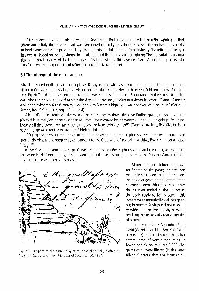
OIL RESEARCH IN ITALY IN "HE SECOND HALF OF THE NINETEENTH CEWTURV
Ribighini mentions his real objective for the first time: to find crude oil from which to refine lighting oil. Both abroad and In Italy, the Italian subsoil was considered rich in hydrocarbons. However, the backwardness of the national extraction system prevented Italy from reaching ¡ts fu11 potentlal in oil industry. The refining industry in Italy was still based on the transformaron coal, peat and llgnite into gas for lighting. The industrial restructura-tion for the production of oil for lighting was in ¡ts ¡nitial stages.This favoured North American importers, who introduced enormous quantities of refined olí into tfie Italian market.
3,1 The at tempt of the entrepreneur
Ribighini decided to dig a tunnel on a plañe slightly leaning wi th respect to the torrent at the foot o f the little hill up on the two sulphur sprlngs, convinced on the existence of a deposit from which bítumen flowed into the river (Fig. 6). This did not happen, but the results were notdisappointing: "Encouraged by these tests (chemical evaluation} I prepared the field to start the digging operations, finding at a depth between 12 and 15 meters a cave approximately 6 to 8 meters wide, and 4 to 6 meters high, with walls soaked with bitumen" (Capellini Archive, Box XIX, folder o, paper 1, page 4).
Ribighini's team contmued the excavation a few metres down the cave finding gravel, topsoil and large pleces of blue marl, which he described as "completely soaked by the waters of the sulphur springs. We do not know yet if they come from the mountain above or from below the soiI" (Capellini Archive, Box XIX, folder o, paper 1, page 4}. After the excavation Ribighini claimed:
"During the rains bitumen flows much more easily through the sulphur sources, in flakes or bubbles as large as cherries, and subsequently converges into the Great Arollo" (Capellini Archive, Box XIX, folder o, paper 1, page 5),
A few days later some harvest pools were built between the sulphur springs and the creek, ascending on decreasing levels (conceptually, it is the same principie used to build the gates o f t he Panama Canal), in order to start draininq as much oil as possible.
Bitumen, being lighter than wa-ter, floated on the pools; the f low was rnanually controlled through the open-ing of water gates at the bottom of the catchment area. With this forced flow, the bitumen settled at the bottom of the pools ready to be collected—this system was theoretically well designed, but in practlce it often did not manage to withstand the impetuosity of water, resulting in the loss of great quantities of bitumen.
In a letter dated December 30th, 1864 (Capellini Archive. Box XIX, folder o, paper 2), Ribighini wrote that after several days of very strong rains, in fewer than six hours about 3,000 kilo-grams of oil were filtered {in this letter Ribighini states that the bitumen fil-
y a *
Figure 6, Diagram of the tunnel dug at the foot of the hill, drafted by Ribighini. Extract taken f rom his letter of December 20, 1864.
2 0 5

FRANCESCO GERALI
tered from the water was collected ¡n twenty botticini, that is barréis. Dividing the quantity of product declared by Ribighini —around 3,000 lcg— by the number of barréis, we obtain a valué, which is approximately 150 Kg a barre!. The valué of the barrel as we understand it today — 4 2 Gallons, that is 159 kg— was established ín an agreement between the main American producers in 1866, and later officialised by the API (American Petroleum Institute) at the beginning of the 1870s. Before 1866 the volume of barréis that arrived from the USA to Europe was 40 Gallons, around 151 kg. This was an ordinary measurement employed for liquids and solids (grain and milled producís). In a study on the history of the Italian petrol industry in the 19th century it is not easy to find quantitative parameters (volumes produced, transponed, commercialized and coincíding units of measurement). This is especially the case in the years 1850 and 1870, that is to say, when there was no real national industry, but ¡ust a multitude of small local companies. The use of these barréis in Tocco da Casauria could be proof of the fact that Italy was adapting its productive structure to compete in the national market using the same Instruments foreign competitors used).
3.2 The role of the geologist
Ribighini acquired the rights o f the Big Arollo perimeter, which the locáis always considered of mlnor importan-ce, and against all expectations, he was obtaining good results. Why was Capellini needed therefore?
The answer can be found in the questions Ribighini posed to him;
Will the phenomenon be isolated, or can ¡t derive into something more than bitumen dragged by the intensity of the rains?; Comparing these events with other cases abroad, are there chances of discov-ering a large deposit? Is it worthwhile to continué the exploration in depth? Are these effusions an indication of a large storage that deserves to be dug further? Do you consider it appropriate to dig wells, or to drill? (Capellini Archive. Box XIX, folder o, paper 1, page 11}.
These questions are indicative of what the olí entrepreneurs, slowly, started to ask to geologists: the drillers questioned geologists on the origin of oil, where it could be accumulated, and which point could be betterto bore. Geology was undoubtedly the first scientific discipline to be involved in the modern oil industry when it started to take its first steps.
All the circumstances described until now led Ribighini to believe in the existence of a large underground deposit (petroleum was present in the subsoil In the form of micro drops trapped In the porosity of the deposit rocks, where it settles after migration from the mother rocks; in the scientific literature of the 1860s this con-cept of a deposit had not yet been made clear. Information about the soil was collected analyzing the fragments of the soil excavated manually —collected with buckets— or mechanically-collected with the appropriate curettes-; this has permited identifícation of the nature of the layers, but the real structure of a deposit was still not clear, which was generally interpreted as a large reservoir of líquid oil; Levorsen, 1954; Stoppani 1871). He had the necessary means to initiate perforation, but to ensure success he reatized it was essential to have a scientific evaluation from an expert in the field. After an interview with Capellini in Bologna iri January 16th, 1865 (Capellini Archive. Box XIX, folder o, paper 3), Ribighini informed him that before making a decisión on his involvement he wished to discuss this matter with his business associates, reassuring him that he would be in touch in a few days (Capellini probably asked for higher compensation for his technical advlce than that foreseen by Ribighini, and could not immediateiy agree on what Capellini charged). This did not happen and then followed a long silence between them that lasted until the end o f t he year.
2 0 6

011 RESEARCH IN ITAIY IN THE SECOND HALf OF THE N I N E I t E N T H CEWTURY
3.3 Antonio Stoppani
In September of 1864 laschl and Trovati had called the Abbot Antonio Stoppani (Geologist and naturalist, Lecco 1824-Milan 1891. During his surveys in locco da Casau-ria he worked together with the geologist Beggiato, from Vicenza, and the engineer Pisani, from Venice; Stoppani, 1866a) (Fig. 7), for a geological consultation. He suggested excavating manually a survey well a few metres away from the spring, but this did not have much success. Stoppani described his experience in Tocco da Casauria in two arti-des (Stoppani, 1866a,b) published in 1866 in the journal "II Politécnico". He wrote that he remained in contact with Laschi and Trovati, and Ribighini, throughout 1865, adding that he received continuous updates on developments at Grande Arollo from the latter (the exchange of informa-tion between Stoppani and Ribighini is a controversialfact; as mentioned before, when Ribighini wrote to Capellini, F i9u r e 7 ' A n t o n i o S t ( W a n i ( L e c c D 11B24 M l l a n 0 1 8 9 1 ) ' he criticised the work carried out by Laschi and Trovati's geologists due to the lack of results and their little experience; Stoppani was among these; perhaps Ribighini, in his letters to Capellini, was mixing praise of his profession with criticism of other colleagues to win his favour), Stoppani reports that Ribighini intended to evade the unpredictability of the weather. At the end of September of 1865 Ribighini decided to introduce water inside the cave artificiaIJy, digging a channel to modify the course of the water of the creek. This attempt worked appropriately, allowing Ribighini to get the swelling of the sulphur springs regardless of rain. At the end of November he managed to get a quantity of bitumen evaluated between seventy and eighty thousand kilograms in only four days by aiternating the flow of water.
On December 14th, 1865 (Capellini Archive, Box XIX, foldero, paper 4), Ribighini writes to Capellini explain-ing his silence due to his father and brother-in-law's death —his business associates. He invited Capellini again to Tocco da Casauria, mentioning that his new firms have decided to accept his requirements.
A few weeks before, on the other side of the branch of the Arollo, Laschi and Trovati found the first encour-aging signs on the presence of oil in their area at 32 metres of depth, after a series of disappointing results. They decided to abandon manual excavation and turned to mechanical perforation. They contacted the French society Degousée & Laurent, one of the leaders In the production of systems for the search of water and oil. Ribighini did not want to lose ground as far as his competitors were concerned.
4. THE GEOLOGICAL ANALYSIS OF GIOVANNI CAPELLINI
Capellini's expertise was needed to start perforations in depth as soon as possibie. Capellini arrived at Tocco da Casauria on January 7th, 1866, and completed his report on January 18th. In
the following months, he published his observations in the technical report entitled " Petrolio di Tocco e Bitumi di Letto Manopello" (Capellini, 1866) (Fig. 8).
With his geological evaluation, he managed to clarify many aspects of the geological structure of the area. As far as the stratigraphy of the land is concerned, he says:
2 0 7

F R A I L E S C O GERALI
The creek fol lows the trend of a fault line through which are in contact the nummulitic limestone wi th Miocene soil: the latter is covered by a tufa deposit which I consider to be post-Tertiary, mainly composed of chalk, chalky marl and scaly clay. In this " incoherent" material the presence of bitumen is concentrated (Capellini, 1866).
Then he focuses on the underground f low of water, hypothesizing the existence of a second underground cave which was much deeper than the first one:
At the moment in which we introduce the water, it takes 4 to 6 hours before going out via the sulphur spring: it is impossible for the current to fol low a linear path.
Therefore, he argües:
there must be a large underground cavern situated circa 80 metres down the level of the spring, which reproduces the conditions occurring in the trap that bears the ñame of Tan ta lus Cup, which must be the cause of these intermittent oil effusions. This huge cave, I suppose, communicates with cracks and crevices where a certain amount of thick oil is accumulated. So, the water reaches the cave passing through the hole opened by Mr. Ribighini, then washes its walls and begins to accu-mulate until, having reached a certain level, the siphon starts to operate. Oil mixed wi th water starts to run into a tunnel that leads it to the sources and then from these flows into the harvest pools. (Capellini, 1866)
Once his analysis was completed, Capellini answered Rlbighini's main questions:
All this can reveal the existence of an oil depot in the subsoil of Tocco that must be huge (Capellini, 1866).
Capellini argued that the minerals found until then proved the existence of deposits situated at a greater depth, from which oil ascended naturally Into the surface strata filtering through the poroslty of the rocks. The oil starts to oxidize when in contact wi th oxygen, turning into bitumen. It therefore reaches the surface through the f low of water, naturally or forced. Once the phenomenon is explained, he adds that the main deposits could be reached by perforat-ing at sufficient depth (Capellini does not explain what he means by sufficient depth. However, in another passage he refers to his work carried out in Romania, where he argües that in order to obtain satisfying results it was necessary to dig over thirty metres in depth; Gerali, 2010).
Referring to a note (Capellini Archive, Box XIX, folder o, paper 5) received from a foreman, Capellini wrote in his
P « I I , . ,
f ' E T H O U O D I T O C T O * f
I H T 1 M I D I L U T O I I O N ' O P B t U )
R E L A Z I O N E
•ir0Dl*«ruU di Boloffu
• i i n u w
f igure 8. The report published by Capellini in 1866.
2 0 8
011 RESEARCH IN ITALY IN THE SECOND HALF OF THE NINETEENTH CENTURY
report that between February and December 1865, approximately 120,000 kilograms of oil were filtered and stored, and ¡n the same period about 100,000 kilograms were lost since the harvest basins were not com-pleted. He emphasises that this is a huge amount, whereas this mineral proceeds through rudimentary filtering, but at the same time he claims:
The oil collected until last year is a small fract/on of what is possible to get when the major reservoirs will be reached by exploring the soil in depth (Capellini, 1866).
Capellini completed his work by indicating to Leopoldo Ferretti, mine engineer director of the operations, the areas where to dig two exploratory wells in order to lócate the reservoir.
5. AFTER THE EXPLOITATION
Ribighini started to dig different wells manually (with this method wells were dug at variable depths — 3 0 to 60 metres—, whose average dlameter was 1.20 to 1.50 metres. During digging, the walls were covered in masonry to prevent collapse) and mechanically (with the rope system called the "Pennsylvanian" system), soon obtaining a regular production. Between 1865 and 1866 the mineral extracted in Tocco da Casauria was transponed to a small laboratory in Porto Recanati (Province of Macerata, Marche región), where oil for lighting was refined, which he called Toccolina. In a letter addressed to Capellini on December 9th, 1866 (Biblioteca Archiginnasio, Fondo "Giovanni Capellini", box CXVlll, folder 4), he wrote that he was making great profit from the sales of this product. He had bought a former sugar factory in Grottammare (Province of Ascoli Piceno, Marche región), where he intended to establish a larger refinery (this project was concluded in 1867: as well as oil for lamps, he starts producing soaps, sulphur, asphalt, pitch for the naval industry and varnish; Ribighini, 1867). He had gradually reached his objective: after having reached an important position within the local market, he was expanding his business to the neighbouring regions. His product was also publicized in the north of Italy and he had the intention of sending some samples of his oil to the Universal Exhibition of 1867, in Paris. That same year Ribighini went into business with Leopoldo Ferretti, director of the site in Tocco da Casauria, founding the Anonymous Society of Abruzzo for the mining operations of the Majella (the personal archive of Giovanni Capellini does not make any reference concerning this mining society; perhaps he was not contacted -or did not want to be involved- with new geoiogicai surveys associated wi th petroleum deposits).
6. CONCLUSIONS
A raw material which is not associated to a transformaron process has not much interest to society. Oil was (alimost) inert for centuries, but in a few years some businessmen decided to invest a Iarge amount of money. Why?
During the first sixty years of the 19th century, when chemistry revealed the real potential of rock oil, oil became the protagonist of a little mining revolution, which aróse from human, economic, technical and scien-tific investments.
Some entrepreneurs like Ribighini began to hire earth scientists to optimize research and therefore speed up productive processes, by explicitly recognising the valué of geoiogicai research applied to oil production (however, many years had to pass before science and oil production joined forces. Companies such as Blumer
2 0 9

FRANCESCO GERALI
& Jenny, and Laschi and Trovati had the organisation and economic strength which allowed them to invest in "science", Iti Italy, the majority of companies that invested in oii research were small and had little capital at their disposal; Squarzlna, 1958),
In the first sixty years of the nineteenth century, olí was a topic often neglected in Geology textbooks. How-ever, increasing research carried out on this mineral reached such a significance that, In the following years, a new branch deaiing with this fleld was establlshed: Petroleum Geology.
REFERENCES
Archivio Storico dell 'Accademia Lunigianese di Scienze "Giovanni Capel l im", Box XIX, Folder O, papers 1-6; Folder N, paper 1.
Ariosto, F. 1690. De oleo Montis Zibinii seu petrolio agri mutinensis. Libellus e Manuscriptis membranis editus ab Oligerus Jacobaeo. Hafniae, Llteris Reg. Maj .& Univ. Typogr Joh. Phil. Bockenhoffer, Coopenhagen, 79 pp.
Barnard, H. (ed.) 1869. The American Journal of Education. Office of American Journal of Education, Hartford, 824 pp. Biblioteca Archiginnasio, Fondo "Giovanni Capel l lní" . Box CXVIII, folder 4, papers 1-3. Bondaroy Fougeroux, A. D. de 1770. Second Mémolre sur le Pétrole et sur des vapeurs ¡nflammables, connues das quelques
partles de l ' ltalie. Histoire de l'Académie Royale des Sciences París, 91, 23-39 . Bossi, L., 1817. Spíegazíone di alcuní vocabolí geologici, lítologici, mineralogía, per ordíne d'alfabeto. Tipografía Sonzogno
e comp., Milano, 6 4 pp. Capellim, G. 1864, Report on the Petroleum Dístricts in Wallachia, belonging to the Wallachian Petroleum Company.
Limited. Ploesti 15th Oct. 1864. Internal company report, 8 pp. Capellim, G. 1866, Petrolio diTocco e Bitumi di Letto Manopel lo. Regia Accademia delle Scienze diTorino, Serie /III, 13 pp. Capellim, G. 1867. Ricordi di un viaggio scientifico nell'America settentrionaie nel MDCCCLX/ll. Tipografía GiuseppeVitati,
Bologna, 279 pp. Capellini, G. 1868. Giacimenti petrol i fer i di Valacchia e loro rapport i coi terreni terziari del l ' l tal ia centrale. Memorie deíía
Regia Accademia delle Scienze dell'istituto di Bologna Serie III, VII, 5-41. Capellini, G. 1870. Compendio di geología per uso degli aliievi della Regia Universitá di Bologna. Parte la. Tipografía
Galeati, Bologna, 119 pp. Capellini, G. 1910. Professore a Bologna. Ricordí autobiografía, 1861-1871. Tipografía Galeati, mola, 203 pp Capellini, G. 1914. Ricordí 1860-1888, vol. i. Nicoía Zanichelli Editare, Bologna, 242 pp. Degousée, J. M. A. and Laurent, C. A. 1861. Guide du sondeur; ou, Traite théoriques et pratíque des sondages, Volume I.
XI! edítion, Garnier Fréres, París, 491 pp. Department of State of USA, 1868. List of the diplomatic and consular officers of the United States. Government Printing
Office. Washington, 213 pp. Fairman, J. 1868. A Treatise on the petroleum zones of Italy. E.& F. N. Spon, London, 75 pp. Forbes, R. J. 1958. Studies in early petroleum history. Brill, Leiden, 199 pp. Gerali, F. 2010. Geology and oil exploration; the studies of Giovanni Capellini ín Romanía. Oil Industry History Journal,
10(1), 121-131. Henry, T. J. 1873. The earlier and later history of petroleum. Jas. B. Rodgers & Co. printers, Phíladelphia, 198 pp. Jervis, G. 1873. / tesón sotterrane/ dell'ltalia, parte II. Loescher, Torino, 624 pp. Levorsen, A.l . 1954. Geology of Petroleum. Freeman and Company, San Francisco, 239 pp. Maginl , M. 1977. L'ltalía e il petrol io tra storia e cronología. Mondator i , Vicenza, 325 pp. Markbreiter, E. 1928. Giovanni Capellini e il suo Carteggio. In LARCHIGINNASIO. Bullettino della biblioteca comnale di.
2 1 0

OIL RESEARCH IN ITALY N IHL SECOND HAI F O F T H f NINETEENTH CENTLRY
0o/ogri3".Tecnical report, YearXXII, issue 5, September. Bologna, 245-267. Markbreiter, E. 1928. Giovanni Capellini e íl suo Carteggio. L'Aechlginnasio. Bullettino della biblioteca comunale di
Bologna". Technicalreport, YearXXII, issue 6,29-74. Marrara, H.R. 1942. Unpubl ished American documents on the naval batt le of Lissa (1866). Journal of Modern History, 14
(3), 342-356. Massimi, G. 2002. L'Abruzzo, Tocco da Casauria e il Bel Paese. Itinerari, Lanciano, 224 pp. Montagnani, P. 1955. IIpetrolio italiano. Edizionl cultura sociale, Milano, 194 pp. Novelll, L. and Sella, M. 2009, II petrolio: una storia antica. Silvana Editoriale, Cinisello Balsamo, 501 pp. Ribighini, C. and Ferretti, L. 1867. Memoria diretta al comitato promotore di una societa anónima abruzzese per l'esercizio
delle miniere della Majella. Internal company report, 1 - 1 1 . Spadonl, P. 1802. Osservazioni mineralovulcaniche fatte in un viaggio per Tantico Lazio. Presso Bartolomeo Capitani,
Macerata, 164 pp. Sdcli, A. 1972. L'attivitá estrattiva e le risorse minerarie della regione Emilia Romagna. Poligrafico Art iol i , Modena, 332 pp, Squarzina, F. 1958. Le ricercbe del petrolio in Italia, Cenni storici dal 1860 e cronache deil'ultimo decennio. Jandi Sapi,
Roma, 270 pp. Stoppani, A. 1866a. I petroli In Italia, I. II Politécnico, serie ÍV\, 77-93. Stoppani, A. 1866b. I petrol i in Italia, II. II Politécnico, serie IV, II, 219-230. Stoppani, A. 1871. Corso di Geología, vol. I. G. Bernardoni e G. Brigola Editori, Mi lano, 504 pp. Stoppani, A. 1873. Corso di Geología, vol. III. G. Bernardoni e G. Brigola Editori, Milano, 704 pp. Trapani, F. 2003. L'Oleum Petronicum, un antico r imedio galénico delle falde settentr ional i della Majel la. Annuario del Club
Alpino Italiano - Sezione di Pescara. CAI, Pescara, 61-76 .
2 1 1