La Geoquímica en la Evaluación de Recursos de Shale-oil y ... · Héctor J. Villar...
20
Héctor J. Villar [email protected] La Geoquímica en la Evaluación de Recursos de Shale-oil y Shale-gas SPE de Argentina; 30 de abril de 2013
Transcript of La Geoquímica en la Evaluación de Recursos de Shale-oil y ... · Héctor J. Villar...
Héctor J. Villar [email protected]
La Geoquímica en la Evaluación de Recursos
de Shale-oil y Shale-gas
SPE de Argentina; 30 de abril de 2013
La Geoquímica en la Evaluación de Recursos de Shale-oil y Shale-gas
Los recursos potenciales de Shale en Argentina
Argentina Basins
Geological and Geochemical Keys of the
Potential Shale Resources
AAPG GTW June 26-28, 2011 – Buenos Aires, ArgentinaUnconventional Resources: Basics, Challenges and Opportunities for New Frontier Plays
Leonardo Legarreta (1) and Héctor J. Villar (2)
(1) (2)PatagoniaExploración s.a.
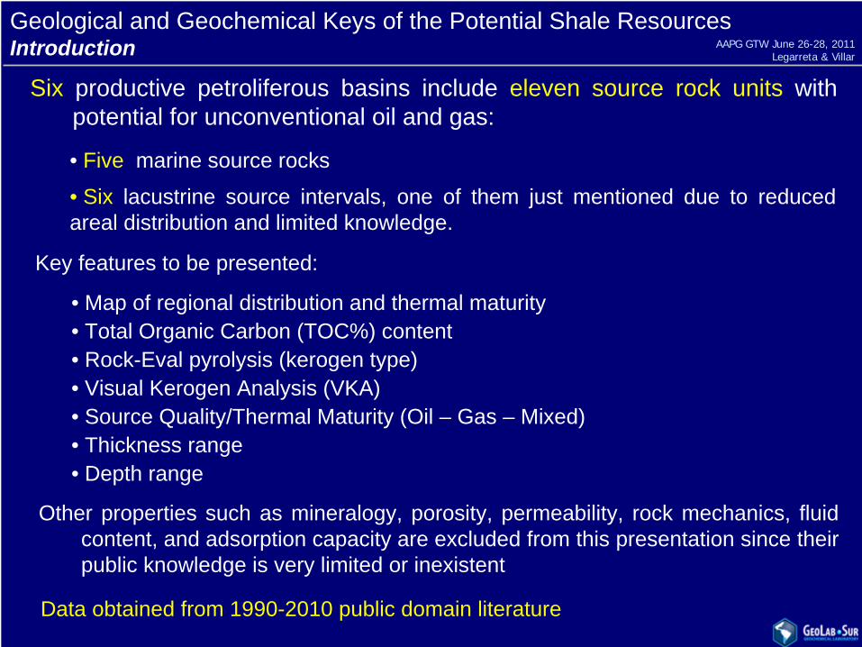
Geological and Geochemical Keys of the Potential Shale ResourcesIntroduction
Six productive petroliferous basins include eleven source rock units with potential for unconventional oil and gas:
• Five marine source rocks
• Six lacustrine source intervals, one of them just mentioned due to reduced areal distribution and limited knowledge.
Other properties such as mineralogy, porosity, permeability, rock mechanics, fluid content, and adsorption capacity are excluded from this presentation since their public knowledge is very limited or inexistent
• Map of regional distribution and thermal maturity• Total Organic Carbon (TOC%) content• Rock-Eval pyrolysis (kerogen type)• Visual Kerogen Analysis (VKA)• Source Quality/Thermal Maturity (Oil – Gas – Mixed)• Thickness range• Depth range
Key features to be presented:
Data obtained from 1990-2010 public domain literature
AAPG GTW June 26-28, 2011Legarreta & Villar
PALEOZOIC CUYO NEUQUENPETROLIFEROUS BASINS OF ARGENTINA
AUSTRAL CRETACEOUSSAN JORGE
2.6
29
25
8
8
8
1
7
9
1
(1) (2
530
520
510
500
490
480
470
460
450
440
430
420
410
400
390
380
370
360
350
340
330
320
310
300
290
280
270
260
250
240
230
220
210
200
190
180
170
160
150
140
130
120
110
100
90
80
70
60
6
4
)
Global Eustatic Curve and Contribution of the Source Rocks to the World (1)and Argentina Reserves (2)
TIME
Tertiary
CR
ETA
CEO
US
EAR
LYLA
TE
JUR
ASS
IC
EAR
LYLA
TEM
IDD
LELA
TEE
M
TRIA
SSIC
PER
MIA
NL
EAR
LY
CA
RB
ON
IFER
OU
S
EAR
LYL
MID
DLE
DEV
ON
IAN
SILU
RIA
NO
RD
OVI
CIA
NC
AMB
RIA
N
ELA
TENEOCOMIANO
KEROGENTYPE: II/III
TOC:0.5-3%
SPI: 4 (?)
YACORAITE
0.5-6%
SPI:1
TOC:II(III)TYPE:
KEROGENL. Cretaceous
D-129
1-3%
SPI:10(?)
TOC:TYPE: I/II (III)
KEROGENE. Cretaceous
LOS MONOS
: II/IIIto III/IV
0.5-1%SPI:1-3
TOC:
TYPE:KEROGEN
L. Devonian
P. AIKE
II/III
0.5-2 %
SPI:1-2
TOC:TYPE:KEROGEN
E. Cretaceous
S. TOBIFERA
SPI:?
TOC:TYPE: I to IIIKEROGEN
M - L. Jurassic
1-3 (10) %
AGRIO
II to II/III
2-5%SPI:4-12
TOC:TYPE:
KEROGENE. Cretaceous
V . MUERTA
I-II/IIS
3-8 %SPI:5-20
TOC:TYPE:KEROGENL. Jurassic
LOS MOLLES
II/III
1-5%SPI:6 (?)
TOC:
TYPE:KEROGENE. Jurassic
CACHEUTA
I
3-10%SPI:8-10
TOC:TYPE:KEROGEN
M. Triassic
BOLIVIA
BRASIL
URUGUAY
PARAGUAYCHILE
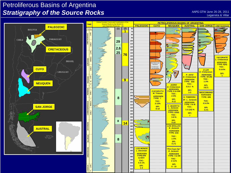
Petroliferous Basins of ArgentinaStratigraphy of the Source Rocks
?
CRETACEOUS
?
( )
PALEOZOIC
Red Beds andvolcanics.
CondensedaccumulationCUYO
? ?
NEUQUEN
AUSTRAL
SAN JORGE
“Pre-Cuyo Gp”
2-11%
SPI:
TOC:TYPE: I to I/IIIKEROGEN
E. Jurassic
5 - 10
AAPG GTW June 26-28, 2011Legarreta & Villar
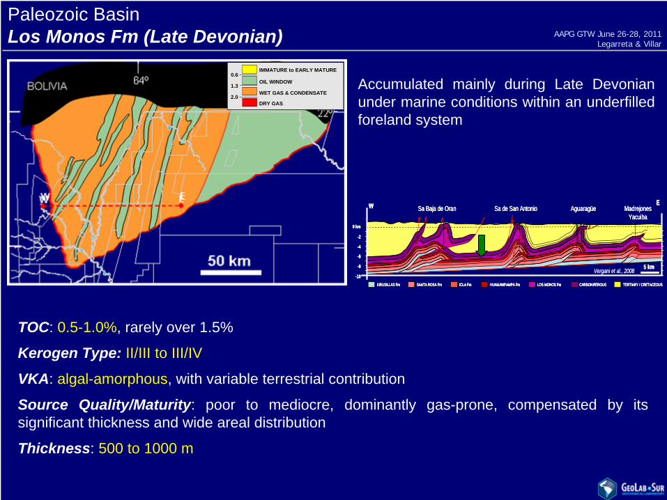
Paleozoic BasinLos Monos Fm (Late Devonian)
Accumulated mainly during Late Devonian under marine conditions within an underfilled foreland system
2.0
1.3
0.6IMMATURE to EARLY MATURE
OIL WINDOW
WET GAS & CONDENSATE
DRY GAS2.0
1.3
0.6IMMATURE to EARLY MATURE
OIL WINDOW
WET GAS & CONDENSATE
DRY GAS
TOC: 0.5-1.0%, rarely over 1.5%
Kerogen Type: II/III to III/IV
VKA: algal-amorphous, with variable terrestrial contribution
Source Quality/Maturity: poor to mediocre, dominantly gas-prone, compensated by its significant thickness and wide areal distribution
Thickness: 500 to 1000 m
-2
-4
-6
-8
0 km
-10
Aguaragüe MadrejonesYacuiba
Sa Baja de Oran Sa de San Antonio
CARBONIFEROUS TERTIARY / CRETACEOUSLOS MONOS FmHUAMAMPAMPA FmICLA FmSANTA ROSA FmKIRUSILLAS Fm
5 km
W E
Vergani et al., 2008
-2
-4
-6
-8
0 km
-10
Aguaragüe MadrejonesYacuiba
Sa Baja de Oran Sa de San Antonio
CARBONIFEROUS TERTIARY / CRETACEOUSLOS MONOS FmHUAMAMPAMPA FmICLA FmSANTA ROSA FmKIRUSILLAS Fm
5 km
W E
-2
-4
-6
-8
0 km
-10
Aguaragüe MadrejonesYacuiba
Sa Baja de Oran Sa de San Antonio
CARBONIFEROUS TERTIARY / CRETACEOUSLOS MONOS FmHUAMAMPAMPA FmICLA FmSANTA ROSA FmKIRUSILLAS Fm CARBONIFEROUS TERTIARY / CRETACEOUSLOS MONOS FmHUAMAMPAMPA FmICLA FmSANTA ROSA FmKIRUSILLAS Fm
5 km
W E
Vergani et al., 2008
AAPG GTW June 26-28, 2011Legarreta & Villar
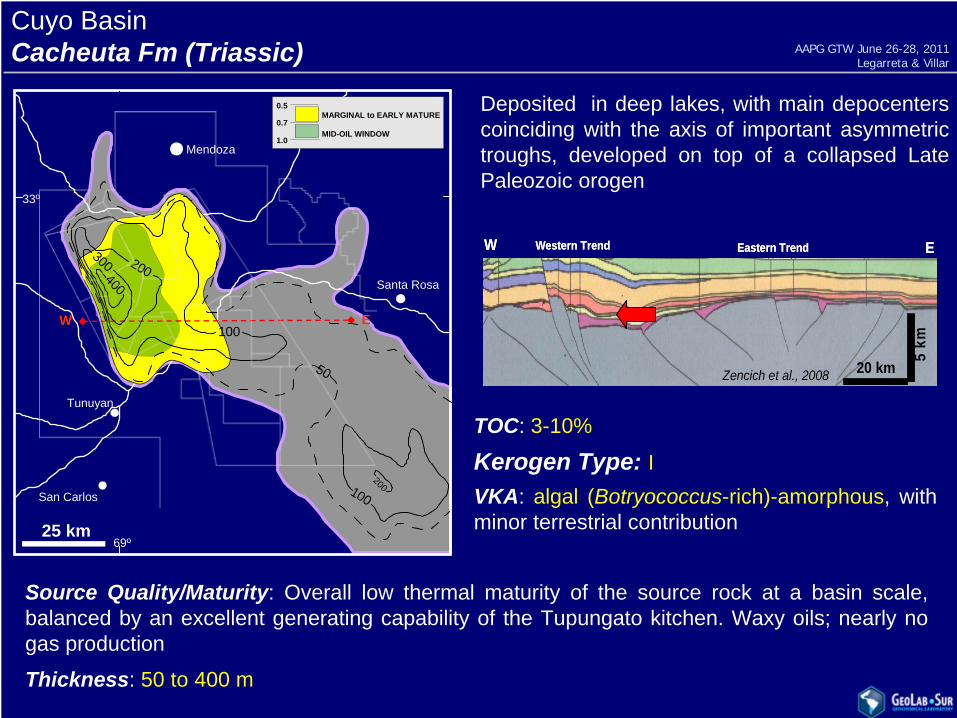
Cuyo BasinCacheuta Fm (Triassic)
Deposited in deep lakes, with main depocenters coinciding with the axis of important asymmetric troughs, developed on top of a collapsed Late Paleozoic orogen
TOC: 3-10%
Kerogen Type: IVKA: algal (Botryococcus-rich)-amorphous, with minor terrestrial contribution
Source Quality/Maturity: Overall low thermal maturity of the source rock at a basin scale, balanced by an excellent generating capability of the Tupungato kitchen. Waxy oils; nearly no gas production
Thickness: 50 to 400 m
69º
33º
Mendoza
Santa Rosa
Tunuyan
San Carlos
25 km
100
200300
400
100200
50
1.0
MARGINAL to EARLY MATURE
MID-OIL WINDOW0.7
0.5
W E
Western Trend Eastern TrendW E
5 km
Zencich et al., 2008 20 km
Western Trend Eastern TrendW E
5 km
Zencich et al., 2008 20 km
AAPG GTW June 26-28, 2011Legarreta & Villar
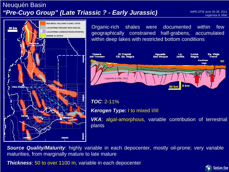
Neuquén Basin“Pre-Cuyo Group” (Late Triassic ? - Early Jurassic)
SEKauffmanHigh
LaJarilla
LomaNegra
Ea. ViejaTrend
AguadaSan Roque
El TrapialCh. Sa. Negra
Yeseradel Tromen
NW
30 km 5 km
SEKauffmanHigh
LaJarilla
LomaNegra
Ea. ViejaTrend
AguadaSan Roque
El TrapialCh. Sa. Negra
Yeseradel Tromen
KauffmanHigh
LaJarilla
LomaNegra
Ea. ViejaTrend
AguadaSan Roque
El TrapialCh. Sa. Negra
Yeseradel Tromen
LaJarilla
LomaNegra
Ea. ViejaTrend
AguadaSan Roque
El TrapialCh. Sa. Negra
Yeseradel Tromen
NW
30 km 5 km30 km 5 km
Organic-rich shales were documented within few geographically constrained half-grabens, accumulated within deep lakes with restricted bottom conditions
26000002400000 26000002400000
5800
000
5600
000
6000
000
5800
000
5600
000
6000
000
50 km
NeuquenHuinculZapala
Chos Malal
Malargue
50 km50 km
NeuquenHuinculZapala
Chos Malal
Malargue
26000002400000 26000002400000
5800
000
5600
000
6000
000
5800
000
5600
000
6000
000
50 km
NeuquenHuinculZapala
Chos Malal
Malargue
50 km50 km
NeuquenHuinculZapala
Chos Malal
Malargue
26000002400000 26000002400000
5800
000
5600
000
6000
000
5800
000
5600
000
6000
000
26000002400000 26000002400000 26000002400000 26000002400000
5800
000
5600
000
6000
000
5800
000
5600
000
6000
000
5800
000
5600
000
6000
000
5800
000
5600
000
6000
000
50 km50 km
NeuquenHuinculZapala
Chos Malal
Malargue
50 km50 km
NeuquenHuinculZapala
Chos Malal
Malargue
RED BEDS, VOLCANIC FLOWS, TUFFS
LACUSTRINE ORGANIC-RICH SHALES
LACUSTRINE CARBONATES/EVAPORITES
MARINE CLASTICS
RED BEDS, VOLCANIC FLOWS, TUFFS
LACUSTRINE ORGANIC-RICH SHALES
LACUSTRINE CARBONATES/EVAPORITES
MARINE CLASTICS
TOC: 2-11%
Kerogen Type: I to mixed I/III
VKA: algal-amorphous, variable contribution of terrestrial plants
Source Quality/Maturity: highly variable in each depocenter, mostly oil-prone; very variable maturities, from marginally mature to late mature
Thickness: 50 to over 1100 m, variable in each depocenter
Legarreta & Villar, 2011
AAPG GTW June 26-28, 2011Legarreta & Villar
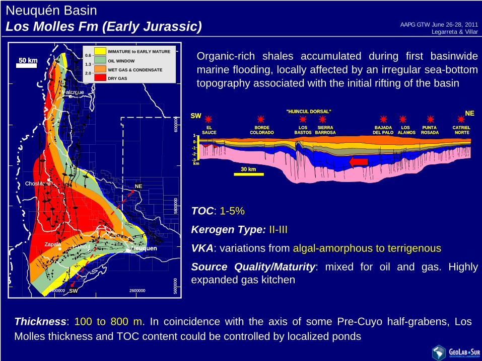
Neuquén BasinLos Molles Fm (Early Jurassic)
ELSAUCE
BORDECOLORADO
LOSBASTOS
SIERRABARROSA
BAJADADEL PALO
LOSALAMOS
PUNTAROSADA
CATRIELNORTE
"HUINCUL DORSAL"
30 km
SW NE
-1-2-3
10
km
ELSAUCE
BORDECOLORADO
LOSBASTOS
SIERRABARROSA
BAJADADEL PALO
LOSALAMOS
PUNTAROSADA
CATRIELNORTE
"HUINCUL DORSAL"
30 km
SW NE
-1-2-3
10
km
Organic-rich shales accumulated during first basinwide marine flooding, locally affected by an irregular sea-bottom topography associated with the initial rifting of the basin
TOC: 1-5%
Kerogen Type: II-IIIVKA: variations from algal-amorphous to terrigenous
Source Quality/Maturity: mixed for oil and gas. Highly expanded gas kitchen
Thickness: 100 to 800 m. In coincidence with the axis of some Pre-Cuyo half-grabens, Los Molles thickness and TOC content could be controlled by localized ponds
26000002400000 26000002400000
5800
000
5600
000
6000
000
5800
000
5600
000
6000
000
50 km
NeuquenHuinculZapala
ChosMalal
Malargue
50 km50 km
NeuquenHuinculZapala
ChosMalal
Malargue
2.0
1.3
0.6IMMATURE to EARLY MATURE
OIL WINDOW
WET GAS & CONDENSATE
DRY GAS2.0
1.3
0.6IMMATURE to EARLY MATURE
OIL WINDOW
WET GAS & CONDENSATE
DRY GAS
NE
SW
AAPG GTW June 26-28, 2011Legarreta & Villar
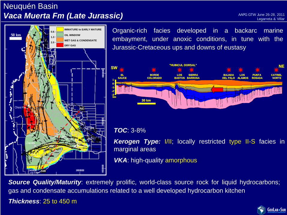
Neuquén BasinVaca Muerta Fm (Late Jurassic)
Organic-rich facies developed in a backarc marine embayment, under anoxic conditions, in tune with the Jurassic-Cretaceous ups and downs of eustasy
ELSAUCE
BORDECOLORADO
LOSBASTOS
SIERRABARROSA
BAJADADEL PALO
LOSALAMOS
PUNTAROSADA
CATRIELNORTE
"HUINCUL DORSAL"
30 km
SW NE
-1-2-3
10
km
ELSAUCE
BORDECOLORADO
LOSBASTOS
SIERRABARROSA
BAJADADEL PALO
LOSALAMOS
PUNTAROSADA
CATRIELNORTE
"HUINCUL DORSAL"
30 km
SW NE
-1-2-3
10
km
TOC: 3-8%
Kerogen Type: I/II; locally restricted type II-S facies in marginal areas
VKA: high-quality amorphous
Source Quality/Maturity: extremely prolific, world-class source rock for liquid hydrocarbons; gas and condensate accumulations related to a well developed hydrocarbon kitchen
Thickness: 25 to 450 m
2.0
1.3
0.6IMMATURE to EARLY MATURE
OIL WINDOW
WET GAS & CONDENSATE
DRY GAS2.0
1.3
0.6IMMATURE to EARLY MATURE
OIL WINDOW
WET GAS & CONDENSATE
DRY GAS
NE
SW
AAPG GTW June 26-28, 2011Legarreta & Villar
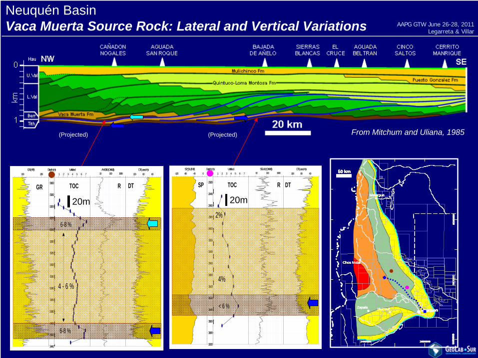
Neuquén BasinVaca Muerta Source Rock: Lateral and Vertical Variations
From Mitchum and Uliana, 1985
26000002400000 26000002400000
5800
000
5600
000
6000
000
5800
000
5600
000
6000
000
50 km
NeuquenHuinculZapala
Chos Malal
Malargue
50 km50 km
NeuquenHuinculZapala
Chos Malal
Malargue
26000002400000 26000002400000
5800
000
5600
000
6000
000
5800
000
5600
000
6000
000
50 km
NeuquenHuinculZapala
Chos Malal
Malargue
50 km50 km
NeuquenHuinculZapala
Chos Malal
Malargue
26000002400000 26000002400000
5800
000
5600
000
6000
000
5800
000
5600
000
6000
000
26000002400000 26000002400000 26000002400000 26000002400000
5800
000
5600
000
6000
000
5800
000
5600
000
6000
000
5800
000
5600
000
6000
000
5800
000
5600
000
6000
000
50 km50 km
NeuquenHuinculZapala
Chos Malal
Malargue
50 km50 km
NeuquenHuinculZapala
Chos Malal
Malargue
(Projected)
100 200 GR (API)
3160
3180
3200
3220
3240
3260
3280
3300
3320
3340
3360
3380
3400
3420
3440
Depth (m)1 2 3 4 5 6 7
Untitled10 100 1000 AHO90 (OHMS)
6080100 DT (usec/m)
00000000000000
GR R DTTOC
6-8 %
6-8 %
4 - 6 %
100 200 GR (API)
3160
3180
3200
3220
3240
3260
3280
3300
3320
3340
3360
3380
3400
3420
3440
Depth (m)1 2 3 4 5 6 7
Untitled10 100 1000 AHO90 (OHMS)
6080100 DT (usec/m)
00000000000000
GR R DTTOC
100 200 GR (API)
3160
3180
3200
3220
3240
3260
3280
3300
3320
3340
3360
3380
3400
3420
3440
Depth (m)1 2 3 4 5 6 7
Untitled10 100 1000 AHO90 (OHMS)
6080100 DT (usec/m)
00000000000000
GR R DTTOC
6-8 %
6-8 %
4 - 6 %
20m
(Projected)
-120 -80 -40 0 SP_BU (MV)
2920
2940
2960
2980
3000
3020
3040
3060
3080
3100
3120
3140
3160
3180
3200
Depth (m)1 2 3 4 5 6 7
Untitled10 100 1000
SFLA2 (OHMS) 6080100
DT (usec/m)
00
00
00
0
00
00
0
2%
< 6 %
4%
SP R DTTOC
-120 -80 -40 0 SP_BU (MV)
2920
2940
2960
2980
3000
3020
3040
3060
3080
3100
3120
3140
3160
3180
3200
Depth (m)1 2 3 4 5 6 7
Untitled10 100 1000
SFLA2 (OHMS) 6080100
DT (usec/m)
00
00
00
0
00
00
0
2%
< 6 %
4%
SP R DTTOC
20m
AAPG GTW June 26-28, 2011Legarreta & Villar
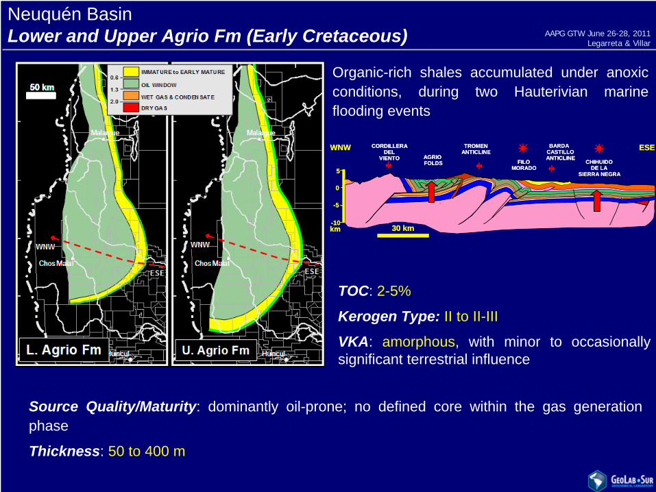
Neuquén BasinLower and Upper Agrio Fm (Early Cretaceous)
CHIHUIDODE LA
SIERRA NEGRA
FILOMORADO
AGRIOFOLDS
30 km
5
0
-5
-10km
WNW ESETROMENANTICLINE
CORDILLERADEL
VIENTO
BARDACASTILLOANTICLINE
CHIHUIDODE LA
SIERRA NEGRA
FILOMORADO
AGRIOFOLDS
30 km
5
0
-5
-10km
WNW ESETROMENANTICLINE
CORDILLERADEL
VIENTO
BARDACASTILLOANTICLINE
Organic-rich shales accumulated under anoxic conditions, during two Hauterivian marine flooding events
TOC: 2-5%
Kerogen Type: II to II-III
VKA: amorphous, with minor to occasionally significant terrestrial influence
Source Quality/Maturity: dominantly oil-prone; no defined core within the gas generation phase
Thickness: 50 to 400 m
AAPG GTW June 26-28, 2011Legarreta & Villar
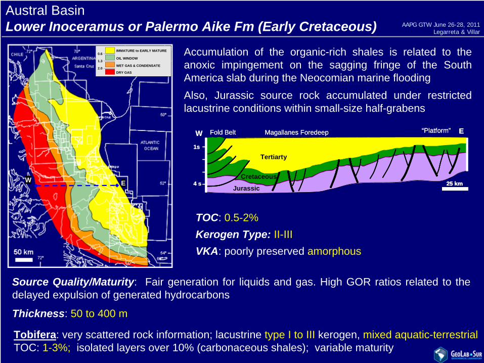
Austral BasinLower Inoceramus or Palermo Aike Fm (Early Cretaceous)
Accumulation of the organic-rich shales is related to the anoxic impingement on the sagging fringe of the South America slab during the Neocomian marine floodingAlso, Jurassic source rock accumulated under restricted lacustrine conditions within small-size half-grabens
25 km
1s
4 s
Magallanes Foredeep “Platform”Fold BeltW E
Tertiarty
Cretaceous
Jurassic25 km25 km
1s
4 s
Magallanes Foredeep “Platform”Fold BeltW E
Tertiarty
Cretaceous
Jurassic
Source Quality/Maturity: Fair generation for liquids and gas. High GOR ratios related to the delayed expulsion of generated hydrocarbons
Thickness: 50 to 400 m
TOC: 0.5-2%Kerogen Type: II-IIIVKA: poorly preserved amorphous
Tobifera: very scattered rock information; lacustrine type I to III kerogen, mixed aquatic-terrestrial TOC: 1-3%; isolated layers over 10% (carbonaceous shales); variable maturity
2.0
1.3
0.6IMMATURE to EARLY MATURE
OIL WINDOW
WET GAS & CONDENSATE
DRY GAS2.0
1.3
0.6IMMATURE to EARLY MATURE
OIL WINDOW
WET GAS & CONDENSATE
DRY GAS
W E
AAPG GTW June 26-28, 2011Legarreta & Villar
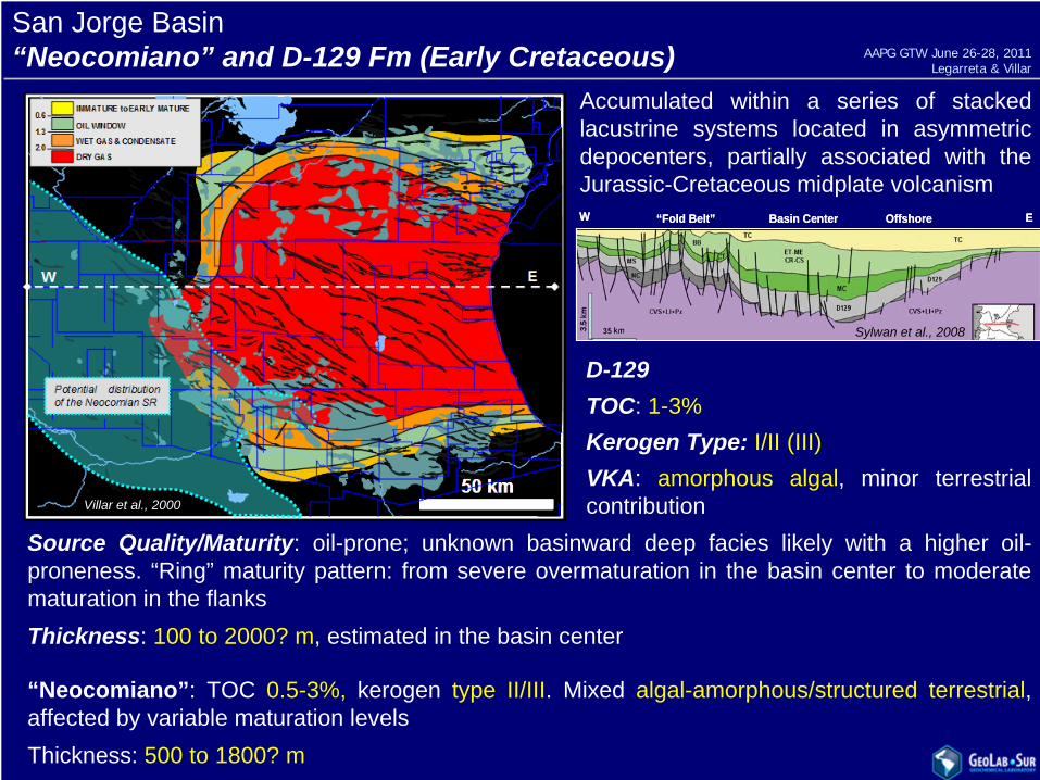
San Jorge Basin“Neocomiano” and D-129 Fm (Early Cretaceous)
Accumulated within a series of stacked lacustrine systems located in asymmetric depocenters, partially associated with the Jurassic-Cretaceous midplate volcanism
D-129TOC: 1-3%Kerogen Type: I/II (III)VKA: amorphous algal, minor terrestrial contribution
Source Quality/Maturity: oil-prone; unknown basinward deep facies likely with a higher oil- proneness. “Ring” maturity pattern: from severe overmaturation in the basin center to moderate maturation in the flanksThickness: 100 to 2000? m, estimated in the basin center
“Neocomiano”: TOC 0.5-3%, kerogen type II/III. Mixed algal-amorphous/structured terrestrial, affected by variable maturation levelsThickness: 500 to 1800? m
“Fold Belt” Basin Center Offshore EW “Fold Belt” Basin Center Offshore EW
Sylwan et al., 2008
Villar et al., 2000
AAPG GTW June 26-28, 2011Legarreta & Villar

Cretaceous BasinYacoraite Fm (Late Cretaceous)
Source rock consists of thin beds of organic-rich black shales interbedded with limestones deposited in a Late Cretaceous-Paleocene extended shallow lake
TOC: 0.5-6%
Kerogen Type: II (III)VKA: amorphous
Source Quality/Maturity: moderate to good-quality oil-prone kerogen in thin organic-rich layers
Thickness: total value of 5 to 50 m obtained from thick packages consisting of thin beds of organic-rich shales alternating with limestones
0
5
10
Palmar LargoChireteLomas de OlmedoCaimancito
v v v vv v
Sa de CalileguaW E
TERCIARIOPALMAR LARGOvvvPALEOZOICBASEMENT BALBUENAPIRGUA
50 kmVergani et al., 2008
0
5
10
Palmar LargoChireteLomas de OlmedoCaimancito
v v v vv v
Sa de CalileguaW E
TERCIARIOPALMAR LARGOvvvPALEOZOICBASEMENT BALBUENAPIRGUA
50 km
0
5
10
Palmar LargoChireteLomas de OlmedoCaimancito
v v v vv v
Sa de CalileguaW E
TERCIARIOTERCIARIOPALMAR LARGOvvv
PALMAR LARGOvvvvvvPALEOZOICPALEOZOICBASEMENTBASEMENT BALBUENABALBUENAPIRGUAPIRGUA
50 km50 kmVergani et al., 2008
64º66º 62º
22º
24º
28º
BOLIVIA
ARGENTINA
50 km
64º66º 62º
22º
24º
28º
BOLIVIA
ARGENTINA
50 km2.0
1.3
0.6IMMATURE to EARLY MATURE
OIL WINDOW
WET GAS & CONDENSATE
DRY GAS2.0
1.3
0.6IMMATURE to EARLY MATURE
OIL WINDOW
WET GAS & CONDENSATE
DRY GAS
AAPG GTW June 26-28, 2011Legarreta & Villar
Geological and Geochemical KeysArgentina Basins
Basins and Source RocksComparison
AAPG GTW June 26-28, 2011Legarreta & Villar
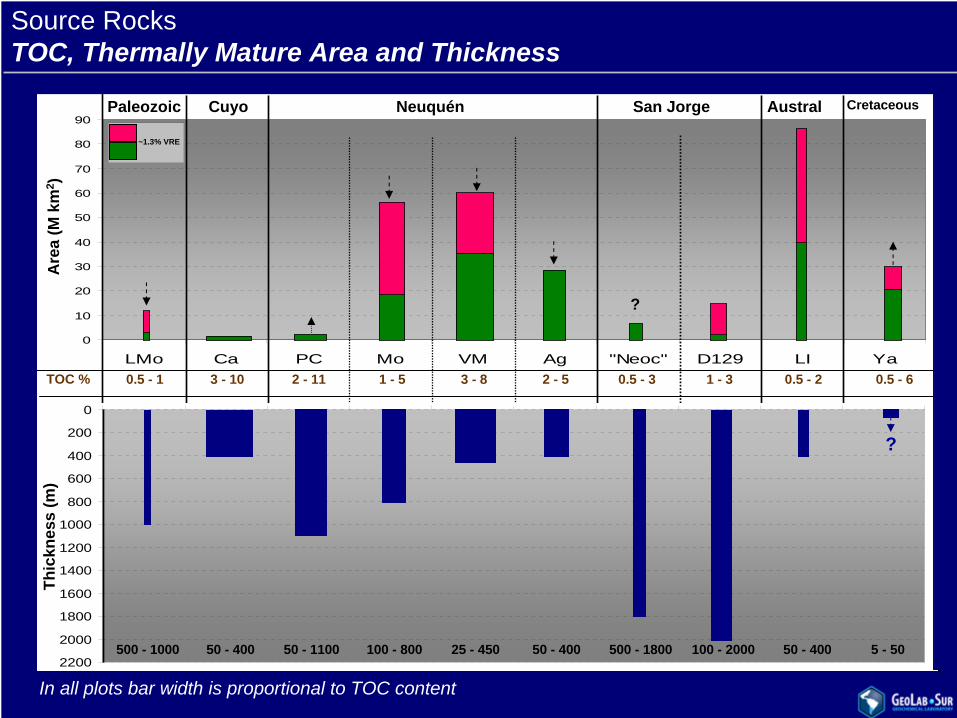
Source RocksTOC, Thermally Mature Area and Thickness
Depth(m)
0
10
20
30
40
50
60
70
80
90
LMo Ca PC Mo VM Ag "Neoc" D129 LI Ya
San Jorge Austral CretaceousNeuquénCuyoPaleozoic
TOC %
Are
a (M
km
2 )
0.5 - 1
~1.3% VRE
3 - 10 2 - 11 1 - 5 3 - 8 2 - 5 0.5 - 2 0.5 - 60.5 - 3 1 - 3
?
0
200
400
600
800
1000
1200
1400
1600
1800
2000
2200500 - 1000 50 - 400 50 - 1100 100 - 800 25 - 450 50 - 400 500 - 1800 100 - 2000 50 - 400 5 - 50
Thic
knes
s (m
)
?
In all plots bar width is proportional to TOC content

0
200
400
600
800
1000
1200
1400
1600
1800
2000
LMo Ca PC Mo VM Ag "Neoc" D129 LI Ya
Org
anic
Car
bon
Mas
s (T
ons
. 101
5 )
Source Rock
Paleozoic Cuyo Neuquén San Jorge Austral Cretaceous
Source RocksOrganic Richness and Oil & Gas EUR
2.0
1.3
0.6IMMATURE to EARLY MATURE
OIL WINDOW
WET GAS & CONDENSATE
DRY GAS2.0
1.3
0.6IMMATURE to EARLY MATURE
OIL WINDOW
WET GAS & CONDENSATE
DRY GAS
50 km
EUR:MMblsTCF
39512.2
Pz
BOLIVIA
ARGENTINA
50 km
22º
24º
64º 62ºBOLIVIA
ARGENTINA
50 km
22º
24º
22º
24º
64º 62º64º 62º
1200.2
K
3,4602.2
SJ
50 km
HuinculZapala
Chos Malal
Malargue
50 km50 km
HuinculZapala
Chos Malal
Malargue
50 km50 km
HuinculZapala
Chos Malal
Malargue
50 km50 km
HuinculZapala
Chos Malal
Malargue
50 km
HuinculZapala
Chos Malal
Malargue
50 km50 km
HuinculZapala
Chos Malal
Malargue
50 km50 km
HuinculZapala
Chos Malal
Malargue
50 km50 km
HuinculZapala
Chos Malal
Malargue
3,30015.9
Nq
57010.2
Au
69º
33º
Mendoza
Santa Rosa
Tunuyan
San Carlos
50 km69º
33º
Mendoza
Santa Rosa
Tunuyan
San Carlos
50 km50 km
1,2400.3
Cu
01000
2000
3000
4000
5000
6000
7000
8000
Thickness (m)
TOC %
Depth(m)
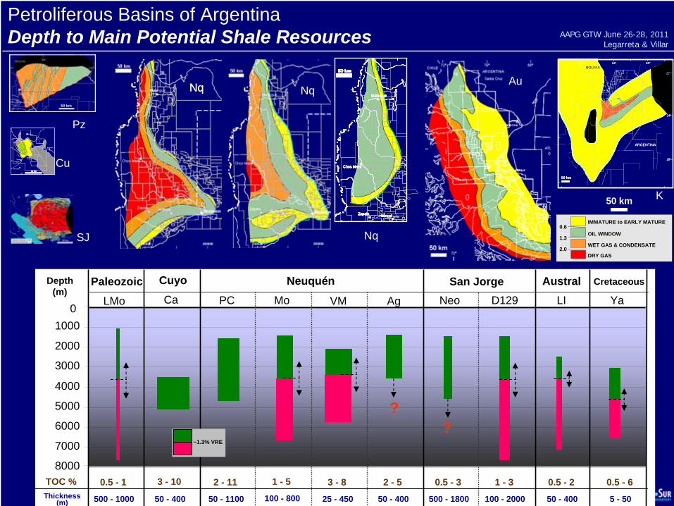
Petroliferous Basins of ArgentinaDepth to Main Potential Shale Resources
2.0
1.3
0.6IMMATURE to EARLY MATURE
OIL WINDOW
WET GAS & CONDENSATE
DRY GAS2.0
1.3
0.6IMMATURE to EARLY MATURE
OIL WINDOW
WET GAS & CONDENSATE
DRY GAS
LMo
Paleozoic
500 - 1000
0.5 - 1
Pz
Neo D129
San Jorge
?
500 - 1800 100 - 2000
0.5 - 3 1 - 3
SJ
LI
Austral
50 - 400
0.5 - 2
Au
69º
33º
Mendoza
Santa Rosa
Tunuyan
San Carlos
50 km69º
33º
Mendoza
Santa Rosa
Tunuyan
San Carlos
50 km50 km
Ca
Cuyo
50 - 400
3 - 10
Cu
VM
25 - 450
3 - 8
Nq
50 km
HuinculZapala
Chos Malal
Malargue
50 km50 km
HuinculZapala
Chos Malal
Malargue
50 km50 km
HuinculZapala
Chos Malal
Malargue
50 km50 km
HuinculZapala
Chos Malal
Malargue
50 km
HuinculZapala
Chos Malal
Malargue
50 km50 km
HuinculZapala
Chos Malal
Malargue
50 km50 km
HuinculZapala
Chos Malal
Malargue
50 km50 km
HuinculZapala
Chos Malal
Malargue
Ag
?
50 - 400
2 - 5
Nq
PC Mo
Neuquén
50 - 1100 100 - 800
2 - 11 1 - 5
NqNq
~1.3% VRE
50 km
Ya
Cretaceous
5 - 50
0.5 - 6
K
64º66º 62º
22º
24º
28º
BOLIVIA
ARGENTINA
50 km
64º66º 62º
22º
24º
28º
BOLIVIA
ARGENTINA
50 km
AAPG GTW June 26-28, 2011Legarreta & Villar
Geological and Geochemical Keys of the Potential Shale ResourcesHighlights
Review of the source rocks (1990-2010 published data) is based on the organic type and content, thermal maturity, thickness, area of distribution and present-day depth
Three source rocks seem to have a high potential for unconventional oil and gas resources (Los Molles, Vaca Muerta and Agrio, Neuquén)
The D-129 (San Jorge) source bears a huge thickness within the gas window but localized at a significant depth
Other sources show either significant thickness (Los Monos – Paleozoic) or widespread distribution (Lower Inoceramus - Austral) but limited TOC content
Cacheuta (Cuyo), Pre-Cuyo (Neuquén), Tobifera (Austral) and “Neocomiano” (San Jorge) are mostly oil-prone and display reduce areal distribution
Yacoraite (Cretaceous) contains a reduced thickness of thin source beds alternating with limestones, circumscribed to an internal and deep position in the basin
Finally, in basins such as Cañadón Asfalto, Ñirihuau, Chaco-Paranense, Claromecó, Precordillera (San Juan), Triassic Troughs (San Juan-La Rioja), Curamallin (Neuquén) further studies need to be done
AAPG GTW June 26-28, 2011Legarreta & Villar