Iniciativa de Monitoreo Socio-ecológico de la Amazonía … · Iniciativa de Monitoreo...
20
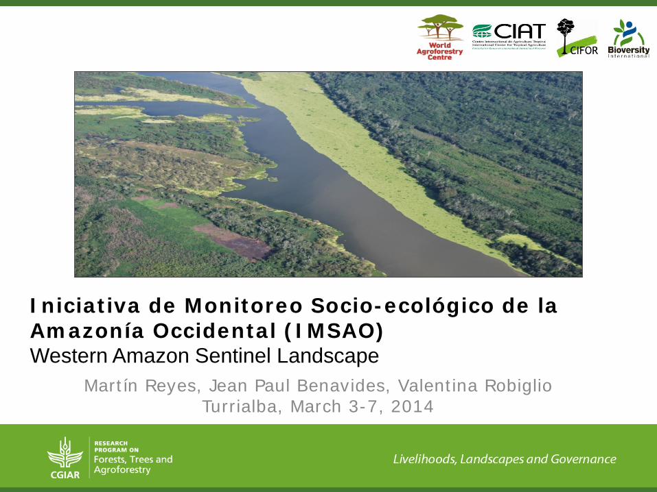
Martín Reyes, Jean Paul Benavides, Valentina Robiglio Turrialba, March 3-7, 2014 Iniciativa de Monitoreo Socio-ecológico de la Amazonía Occidental (IMSAO) Western Amazon Sentinel Landscape
Transcript of Iniciativa de Monitoreo Socio-ecológico de la Amazonía … · Iniciativa de Monitoreo...
Martín Reyes, Jean Paul Benavides, Valentina Robiglio Turrialba, March 3-7, 2014
Iniciativa de Monitoreo Socio-ecológico de la Amazonía Occidental (IMSAO) Western Amazon Sentinel Landscape

IMSAO study area
Pucallpa
Pto. Maldonado
Cobija
Rio Branco

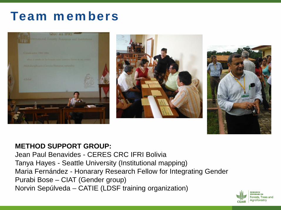
Team members
INTERNATIONAL TEAM MEMBERS Coordination: Valentina Robiglio CG centres focal points: Glenn Hyman, Ashwin Ravikumar, Evert Thomas, Martin Reyes
Team members
METHOD SUPPORT GROUP: Jean Paul Benavides - CERES CRC IFRI Bolivia Tanya Hayes - Seattle University (Institutional mapping) Maria Fernández - Honarary Research Fellow for Integrating Gender Purabi Bose – CIAT (Gender group) Norvin Sepúlveda – CATIE (LDSF training organization)
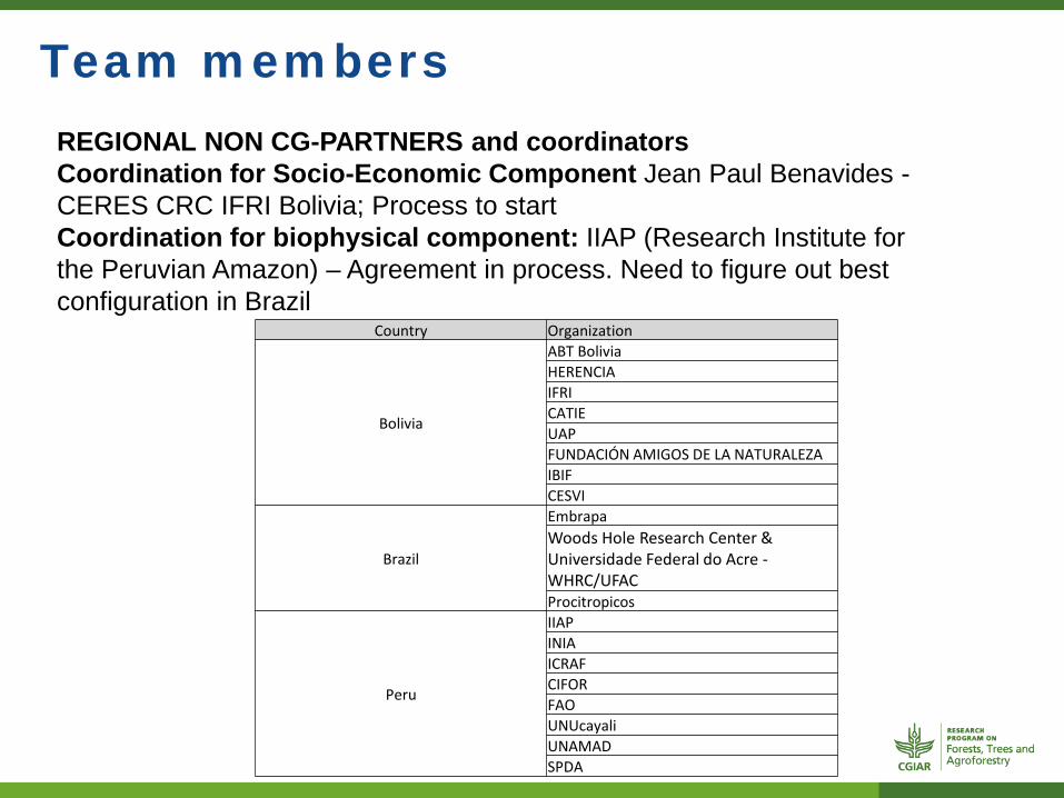
Team members REGIONAL NON CG-PARTNERS and coordinators Coordination for Socio-Economic Component Jean Paul Benavides - CERES CRC IFRI Bolivia; Process to start Coordination for biophysical component: IIAP (Research Institute for the Peruvian Amazon) – Agreement in process. Need to figure out best configuration in Brazil
Country Organization
Bolivia
ABT Bolivia HERENCIA IFRI CATIE UAP FUNDACIÓN AMIGOS DE LA NATURALEZA IBIF CESVI
Brazil
Embrapa Woods Hole Research Center & Universidade Federal do Acre - WHRC/UFAC Procitropicos
Peru
IIAP INIA ICRAF CIFOR FAO UNUcayali UNAMAD SPDA

Progresses
Output Activity Status Outputs
6.7.1.1: A network of priority landscapes selected
Inventory of legacy data and information about availability
Ongoing N. Of data set compiled and archived you have uploaded
reports
Database of ongoing projects
Ongoing List of activitites, partnerships and study sites per organization
6.7.1.3: Produce a data set that will be widely used and referred to by both donors and partners
Partner engagement
Ongoing Partner identification in Peru CERES IFRI colaboration in Bolivia
Discussions in progress with potential Brazilian partners
Proof of concepts for various methodologies
Ongoing Institutional Mapping Methodology Review (Seattle University)
….

Progresses
Partner Meetings Outputs y organizations
November 2012 Existing scondary datasets per region/country
November 2013 ONLY PERU
Common and agreed interests on 4 resource management outcomes
February 2014 Site selection
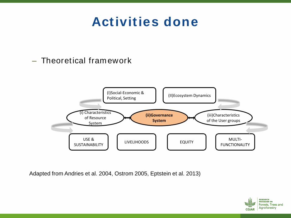
Activities done
– Theoretical framework
(I)Social-Economic & Political, Setting
(i) Characteristics of Resource
System
(ii)Governance System
(iii)Characteristics of the User groups
(II)Ecosystem Dynamics
USE & SUSTAINABILITY LIVELIHOODS EQUITY MULTI-
FUNCTIONALITY
Adapted from Andries et al. 2004, Ostrom 2005, Eptstein et al. 2013)

SL Site selection
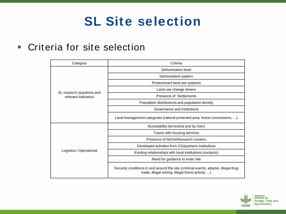
SL Site selection
Criteria for site selection Category Criteria
SL research questions and relevant indicators
Deforestation level
Deforestation pattern
Predominant land use systems
Land use change drivers
Presence of Settlements
Population distributions and population density
Governance and institutions
Land management categories (natural protected area, forest concessions, …)
Logistics / Operational
Accessibility (terrestrial and by river)
Towns with housing services
Presence of NGOs/Research Centers
Developed activities from CG/partners institutions
Existing relationships with local institutions (contacts)
Need for guidance to enter site
Security conditions in and around the site (criminal events, attacks, illegal drug trade, illegal mining, illegal forest activity …)
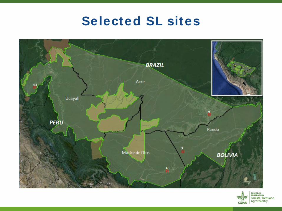
Selected SL sites
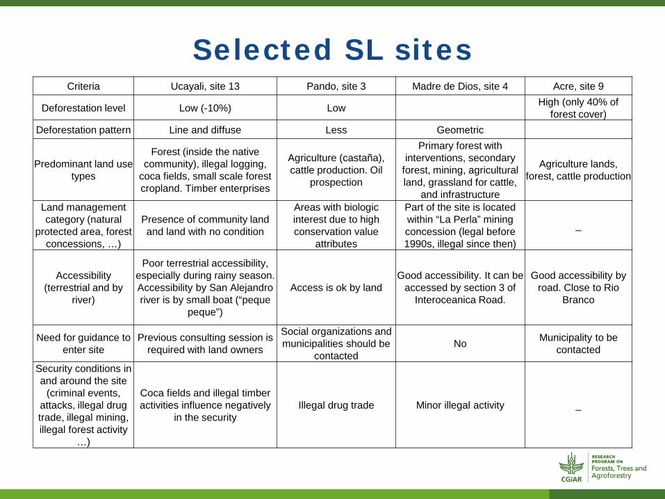
Selected SL sites Criteria Ucayali, site 13 Pando, site 3 Madre de Dios, site 4 Acre, site 9
Deforestation level Low (-10%) Low High (only 40% of forest cover)
Deforestation pattern Line and diffuse Less Geometric
Predominant land use types
Forest (inside the native community), illegal logging,
coca fields, small scale forest cropland. Timber enterprises
Agriculture (castaña), cattle production. Oil
prospection
Primary forest with interventions, secondary
forest, mining, agricultural land, grassland for cattle,
and infrastructure
Agriculture lands, forest, cattle production
Land management category (natural
protected area, forest concessions, …)
Presence of community land and land with no condition
Areas with biologic interest due to high conservation value
attributes
Part of the site is located within “La Perla” mining concession (legal before 1990s, illegal since then)
_
Accessibility (terrestrial and by
river)
Poor terrestrial accessibility, especially during rainy season. Accessibility by San Alejandro river is by small boat (“peque
peque”)
Access is ok by land Good accessibility. It can be
accessed by section 3 of Interoceanica Road.
Good accessibility by road. Close to Rio
Branco
Need for guidance to enter site
Previous consulting session is required with land owners
Social organizations and municipalities should be
contacted No Municipality to be
contacted
Security conditions in and around the site
(criminal events, attacks, illegal drug trade, illegal mining, illegal forest activity
…)
Coca fields and illegal timber activities influence negatively
in the security Illegal drug trade Minor illegal activity _

Selected SL sites
Ucayali
Madre de D
ios P
ando
A
cre
Logged over forest
annual crops grassland c
Old growth forest
Secondary forest and AFs
Car
bon
stoc
k M
g/ha
Ucayali site
Pando site
MDD site
Acre site
ONGOING WORK
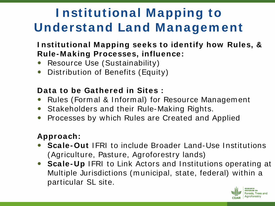
Institutional Mapping to Understand Land Management
Institutional Mapping seeks to identify how Rules, & Rule-Making Processes, influence: Resource Use (Sustainability) Distribution of Benefits (Equity) Data to be Gathered in Sites : Rules (Formal & Informal) for Resource Management Stakeholders and their Rule-Making Rights. Processes by which Rules are Created and Applied Approach: Scale-Out IFRI to include Broader Land-Use Institutions
(Agriculture, Pasture, Agroforestry lands) Scale-Up IFRI to Link Actors and Institutions operating at
Multiple Jurisdictions (municipal, state, federal) within a particular SL site.

Gender +
To integrate gender perspective into studies. The household surveys differentiate the data by gender,
but it’s uncertain if we’ll be able to obtain gender differentiated perspectives from them.
Institutional mapping in the communities can assess how community decision-processes influence gendered participation in natural resource management, & access and rights to the resources.
The institutional mapping, that will be done with groups, may also provide an opportunity to examine intra and inter household/production unit relations and processes from a gender perspective (still under discussion).
Work still needs to be done on the community-level data gathering mechanisms to ensure the inclusion of gendered perspectives and perceptions of the resource management processes.
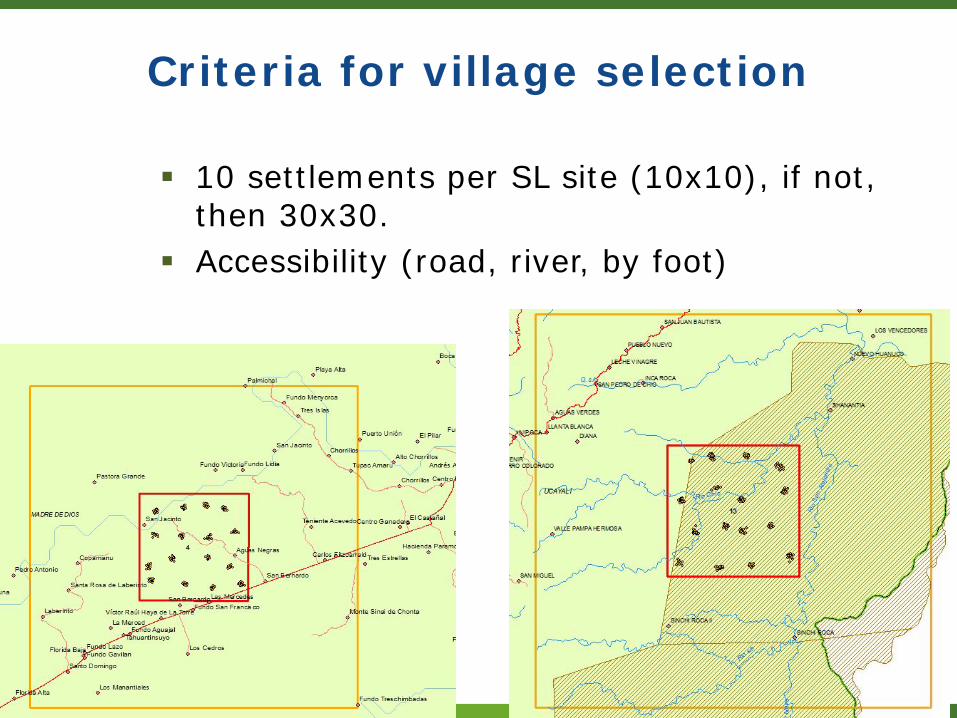
Criteria for village selection
10 settlements per SL site (10x10), if not, then 30x30.
Accessibility (road, river, by foot)

COMING ACTIVITIES
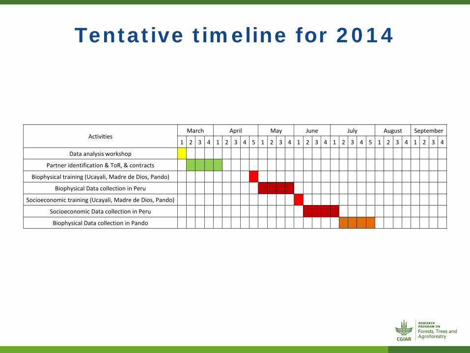
Tentative timeline for 2014
Activities March April May June July August September
1 2 3 4 1 2 3 4 5 1 2 3 4 1 2 3 4 1 2 3 4 5 1 2 3 4 1 2 3 4
Data analysis workshop
Partner identification & ToR, & contracts
Biophysical training (Ucayali, Madre de Dios, Pando)
Biophysical Data collection in Peru
Socioeconomic training (Ucayali, Madre de Dios, Pando)
Socioeconomic Data collection in Peru
Biophysical Data collection in Pando
Thank you