GIPUZKOA - UROLA KOSTA Camino de Santiago … de Santiago por la Costa GIPUZKOA - UROLA KOSTA Mapa...
36
Camino de Santiago por la Costa GIPUZKOA - UROLA KOSTA Mapa del recorrido Mapa del recorrido Mapa del recorrido Perfil de la etapa Mapa del recorrido Descripción del recorrido Mapa del recorrido Mapa del recorrido Todos los alojamientos Oficina de turismo Mapa del recorrido Restaurantes Mapa del recorrido Alojamiento de peregrinos Zarautz Getaria Zumaia Deba Orio San Sebastián ETAPA Donostia
Transcript of GIPUZKOA - UROLA KOSTA Camino de Santiago … de Santiago por la Costa GIPUZKOA - UROLA KOSTA Mapa...

Camino de Santiago por la Costa
GIPUZKOA - UROLA KOSTA
Mapa delrecorrido
Mapadel recorrido
Mapa delrecorridoPerfil de la
etapaMapa delrecorridoDescripción del recorrido
Mapa delrecorrido
Mapa delrecorrido
Todos los alojamientos
Oficina de turismo
Mapa delrecorrido
RestaurantesMapa delrecorridoAlojamiento
de peregrinos
Zarautz Getaria Zumaia Deba Orio San Sebastián
ETAPA
Donostia
INICIOMapa delrecorrido
Mapa delrecorrido
1
Mapa 1 Orio San Sebastián
ETAPA
Donostia
Mapa 2Mapa delrecorrido

2
INICIOMapa delrecorrido
Mapa delrecorrido
Mapa 2 Orio San Sebastián
ETAPA
Donostia
Mapa 1Mapa delrecorrido

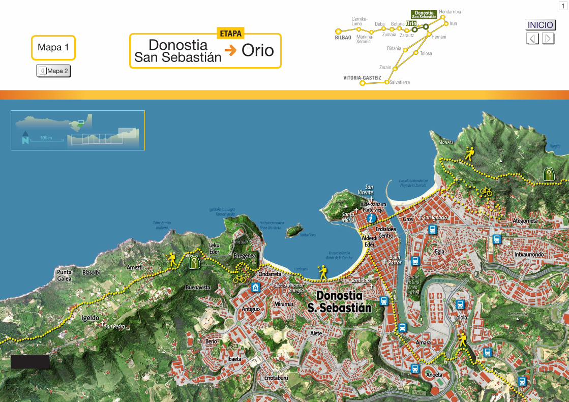
La Concha Donostia / San Sebastián
Alderdi Eder Miramar
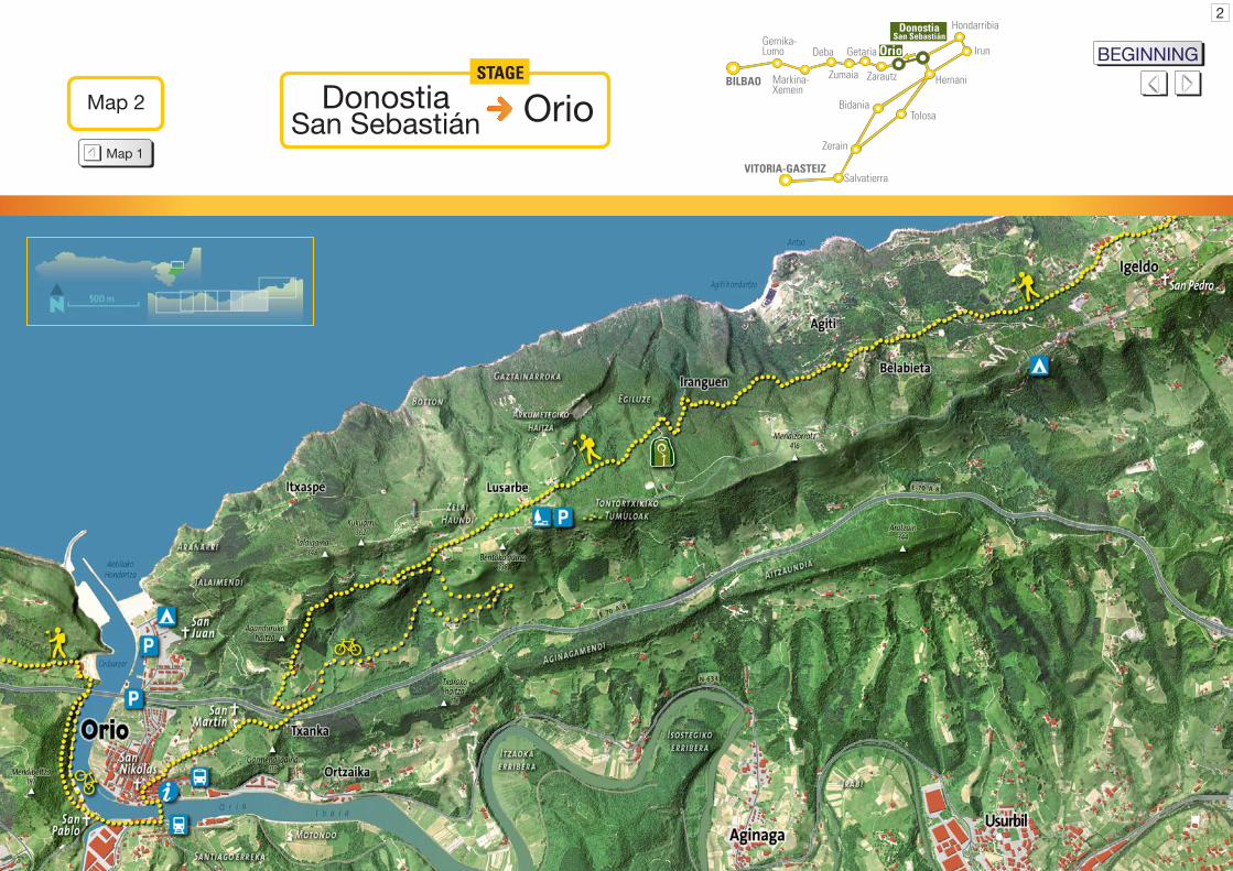
Situando el comienzo de etapa en Alderdi Eder, lugar central de la capital guipuzcoana abierto al Cantábrico, el inicio del itinerario rodea toda la bahía de la Concha hasta cerca de su final. Nos hallamos ante un paisaje que ha cambiado notoriamente desde la época de las primeras peregrinaciones, pero donde todavía podemos encontrar huellas de ese pasado. Se nos presenta por ejemplo en el promontorio que separa ambas playas un nombre de leyenda, Loretopea, y que significa “lugar bajo la virgen de Loreto”. El topónimo nos recuerda a la antigua ermita allí situada y dedicada a dicha virgen. Este escarpe, ahora coronado por el palacio de Miramar y atravesado por dos túneles, era antiguamente sorteado por un camino que lo remontaba, y que accedía así hasta el monasterio de San Sebastián el
Con un pequeño esfuerzo de imaginación podemos tratar de trasladarnos a ese pasado lejano, y así recrear e imaginarnos la zona de Ondarreta dibujada por un paisaje muy distinto al actual: una vega definida por humedales y cruzada por un río conocido por los nombres de Gorga o Konporta, curso que desembocaba en la mitad
3
Antiguo sobre él situado. Es precisamente este antiguo convento el que nos aporta los primeros recuerdos de aquel periodo medieval en el que florecieron las peregrinaciones a Santiago de Compostela. Las primeras noticias de este monasterio de San Sebastián el Antiguo datan de principios del siglo XII, y sería por ello el enclave que habría dado nombre a la actual capital. El monasterio de San Sebastián el Antiguo acogió a numerosos peregrinos desde época medieval, atestiguando la importancia del camino en aquella época.
Los reyes de Navarra donaron este monasterio al de San Salvador de Leire, una de las instituciones político-religiosas más poderosas de todo el reino, y que, gracias a su ubicación estratégica, controlaba muchas de las principales rutas del Camino de Santiago, vías que atravesaban los Pirineos por territorio navarro. El propio monasterio de San Sebastián poseía por su parte importantes dominios, que comprendían, a mediados del siglo XII, todo el territorio que se extendía desde la bahía de la Concha hasta la desembocadura del río Oria, incluyendo todos sus recursos y bienes como aguas, montes, tierras de labranza, pastos y manzanales.
INICIOMapa delrecorrido
Mapa delrecorrido
0 km0 m100
200
300
400
15 16105
Alde
rdi E
der
Onda
rret
a
Leku
Ede
rBu
ena
Vist
a
Bela
biet
a
OrioSa
n M
artin
Lusa
rbe
Irang
uen
16 km
Orio San Sebastián
ETAPA
Donostia

de lo que hoy es la playa. En este preciso lugar se ubicaba además una imponente nasa, estructura de maderas hincadas en el fondo del cauce del río a modo de redes de madera, y que aquí se empleaba para pescar salmones. Estas instalaciones pertenecieron en un inicio al propio monasterio, si bien a partir de la fundación de la villa de San Sebastián, hacia fines del siglo XII, pasarían a engrosar las posesiones de la población. En adelante, fue el concejo o ayuntamiento de la villa de San Sebastián el que durante siglos se encargó de reparar y mantener en explotación la nasa de Ondarreta, cuyos restos han sido descubiertos en fechas recientes.
El monasterio fue desde el siglo XVI convento de Dominicas, función que cumplió hasta que durante la Primera Guerra Carlista (1833-39) quedó arrasado. Finalmente, el emplazamiento donde yacían las ruinas del antiguo convento fue escogido por la Reina María Cristina para construir el Palacio de Miramar como residencia veraniega. El edificio fue proyectado por el arquitecto inglés Selden Wornum y erigido entre 1888 y1893. La familia real continuó acudiendo al palacio hasta bien entrado el siglo XX.
Continuando en ruta por Ondarreta y una vez atravesada la bahía, el camino comienza su ascenso a través de la ladera del monte Igeldo. Bordearemos primero el conjunto residencial de Erregenea, y ascenderemos después a través del parque del mismo nombre al monte Igeldo.
Belabieta - Agiti Lusarbe
Igeldo Igeldo
En la parte final de la cadena costera que aquí comienza, destaca como uno de sus primeros hitos la torre de Igeldo, testigo de un pasado en el que la vigilancia del mar era de crucial importancia. Fue construida por el Consulado de San Sebastián en el siglo XVIII, y su función consistía en atender las necesidades que generaba el intenso tráfico naval que caracterizaba a la ciudad. Se trata por ello uno de los faros más antiguos de la costa vasca, si bien, durante las dos guerras civiles del siglo XIX, formó parte del conjunto de fortificaciones construidas para defender la ciudad de los ataques carlistas. Finalmente, ya a principios del siglo XX, fue remodelado como mirador del parque de atracciones de Igeldo, y destinado así a hacer las delicias de aquellos veraneantes de la época dorada del turismo donostiarra gracias a sus magníficas panorámicas.
Una parte de esta ruta sigue el antiguo camino que comunicó durante siglos San Sebastián con Orio y las restantes localidades litorales del oeste de Gipuzkoa. La senda que hemos tomado nos conduce así hasta el hotel Leku Eder, ubicado junto a la carretera que accede a Igeldo. Superado el primer y principal repecho del recorrido, desde el hotel Leku Eder se ha de seguir temporalmente junto a la carretera de Igeldo, por cuya acera avanzaremos durante unos 700 metros hasta el restaurante Buenavista. Al pie del mismo parte un camino vecinal que avanza a media ladera entre villas, caseríos, huertas y praderas, un bello y agradable paseo con el mar siempre a la vista.
4
INICIOMapa delrecorrido
Mapa delrecorrido
Aganduru San Martin
La piedra era transportada principalmente por vía marítima y cargada en embarcaderos situados en lugares como la cala de Agiti, al pie del camino por el que avanzamos. Hoy día nada queda de dicha actividad de la cantería, salvo memorias en las generaciones mayores y las grandes canteras abandonadas, ya cubiertas por una exuberante vegetación, conquista de la naturaleza que les otorga un halo de misterio y atractivo.
En nuestro recorrido toparemos con una señal que indica el desvío hacia el cercano pueblo de Igeldo. Su parroquia, dedicada a San Pedro, contiene algunas de las escasas manifestaciones de estilo románico conservadas en Gipuzkoa, como es un ventanal de la Alta Edad Media.
De nuevo en nuestro itinerario jacobeo continuaremos avanzando por tranquilas pistas y caminos hasta situarnos primero a la altura de la cala de Agiti ya mencionada antes, y bajo la cumbre del monte Mendizorrotz después, monte coronado por los restos de un fuerte de la última guerra carlista.
El camino sigue avanzando a media ladera, y así, poco a poco, adquiere un carácter más solitario, aunque no pasará mucho tiempo hasta que avanzando por tranquilas pistas la presencia de varios caseríos nos
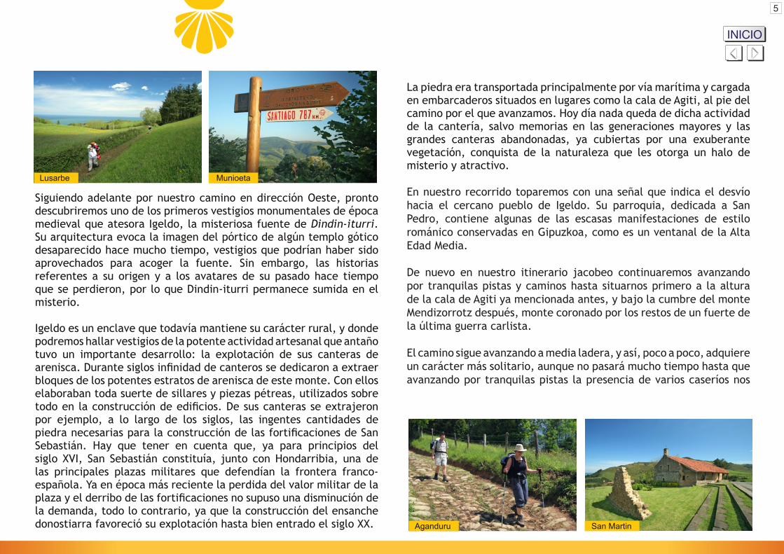
Siguiendo adelante por nuestro camino en dirección Oeste, pronto descubriremos uno de los primeros vestigios monumentales de época medieval que atesora Igeldo, la misteriosa fuente de Dindin-iturri. Su arquitectura evoca la imagen del pórtico de algún templo gótico desaparecido hace mucho tiempo, vestigios que podrían haber sido aprovechados para acoger la fuente. Sin embargo, las historias referentes a su origen y a los avatares de su pasado hace tiempo que se perdieron, por lo que Dindin-iturri permanece sumida en el misterio.
Igeldo es un enclave que todavía mantiene su carácter rural, y donde podremos hallar vestigios de la potente actividad artesanal que antaño tuvo un importante desarrollo: la explotación de sus canteras de arenisca. Durante siglos infinidad de canteros se dedicaron a extraer bloques de los potentes estratos de arenisca de este monte. Con ellos elaboraban toda suerte de sillares y piezas pétreas, utilizados sobre todo en la construcción de edificios. De sus canteras se extrajeron por ejemplo, a lo largo de los siglos, las ingentes cantidades de piedra necesarias para la construcción de las fortificaciones de San Sebastián. Hay que tener en cuenta que, ya para principios del siglo XVI, San Sebastián constituía, junto con Hondarribia, una de las principales plazas militares que defendían la frontera franco-española. Ya en época más reciente la perdida del valor militar de la plaza y el derribo de las fortificaciones no supuso una disminución de la demanda, todo lo contrario, ya que la construcción del ensanche donostiarra favoreció su explotación hasta bien entrado el siglo XX.
Lusarbe Munioeta
5
INICIOMapa delrecorrido
Mapa delrecorrido

San Martin Orio - Via Crucis
señale el inicio del término de Orio. Algunos de estos caseríos, como por ejemplo Lusarbe, Munioeta o Aganduru, son de gran antigüedad, ya que son citados desde el siglo XII. Pronto cruzaremos el cordal costero hacia el interior, y pasaremos cerca de las Ventas de Orio, nombre que proviene de las antiguas instalaciones de asistencia en los caminos donde los viajeros hallaban alojamiento y comida, lugares en los que también se realizaban todo tipo de compraventas. El caserío Benta sigue rindiendo tributo a la tradición al ser un establecimiento hostelero muy frecuentado.
Penetramos así en la cuenca baja del río Oria, el más largo y caudaloso de Gipuzkoa. El Oria, tras haber recorrido en dirección Sur-Norte parte importante del interior del territorio de Gipuzkoa, experimenta al llegar al pie del monte Igeldo un radical cambio de dirección, y en adelante discurre de forma paralela al mar y a la cadena costera por la que transitamos, describiendo grandes meandros en su inexorable camino a la cercana desembocadura. Este trayecto nos deleita con una vista magnífica sobre todo el valle bajo del Oria.
Después de una breve sección de recorrido por la carretera, ya en el descenso hacia Orio, comenzará uno de los tramos de calzada mejor conservados de todo el camino, que desciende en pronunciada pendiente hasta alcanzar el caserío Aganduru. Este caserío aparece citado por primera vez en el siglo XII, y se describe entre las propiedades ubicadas entre Igeldo y Orio donadas por el rey de Pamplona García V el Restaurador al gran monasterio navarro de San Salvador de Leire, datos que son un buen indicador de la antigüedad de la calzada por la que transitamos.
San Martin Orio - Aia
6
Tras dejar atrás el caserío Aganduru, continuaremos por una pista asfaltada hasta el fondo del pequeño valle del río Txanka. En este punto, tras pasar bajo el puente de la autopista A-8, continuaremos por la cuesta que asciende hacia nuestra derecha. Tras el pequeño repecho alcanzaremos la bella y antiquísima ermita de San Martin de Tours, santo protector de viandantes y peregrinos. Se trata de una hermosa ermita situada en un emplazamiento privilegiado, en la cumbre de una colina y con vistas a la desembocadura del Oria en el mar, en la antesala del casco histórico de Orio.
Siguiendo el vía crucis que jalona el camino, en lo que en su tiempo fue el camino principal que llegaba a Orio desde San Sebastián, encontraremos preciosos edificios del siglo XVI construidos con un gusto claramente marinero. Nos adentraremos así en el centro medieval de la villa a través de la calle principal de Orio, Kale Nagusia o “Calle Mayor”, jalonada por numerosas casas solariegas. Nada más penetrar en ella nos encontraremos, a nuestra derecha, con los vestigios del antiguo hospital. Este edificio, adscrito a la advocación de Nuestra Señora de la Piedad, acogió durante siglos a peregrinos, viajeros, y demás transeúntes necesitados de asistencia, ya que Orio fue un enclave de tradicional acogida a los peregrinos. Por ejemplo en el siglo XVI este antiguo hospital de la Piedad o Piedadia contaba con un hospitalero y una veintena de camas, y cobijaba tanto a pobres como a peregrinos, algunos de los cuales acudían desde lugares muy lejanos.
INICIOMapa delrecorrido
Mapa delrecorrido

OrioSan Nikolas
San NikolasKale Nagusia / Calle Mayor
nivel de la orilla. No es de extrañar que una parte de esta gran estructura cumpliera las funciones de atalaya, permitiendo la observación de lo que acontecía en la desembocadura del Oria y sirviendo a la función de recibir las señales emitidas desde la atalaya principal de Orio, o probablemente también desempeñando funciones defensivas.
La calle principal abocaba originalmente en la ría, donde existía un embarcadero en el que la villa tenía dispuesto un servicio de pasaje. La barca destinada al transbordo era el único nexo de unión entre ambas orillas, y los viajeros, a falta de puentes, no tenían más remedio que alquilar sus servicios para alcanzar el otro margen de la ría. Sin embargo los peregrinos gozaban de un privilegio real que les eximía del pago de un maravedí por cruzarla, lo que es reflejo de la importancia que tuvo la ruta jacobea en aquella época.
El trazado urbano de la villa de Orio es resultado de aglutinar tres elementos de importancia capital en una única articulación urbana: el camino principal procedente de San Sebastián, que se prolonga por Kale Nagusia; la parroquia de San Nikolas, erigida en un peñasco sobre las aguas del Oria; y el puerto viejo, que se ubicaba en una cala, actualmente colmatada, junto a dicho peñasco. El recinto original de la villa de Orio conserva además diversos edificios de los siglos XV, XVI y posteriores. Es interesante recorrer las empinadas y estrechas calles del casco histórico para disfrutar de todos estos elementos urbanísticos y arquitectónicos, pues aquí y allá encontraremos hermosas casas de pescadores y distinguidos palacios urbanos, en los que destacan escudos de armas, representaciones de embarcaciones y otros muchos elementos singulares. Todos ellos son fruto de lo que durante siglos constituyó el principal recurso económico y de desarrollo de los habitantes de Orio: las actividades ligadas al mar.
En nuestro descenso por Kale Nagusia llegaremos hasta la imponente mole de la parroquia de San Nikolas, obra renacentista de los siglos XVI y XVII. El templo se halla construido sobre una amplia plataforma, sostenida en parte por poderosos arcos que descansan sobre grandes pilares, a fin de adecuarse a la pendiente del terreno. Alrededor del templo se conforma un importante atrio perimetral, a la manera de un paso de ronda cubierto en toda su extensión, y que en el lado que da hacia la ría y su desembocadura, se alza a gran altura sobre el
7
INICIOMapa delrecorrido
Mapa delrecorrido

8
ALBERGUE DEPEREGRINOSArteta EtxeaBarrio San MartinTel.: 617 11 86 89E-mail: [email protected]
OFICINA DE TURISMO
Kale Nagusia, 1720810 OrioTel./Fax: 943 830 904E-mail: [email protected]
CENTRO DE INTERPRETACIÓNDEL CAMINO DE SANTIAGO
Kale nagusia, 17 - 20810 OrioTel./Fax: 943 830 904E-mail: [email protected]
ORIO
INICIOMapa delrecorrido
OR
IO Mapa delrecorridoTodos los
alojamientosMapa delrecorrido
Restaurantes

Kostaldeko Done Jakue Bidea
GIPUZKOA - UROLA KOSTA
Zarautz Getaria Zumaia Deba Orio San Sebastián
ETAPA
Donostia
Mapa delrecorridoIbilbidearen
mapaMapa delrecorridoIbilbidearen
profilaMapa delrecorridoIbilbidearen
deskribapenaMapa delrecorrido
Mapa delrecorridoOstatuak Turismo
bulegoaMapa delrecorridoJatetxeakMapa del
recorridoErromesentzako
aterpea

HASIERAMapa delrecorrido
Mapa delrecorrido
1
Mapa 1 Orio San Sebastián
ETAPA
Donostia
Mapa 2Mapa delrecorrido

2
Mapa 2 Orio San Sebastián
ETAPA
Donostia
Mapa 1Mapa delrecorrido
HASIERAMapa delrecorrido
Mapa delrecorrido

La Concha Donostia / San Sebastián
Alderdi Eder Miramar
Etapa hau Alderdi Ederren hasi dezakegu, Gipuzkoako hiriburuaren erdigunean hain zuzen, Kantauri itsasoaren aurrez aurre, eta ibilbideak Kontxako badia osoa inguratzen du ia bukaeraraino. Ikusgai dugun paisaia nabarmen aldatu da lehen erromesaldien garaitik, baina oraindik ere iragan horren arrastoak aurki ditzakegu nonahi. Badiako bi hondartzak bereizten dituen harkaitzak, esate baterako, Loretopea du izena, “Loretoko Ama Birjinaren azpiko lekua”, alegia. Toponimo horrek inguru hartan zegoen ermita gogorarazten digu, Loretoko Ama Birjinari eskainia. Muino malkartsu horren gainean Miramar jauregia aurkitzen da gaur egun, eta azpian, berriz, bi tunel egin dituzte, baina antzina bidexka batek inguratzen zuen, eta bide horretatik muinoaren gainean zegoen San Sebastián el Antiguo monasteriora irits zitekeen. Komentu zahar horrek eskaintzen dizkigu,
Irudimen pixka batekin, iragan urrun hartara jauzi egiten ahalegindu gaitezke, eta horrela Ondarreta inguruak gaur egungoaren guztiz bestelako paisaia batean murgilduta irudikatuko ditugu: hezegunez betetako ibar bat aurkitzen zen bertan, eta haren erditik Gorga edo Konporta izenez ezagutzen zen erreka bat igarotzen zen, gaur egungo hondartzaren erdialdean itsasoratzen zena.
3
hain zuzen ere, Donejakuerako erromesaldiak ugaritu ziren Erdi Aroko garai haien lehen oroitzapenak. Monasterioari buruzko lehen albisteak XII. mendekoak dira, eta, ondorioz, badirudi eraikin horrek eman ziola izena gaur egungo hiriburuari. San Sebastián el Antiguo monasterioak erromes askori eman zion ostatu Erdi Aroan, eta garai hartan Santiago bideak zuen garrantziaren lekuko inportantea da.
Nafarroako errege-erreginek Leireko San Salvador monasterioari eman zioten Donostiako monasterioa. Leirekoa Nafarroako erreinuko erakunde politiko-erlijioso boteretsuenetakoa zen, eta bere kokapen estrategikoari esker Santiago bideko ibilbide nagusi asko kontrolatzen zituen, Pirinioak nafar lurraldeetatik zeharkatzen zituzten bideak, hain zuzen. Donostiako monasterioak berak ere lursail garrantzitsuak kontrolatzen zituen; bereak ziren, XII. mendean, Kontxako badiatik Oria ibaiaren bokalerainoko lur guztiak, bertako baliabide eta ondasun guztiak barne, hots, urak, mendiak, laborantzarako lurrak, larreak, sagastiak eta beste.
0 km0 m100
200
300
400
15 16105
Alde
rdi E
der
Onda
rret
a
Leku
Ede
rBu
ena
Vist
a
Bela
biet
a
OrioSa
n M
artin
Lusa
rbe
Irang
uen
16 km
Orio San Sebastián
ETAPA
Donostia HASIERA
Mapa delrecorrido
Mapa delrecorrido

Gune jakin horretan, gainera, nasa handi bat aurkitzen zen, errekaren hondoko erretenean sartutako egurrezko egitura bat, egurrezko sare gisa erabiltzen zena izokina arrantzatzeko. Instalazio haiek monasterioarenak berarenak ziren hasiera batean, nahiz eta XII. mendearen bukaera aldean Donostia hiria sortu zenez geroztik hiriaren jabetza izatera igaro ziren. Handik aurrera, Donostia hiriko kontzejua edo udaletxea arduratu zen mendeetan zehar Ondarretako nasa konpontzeaz eta ustiapenean mantentzeaz. Nasa haren aztarnak ez dira orain dela gutxi arte aurkitu.
XVI. mendeaz geroztik, monasterioa Dominikarren komentu bilakatu zen, eta funtzio hori bete zuen Lehen Gerra Karlistan (1833-39) erabat suntsituta geratu zen arte. Azkenik, Maria Kristina erreginak komentu zaharraren arrastoak gelditzen ziren lekua aukeratu zuen bere udako etxea izango zen Miramar jauregia eraikitzeko. Eraikina Selden Wornum arkitekto ingelesak diseinatu zuen, eta 1888 eta 1893. urteen artean eraiki zen. Errege-familiak jauregira etortzen jarraitu zuen XX. mendea aski aurreratua zen arte.
Badia zeharkatu eta Ondarretatik jarraituz, gure ibilbideak Igeldo mendiaren hegalean gora eramango gaitu. Erregeneako bizitegi-gunea inguratuko dugu lehenik, eta ondoren, izen bereko parkea zeharkatuz, Igeldo mendira igoko gara.
Belabieta - Agiti Lusarbe
Igeldo Igeldo
Hemen hasten den itsasertzeko mendikatearen bukaera aldean Igeldoko dorrea aurkitzen da, mendikatearen lehen mugarrietako bat, itsasoari beha egoteak berebiziko garrantzia zuen iragan haren lekuko. Dorrea Donostiako Kontsulatuak eraiki zuen XVIII. mendean, eta bere zeregina hiriaren ezaugarri nagusia zen itsas trafiko handiak sortarazten zituen premiei erantzutea zen. Hori dela eta, Euskal Herriko itsasertzeko itsasargi zaharrenetakoa da, nahiz eta, XIX. mendeko bi gerra zibiletan, hiria karlisten erasoetatik babesteko eraikitako gotorleku-multzoaren zati izan zen. Azkenik, XX. mendearen hasieran birmoldatu egin zuten, eta harrezkero Igeldoko jolas-parkeko ikuspegi paregabeko begiratokia izan zen, Donostiako turismoaren urrezko aroko udatiarren gozamenerako.
Gure ibilbidearen zati batek bide zaharrari jarraitzen dio, Donostia mendeetan zehar Oriorekin eta Gipuzkoa mendebaldeko itsasertzeko beste herriekin komunikatzen zuen bideari, hain zuzen ere. Bidezidor honek Igeldora iristen den errepidearen ondoan dagoen Leku Eder hotelera eramango gaitu. Gainditu dugu dagoeneko ibilbidearen aldapa gogorrena. Leku Eder hotela igaro ondoren, Igeldoko errepidetik jarraituko dugu zati batean; espaloitik 700 bat metro egin ostean Buenavista jatetxera iritsiko gara. Jatetxearen ondotik auzo-bide bat abiatzen da, eta, mendi-hegaletik egiten du aurrera, txalet, baserri, baratz eta zelai artetik; paseo polit eta atsegina, itsasoa beti begien aurrean dugula.
4
HASIERAMapa delrecorrido
Mapa delrecorrido
Aganduru San Martin
Harria itsasoz garraiatzen zen nagusiki, eta horretarako Igeldoko zenbait portutan ontziratzen zuten, esaterako orain gabiltzan bide honen azpian aurkitzen den Agitiko kalan. Gaur egun hargintza-jarduera hura guztiz desagertuta dago; geratzen diren aztarna bakarrak belaunaldi zaharrenen oroitzapenak dira, eta abandonatuta utzitako harrobi handiak, landaretza oparo batek estaliak honezkero, naturaren konkistak eransten dien misterio eta xarma berezi horrekin.
Gure ibilbidean aurrera eginez, Igeldo herriranzko desbideratzea adierazten duen seinalearekin egingo dugu topo. Berehala ikusiko dugu Igeldoko eliza, San Pedrori eskainia, eta bertan Gipuzkoak gordetzen dituen estilo erromanikoaren adierazpen urrietako batzuk aurkituko ditugu, Goi Erdi Aroko leihatea besteak beste.
Berriro ere Santiago bideari helduz, inguru hauetako pista eta bidexka lasaietatik jarraituko dugu, lehen aipatutako Agiti kalaren pareraino helduz lehenik, eta Mendizorrotz tontorraren azpitik ondoren. Gailur horretan azken gerra karlistako gotorleku baten hondakinak aurkitzen dira.
Bideak mendi-hegaletik jarraitzen du aurrera, eta horrela, pixkanaka-pixkanaka, ingurune bakartiagoetan barneratuko gara; dena den, denbora gutxi beharko dugu pista lasaietatik barrena Orio herriaren muga adierazten diguten hainbat baserrirekin topo egiteko.
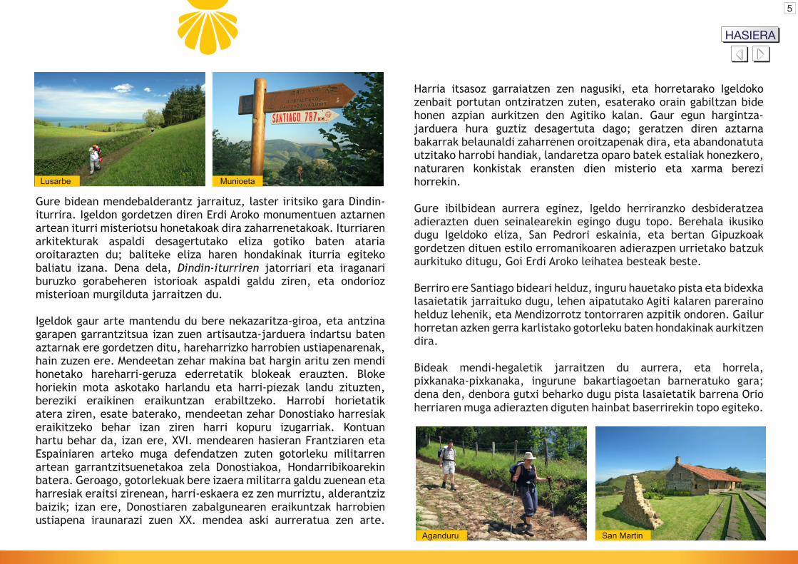
Gure bidean mendebalderantz jarraituz, laster iritsiko gara Dindin-iturrira. Igeldon gordetzen diren Erdi Aroko monumentuen aztarnen artean iturri misteriotsu honetakoak dira zaharrenetakoak. Iturriaren arkitekturak aspaldi desagertutako eliza gotiko baten ataria oroitarazten du; baliteke eliza haren hondakinak iturria egiteko baliatu izana. Dena dela, Dindin-iturriren jatorriari eta iraganari buruzko gorabeheren istorioak aspaldi galdu ziren, eta ondorioz misterioan murgilduta jarraitzen du.
Igeldok gaur arte mantendu du bere nekazaritza-giroa, eta antzina garapen garrantzitsua izan zuen artisautza-jarduera indartsu baten aztarnak ere gordetzen ditu, hareharrizko harrobien ustiapenarenak, hain zuzen ere. Mendeetan zehar makina bat hargin aritu zen mendi honetako hareharri-geruza ederretatik blokeak erauzten. Bloke horiekin mota askotako harlandu eta harri-piezak landu zituzten, bereziki eraikinen eraikuntzan erabiltzeko. Harrobi horietatik atera ziren, esate baterako, mendeetan zehar Donostiako harresiak eraikitzeko behar izan ziren harri kopuru izugarriak. Kontuan hartu behar da, izan ere, XVI. mendearen hasieran Frantziaren eta Espainiaren arteko muga defendatzen zuten gotorleku militarren artean garrantzitsuenetakoa zela Donostiakoa, Hondarribikoarekin batera. Geroago, gotorlekuak bere izaera militarra galdu zuenean eta harresiak eraitsi zirenean, harri-eskaera ez zen murriztu, alderantziz baizik; izan ere, Donostiaren zabalgunearen eraikuntzak harrobien ustiapena iraunarazi zuen XX. mendea aski aurreratua zen arte.
Lusarbe Munioeta
5
HASIERAMapa delrecorrido
Mapa delrecorrido

San Martin Orio - Via Crucis
Baserri horietako batzuk, Lusarbe, Munioeta edo Aganduru adibidez, aspaldiko garaietakoak dira, XII. mendean jada aipatzen baitziren. Berehala igaroko gara mendikatearen itsasoko aldetik barrualdera, eta Orioko Bentetatik pasatuko gara. “Bentak” izena garai batean bidean egoten ziren sorospenerako ostatuetatik datorkie; ostatu horietan jatekoa eta lo egiteko lekua aurkitzen zituzten bidaiariek, eta mota guztietako salerosketak ere egiten zituzten. Benta baserriak tradizioari gorazarre egiten dio oraindik ere, otordu garaian jende asko izaten baitute bertan.
Aurrera jarraituz, Oria ibaiaren behe-arroan sartuko gara; hauxe dugu Gipuzkoako ibairik luze eta emaritsuena. Gipuzkoaren barnealdearen zati handi bat hegoaldetik iparralderantz zeharkatu ondoren, norabidea erabat aldatzen du Igeldo mendiaren magalera iristean; hortik aurrera itsasoarekiko eta orain gabiltzan mendikatearekiko paraleloki jarraitzen du, gero eta gertuago daukan bokaleranzko joan etengabean meandro ikusgarriak eginez. Ibilbidearen zati honek Oria ibaiaren behe-ibar osoaren ikuspegi zoragarria eskaintzen digu.
Ibilbidearen zati labur bat errepidez egin ondoren, Orioranzko jaitsierari ekingo diogu, zati honetan oso ongi kontserbatuta dagoen galtzada batetik. Galtzada maldatsuan behera egingo dugu Aganduru baserrira iritsi arte. Badirudi baserri hau XII. mendean aipatzen dela lehen aldiz; Iruñeko errege Gartzia V.a “Berrezarleak” Leireko San Salvador (Salavador) monasterio handiari eman omen zion, Igeldoren eta Orioren artean aurkitzen diren beste hainbat ondasunen
San Martin Orio - Aia
6
HASIERAMapa delrecorrido
Mapa delrecorrido
artean. Datu horiek orain gabiltzan galtzadaren antzinakotasunaren adierazgarri argiak dira.
Aganduru baserria atzean utzi ondoren, Txanka errekaren ibar txikiaren barrenerantz jarraituko dugu pista asfaltatu batetik. Puntu horretara iritsita, eta A-8 autopistako zubiaren azpitik igaro ondoren, eskuinerantz igotzen den aldapatik jarraituko dugu. Malda txikia igo eta gero, Tourseko San Martin ermita zahar ederrera iritsiko gara; ibiltarien eta erromesen santu babeslearen ermita polit hau aparteko kokalekuan aurkitzen da, mendixka baten gailurrean eta Oriaren bokalearen aurrez aurre, Orio herriaren gune historikoaren atarian.
Aurrera eginez, bidea zedarritzen duten gurutzeei jarraituko diegu; garai batean gurutze-bide hauxe zen Donostiatik Oriora iristen zen bide nagusia. Bertan XVI. mendeko eraikin zoragarriak ikusiko ditugu, marinel-kutsu nabarmenarekin eraikiak. Herriaren gune historikoan barneratuko gara horrela, Orioko Kale Nagusian barrena, oinetxe ugariren artetik. Herrigunean sartu orduko eskuinera begiratzen badugu, ospitale zaharraren aztarnak ikusiko ditugu. Pietatearen Ama Birjinaren izena duen eraikin hau laguntza beharrean aurkitzen ziren erromes, bidaiari eta bestelako ibiltarien babesleku izan da mendeetan zehar, erromesen harrera-gune tradizionala izan baita Orio urteetan zehar. XVI. mendean, esate baterako, Piedadia deituriko ospitale zaharrak ospitalezain bat eta hogei bat ohe zituen,

OrioSan Nikolas
San NikolasKale Nagusia
perimetroa elizpe eder batek inguratzen du, bere luzera guztian estalita dagoen ingurabide moduko batek; ibaira eta bokalera ematen duen aldean, ingurabide horrek garaiera handia hartzen du ibaiertzaren mailarekiko. Ez da harritzekoa egitura handi horren zati batek talaia-funtzioak bete izana, Oria ibaiaren bokalean gertatzen zenari beha egoteko eta Orioko talaia nagusitik bidalitako seinaleak jasotzeko kokaleku ezin hobea baitzen; litekeena da, halaber, defentsa-funtzioetarako ere erabili izana.
Hasiera batean, Kale Nagusia ibaian bukatzen zen, eta bertan zegoen moila txiki batean ibaia zeharkatzeko zerbitzua ezarria zuen hiriak. Zeharkaldirako erabiltzen zen txalupa zen bi ibaiertzen arteko lotura bakarra, eta bidaiariek, zubirik ezean, ez zuten zerbitzu hura ordaindu beste aukerarik ibaiaren beste aldera iritsi nahi bazuten. Halere, erromesek errege-pribilegioa zuten, eta horri esker salbuetsita zeuden ibaia gurutzatzeko eskatzen zen marabedi bateko kostua ordaintzetik; erromesen pribilegioak argi aski islatzen du garai hartan Donejakue bideak zuen garrantzia.
7
HASIERAMapa delrecorrido
Mapa delrecorrido
eta behartsu nahiz erromesei ematen zien ostatu, baita oso urrutiko lekuetatik zetozenei ere.
Orio herriaren diseinua aztertzean, ohartuko gara garrantzi handiko hiru elementu hiri-artikulazio bakar batean elkartzen direla: Donostiatik datorren bide nagusia, aurrerago Kale Nagusi bilakatzen dena; San Nikolas eliza, Oria ibaiaren gaineko harkaitz batean eraikia; eta portu zaharra, gaur egun estalita dagoen kala batean kokatua, aipatu harkaitzaren ondoan. Orio herriaren jatorrizko eremuan, gainera, XV. eta XVI. mendeetako hainbat eraikin aurkitzen dira, baita geroagokoak ere. Interesgarria da herriaren gune historikoko kale maldatsu bezain estuetatik ibiltzea hirigintza eta arkitektura arloetako elementu horiez gozatu ahal izateko, nonahi aurkituko baititugu arrantzaleen etxe ederrak edota hiri-jauregi dotoreak, non arma-ezkutuak, ontzien irudiak eta beste hainbat elementu berezi nabarmentzen diren. Izan ere, horiexek izan dira mendeetan zehar Orioko biztanleen ekonomia- eta garapen-baliabide nagusiak: itsasoarekin lotutako jarduerak.
Kale Nagusian behera jarraituz, San Nikolas eliza ederraren aurrera iritsiko gara. XVI. eta XVII. mendeetan eraikitako eliza errenazentista hau plataforma zabal baten gainean dago finkatuta, eta zutabe handi batzuen gainean bermatutako hainbat arku sendok eusten dute neurri batean, zoruaren malkarrera egokitu ahal izateko. Parrokiaren

8
ERROMESENATERPETXEAArteta EtxeaSan Martin auzoaTel.: 617 11 86 89E-mail: [email protected]
TURISMO BULEGOA
Kale Nagusia, 1720810 OrioTel./Fax: 943 830 904E-maila: [email protected]
DONE JAKUE BIDEARENINTERPRETAZIO ZENTROA
Kale nagusia, 17 - 20810 OrioTel./Fax: 943 830 904E-maila: [email protected]
ORIOO
RIO
HASIERAMapa delrecorrido
Mapa delrecorridoOstatuak Mapa del
recorridoJatetxeak

Way of St James – Coastal Route
GIPUZKOA - UROLA KOSTA
Mapa delrecorrido
Stagemap
Mapa delrecorrido
Stageprofile
Mapa delrecorridoDescription Mapa del
recorridoMapa delrecorrido
Allaccommodation
Touristoffice
Mapa delrecorridoRestaurantsMapa del
recorridoPilgrim’shostel
Zarautz Getaria Zumaia Deba Orio San Sebastián
STAGE
Donostia

BEGINNINGMapa delrecorrido
Mapa delrecorrido
1
Map 1 Orio San Sebastián
STAGE
Donostia
Map 2Mapa delrecorrido
2
Map 2 Orio San Sebastián
STAGE
Donostia
Map 1Mapa delrecorrido
BEGINNINGMapa delrecorrido
Mapa delrecorrido

La Concha Donostia / San Sebastián
Alderdi Eder Miramar
Stage one begins in the centre of San Sebastián at Alderdi Eder overlooking the Bay of Biscay. The first stretch follows La Concha Bay almost all the way to the west end. Although the landscape has changed significantly since the time of the earliest pilgrimages, traces of the ancient past still remain. For example, the promontory that separates the two beaches is called Loretopea, a Basque word which means “place under the virgin of Loreto”. The place name refers to a chapel that once stood on this sight dedicated to Our Lady of Loreto. Today the escarpment is crowned by the Palacio Miramar and pierced by two tunnels. There used to be a road over the escarpment which led to the former monastery of San Sebastián,known as ‘el Antiguo’. It is precisely this religious community
from La Concha Bay to the mouth of the Oria River, together with all resources and assets, including water, cultivated and uncultivated lands, pastures and apple orchards.
If you use some imagination and let yourself be transported back in time, the area you see around Ondarreta today would look quite different – a fertile plain dominated by wetlands drained by
3
that gives us our first reminder of the Middle Ages, a time in which pilgrimages to Santiago de Compostela flourished. The first mention of the monastery dates to the early 12th century, and it is probably what gave the city of San Sebastián its name. The Monastery of San Sebastián ‘el Antiguo’ welcomed scores of pilgrims, bearing witness to the importance of the Way of St. James in medieval times.
The Navarrese monarchs granted San Sebastián el Antiguo to the Abbey of San Salvador de Leire, one of the most powerful political and religious institutions in the kingdom. Due to its strategic location, the Abbots at Leire controlled many of the main pilgrimage routes that crossed the Pyrenees through Navarrese territory. The monks at San Sebastián el Antiguo also controlled significant domains. In the mid-12th century the monastery owned the entire territory stretching
0 km0 m100
200
300
400
15 16105
Alde
rdi E
der
Onda
rret
a
Leku
Ede
rBu
ena
Vist
a
Bela
biet
a
OrioSa
n M
artin
Lusa
rbe
Irang
uen
16 km
Orio San Sebastián
STAGE
Donostia BEGINNING
Mapa delrecorrido
Mapa delrecorrido
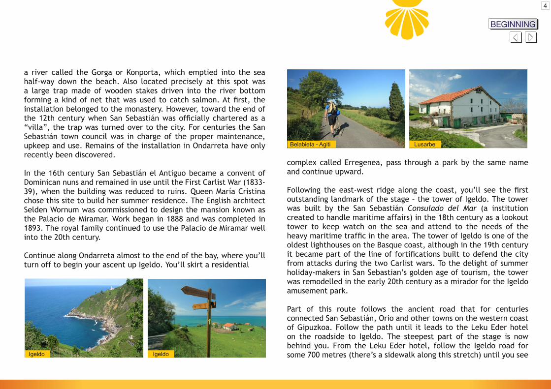
a river called the Gorga or Konporta, which emptied into the sea half-way down the beach. Also located precisely at this spot was a large trap made of wooden stakes driven into the river bottom forming a kind of net that was used to catch salmon. At first, the installation belonged to the monastery. However, toward the end of the 12th century when San Sebastián was officially chartered as a “villa”, the trap was turned over to the city. For centuries the San Sebastián town council was in charge of the proper maintenance, upkeep and use. Remains of the installation in Ondarreta have only recently been discovered.
In the 16th century San Sebastián el Antiguo became a convent of Dominican nuns and remained in use until the First Carlist War (1833-39), when the building was reduced to ruins. Queen María Cristina chose this site to build her summer residence. The English architect Selden Wornum was commissioned to design the mansion known as the Palacio de Miramar. Work began in 1888 and was completed in 1893. The royal family continued to use the Palacio de Miramar well into the 20th century.
Continue along Ondarreta almost to the end of the bay, where you’ll turn off to begin your ascent up Igeldo. You’ll skirt a residential
Belabieta - Agiti Lusarbe
Igeldo Igeldo
complex called Erregenea, pass through a park by the same name and continue upward.
Following the east-west ridge along the coast, you’ll see the first outstanding landmark of the stage – the tower of Igeldo. The tower was built by the San Sebastián Consulado del Mar (a institution created to handle maritime affairs) in the 18th century as a lookout tower to keep watch on the sea and attend to the needs of the heavy maritime traffic in the area. The tower of Igeldo is one of the oldest lighthouses on the Basque coast, although in the 19th century it became part of the line of fortifications built to defend the city from attacks during the two Carlist wars. To the delight of summer holiday-makers in San Sebastian’s golden age of tourism, the tower was remodelled in the early 20th century as a mirador for the Igeldo amusement park.
Part of this route follows the ancient road that for centuries connected San Sebastián, Orio and other towns on the western coast of Gipuzkoa. Follow the path until it leads to the Leku Eder hotel on the roadside to Igeldo. The steepest part of the stage is now behind you. From the Leku Eder hotel, follow the Igeldo road forsome 700 metres (there’s a sidewalk along this stretch) until you see
4
BEGINNINGMapa delrecorrido
Mapa delrecorrido
Aganduru San Martin
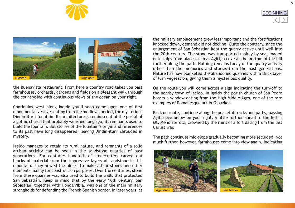
the military emplacement grew less important and the fortifications knocked down, demand did not decline. Quite the contrary, since the enlargement of San Sebastian kept the quarry active until well into the 20th century. The stone was transported mainly by sea, loaded onto ships from places such as Agiti, a cove at the bottom of the hill further along the path. Nothing remains today of the quarry activity other than the memories and stories from the past generations. Nature has now blanketed the abandoned quarries with a thick layer of lush vegetation, giving them a mysterious quality.
On the route you will come across a sign indicating the turn-off to the nearby town of Igeldo. In Igeldo the parish church of San Pedro boasts a window dating from the High Middle Ages, one of the rare examples of Romanesque art in Gipuzkoa.
Back on route, continue along the peaceful tracks and paths, passing Agiti cove below on your right. A little further ahead to the left is Mt. Mendizorrotz, crowned by the ruins of a fort dating from the last Carlist war.
The path continues mid-slope gradually becoming more secluded. Not much further, however, farmhouses come into view again, indicating
the Buenavista restaurant. From here a country road takes you past farmhouses, orchards, gardens and fields on a pleasant walk through the countryside with continuous views of the ocean on your right.
Continuing west along Igeldo you’ll soon come upon one of first monumental vestiges dating from the medieval period, the mysterious Dindin-iturri fountain. Its architecture is reminiscent of the portal of a gothic church that probably vanished long ago, its remnants used to build the fountain. But stories of the fountain’s origin and references to its past have long disappeared, leaving Dindin-iturri shrouded in mystery.
Igeldo manages to retain its rural nature, and remnants of a solid artisan activity can be seen in the sandstone quarries of past generations. For centuries hundreds of stonecutters carved out blocks of material from the impressive layers of sandstone in thismountain. They hewed the blocks to make ashlar stones and other elements mainly for construction purposes. Over the centuries, stone from these quarries was also used to build the walls that protected San Sebastián. Keep in mind that by the early 16th century, San Sebastián, together with Hondarribia, was one of the main military strongholds for defending the French-Spanish border. In later years, as
Lusarbe Munioeta
5
BEGINNINGMapa delrecorrido
Mapa delrecorrido

San Martin Orio - Stations of the Cross
the municipal limits of Orio. Some of the farmhouses, such as Lusarbe, Munioeta and Aganduru, date as far back as the 12th century. In a short distance you’ll turn inland from the small chain of coastal hills and pass the nearby Ventas de Orio. The word ‘ventas’ (sales) hearkens back to the place where travellers could find food and lodging, and where merchants traded in different types of goods and merchandise. A farmhouse called Benta (‘venta’) still pays tribute to the innkeeping tradition, and continues to be a popular local restaurant.
Now you are down into the lower basin of the Oria River, the biggest and longest river in Gipuzkoa. The Oria flows south to north through most of inland Gipuzkoa, and then takes a sudden change of directionat the foot of Igeldo. At this point the river runs parallel to the sea and the coastal range you’ve just left behind, forming wide meanders as it snakes its way to the sea. This stretch affords fabulous views over the lower Oria river valley.
The route follows the Orio road for a short while and then drops steeply down along one of the best-preserved sections of the coastal route to a farmhouse called Aganduru. A witness to the long history
San Martin Orio - Aia
6
of this road, the earliest mention of Aganduru appears in a document dating to the 12th century, in which Aganduru is listed as one of the properties located between Igeldo and Orio donated by the king of Pamplona, García V The Restorer to the great Navarrese monastery San Salvador de Leire.
Leaving the Aganduru farmhouse behind, you now follow a paved road down to a small valley called the Txanka. After passing underneath the A-8 motorway, the trail heads up to the right. A short climb takes you to the ancient chapel of San Martin de Tours, patron saint of travellers and pilgrims. This beautiful shrine is located on a picturesque hilltop overlooking the mouth of the Oria River as it flows to the sea.
Following the Via Crucis, or Stations of the Cross, on what was once the main road leading from San Sebastián to Orio, you’ll come to a series of beautiful 16th century buildings designed with a clearly marine influence. You’re now entering the Orio’s medieval centre along Kale Nagusia (Main Street), lined with a number of ancestral homes. At the upper end of the street on your right is what remains
BEGINNINGMapa delrecorrido
Mapa delrecorrido
OrioSan Nikolas
San NikolasMain Street
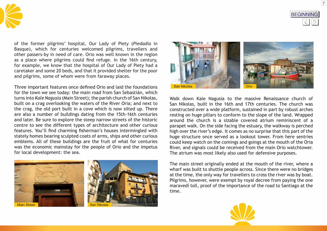
Walk down Kale Nagusia to the massive Renaissance church of San Nikolas, built in the 16th and 17th centuries. The church was constructed over a wide platform, sustained in part by robust arches resting on huge pillars to conform to the slope of the land. Wrapped around the church is a sizable covered atrium reminiscent of a parapet walk. On the side facing the estuary, the walkway is perched high over the river’s edge. It comes as no surprise that this part of the huge structure once served as a lookout tower. From here sentries could keep watch on the comings and goings at the mouth of the Oria River, and signals could be received from the main Orio watchtower. The atrium was most likely also used for defensive purposes.
The main street originally ended at the mouth of the river, where a wharf was built to shuttle people across. Since there were no bridges at the time, the only way for travellers to cross the river was by boat. Pilgrims, however, were exempt by royal decree from paying the one maravedí toll, proof of the importance of the road to Santiago at the time.
of the former pilgrims’ hospital, Our Lady of Piety (Piedadia in Basque), which for centuries welcomed pilgrims, travellers and other passers-by in need of care. Orio was well known in the region as a place where pilgrims could find refuge. In the 16th century, for example, we know that the hospital of Our Lady of Piety had a caretaker and some 20 beds, and that it provided shelter for the poor and pilgrims, some of whom were from faraway places.
Three important features once defined Orio and laid the foundations for the town we see today: the main road from San Sebastián, which turns into Kale Nagusia (Main Street); the parish church of San Nikolas, built on a crag overlooking the waters of the River Oria; and next to the crag, the old port built in a cove which is now silted up. There are also a number of buildings dating from the 15th-16th centuries and later. Be sure to explore the steep narrow streets of the historic centre to see the different types of architecture and other curious features. You’ll find charming fisherman’s houses intermingled with stately homes bearing sculpted coats of arms, ships and other curious emblems. All of these buildings are the fruit of what for centuries was the economic mainstay for the people of Orio and the impetus for local development: the sea.
7
BEGINNINGMapa delrecorrido
Mapa delrecorrido

8
PILGRIM’SHOSTELArteta EtxeaBarrio San MartinTel.: 617 11 86 89E-mail: [email protected]
TOURIST OFFICE
Kale Nagusia, 1720810 OrioTel./Fax: 943 830 904E-mail: [email protected]
ST JAMES WAYINTERPRETATION CENTRE
Kale nagusia, 17 - 20810 OrioTel./Fax: 943 830 904E-mail: [email protected]
ORIOO
RIO Mapa del
recorridoAll
accommodationMapa delrecorridoRestaurants
BEGINNINGMapa delrecorrido
Chemin de Saint-Jacques par la côte
GIPUZKOA - UROLA KOSTA
Mapa delrecorrido
Plan de l’itinéraire
Mapa delrecorrido
Profil de l’étape
Mapa delrecorridoDescription
de l’itinéraireMapa delrecorrido
Mapa delrecorrido
Tous les hébergements
Office de tourisme
Mapa delrecorridoRestaurantsMapa del
recorridoAuberge de
pèlerins
Zarautz Getaria Zumaia Deba Orio San Sebastián
ÉTAPE
Donostia

DÉBUTMapa delrecorrido
Mapa delrecorrido
1
Plan 1 Orio San Sebastián
ÉTAPE
Donostia
Plan 2Mapa delrecorrido
2
Plan 2 Orio San Sebastián
ÉTAPE
Donostia
Plan 1Mapa delrecorrido
DÉBUTMapa delrecorrido
Mapa delrecorrido
La Concha Donostia / San Sebastián
Alderdi Eder Miramar
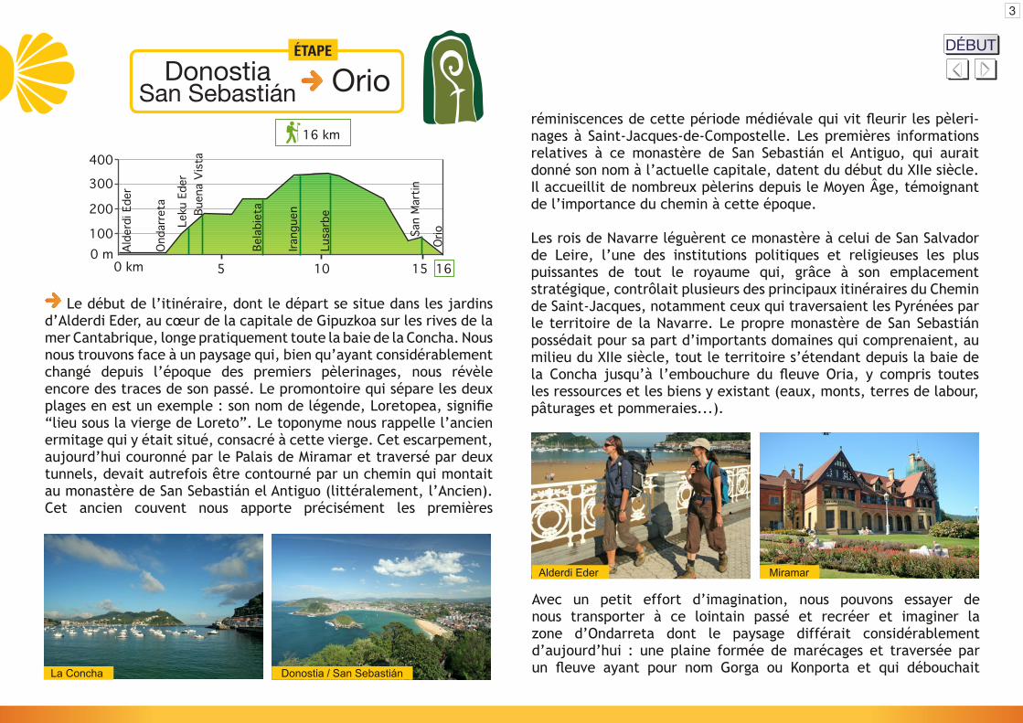
Le début de l’itinéraire, dont le départ se situe dans les jardins d’Alderdi Eder, au cœur de la capitale de Gipuzkoa sur les rives de la mer Cantabrique, longe pratiquement toute la baie de la Concha. Nous nous trouvons face à un paysage qui, bien qu’ayant considérablement changé depuis l’époque des premiers pèlerinages, nous révèle encore des traces de son passé. Le promontoire qui sépare les deux plages en est un exemple : son nom de légende, Loretopea, signifie “lieu sous la vierge de Loreto”. Le toponyme nous rappelle l’ancien ermitage qui y était situé, consacré à cette vierge. Cet escarpement, aujourd’hui couronné par le Palais de Miramar et traversé par deux tunnels, devait autrefois être contourné par un chemin qui montait au monastère de San Sebastián el Antiguo (littéralement, l’Ancien). Cet ancien couvent nous apporte précisément les premières
Avec un petit effort d’imagination, nous pouvons essayer de nous transporter à ce lointain passé et recréer et imaginer la zone d’Ondarreta dont le paysage différait considérablement d’aujourd’hui : une plaine formée de marécages et traversée parun fleuve ayant pour nom Gorga ou Konporta et qui débouchait
3
réminiscences de cette période médiévale qui vit fleurir les pèleri-nages à Saint-Jacques-de-Compostelle. Les premières informations relatives à ce monastère de San Sebastián el Antiguo, qui aurait donné son nom à l’actuelle capitale, datent du début du XIIe siècle. Il accueillit de nombreux pèlerins depuis le Moyen Âge, témoignant de l’importance du chemin à cette époque.
Les rois de Navarre léguèrent ce monastère à celui de San Salvador de Leire, l’une des institutions politiques et religieuses les plus puissantes de tout le royaume qui, grâce à son emplacement stratégique, contrôlait plusieurs des principaux itinéraires du Chemin de Saint-Jacques, notamment ceux qui traversaient les Pyrénées par le territoire de la Navarre. Le propre monastère de San Sebastián possédait pour sa part d’importants domaines qui comprenaient, au milieu du XIIe siècle, tout le territoire s’étendant depuis la baie de la Concha jusqu’à l’embouchure du fleuve Oria, y compris toutes les ressources et les biens y existant (eaux, monts, terres de labour, pâturages et pommeraies...).
0 km0 m100
200
300
400
15 16105
Alde
rdi E
der
Onda
rret
a
Leku
Ede
rBu
ena
Vist
a
Bela
biet
a
OrioSa
n M
artin
Lusa
rbe
Irang
uen
16 km
Orio San Sebastián
ÉTAPE
Donostia DÉBUT
Mapa delrecorrido
Mapa delrecorrido

au centre de la plage actuelle. À cet endroit précis se trouvait également une importante nasse, structure de piquets en bois plantés dans le fond du lit en guise de filet pour pêcher les saumons. Ces installations appartinrent dans un premier temps au monastère puis furent incorporées aux possessions de la ville de San Sebastián, lorsque celle-ci fut fondée comme cité. Désormais, ce serait le conseil ou municipalité de la cité de San Sebastián qui, durant des siècles, serait chargé de réparer et de garder en état d’exploitation la nasse d’Ondarreta, dont les restes ont été découverts récemment.
Le monastère fut dès le XVIe siècle couvent de Dominicaines, une fonction qu’il remplit jusqu’à sa destruction durant la Première Guerre Carliste (1833-39). Finalement, l’emplacement où gisaient les ruines de l’ancien couvent fut choisi par la Reine María Cristina pour y construire sa résidence d’été, le Palais de Miramar. Le projet de l’édifice fut commandé à l’architecte anglais Selden Wornum et l’édifice lui-même fut érigé entre 1888 et 1893. La famille royale continua d’utiliser le Palais durant une bonne partie du XXe siècle.
En poursuivant par Ondarreta, avec la baie derrière nous, le chemin commence à monter sur le versant du mont Igeldo. Nous longerons d’abord le complexe résidentiel d’Erregenea puis nous monterons à travers le parc du même nom au mont Igeldo.
Belabieta - Agiti Lusarbe
Igeldo Igeldo
Dans la partie finale de la chaîne côtière qui commence ici, la tour d’Igeldo constitue l’une des premières haltes : cette tour témoigne d’un passé où la surveillance de la mer était d’une importance vitale. Elle fut construite par le « Consulado » (corporation maritime et commerciale) de San Sebastián au XVIIIe siècle pour satisfaire les besoins générés par l’intense trafic naval qui caractérisait la ville. C’est ainsi l’un des plus anciens phares de la côte basque même si, pendant les deux guerres civiles du XIXe siècle, elle fut incorporée à l’ensemble des fortifications construites pour défendre la ville des attaques carlistes. Finalement, au début du XXe siècle, elle fut réaménagée comme mirador du parc d’attractions d’Igeldo, faisant ainsi, avec ses vues imprenables, les délices des estivants de l’époque dorée du tourisme à San Sebastián.
Une partie de cet itinéraire suit l’ancien chemin qui relia pendant des siècles la ville de San Sebastián à Orio et au reste des localités côtières de l’ouest de Gipuzkoa. Le sentier que nous avons emprunté nous conduit jusqu’à l’hôtel Leku Eder, situé au bord de la route qui accède à Igeldo. Une fois surmonté le premier et principal raidillon du parcours, on continue depuis l’hôtel Leku Eder par le trottoir qui longe la route d’Igeldo, pendant environ 700 mètres, jusqu’au restaurant Buenavista. Au pied de ce dernier, un petit chemin vicinal se faufile à mi-versant entre villas, fermes, potagers et prairies, en une agréable et belle promenade avec vue sur la mer.
4
DÉBUTMapa delrecorrido
Mapa delrecorrido

Aganduru San Martin
une bonne partie du XXe siècle. La pierre était principalement transportée par voie maritime et chargée dans des embarcadères situés par exemple dans la cale d’Agiti, au pied du chemin que nous empruntons. Actuellement, il ne reste rien de cette activité, hormis les mémoires des anciennes générations et les grandes carrières abandonnées, déjà envahies par la végétation, une conquête de la nature qui leur confère une aura de mystère et de séduction.
Sur notre chemin, nous trouverons un signal qui nous indique la bifurcation vers le village d’Igeldo, à proximité. Son église, consacrée à San Pedro, contient quelques-unes des rares manifestations de style roman conservées dans la province de Gipuzkoa, comme une grande baie du Haut Moyen Âge.
De retour sur notre chemin de Saint-Jacques, nous continuerons de progresser le long de pistes et de chemins commodes jusqu’à nous situer d’abord à hauteur de la cale d’Agiti mentionnée plus haut, puis sous la cime du mont Mendizorrotz, un mont couronné des ruines d’un fort de la dernière guerre carliste.
Le chemin poursuit sa route à mi-versant et acquiert ainsi progressivement un caractère plus solitaire, même si très rapidement,en avançant sur des pistes agréables, la présence de plusieurs fermes nous indiquera l’entrée dans la commune d’Orio. Certaines de ces
En poursuivant notre chemin vers l’ouest, nous découvrirons rapidement un des premiers monuments et vestige de l’époque médiévale qui subsistent à Igeldo, la mystérieuse fontaine de Dindin-iturri. Son architecture évoque l’image du portique d’un temple gothique disparu il y a bien longtemps, des vestiges qui auraient pu être utilisés pour la fontaine. Néanmoins, les histoires relatives à son origine et aux événements qui ont marqué son passé ont été perdues depuis longtemps et le mystère de Dindin-iturri demeure.
Igeldo est un site qui conserve son caractère rural en même temps que des traces d’une activité artisanale autrefois florissante : l’exploitation de ses carrières de pierre de taille. Durant des siècles, une infinité de carriers s’acharnèrent à extraire de gros blocs de pierre de ce mont, qui une fois taillés étaient pour la plupart destinés à la construction d’édifices. C’est de là par exemple que furent extraites au fil des siècles les gigantesques quantités de pierre nécessaires à la construction des fortifications de San Sebastián. Il ne faut pas oublier que déjà au début du XVIe siècle, San Sebastián s’était érigée, avec Hondarribia-Fontarabie, en l’une des principales places fortes militaires qui défendaient la frontière franco-espagnole. À une époque plus récente, la perte de valeur militaire de la place et la démolition des fortifications n’entraîna pas une réduction de la demande, bien au contraire, puisque la construction de l’agrandissement de la ville de San Sebastián favorisa l’exploitation des carrières durant
Lusarbe Munioeta
5
DÉBUTMapa delrecorrido
Mapa delrecorrido

San Martin Orio - Via Crucis
San Martin Orio - Aia
6
DÉBUTMapa delrecorrido
Mapa delrecorrido
fermes, comme par exemple Lusarbe, Munioeta ou Aganduru, sont très anciennes puisqu’on les cite déjà au XIIe siècle. Nous traverserons bientôt la chaîne côtière vers l’intérieur et nous passerons près de Ventas de Orio, un nom qui provient des anciennes installations qui prêtaient assistance aux voyageurs pour se loger et se nourrir, et servaient d’infrastructures à tous types d’échanges commerciaux. La ferme Benta, un bar-restaurant encore très fréquenté, demeure fidèle à la tradition.
Nous pénétrons ainsi dans la basse vallée du fleuve Oria, le fleuve le plus long et à plus haut débit de Gipuzkoa. L’Oria, après avoir parcouru dans le sens sud-nord une partie importante de l’intérieur du territoire de Gipuzkoa, change radicalement de direction en arrivant au pied du mont Igeldo pour évoluer désormais parallèlement à la mer et à la chaîne côtière que nous empruntons, en décrivant de grands méandres dans son périple inexorable vers l’embouchure proche. Ce trajet nous régale avec des vues magnifiques sur toute la basse vallée de l’Oria.
Après un bref tronçon par la route et en descendant vers Orio, commence l’une des sections de la chaussée les mieux conservées du Chemin. La chaussée descend ainsi en pente prononcée jusqu’à la ferme Aganduru. Cette ferme est citée pour la première fois au XIIe siècle dans une description des propriétés situées entre Igeldo
et Orio, léguées par le roi de Pampelune Garcia V le Restaurateur au grand monastère de San Salvador de Leire de Navarre, ce qui nous donne une idée de l’ancienneté de la chaussée que nous empruntons.
Nous laissons derrière nous la ferme Aganduru et nous poursuivons par une piste goudronnée jusqu’au fond de la petite vallée de la rivière Txanka. Là, nous passons sous le pont de l’autoroute A-8 et nous continuons par la côte qui monte à droite. Après ce petit raidillon, nous atteindrons le bel et très ancien ermitage de Saint Martin de Tours, patron des voyageurs et des pèlerins. Ce bel ermitage est situé à un emplacement privilégié, au sommet d’une colline avec des vues sur l’embouchure de l’Oria, dans l’antichambre du quartier historique d’Orio.
En suivant le chemin de croix qui jalonne le chemin, autrefois chemin principal qui unissait Orio et San Sebastián, nous rencontrerons de magnifiques édifices du XVIe siècle, construits dans un style clairement marin. Nous pénètrerons ainsi dans le centre médiéval de la localité à travers la rue principale d’Orio, Kale Nagusia ou “Grande Rue”, jalonnée de nombreuses maisons nobles et de caractère. Au tout début de la rue, nous avons sur notre droite les restes de l’ancien hôpital. Cet édifice, consacré à Notre-Dame de Pitié, accueillit durant des siècles les pèlerins, voyageurs et autres passants cherchant

OrioSan Nikolas
San NikolasGrande Rue
partie par de puissants arcs qui reposent sur de gros piliers, pour s’adapter à la pente du terrain. L’église est entourée d’un grand atrium entièrement couvert sur tout son périmètre, en guise de chemin de ronde ; la partie qui donne sur la ria et son estuaire se trouve à une grande hauteur au-dessus du niveau de la rive. Il n’est pas étonnant qu’une partie de cette grande structure ait servi de poste de guet, permettant l’observation de tout ce qui se passait dans l’estuaire de l’Oria et la réception des signaux émis depuis le principal poste de guet d’Orio, ou ait aussi satisfait à des fonctions défensives.
La rue principale débouchait initialement dans l’estuaire, où il existait un embarcadère avec un service de passage mis à la disposition des passants par la ville d’Orio. La barque destinée au transbordement était le seul moyen de joindre les deux rives et à défaut de pont, les voyageurs n’avaient d’autre remède que de louer ses services pour atteindre l’autre rive de l’estuaire. Néanmoins, les pèlerins bénéficiaient d’un privilège royal qui les exemptait du paiement du prix de la traversée, un « maravedi », ce qui reflète bien l’importance du chemin de Saint-Jacques à cette époque.
assistance, suivant la tradition d’accueil qui était propre à Orio. Au XVIe siècle par exemple, cet ancien hôpital de la Piété ou Piedadia comptait un surveillant et une vingtaine de lits et accueillait aussi bien les pauvres que les pèlerins, dont certains venus de très loin.
Le tracé urbain de la localité d’Orio est le résultat de l’union de trois éléments capitaux en une seule structure urbaine : le chemin principal provenant de San Sebastián, qui se prolonge par la Kale Nagusia; l’église San Nikolas, érigée sur un rocher surplombant les eaux de l’Oria; et le vieux port, qui était situé dans une cale, aujourd’hui colmatée, près de ce rocher. L’enceinte originale de la cité d’Orio conserve par ailleurs divers édifices des XVe et XVIe siècles et postérieurs. Il est intéressant de parcourir les rues raides et étroites du vieux quartier pour admirer tous ces éléments urbanistiques et architecturaux : ça et là se dressent de belles maisons de pêcheurs et d’élégants hôtels particuliers, avec leurs blasons d’armes, des représentations d’embarcations et beaucoup d’autres éléments singuliers. Tous ces éléments sont le fruit de ce qui constitua durant des siècles la principale ressource économique et la source de développement des habitants de la ville : les activités rattachées à la mer.
En descendant par la Kale Nagusia, nous atteindrons l’église San Nikolas, un énorme édifice de style Renaissance des XVIe et XVIIe siècle. Elle est construite sur une grande plateforme, soutenue en
7
DÉBUTMapa delrecorrido
Mapa delrecorrido
8
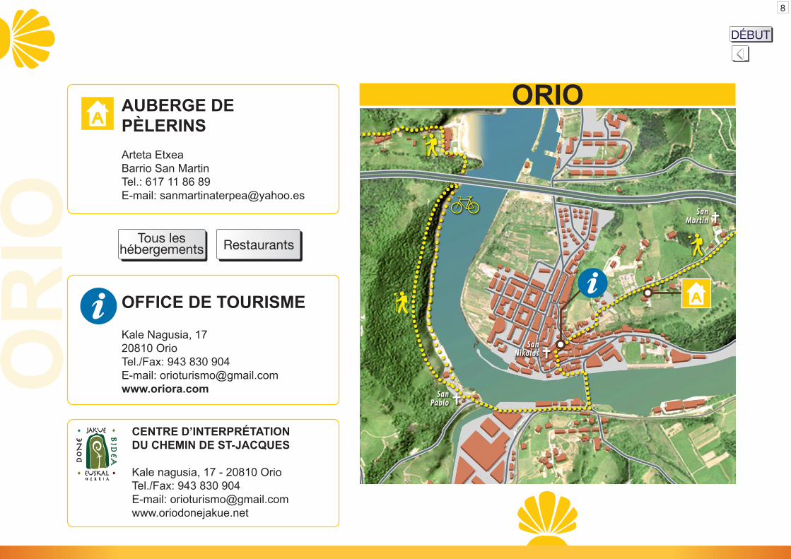
AUBERGE DEPÈLERINSArteta EtxeaBarrio San MartinTel.: 617 11 86 89E-mail: [email protected]
OFFICE DE TOURISME
Kale Nagusia, 1720810 OrioTel./Fax: 943 830 904E-mail: [email protected]
CENTRE D’INTERPRÉTATIONDU CHEMIN DE ST-JACQUES
Kale nagusia, 17 - 20810 OrioTel./Fax: 943 830 904E-mail: [email protected]
ORIOO
RIO Mapa del
recorridoTous les
hébergementsMapa delrecorridoRestaurants
DÉBUTMapa delrecorrido