DATA SHEET · 2018-07-05 · Motor de procesamiento de imágenes GPU, CPU Conectores ráster...
12
DATA SHEET
-
Upload
vuongkhanh -
Category
Documents
-
view
213 -
download
0
Transcript of DATA SHEET · 2018-07-05 · Motor de procesamiento de imágenes GPU, CPU Conectores ráster...

D A T A S H E E T

DATA SHEET/V2018.0SERVER
LuciadFusion
LuciadFusion is an all-in-one server solution for your data publication workflow and geospatial data management. As Luciad’s server solution, it allows users to manage their data intelligently, store and process a multitude of data formats and feed data to numerous applications. V2018 of LuciadFusion brings an enormous new feature set that puts the power of your data at your fingertips. Features including powerful automatic cataloging, as well as quick and easy data publishing allow you to design, portray, process and set up advanced maps in a few simple clicks.
It offers intuitive data management for non-GIS specialists and faster data processing than with any other commercial solution. It allows you to organize your data so that all users have one-click access to a data set specifically optimized for their needs.
Connecting directly to more than 200 data formats, the ready-to-use server solution installs quickly to start processing large volumes of data, fetching regular updates and publishing an impressive number of data formats. LuciadFusion Studio is a new browser application that provides you with a friendly user interface with an integrated data preview that allows you to publish data in a few clicks.
WHO NEEDS LUCIAD’S SERVER SOLUTION?
These are just a few examples of why users turn to LuciadFusion for their geospatial data challenges:
• You have large amounts of geospatial data and you need to publish it quickly in OGC standard formats with just a few clicks.
• You are receiving new images every hour and you want to eliminate the delay for publication.
• You have ECDIS Maritime data that needs to be shared using the OGC Services without hassle.
• You have received a DVD with raster and vector data in many different formats (Shape, KML, GeoTiff) and you want to visualize and share them in a matter of minutes.
• You have to visualize weather data with temporal information and want to quickly browse through time.
• 3D is critical for you and you want to use the latest elevation data in high resolution.
• You have multi-gigabyte shape files that you want to share as WMS but you do not want to rasterize it before publishing.
• You want to bring line of sight calculations to a web-based application.
2

BUILT FOR USERS • Publish data in one click to any service • Quickly upload, find and publish data through LuciadFusion Studio’s
intuitive web interface • Fastest and most user friendly OGC service platform to install, create
services and serve data • Serve maps faster with the quickest tiling engine for elevation,
(multispectral) imagery, weather data and more
CONNECT TO 200+ DATA FORMATS
• Connect to any database • Work with domain-specific formats and standards
• Weather • Aviation • Defense • Maritime
• Directly serve earth observation multi-spectral imagery • Handle dynamic 4D data such as weather data • Include military symbology APP6 and MS2525 • Combine vector and raster in one single product • Connect natively to 200+ data formats and add custom formats through
LuciadFusion’s API
KEY BENEFITS
METADATACATALOG
_LUCIADFUSION PLATFORM
CATALOG &CRAWL
VISUALIZE ANALYZE TILE PUBLISH
OGCSERVICES
CSW, WMS, WFS, WCS, WMTS & WPS
EASY DATA MANAGEMENTVIA THE BROWSER
_LUCIADFUSIONSTUDIO
ANY DATA SOURCE, IN ITS ORIGINAL FORMAT
CUSTOMSERVICES
ANALYTICS,EXPORT & MORE
SYMBOLOGYSERVICES
NATO, MARITIME& MORE
3DSERVICES
UNLIMITED TERRAIN, REALITY MESHES,
POINT CLOUDS
Figure 1 - With Luciad, manage, visualize, analyze and publish data its original format on any platform.
3
DATA SHEET/V2018.0SERVER
LuciadFusion
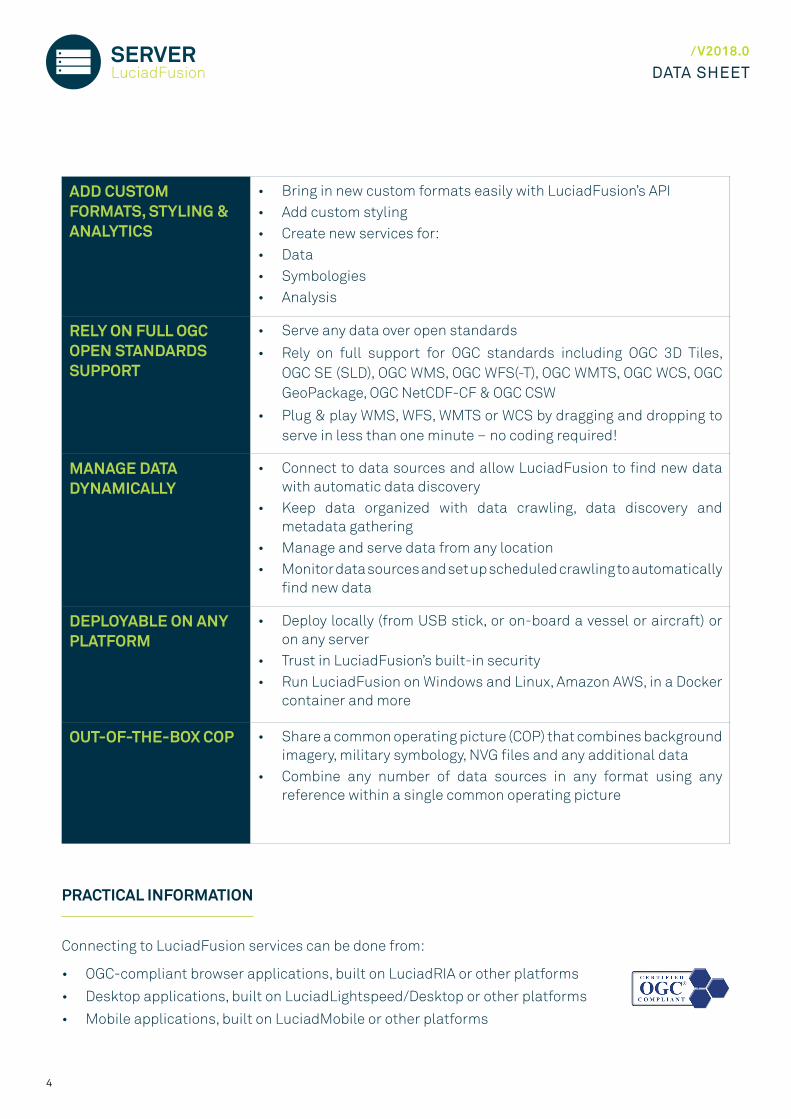
ADD CUSTOM FORMATS, STYLING & ANALYTICS
• Bring in new custom formats easily with LuciadFusion’s API • Add custom styling • Create new services for: • Data • Symbologies • Analysis
RELY ON FULL OGC OPEN STANDARDS SUPPORT
• Serve any data over open standards
• Rely on full support for OGC standards including OGC 3D Tiles, OGC SE (SLD), OGC WMS, OGC WFS(-T), OGC WMTS, OGC WCS, OGC GeoPackage, OGC NetCDF-CF & OGC CSW
• Plug & play WMS, WFS, WMTS or WCS by dragging and dropping to serve in less than one minute − no coding required!
MANAGE DATA DYNAMICALLY
• Connect to data sources and allow LuciadFusion to find new data with automatic data discovery
• Keep data organized with data crawling, data discovery and metadata gathering
• Manage and serve data from any location • Monitor data sources and set up scheduled crawling to automatically
find new data
DEPLOYABLE ON ANY PLATFORM
• Deploy locally (from USB stick, or on-board a vessel or aircraft) or on any server
• Trust in LuciadFusion’s built-in security • Run LuciadFusion on Windows and Linux, Amazon AWS, in a Docker
container and more
OUT-OF-THE-BOX COP • Share a common operating picture (COP) that combines background imagery, military symbology, NVG files and any additional data
• Combine any number of data sources in any format using any reference within a single common operating picture
PRACTICAL INFORMATION
Connecting to LuciadFusion services can be done from:
• OGC-compliant browser applications, built on LuciadRIA or other platforms
• Desktop applications, built on LuciadLightspeed/Desktop or other platforms
• Mobile applications, built on LuciadMobile or other platforms
4

OVERVIEW
The LuciadFusion options are organized into product tiers. Depending on the needs of your organization, you can opt for LuciadFusion Essential, Advanced or Pro. From the Advanced and Pro tiers, powerful, extended functionality is available to you with extra options.
DESKTOPLuciadLightspeed
FUNCIONALIDAD
Motor GIS central
Modelos de proyección, datum y geoide
Motor de proyección y transformación
Modelo de geometría geodésica y cartesiana 4D
Modelo de datos unificados
Simbología personalizable
Motor de procesamiento de imágenes GPU, CPU
Conectores ráster
Conectores vectoriales
Estándares OGC
Servicios OGC
Servicio de "tile"
Motor de "tiling"
Servicios de simbología
Gestión de datos y catálogo
Rastreo de datos y recolección de metadatos
Plataforma de servicio Web Extensible
Motor GIS Avanzado
Motor de tiempo real
Conectores avanzados de ráster
Conectores de bases de datos
Motor de análisis de terreno
Estándares de tiempo y medio ambiente
Motor de enrutamiento y grafos
Conectores de CAD
Conectores de radar
Estándares de aviación
Estándares de defensa
Simbología de defensa
Estándares marítimos
S-63
ESSENTIAL ADVANCED PRO
Feature included Optional feature Feature unavailable
5
FUNCTIONALITY
Core GIS Engine
Projection, Datum & Geoid Models
Transformation and Projection Engine
4D Cartesian & Geodesic Geometry Model
Unified Data Model
Customizable Symbology
CPU, GPU Image Processing Engine
Raster Connectors
Vector Connectors
Point Clouds & Reality Meshes
OGC Standards
OGC Services
Tiled Services
Tiling Engine
Symbology Services
Data Management & Catalog
Data Crawling & Metadata harvesting
Extensible Web Service Platform
Advanced GIS Engine
Real-time Engine
Advanced Raster Connectors
Database Connectors
Terrain Analysis Engine
Weather & Environment Standards
Graph & Routing Engine
CAD Connectors
Radar Connectors
Aviation Standards
Defense Standards
Defense Symbology
Maritime Standards
S-63
ESSENTIAL ADVANCED PRO

DATA SHEET/V2018.0SERVER
LuciadFusion
E Included in Essential A Included in Advanced P Included in Pro
FUNCTIONAL SPECIFICATION
Below is a high-level, non-exhaustive overview of the functionality available in LuciadFusion. You can use the functionality it offers out-of-the-box or extend it to meet user specific requirements.
- CORE GIS ENGINE- PROJECTION, DATUM & GEOID MODELS- TRANSFORMATION & PROJECTION ENGINE
• Access and represent data in any coordinate reference system (geodetic, geocentric, topocentric, grid) and in any projection.
• Perform advanced geodetic calculations, transformations, and ortho-rectification.
• On-the-fly serving, fusion, and tiling of data in any coordinate reference. Accurate and correct warping of both vector and raster data.
- 4D CARTESIAN & GEODESIC GEOMETRY MODEL- UNIFIED DATA MODEL
• Model any data format regardless of size, represent all object geometries and their metadata, and apply any data filter.
• Includes support for complex geometries like geo-buffers, arcs and arc bands, radar coverage areas, and so on.
• Accurately visualize radar coverage beams and other sensor detection ranges as 3D volumes, and set up geofencing for those volumes.
- CUSTOMIZABLE SYMBOLOGY
• Apply flexible styling (layers, icons, line styles, fill styles, transparency...) to your data and customize it using the OGC-defined Styled Layer Descriptor/Symbology Encoding (SLD/SE) standards through the LuciadFusion Studio. This includes both vector and raster data.
• Extend SLD or implement and plugin custom layer factories to do advanced styling using for example density plots and heat maps.
• Include processing in your styling such as extracting contours from raster data before styling using fill and line styles.
• Advanced labeling of vector data including on-path labeling.
- CPU, GPU IMAGE PROCESSING ENGINE
• Advanced, high-performance processing and rendering of raster data, including High Dynamic Range (HDR) and multi-spectral imagery.
• Apply image processing chains using a complete set of image algebra operators that can be applied to any raster imagery (including weather data, multi-spectral data), before serving the data over OGC services, or before exporting data for example to OGC GeoPackage.
• High-performance accelerated OpenCL implementation for multi-core servers or GPU accelerated servers with automatic fallback to a high-performance multi-threaded CPU implementation.
- RASTER CONNECTORS- VECTOR CONNECTORS
• Access and serve data straight from the source in many vector and raster formats. Apply multi-leveling and tiling on any data source.
• All visualization, analysis, and serving capabilities are data-agnostic, so it is complementary with any data format. Adding support for new, custom formats is a straightforward, well-documented process, but most common data formats are already supported.Out-of-the box native support for:
• Raster data: BIL, Bing Maps, BMP, DTED, ESRI TFW and JGW, ETOPO, GeoTIFF and BigTIFF, GIF, JPEG, JPEG2000, MapInfo TAB, PNG, PPM, USGS DEM.
• Vector data: CGM, Collada, ESRI Shape, GeoJSON, MapInfo MIF & MAP, LIDAR LASer and LASZip (LAZ), OpenFlight (3-D), OGC 3D tiles, OSGB 3D meshes, SVG, Wavefront OBJ (3-D).
E A P
E A P
E A P
E A P
E A P
6

- POINT CLOUDS- REALITY MESHES
• Connect to, visualize and serve unlimited point clouds and reality meshes. • Stream as OGC 3D Tiles. • Serve reality meshes on-the-fly, directly from the source. • Tile and multi-level point clouds efficiently for optimal serving.
Out-of-the-box native support for:OSGB, LAS, LAZ, OGC 3D Tiles
- OGC STANDARDS • Connect to several OGC web services, and read data in several OGC formats.
Standards, formats, and services:OGC CSW, GeoPackage, GML, KML, WCS, WFS(-T), WMS, WMTS, OGC Filter 2.0 (Spatial filter capabilities can be enabled from the Advanced GIS Engine listed under Advanced and Pro options), OGC Symbology Encoding (SE), ISO 19115 metadata.
- OGC SERVICES • Serve any data via OGC services on the fly, directly from the source. Configure several OGC web service end points, and let them monitor data updates. Plug in support for your own custom data or styling.
• Easy-to-use web frontend to manage data, metadata, styles, products, and publish services.
• Support for on-the-fly WMTS for any data source as well as WMTS from pre-tiled data sets.
• Support for on-the-fly 3D tiles for OSGB mesh data sources as well as processed LAS/LAZ data.OGC services:OG WMS, WCS, WFS(-T), WMTS, CSW, 3D Tiles
- TILED SERVICES • Serve pre-tiled data via Luciad Tile Services (LTS) for optimal performance. Using LTS, you can send multi-dimensional or elevation data tiles for client-side analysis.
• Turn unwieldy point clouds into highly efficient multi-level tile pyramids through the integrated processing capabilities for LIDAR LAS/LAZ files.
- TILING ENGINE • Fuse, tile, and multi-level large amounts of data using the tiling engine. • Build globes with detailed and accurate point-sampled terrain data,
centimeter-accurate area-sampled (multispectral) imagery, and multi-dimensional weather data and imagery.
- SYMBOLOGY SERVICES • Use a service to provide full sets of Defense Symbology icons with icon styling specifications. Use the same icons across the system, on the map and in other (UI) components. Requires the Defense Symbology Option. Symbology standards/format:APP-6A, APP-6B, APP-6C, MS2525b, MS2525c, TTA-106
- DATA MANAGEMENT & CATALOG
• Centrally organize, manage and serve all your geospatial data and styles from the LuciadFusion Studio web application, regardless of the format of that data, and let clients discover data through an OGC CSW catalog.
- DATA CRAWLING & METADATA HARVESTING
• Discover and aggregate all the geospatial data you have available by crawling your data repositories, and automatically collecting and generating the metadata descriptions.
• Define revisit intervals to automatically update services when data changes, for example to automatically publish an updated weather forecast or mission plan.
- EXTENSIBLE WEB SERVICE PLATFORM
• The LuciadFusion Platform is a fast and reliable service application framework that hosts data publication and analysis services. While it offers several of those services out-of-the-box, developers can easily extend it to offer additional services for the publication and analysis of geospatial data. The platform enables service discovery, load balancing and integration of security.
E A P
E A P
E A P
E A P
E A P
E A P
E A P
E A P
E A P
7

DATA SHEET/V2018.0SERVER
LuciadFusion
A Optional in Advanced P Optional in Pro
E Included in Essential A Included in Advanced P Included in Pro
- ADVANCED GIS ENGINE • Calculate binary topological relations (e.g. overlaps, contains) and perform constructive geometry on shapes (e.g. union, intersection).
• This capability works on Cartesian, geodesic, and rhumb shapes.
- REAL-TIME ENGINE
• Designed to optimally connect to and serve dynamic data. Enables you to connect to real-time feeds. Includes capabilities to translate and forward data streams in any format such as the web-friendly GeoJSON format and to perform analytics on real-time data.
- ADVANCED RASTER CONNECTORS
• Connect to, visualize and serve specialized raster formats, and access a GDAL connector to add support for several other raster formats.
Formats:ECW, GeoPDF, GeoSPOT, JPEG2000 (including an encoder), MrSID, Spot DIMAP, Swiss DHM.GDAL-supported formats including:ARC/Info Binary Grid(AIG), BSB Nautical Chart Format, ARC/Info Export E00 GRID, ENVI HDR Labelled Raster, ERDAS Imagine, ERDAS Imagine Raw, ILWIS Raster Map, Intergraph Raster, PCI Geomatics database File, PCRaster, Sentinel 1 SAR SAFE, Sentinel 2, SAR CEOS, SRTM HGT, GDAL Virtual, ASCII Gridded XYZ, etc.
- DATABASE CONNECTORS
• Add support for connecting to and serving data straight from multiple spatial databases.
Database formats:IBM DB2, Informix Geodetic and Spatial Datablade, OGC GeoPackage, Oracle Locator and Oracle Spatial, PostGIS (PostgreSQL spatial database extension), SAP HANA (Beta), Microsoft SQLServer, SQLite
- TERRAIN ANALYSIS ENGINE
• Perform calculations on terrain data, such as line-of-sight (LOS), or hypsometric calculations, and get an alternative view on the terrain data. The engine can use hardware acceleration for multi-core servers or GPU-accelerated servers supporting OpenCL to reach unparalleled performance for both calculations and visualization.
- WEATHER & ENVIRONMENT STANDARDS
• Integrate environmental data, and preserve dimensional information when serving straight from the source or pre-tiling and fusing this data.
Formats:NetCDF ISC, GRIB V1/V2 weather data (WMO/ICAO Bulletin)
- GRAPH & ROUTING ENGINE
• Exploit the network structure of your geospatial data, and make use of algorithms to construct graphs and solve your routing challenges. The Graph Engine offers support for all kinds of network-related processing, such as shortest path or cross-country movement calculation. Also enables the creation of flexible cost functions. Exchange your data in the GDF format.
A P
A P
A P
A P
PA
A
A
P
P
8
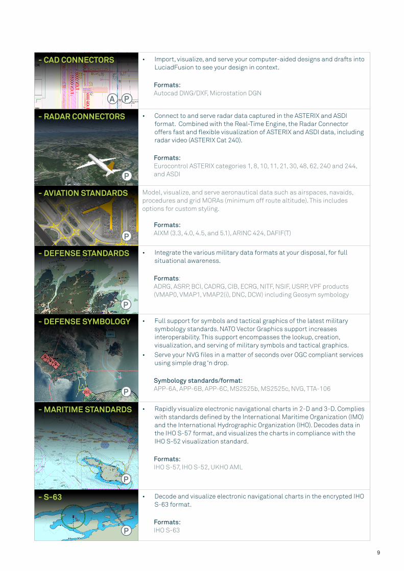
- CAD CONNECTORS
• Import, visualize, and serve your computer-aided designs and drafts into LuciadFusion to see your design in context.
Formats:Autocad DWG/DXF, Microstation DGN
- RADAR CONNECTORS • Connect to and serve radar data captured in the ASTERIX and ASDI format. Combined with the Real-Time Engine, the Radar Connector offers fast and flexible visualization of ASTERIX and ASDI data, including radar video (ASTERIX Cat 240).
Formats:Eurocontrol ASTERIX categories 1, 8, 10, 11, 21, 30, 48, 62, 240 and 244, and ASDI
- AVIATION STANDARDS Model, visualize, and serve aeronautical data such as airspaces, navaids, procedures and grid MORAs (minimum off route altitude). This includes options for custom styling.
Formats:AIXM (3.3, 4.0, 4.5, and 5.1), ARINC 424, DAFIF(T)
- DEFENSE STANDARDS • Integrate the various military data formats at your disposal, for full situational awareness.
Formats:ADRG, ASRP, BCI, CADRG, CIB, ECRG, NITF, NSIF, USRP, VPF products (VMAP0, VMAP1, VMAP2(i), DNC, DCW) including Geosym symbology
- DEFENSE SYMBOLOGY • Full support for symbols and tactical graphics of the latest military symbology standards. NATO Vector Graphics support increases interoperability. This support encompasses the lookup, creation, visualization, and serving of military symbols and tactical graphics.
• Serve your NVG files in a matter of seconds over OGC compliant services using simple drag ‘n drop.
Symbology standards/format:APP-6A, APP-6B, APP-6C, MS2525b, MS2525c, NVG, TTA-106
- MARITIME STANDARDS • Rapidly visualize electronic navigational charts in 2-D and 3-D. Complies with standards defined by the International Maritime Organization (IMO) and the International Hydrographic Organization (IHO). Decodes data in the IHO S-57 format, and visualizes the charts in compliance with the IHO S-52 visualization standard.
Formats:IHO S-57, IHO S-52, UKHO AML
- S-63 • Decode and visualize electronic navigational charts in the encrypted IHO S-63 format.
Formats:IHO S-63
A P
P
P
P
P
P
P
9
DATA SHEET/V2018.0SERVER
LuciadFusion
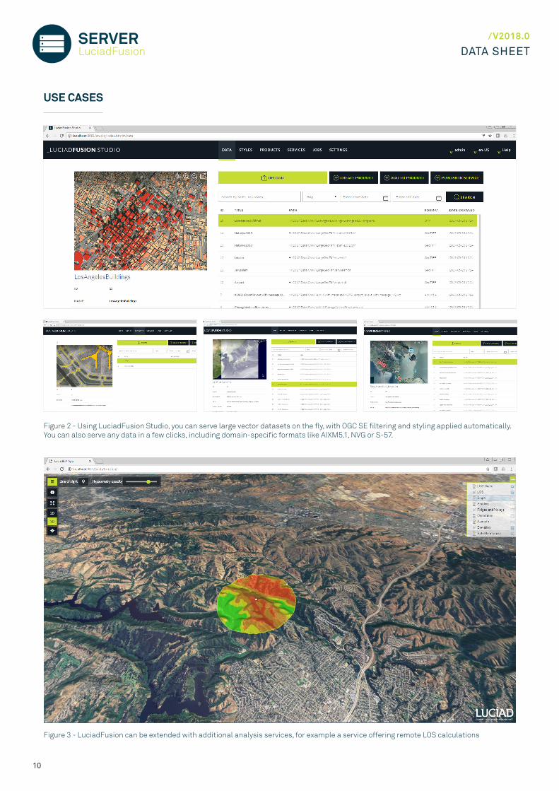
Figure 3 - LuciadFusion can be extended with additional analysis services, for example a service offering remote LOS calculations
Figure 2 - Using LuciadFusion Studio, you can serve large vector datasets on the fly, with OGC SE filtering and styling applied automatically. You can also serve any data in a few clicks, including domain-specific formats like AIXM5.1, NVG or S-57.
USE CASES
10

Figure 4 - Visualization and analysis of multi-dimensional weather data in Lucy, served by LuciadFusion as multidimensional WMTS
MORE INFORMATION
LuciadFusion comes with:
• Ready-to-use LuciadFusion Studio application
• Guided user tours
• In application help within LuciadFusion Studio
• Ready-to-use tiling engine application (DCM) with end-user guide
• Developer’s guide with clear explanations and description of best practices
• API reference offering detailed description of all interfaces and classes
• Code samples for all components
• Build script and sample servlet for easy deployment
• Release notes to see what’s new
• Technical notes to consult technical requirements
11
To learn more or schedule a demo, check out the Luciad Developer Platform at dev.luciad.com or contact us at [email protected].

www.luciad.com