Cuaternario y Geomorfología C G ISSN:...
16
23 Cuaternario y Geomorfología ISSN: 0214-1744 www.rediris.es/CuaternarioyGeomorfologia/ C y G Derechos de reproducción bajo licencia Creative Commons 3.0. Se permite su inclusión en repositorios sin ánimo de lucro. https://doi.org/10.17735/cyg.v32i3-4.67068 Debris flow triggering on Teide stratovolcano, Tenerife. A growing process? Desencadenamiento de debris flow en el volcán Teide. ¿Un proceso creciente? Criado, C. (1) ; Dorta, P. (1,2) ; Casanova, H. (1) ; González- Reimers, E (1) ; Arnay, M. (1) and Soler, V. (3) (1) Departamento de Geografía e Historia. Universidad de La Laguna. 38071 La Laguna, Tenerife, Spain. [email protected] (2) Cátedra de Reducción de Riesgo de Desastres. Ciudades Resilientes. Universidad de La Laguna. 38071 La Laguna, Tenerife, Spain (3) Instituto de Productos Naturales y Agrobiología (IPNA), CSIC. 38204 La Laguna, Tenerife, Spain. Abstract Mt. Teide is the highest mountain on Spanish territory (3,718 m.a.s.l.). It is a twin stratovolcano: Pico Viejo (3,100 m.a.s.l.) has a comparavely wide crater while the Pico del Teide crater itself, slightly to the east, last erupted possibly 1.2 ky BP (Lavas Negras). Below the modern lava flows, the Old Teide structure outcrops as a giant edifice; its most recent materials have been dated at 30 ky. The volcano shows very steep slopes (over 40 o ) with several prominent ravines, the most important being Corredor de La Bola and Corredor de La Cor- bata. The laer has been parally infilled by the Lavas Negras erupon. At its head there is a pale-coloured triangular area caused by intense fumarole weathering of phonolic rocks. The fluvial acvity of this ravine has not been relevant, there is a lack of references to it for at least the last 30 years. However, on September 22 nd , 2010, heavy rain remobilized materials from the pale area (located at over 3,200 m.a.s.l.), causing an impressive debris flow. In the present paper we report the results of a morphometric, sedimentological and climac study focusing on the unusual weather condions that triggered this process, as a key to understan- ding other previous and future debris flows. Key words: Debris flow; Teide volcano; heavy rains; tropical storm; Tenerife; Canary Islands. Resumen El volcán Teide es la montaña más elevada del territorio español, alcanzando los 3.718 m.s.n.m. Es un estrato- volcán doble; el volcán de Pico Viejo (3.100 m.s.n.m) presenta un cráter amplio, mientras que el volcán Teide, en posición más oriental, tuvo su úlma erupción hace posiblemente 1,2 ka (Lavas Negras). Por debajo de
Transcript of Cuaternario y Geomorfología C G ISSN:...

23
Cuaternario y GeomorfologíaISSN: 0214-1744
www.rediris.es/CuaternarioyGeomorfologia/Cy
G
Derechos de reproducción bajo licencia Creative Commons 3.0. Se permite su inclusión en repositorios sin ánimo de lucro.
https://doi.org/10.17735/cyg.v32i3-4.67068
Debris flow triggering on Teide stratovolcano, Tenerife. A growing process?
Desencadenamiento de debris flow en el volcán teide. ¿un proceso creciente?
Criado, C. (1); Dorta, P. (1,2); Casanova, H. (1); González-Reimers, E (1); Arnay, M. (1) and Soler, V. (3)
(1) Departamento de Geografía e Historia. Universidad de La Laguna. 38071 La Laguna, Tenerife, Spain. [email protected]
(2) Cátedra de Reducción de Riesgo de Desastres. Ciudades Resilientes. Universidad de La Laguna. 38071 La Laguna, Tenerife, Spain
(3) Instituto de Productos Naturales y Agrobiología (IPNA), CSIC. 38204 La Laguna, Tenerife, Spain.
Abstract
Mt. Teide is the highest mountain on Spanish territory (3,718 m.a.s.l.). It is a twin stratovolcano: Pico Viejo (3,100 m.a.s.l.) has a comparatively wide crater while the Pico del Teide crater itself, slightly to the east, last erupted possibly 1.2 ky BP (Lavas Negras). Below the modern lava flows, the Old Teide structure outcrops as a giant edifice; its most recent materials have been dated at 30 ky. The volcano shows very steep slopes (over 40o) with several prominent ravines, the most important being Corredor de La Bola and Corredor de La Cor-bata. The latter has been partially infilled by the Lavas Negras eruption. At its head there is a pale-coloured triangular area caused by intense fumarole weathering of phonolitic rocks. The fluvial activity of this ravine has not been relevant, there is a lack of references to it for at least the last 30 years. However, on September 22nd, 2010, heavy rain remobilized materials from the pale area (located at over 3,200 m.a.s.l.), causing an impressive debris flow. In the present paper we report the results of a morphometric, sedimentological and climatic study focusing on the unusual weather conditions that triggered this process, as a key to understan-ding other previous and future debris flows.
Key words: Debris flow; Teide volcano; heavy rains; tropical storm; Tenerife; Canary Islands.
Resumen
El volcán Teide es la montaña más elevada del territorio español, alcanzando los 3.718 m.s.n.m. Es un estrato-volcán doble; el volcán de Pico Viejo (3.100 m.s.n.m) presenta un cráter amplio, mientras que el volcán Teide, en posición más oriental, tuvo su última erupción hace posiblemente 1,2 ka (Lavas Negras). Por debajo de

24
Cuaternario y Geomorfología (2018), 32 (3-4), 23-38
1. Introduction
Debris flows are typical deposits in arid and semiarid environments; they are a flow of se-diments formed of mixed coarse and fine par-ticles, water and air (Gutiérrez-Elorza, 2001). The water build-up necessary to cause such flows is provided by heavy rain or sudden mel-ting of the snow cover. On this topic there is a wide literature (Innes, 1983; Costa, 1984 and 1988; Johnson and Rudine, 1984; Takahashi, 1991; Coussot and Meunier, 1996; Harvey, 1997;) referring to debris flows in high moun-tain zones (Berti et al., 1999) and high latitu-des (Rapp and Nyberg, 1981), and of course in volcanic areas (Palacios et al., 1998 and 1999; Palacios, 1999; Zanchetta et al., 2004; Ettin-ger et al., 2007). Some of the debris flows on Teide have already been described (Criado, 2006; Criado et al., 2008; Rodríguez-González et al., 2013).
The main aim of this paper focused in an event of debris flow happened on 22th Sep-tember 2010 in the Corredor of La Corbata (Teide volcano, Tenerife, Fig. 1). In this case, the movement started when the amount of water mixed with fine particles produced by the fumaroles weathering and debris from La-vas Negras, produced a drop in viscosity and shear resistance (Johnson, 1970).
The objectives of this research are the preci-se characterization of the phenomena —ba-
sed in morphometrical and sedimentological study of the debris flow—, together with a detailed study of the weather conditions responsible for its genesis, to get the key to understand these processes in the Late Holo-cene evolution of Teide and its implication in the formation of some alluvial fans and also to implement the surveillance of debris flow as a natural hazard able to risk people and in-frastructure.
2. Geomorphological and climate frameworks
Teide volcano complex, located on the island of Tenerife (Fig. 1), rises from 2,000 m high on its northern face and from 2,300 m on the southern face, reaching around 3,500 m high (Fig. 2), where there is a small plateau from which the terminal cone rises further to 3,718 m.a.s.l. It is a high altitude environ-ment, which explains the climatic features of this mountain sector of Tenerife. The slopes are very steep, with gradients from 30o to 40o, rising continuously to a height of 1,500 m above the surrounding cirque floor. The present volcanic edifice started to build up 198 ky ago, with a large volume of basaltic lava flows. From 115 to 30 ky BP, Teide kept growing, but the rate of issue was progressi-vely more moderate (Carracedo et al., 2003) and the magma increasingly differentiated, ranging from basalts to phonotephrite (Carra-
estos flujos lávicos recientes aflora la estructura del Teide Antiguo, un edificio gigante cuyos materiales más recientes han sido datados en 30 ka. Presenta laderas muy empinadas (por encima de 40o) y muestra algunos barrancos, siendo los más importantes el Corredor de La Bola y el Corredor de La Corbata. Este último ha sido parcialmente rellenado por las Lavas Negras. En su cabecera presenta una coloración pálida, con forma de triángulo, producida por una intensa alteración fumaroliana afectando a la roca fonolita. La actividad de este barranco no ha sido muy importante no existiendo referencias de ella para los últimos 30 años. Sin embargo, el 22 de septiembre de 2010 una lluvia intensa produjo la removilización de materiales desde la mancha pálida (localizada por encima de los 3.200 m.s.n.m.), formando un debris flow impresionante. En el presente artículo mostramos los resultados del estudio morfométrico, sedimentológico y climático, haciendo hincapié en las inusuales condiciones meteorológicas que produjeron el desencadenamiento de este proceso como clave para interpretar otros debris flow anteriores y prevenir el riesgo derivado de los futuros.
Palabras clave: Debris flow; volcán Teide; lluvias torrenciales; tormenta tropical; Tenerife; islas Canarias.
25
Cuaternario y Geomorfología (2018), 32 (3-4), 23-38
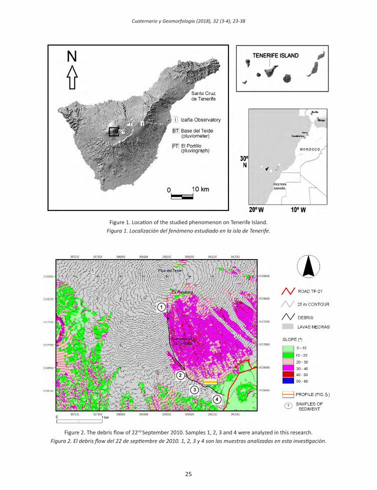
Figure 1. Location of the studied phenomenon on Tenerife Island.figura 1. localización del fenómeno estudiado en la isla de tenerife.
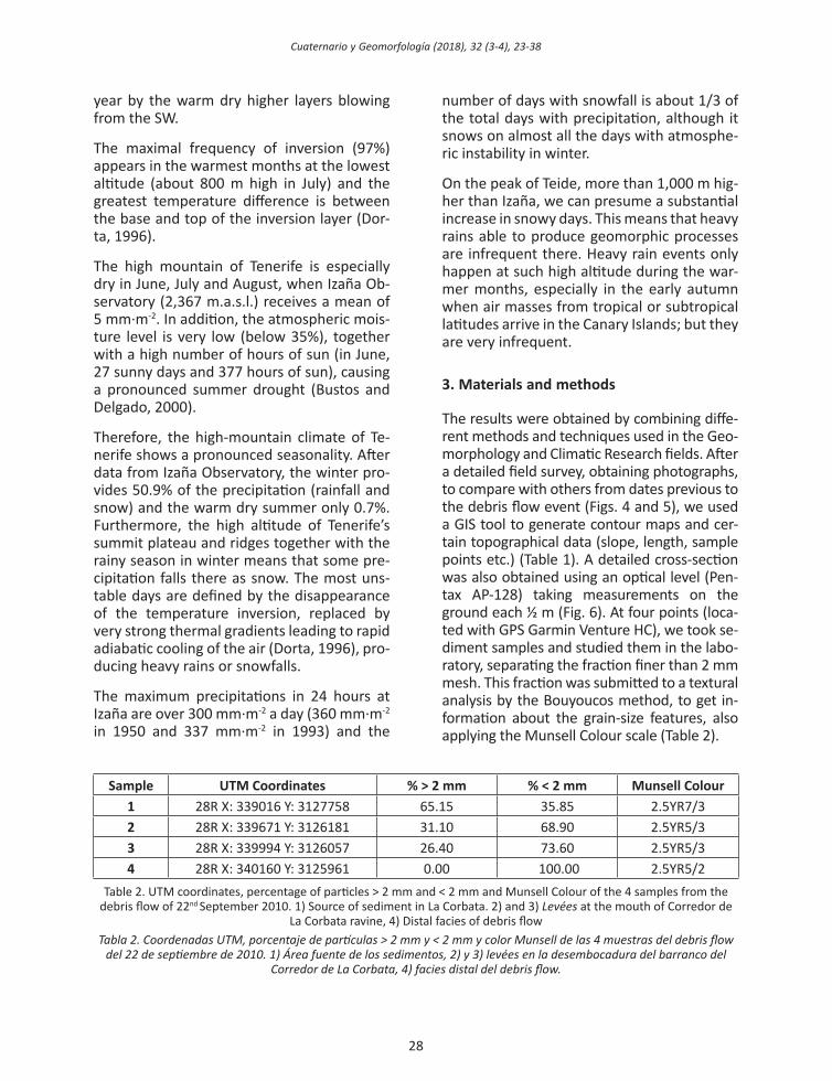
Figure 2. The debris flow of 22nd September 2010. Samples 1, 2, 3 and 4 were analyzed in this research.Figura 2. El debris flow del 22 de septiembre de 2010. 1, 2, 3 y 4 son las muestras analizadas en esta investigación.

26
Cuaternario y Geomorfología (2018), 32 (3-4), 23-38
cedo, 2006). The terminal cone was formed during the more recent eruption with phono-lite composition (Carracedo, 2006; Carracedo et al., 2003, 2007 2013). Even today, in the small summit crater of the volcano there is a fumarole field with emissions of H2O, CO2, H2S and SO2 (Carracedo and Soler, 1983), which have produced considerable weathering of the rocky outcrops. Most of the whole cen-tral volcanic cone is covered by Lavas Negras (Fig. 2) issued during the last eruption, dated in XV Century AD by palaeomagnetism (Soler et al., 1984; Soler and Carracedo, 1986) and at 1150±140 BP using 14 C (Carracedo, 2006; Carracedo et al., 2003, 2007, 2013 ). Eroded outcrops remain in the areas free from this recent lava layer, mainly on the southern slo-pe, notably the ravines called Corredor de La Bola and Corredor de la Corbata (Martínez de Pisón and Quirantes, 1981; Bravo and Bra-vo-Bethencourt, 1989; Criado, 2006; Criado et al., 2008; Rodríguez-González et al., 2013).
The debris described in the present study is located within the Corredor de La Corbata (c. 100 m deep), extending from 3,350 m down to 2,285 m.a.s.l. and involving an area of 0.74 km2 (Table 1). This ravine was largely formed between 30 ky and 1.2 ky ago, because it is partially infilled by Lavas Negras (Fig. 2).
Area of ravine (km2) 0.74Maximum height (m) 3,350Minimum height (m) 2,285Mean slope of basin (o) 30-40Length of debris flow (m) 2,505Volume (m3) ~30,000Mean slope of debris flow (o) 30-40
Table 1. Morphometry of debris flow on 22nd September 2010.
Tabla 1. Morfometría del debris flow del 22 de septiembre de 2010.
The morphogenetic activity of this ravine is weak nowadays, although alluvial fans are well developed at its foot, one of them (Ca-ñada Blanca) reaches more than 3 km in length. A detailed survey showed abundant archaeological remains (pottery, stone wall
remnants of huts, and lithic artifacts) from the Guanche culture, spread sparsely over the several debris flows. A goat bone located in hut sites provided a 14C dating in 910±30 BP (Beta-330031). So we can suppose that most of that debris flow was deposited before the XVI century AD, since from then onwards the Guanche culture was progressively absorbed by their European conquerors.
In the eastern sector of the base of Teide, the alluvial fans overlapped lava flows from phase VIII of the Montaña Blanca dome (Carracedo, 2006), dated at 2 ky BP (Ablay et al., 1995). These are in turn covered in some places by the Lavas Negras flows. To the west, the same lava flow covered debris flows in the proxi-mal sector of the Cañada Blanca alluvial fan (Criado et al., 2008; Rodríguez-González et al., 2013). Therefore, the most important pro-cesses of alluvial-fan formation appear to be old, since only a few levées rich in stones and blocks without archaeological remains have been dated as after XVI century AD (Fig. 3).
Today close to the mouth of both corridors there is a cable-car, operating since 1971 and used by a big number of people.
On the other hand, the climate of the Canary Islands is characterized by atmospheric stabi-lity with a very low number of rainy days per year. However, events of strong instability may occur in short space and time scales. The significant reliefs of the islands create impor-tant pluviometric differences both in terms of total annual rainfall as in the intensity of indi-vidual events, with remarkable geographical contrast (Mayer et al., 2017). In this context the high Canary summits and, consequently, the Teide National Park have singular features that make them different from other areas located at mid and low elevations where the population is concentrated.
Atmospheric stability is the usual climatic re-gime in Teide National Park. Due to the alti-tude (over 2,000 m.a.s.l.) being higher than the thermal inversion above the prevailing NE trade-winds, the area is affected most of the

27
Cuaternario y Geomorfología (2018), 32 (3-4), 23-38
Figure 3. Geomorphological map and cross-section of debris flows at the junction of the Corredor de la Bola and Corredor de la Corbata ravines and detailed cross section along A-A’ (UTM coordinates, WGS84 datum)
(after Rodríguez-González et al., 2013).Figura 3. Mapa geomorfológico y perfil de los debris flows situados en la confluencia de los barrancos del Corredor de La
Bola y del Corredor de la Corbata y corte detallado a lo largo de a-a’ (coordenadas utm, Wgs84 datum) (según rodríguez-gonzález et al., 2013).
28
Cuaternario y Geomorfología (2018), 32 (3-4), 23-38
year by the warm dry higher layers blowing from the SW.
The maximal frequency of inversion (97%) appears in the warmest months at the lowest altitude (about 800 m high in July) and the greatest temperature difference is between the base and top of the inversion layer (Dor-ta, 1996).
The high mountain of Tenerife is especially dry in June, July and August, when Izaña Ob-servatory (2,367 m.a.s.l.) receives a mean of 5 mm·m-2. In addition, the atmospheric mois-ture level is very low (below 35%), together with a high number of hours of sun (in June, 27 sunny days and 377 hours of sun), causing a pronounced summer drought (Bustos and Delgado, 2000).
Therefore, the high-mountain climate of Te-nerife shows a pronounced seasonality. After data from Izaña Observatory, the winter pro-vides 50.9% of the precipitation (rainfall and snow) and the warm dry summer only 0.7%. Furthermore, the high altitude of Tenerife’s summit plateau and ridges together with the rainy season in winter means that some pre-cipitation falls there as snow. The most uns-table days are defined by the disappearance of the temperature inversion, replaced by very strong thermal gradients leading to rapid adiabatic cooling of the air (Dorta, 1996), pro-ducing heavy rains or snowfalls.
The maximum precipitations in 24 hours at Izaña are over 300 mm·m-2 a day (360 mm·m-2 in 1950 and 337 mm·m-2 in 1993) and the
number of days with snowfall is about 1/3 of the total days with precipitation, although it snows on almost all the days with atmosphe-ric instability in winter.
On the peak of Teide, more than 1,000 m hig-her than Izaña, we can presume a substantial increase in snowy days. This means that heavy rains able to produce geomorphic processes are infrequent there. Heavy rain events only happen at such high altitude during the war-mer months, especially in the early autumn when air masses from tropical or subtropical latitudes arrive in the Canary Islands; but they are very infrequent.
3. Materials and methods
The results were obtained by combining diffe-rent methods and techniques used in the Geo-morphology and Climatic Research fields. After a detailed field survey, obtaining photographs, to compare with others from dates previous to the debris flow event (Figs. 4 and 5), we used a GIS tool to generate contour maps and cer-tain topographical data (slope, length, sample points etc.) (Table 1). A detailed cross-section was also obtained using an optical level (Pen-tax AP-128) taking measurements on the ground each ½ m (Fig. 6). At four points (loca-ted with GPS Garmin Venture HC), we took se-diment samples and studied them in the labo-ratory, separating the fraction finer than 2 mm mesh. This fraction was submitted to a textural analysis by the Bouyoucos method, to get in-formation about the grain-size features, also applying the Munsell Colour scale (Table 2).
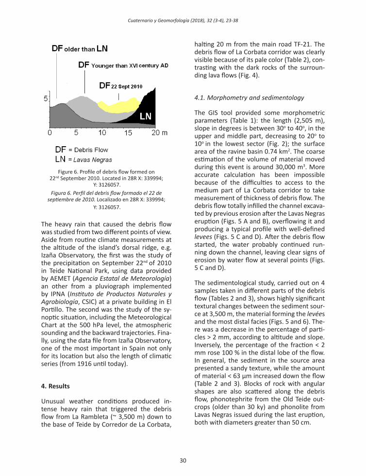
Sample UTM Coordinates % > 2 mm % < 2 mm Munsell Colour 1 28R X: 339016 Y: 3127758 65.15 35.85 2.5YR7/32 28R X: 339671 Y: 3126181 31.10 68.90 2.5YR5/33 28R X: 339994 Y: 3126057 26.40 73.60 2.5YR5/34 28R X: 340160 Y: 3125961 0.00 100.00 2.5YR5/2
Table 2. UTM coordinates, percentage of particles > 2 mm and < 2 mm and Munsell Colour of the 4 samples from the debris flow of 22nd September 2010. 1) Source of sediment in La Corbata. 2) and 3) levées at the mouth of Corredor de
La Corbata ravine, 4) Distal facies of debris flowTabla 2. Coordenadas UTM, porcentaje de partículas > 2 mm y < 2 mm y color Munsell de las 4 muestras del debris flow
del 22 de septiembre de 2010. 1) Área fuente de los sedimentos, 2) y 3) levées en la desembocadura del barranco del Corredor de La Corbata, 4) facies distal del debris flow.

29
Cuaternario y Geomorfología (2018), 32 (3-4), 23-38
Figure 4. View of Corredor de la Corbata. On the left, before 22nd September 2010: on the right, the appearance of channel infill with pale sediments washed down from the fumarole area near the top (~3,500 m).
Figura 4. Vista del Corredor de La Corbata. A la izquierda antes del 22 de septiembre de 2010; a la derecha, aspecto del canal relleno con los sedimentos de color claro arrastrados desde el área fumaroliana próxima a la cumbre (~3.500 m).
Figure 5. Image of channel eroded by run-off down the ravine after 1.2 ky: A) before 22nd September and B) a few days later. The pale sediments covering the channel are clearly visible (in photo number A the man inside the circle provide
the scale). C) and D) view of debris flow infilling the channel in the distal area. Figura 5. Imagen del canal excavado por el barranco después de 1,2 ka. A) Antes del 22 de septiembre y B) días más
tarde. Podemos ver los sedimentos de color claro cubriendo el canal (La figura del hombre dentro del círculo en la foto A proporciona la escala). C) y D) aspecto del debris flow en el área distal.
30
Cuaternario y Geomorfología (2018), 32 (3-4), 23-38
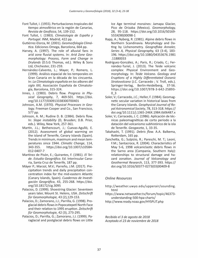
Figure 6. Profile of debris flow formed on 22nd September 2010. Located in 28R X: 339994;
Y: 3126057.Figura 6. Perfil del debris flow formado el 22 de
septiembre de 2010. Localizado en 28R X: 339994; Y: 3126057.
The heavy rain that caused the debris flow was studied from two different points of view. Aside from routine climate measurements at the altitude of the island’s dorsal ridge, e.g. Izaña Observatory, the first was the study of the precipitation on September 22nd of 2010 in Teide National Park, using data provided by AEMET (agencia estatal de meteorología) an other from a pluviograph implemented by IPNA (Instituto de Productos Naturales y agrobiología, CSIC) at a private building in El Portillo. The second was the study of the sy-noptic situation, including the Meteorological Chart at the 500 hPa level, the atmospheric sounding and the backward trajectories. Fina-lly, using the data file from Izaña Observatory, one of the most important in Spain not only for its location but also the length of climatic series (from 1916 until today).
4. Results
Unusual weather conditions produced in-tense heavy rain that triggered the debris flow from La Rambleta (~ 3,500 m) down to the base of Teide by Corredor de La Corbata,
halting 20 m from the main road TF-21. The debris flow of La Corbata corridor was clearly visible because of its pale color (Table 2), con-trasting with the dark rocks of the surroun-ding lava flows (Fig. 4).
4.1. morphometry and sedimentology
The GIS tool provided some morphometric parameters (Table 1): the length (2,505 m), slope in degrees is between 30o to 40o, in the upper and middle part, decreasing to 20o to 10o in the lowest sector (Fig. 2); the surface area of the ravine basin 0.74 km2. The coarse estimation of the volume of material moved during this event is around 30,000 m3. More accurate calculation has been impossible because of the difficulties to access to the medium part of La Corbata corridor to take measurement of thickness of debris flow. The debris flow totally infilled the channel excava-ted by previous erosion after the Lavas Negras eruption (Figs. 5 A and B), overflowing it and producing a typical profile with well-defined levees (Figs. 5 C and D). After the debris flow started, the water probably continued run-ning down the channel, leaving clear signs of erosion by water flow at several points (Figs. 5 C and D).
The sedimentological study, carried out on 4 samples taken in different parts of the debris flow (Tables 2 and 3), shows highly significant textural changes between the sediment sour-ce at 3,500 m, the material forming the levées and the most distal facies (Figs. 5 and 6). The-re was a decrease in the percentage of parti-cles > 2 mm, according to altitude and slope. Inversely, the percentage of the fraction < 2 mm rose 100 % in the distal lobe of the flow. In general, the sediment in the source area presented a sandy texture, while the amount of material < 63 μm increased down the flow (Table 2 and 3). Blocks of rock with angular shapes are also scattered along the debris flow, phonotephrite from the Old Teide out-crops (older than 30 ky) and phonolite from Lavas Negras issued during the last eruption, both with diameters greater than 50 cm.

31
Cuaternario y Geomorfología (2018), 32 (3-4), 23-38
4.2. the storm of 22th september 2010
This rainfall event was produced by a synop-tic situation with a talweg in the high atmos-phere and an invasion of air coming from the South, causing a pronounced tropicalization in the lower layers of the atmosphere, pro-ducing rains over the whole Canary archi-pelago (Fig. 7). The instability was clearly visible in the vertical structure of the atmos-phere (Fig. 8). The thermodynamic sounding distinguishes winds coming from the SE and SW, with a clear S component throughout the troposphere. A similar conclusion can be drawn from backward trajectories (Fig. 9). Thus, the temperature was over 0o C up to 4,100 m. a.s.l., which can produce precipita-tion as rain even on the highest slopes of the volcano.
The maximal rainfall rose to more than 80 mm·m-2 in sectors of Teide National Park ex-posed to the SW. In this way the mass of Teide acted as a collecting screen against the moist unstable air coming from the SW.
The precipitation data provides reliable evi-dence of the magnitude of this rain event in the area of Teide National Park (Table 4). For instance, according to data from the observa-tory network of AEMET, at Izaña 45.8 mm·m-2
(three times the average September mean of 15 mm·m-2) were collected on the 21st and 22nd. At the Base of Teide, the total 96.0 mm·m-2 was more than 25% of the annual mean total (355.8 mm·m-2).
The data available from the pluviograph ins-talled in the El Portillo area, which provides a cumulative recording of rain each 30 minu-tes, permits a hyetograph of this storm to be drawn (Fig. 10). Located in a comparatively flat area at some distance from the prominent reliefs, it collected 18 mm·m-2 between 13.30 and 17.30 h on the 22nd. Of this, 15 mm·m-
2 (83.3%) fell uninterruptedly from 13.30 to 16.00 h, giving an intensity of 6 mm·m-2.h-1. Assuming a similar behavior of the rain at the Base del Teide pluviometer (the only one lo-cated on the volcano itself), from the total of 96.0 mm·m-2 80 mm (83,3%) could have fall between 13.30 – 16.00, resulting in an inten-sity of 32 mm·m-2.h-1.
Pluviometer Altitude (m) PrecipitationBase Teide 2,320 96.0
La Angostura 2,341 58.0Llano Ucanca 2,020 87.3Encerradero 2,100 118.3Boca Tauce 2,050 131.0
Tiro Ema 2,071 108.1Diego Hernández 2,145 50.0
Risco Verde 2,100 54.4Izaña 2,367 45.8
El Portillo 2,137 84.0Centro Visitantes 2,100 69.0Table 4. Precipitation registered in the pluviometers
in Teide National Park during the storm on 22nd September 2010. Data from AEMET.
tabla 4. precipitaciones en los diferentes pluviómetros del parque nacional del teide producidas por la
tormenta de septiembre de 2010.Fuente: AEMET.
sSample % Coarse sand % Fine sand % Coarse silt % Fine silt % Clay1 76.27 11.12 2.15 5.41 5.052 63.19 15.17 3.72 9.34 8.583 52.56 19.87 5.04 12.66 9.874 25.23 42.45 6.54 16.44 9.34
Table 3. Texture of the 4 samples of the debris flow of 22nd September 2010. 1) Source of sediment in La Corbata. 2) and 3) levées at the mouth of Corredor de La Corbata ravine, 4) Distal facies of debris flow.
Tabla 3. Textura de las 4 muestras del debris flow del 22 de septiembre de 2010. 1) Área fuente de los sedimentos, 2) y 3) levées en la desembocadura del barranco del Corredor de La Corbata, 4 facies distal del debris flow.

32
Cuaternario y Geomorfología (2018), 32 (3-4), 23-38
Figure 7. Meteorological chart at 500 hPa on 22nd September 2010 at 12 UTC. Avalaible at https://www.netweather.tv/forum/topic/46373-understanding-500-hpa-charts/
Figura 7. Mapa meteorológico en el nivel de 500 hPa del miércoles 22 de septiembre de 2010 a 12 UTC. Disponible en https://www.netweather.tv/forum/topic/46373-understanding-500-hpa-charts/
Figure 8. Sounding taken at Güímar meteorological station on 22nd September, 2010. Note the above-zero temperatures at altitudes higher than 3,100 m.a.s.l. Avalaible at http://weather.uwyo.edu/upperair/sounding.html
Figura 8. Sondeo termodinámico de la estación de Güímar del 22 de septiembre de 2010. Podemos ver temperaturas positivas por encima de los 3.100 m.s.n.m. Disponible en http://weather.uwyo.edu/upperair/sounding.html

33
Cuaternario y Geomorfología (2018), 32 (3-4), 23-38
Figure 10. Hyetograph of the storm of 2010. Data taken by a pluviograph installed by IPNA in El Portillo.Figura 10. Hietograma de la tormenta del 2010. Datos tomados en un pluviógrafo instalado por el IPNA en El Portillo.
Figure 9. Backward trajectories ending at 1800 UTC on 22nd September 2010. Avalaible at http://www.ready.noaa.gov/HYSPLIT.php
Figura 9. Retrotrayectorias terminando a las 18.00 UTC del 22 de septiembre de 2010. Disponible en http://www.ready.noaa.gov/HYSPLIT.php

34
Cuaternario y Geomorfología (2018), 32 (3-4), 23-38
5. Discussion
Using the data from Izaña Observatory, it has been possible to detect rain events similar to that of the 22nd September 2010. The statis-tical analysis of rainfall with totals above 30 mm·day-1 and temperature with minima over 6o C provided an estimate of 15 storms, of which only one was during the spring (May), and summer (August) (Table 5), in the recent years, and the main part in autumn. There is a marked concentration in the 1950s, a pe-riod with very abundant rainfall in general for the Canary Archipelago (Hernández-Calvento et al., 1999), moreover a similar situation is perceived in the recent years corresponding to the XXI century (Table 5).
Some of these events (Table 5) show a striking arrival of air from southern latitudes. For instan-ce the situation in September 1951, studied by
Font Tullot (1983), was classified as due to tro-pical depressions (Font Tullot, 1955 and 1983).
Therefore, the only weather syndromes able to produce runoff down ravines on Teide are ‘warm’ storms, which happen in early Au-tumn or Summer, as recently as 2015, but without significant torrential dynamics in the Teide ravines. In that year, from 8th to 14th Au-gust, Izaña received 66.2 mm·m-2 of rain, of which 21.6 mm·m-2 from 0 to 6 UTC was on the 14th, but without consequences in the debris flow. That rain probably did not fall on Teide volcano itself but in surrounding areas. In this sense it is important to highlight the statistically significant increase, of summer precipitations in the Canary Islands, especia-lly in the high summits (Dorta et al., 2018). These precipitations always fall as rain with an intensity corresponding to stormy events. An example is the atmospheric situation oc-
Date Minimum temperature
Estimated temperature at 3,500 m (=0.5o C per 100 m)
Maximum wind speed (m·sec-1)
Dir Rain (mm·m2)
22 May 1927 8.4 2.4 32.622 Oct 1927 6.6 0.6* 80.69 Oct 1937 7.8 1.2* 51.4
30 Sept 1950 6.5 0.5* 17.2 200 31.49 Nov 1950 6.4 0.4* 28.1 180 124.0
20 Sept 1951 10.8 4.8 23.1 130 62.726 Nov 1952 7.0 1.0* 17.8 200 43.78 Oct 1953 6.6 0.6 28.9 290 48.4
30 Sept 1955 8.6 2.6 13.1 130 56.212 Sept 1967 8.4 2.4 20.0 230 75.913 Sept 1967 6.4 0.4* 22.8 320 58.422 Sept 2010 9.6 3.6 24.4 180 44.211 Oct 2010 7.5 1.5* 25.3 280 41.018 Aug 2005+ 11.3 5.3 21.4 190 29.119 Oct 2014 12.2 6.2* 32.2 260 54.413 Aug 2015 10.0 4.0 27.7 190 59.2
Table 5. Weather parameters of the 13 storms with heavy rains and temperatures over 0o C, recorded at Izaña (2,351 m a.s.l.). *High probability of snowfall at 3,500 m.a.s.l. +Although this datum did not exceed 30 mm, it approaches the
chosen value of 30 mm. The previous day (17th August) another heavy shower fell, registering 20.3 mm. tabla 5. parámetros meteorológicos de 13 tormentas con lluvias intensas y temperatura por encima de los 0o C
registradas en izaña (2.351 m.s.n.m.). *alta probabilidad de nevadas a 3.500 m.s.n.m. +a pesar de que el dato no excede de 30 mm, muestra un valor muy próximo a la cantidad elegida de 30 mm y además el día anterior (17 de agosto) cayó
otra lluvia de 20,3 mm.

35
Cuaternario y Geomorfología (2018), 32 (3-4), 23-38
curred on August 2015 (Table 5). This kind of storms could increase the number of debris flow events like the one showed in this paper.
6. Conclusions
There is no documentary or verbal record of debris flows generated on the southern slo-pes of Teide volcano for at least the last thir-ty years, although stormy weather producing heavy rains is normal at Izaña Observatory, where the climate series reaches back to 1916. This usually happens during the coldest season, producing snowfalls above 2,000 m. In this way, the snowfall produces a tempo-rary covering layer, undergoing intense subli-mation (related to the very low air-humidity value) and gradual melting. In addition, the water produced by the melted snow perco-lates into a very porous substrate, formed mainly of rock debris.
However, the substratum is determinant in the triggering of debris flows; the presence of fine material (like sand or silt) is necessary to form the matrix of sediment mixed with water that causes the movement. This condition was ful-filled in the triggering of the debris flow down Corredor de La Corbata, at the top of which there is a clearly visible outcrop of fine pale material produced by fumarole weathering.
This paper forms a basis for future research monitoring carefully the activity of these ravi-nes during the late Summer or early Autumn, when the weather conditions lead to rain at the peak of Teide. This could unleash further debris flows down Corredor de La Corbata ravine and debris falls and slides in other ra-vines on the southern slope of Teide, a hazar-dous area regarding the increasing number of cable-car passengers.
The installation of automatic pluviograph de-vices would be highly advantageous to record rainfall at the top and mouth of Corredor de La Corbata (both places with easy access). Web-cameras would also be very useful to study the effect of rain on the ravine dyna-mics.
The frequency of summer thunderstorms with heavy rain in the Canary Islands is growing during recent years (Máyer et al., 2017, Dor-ta et al., 2018). Quite probably, the increased number of ‘warm’ storms during the summer and early Autumn are due to tropical air arri-ving in the current context of climate change (Dorta et al., 2018). In this way, Izaña Obser-vatory has recorded an increase of 0.8o C in the average annual temperature during its history (1916-until today), together with a de-crease in the number of days with snowfall. In addition, the high-mountain area of the Ca-nary Islands where warming is more evident has undergone a rapid increase in tempera-ture, particularly since the 1970s (Martín et al., 2012). For this reason an increased num-ber of events like that analysed in this paper would be highly probable if the current trends in Global Climatic Change continue.
In addition, this study allows to understand the weather conditions able to produce the genesis of previous debris flows on Teide vol-cano. The main part of them took place bet-ween the 2 ky BP (lava flow from the Mon-taña Blanca dome) and 1.2 ky BP (the Lavas Negras eruption) (Ablay et al., 1995; Ablay and Martí, 2000; Carracedo, 2006; Carracedo et al., 2003, 2007, 2013; Criado, 2006; Criado et al., 2008; Rodríguez-González et al., 2013). This relative dating coincides with the Roman Warm Period, which probably received more abundant storms from Southern latitudes, in-volving heavy rains with temperatures over 0o C at altitudes higher than 3,000 m. More recent debris flows, without archaeological remains, could had been produced during historical times (< 0.5 ky BP), pointing to ex-ceptional stormy weather like the hurricane of 1826 (Bethencourt-González and Dorta-Antequera, 2010).
Acknowledgements
The authors wish to thank to the anonymous referees for their useful comments, which have improved the quality and presentation of this work. This research has been carried out inside of the Project OAPN 328-11: estu-

36
Cuaternario y Geomorfología (2018), 32 (3-4), 23-38
dio sobre el patrimonio arqueológico del par-que nacional del teide. Our thanks to the staff of AEMET (Santa Cruz de Tenerife) and Teide National Park by their kindness. Springer Ver-lag authorized the reproduction of Figure 3.
References
Ablay, G.J.; Ernst, G.G.J.; Martí, J.; Spark, R.J.S. (1995). The subplinian eruption of Montaña Blanca, Tenerife. Bulletin of Volcanology, 57, 337-355.
Ablay, G.J.; Martí, J. (2000). Stratigraphy, structu-re, and volcanic evolution of the Pico Teide-Pico Viejo formation, Tenerife, Canary Is-lands. journal of Volcanology and geothermal research, 103 (1-4), 175-208. https://doi.org/10.1016/S0377-0273(00)00224-9
Berti, M.; Genevois, R.; Simoni, A.; Teca, P. R. (1999). Field observations of a debris flow event in Dolomites. geomorphology, 29, 265-274. https://doi.org/10.1016/S0169-555X(99)00018-5
Bethencourt-González, J.; Dorta-Antequera, P. (2010). The storm of the November 1826 in the Canary Islands: possibly a tropical cyclone? Geografíska Annaler. 92 (A), 3, 329-337. https://doi.org/10.1111/j.1468-0459.2010.00398.x
Bravo, T.; Bravo-Bethencourt, J. (1989). Mapa vol-canológico de Las Cañadas y Teide-Pico Viejo. In: los volcanes y la caldera del parque nacio-nal del teide (V. Araña; J. Coello, eds.). ICONA, Madrid. 443 pp.
Bustos, J.J. and Delgado, F. (2000). Climatología del Parque Nacional de Las Cañadas del Teide. http://www.iac.es/proyect/sitesting/TOPSI-TES/principal.html
Carracedo, J.C. (2006). el Volcán teide. CajaCana-rias, Santa Cruz de Tenerife. 429 pp.
Carracedo, J.; Soler, V. (1983). Anomalías térmicas asociadas al volcanismo en las Islas Canarias. V Asamblea Nacional de Geodesia y Geofísica, Madrid. Vol. Com.: 2351-2363.
Carracedo, J.C.; Paterne, M.; Guillou, H.; Pérez-To-rrado, F.; Paris, R.; Rodríguez-Badiola, E.; Han-sen, A. (2003). Dataciones radiométricas (14C y K/Ar) del Teide y el rift noroeste, Tenerife, Islas Canarias. estudios geológicos, 59, 15-29. https://doi.org/10.3989/egeol.03591-479
Carracedo, J.C.; Paterne, M.; Guillou, H.; Pérez-Torrado, F.; Paris, R.; Rodríguez-Badiola, E.; Hansen, A. (2007). Eruptive and structural
history of Teide Volcano and rift zones of Te-nerife, Canary Islands. geological society of america 119 (9-10), 1027-1051. https://doi.org/10.1130/B26087.1
Carracedo, J.C.; Guillou, H.; Pérez-Torrado, F.J.; Rodríguez-Badiola, E. (2013). Volcanic History and Stratigraphy of Teide Volcanic Complex. In: Teide Volcano. Geology and Eruptions of a Highly Differentiated Oceanic Stratovolcano (J.C. Carracedo; V. Troll, eds.). Springer-Ver-lag, Berlin-Heidelberg, 105-128. https://doi.org/10.1007/978-3-642-25893-0_7
Costa, J. E. (1984). Physical Geomorphology of debris flows. In: Developments and appli-cations of Geomorphology (J.E. Costa; P. eds.). Springer, Berlin, 268-317. https://doi.org/10.1007/978-3-642-69759-3_9
Costa, J.E. (1988). Rheologic, geomorphologic and sedimentologic differentiation of water floods, hyperconcentrated flows and debris flows. In: flood geomorphology (V.R. Baker; R. C. Cochel; P.C. Patton, eds.). Willey, New York, 113-122.
Coussot, P.; Meunier, M. (1996). Recognition, classification and mechanical description of debris flow. earth-science reviews, 40, 209-227. https://doi.org/10.1016/0012-8252(95) 00065-8
Criado, C. (2006). Geomorfología del Teide y de las dorsales activas. Parte II. Geomorfología cli-mática. los volcanes del parque nacional del Teide: el Teide, Pico Viejo y las dorsales activas de tenerife (J. C. Carracedo,ed.), OAPN-Minis-terio de Medio Ambiente, Madrid. 257-275.
Criado, C.; Arnay, M.; Bethencourt, J.; Holm, F.; Palacios, D.; González-Reimers, E. (2008). Alluvial fans on Teide Volcano. Preliminary results. In: trabajos de geomorfología en es-paña (2006-2008) (J. Benavente; F.J. Gracia, eds.). SEG, Cádiz, 397-400.
Dorta, P. (1996). Las inversiones térmicas en Cana-rias. Investigaciones Geográficas, 15, 109-124. https://doi.org/10.14198/INGEO1996.15.01
Dorta, P.; López, A.; Díaz, J. (2018) El calentamien-to global en el Atlántico Norte Suroriental. El caso de Canarias. Estado de la cuestión y pers-pectivas de futuro. Cuadernos Geográficos, vol. 57, 27-52. http://dx.doi.org/10.30827/cuadgeo.v57i2.5934
Ettinger, S.; Mothes, P.; Paris, R.; Schilling, S. (2007). The 1877 lahar deposits on the eas-tern flank of Cotopaxi volcano. geomorpho-logie: relief, processus, environnement, 3, 271-280. https://doi.org/10.4000/geomor-phologie.4022
37
Cuaternario y Geomorfología (2018), 32 (3-4), 23-38
Font Tullot, I. (1955). Perturbaciones tropicales del tiempo atmosférico en la región de Canarias, Revista de Geofísica, 54, 139-152.
Font Tullot, I. (1983). Climatología de españa y portugal. INM, Madrid, 422 pp.
Gutiérrez-Elorza, M. (2001). geomorfología Climá-tica. Ediciones Omega, Barcelona, 664 pp.
Harvey, A. (1997). The role of alluvial fans in arid zone fluvial systems. In: arid Zone geo-morphology: process, form and Change in Drylands (D.S.G Thomas, ed.). Wiley & Sons Ltd, Chichester, 231-259.
Hernández-Calvento, L.; Mayer, P.; Romero, L. (1999). Análisis espacial de los temporales en Gran Canaria en la década de los cincuenta. In: la Climatología española en los albores del siglo XXi, Asociación Española de Climatolo-gía, Barcelona, 315-324.
Innes, J. (1983). Debris flow. progress in phy-sical geography, 7, 469-501. https://doi.org/10.1177/030913338300700401
Johnson, A.M. (1970). physical processes in geo-logy. Freeman Cooper and Co., San Francisco, 577 pp.
Johnson, A. M.; Rudine D. B. (1984). Debris flow. In: slope instability (D, Brusden; D.B. Prior, eds.). Wiley, New York, 257-361.
Martín, J.L.; Bethencourt, J.; Cuevas-Agulló, E. (2012). Assessment of global warming on the island of Tenerife, Canary Islands (Spain). Trends in minimum, maximum and mean tem-peratures since 1944. Climatic Change, 114, 343-355. https://doi.org/10.1007/s10584-012-0407-7
Martínez de Pisón, E.; Quirantes, F. (1981). el tei-de. Estudio Geográfico. Ed. Interinsular Cana-ria, Santa Cruz de Tenerife, 187 pp.
Máyer P.; Marzol, M.V.; Parreño, J.M. (2017). Pre-cipitation trends and daily precipitation con-centration index for the mid-eastern Atlantic (Canary Islands, Spain). Cuadernos de Investi-gación Geográfica, 43, 255-268. https://doi.org/10.18172/cig.3095
Palacios, D. (1999). Shoestring Glacier: Seventeen years later, Mount St. Helens, USA. Zeitschrift für geomorphologie, 43 (2),129-153.
Palacios, D.; Zamorano, J.J.; Parrilla, G. (1998). Pro-glacial debris flows in Popocatepetl North Face and their relation to 1995 eruption. Zeitschrift für geomorphologie, 42 (3), 273-295.
Palacios, D.; Parrilla, G.; Zamorano, J.J. (1999). Pa-raglacial and postglacial debris flows on Little
Ice Age terminal moraines: Jamapa Glacier, Pico de Orizaba (Mexico). geomorphology, 28, 95-118. https://doi.org/10.1016/S0169-555X(98)00098-1
Rapp, A.; Nyberg, R. (1981). Alpine debris flows in Northern Scandinavia. Morphology and Da-ting by Lichenometry. Geografíska Annaler, series a, physical geography, 63 (3-4), 183-196. https://doi.org/10.1080/04353676.1981.11880033
Rodríguez-González, A.; Paris, R.; Criado, C.; Fer-nández-Turiel, J. (2013). The Teide volcanic complex: Physical Environment and Geo-morphology. In: teide Volcano. geology and Eruptions of a Highly Differentiated Oceanic stratovolcano (J.C. Carracedo ; V. Troll, eds.). Springer-Verlag, Berlin-Heidelberg, 37-56. https://doi.org/10.1007/978-3-642-25893-0_3
Soler, V.; Carracedo, J.C.; Heller, F. (1984). Geomag-netic secular variation in historical lavas from the Canary Islands. geophysical journal of ro-yal astronomical society, 78, 313-318. https://doi.org/10.1111/j.1365-246X.1984.tb06487.x
Soler, V.; Carracedo, J. C. (1986). Aplicación de téc-nicas paleomagnéticas de corto periodo a la datación del volcanismo subhistórico de la isla de Tenerife. geogaceta, 1, 33-35.
Takahashi, T. (1991). Debris flow. A.A. Balkema, Rotterdam, 165 pp.
Zanchetta, G.; Sulpizio, R.; Pareschi, M. T.; Leoni, F.M.; Santacroce, R. (2004). Characteristics of May 5-6, 1998 volcaniclastic debris flows in the Sarno area (Campania, Southern Italy): relationships to structural damage and ha-zard zonation. journal of Volcanology and geothermal research, 113, 377-393. https://doi.org/10.1016/S0377-0273(03)00409-8
online resources
http://weather.uwyo.edu/upperair/sounding.html
https://www.netweather.tv/forum/topic/46373-understanding-500-hpa-charts/
http://www.ready.noaa.gov/HYSPLIT.php
recibido el 3 de agosto de 2018aceptado el 23 de noviembre de 2018