Apéndice-1-2 - open_jicareport.jica.go.jpopen_jicareport.jica.go.jp/pdf/1000034202_02.pdf ·...
82
Apéndice-1-2 Minuta de la reunión entre ANA y el Equipo de Estudio (1er.Estudio de Campo en Perú) A1-53
Transcript of Apéndice-1-2 - open_jicareport.jica.go.jpopen_jicareport.jica.go.jp/pdf/1000034202_02.pdf ·...

Apéndice-1-2 Minuta de la reunión entre ANA y el Equipo de Estudio (1er.Estudio de Campo en Perú)
A1-53

A1-54
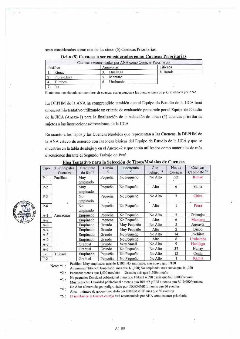
A1-55

A1-56
A1-57

A1-58

A1-59

A1-60

A1-61

A1-62

A1-63

A1-64

A1-65

A1-66

A1-67

A1-68

A1-69

A1-70
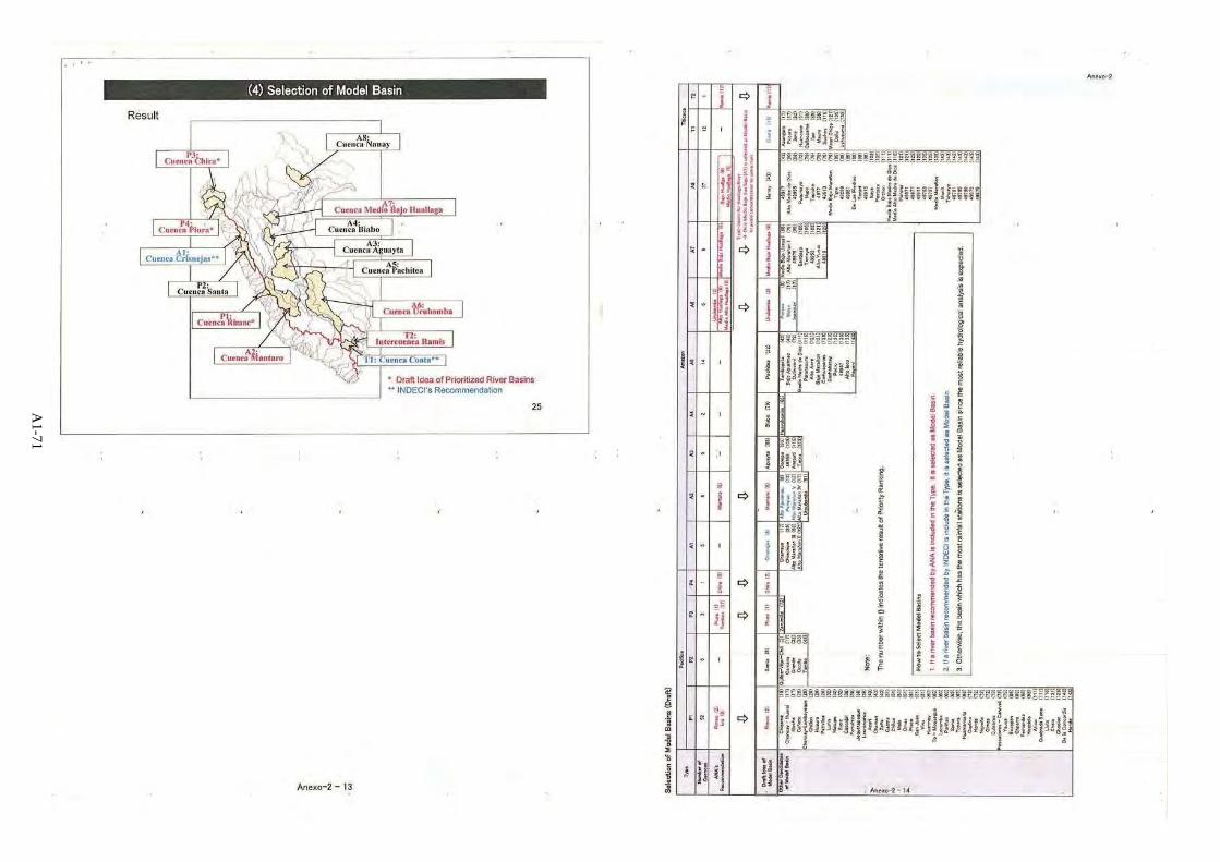
A1-71


Apéndice-1-3 Minuta de la reunión entre ANA y el Equipo de Estudio (2do. Estudio de Campo en Perú)
A1-73

A1-74

A1-75

A1-76

A1-77
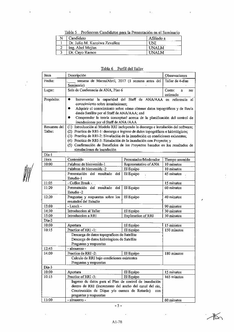
A1-78

A1-79


Apéndice-1-4 Minuta de la reunión entre ANA y el Equipo de Estudio (3er. Estudio de Campo en Perú)
A1-81

A1-82

A1-83

A1-84

A1-85

A1-86

A1-87
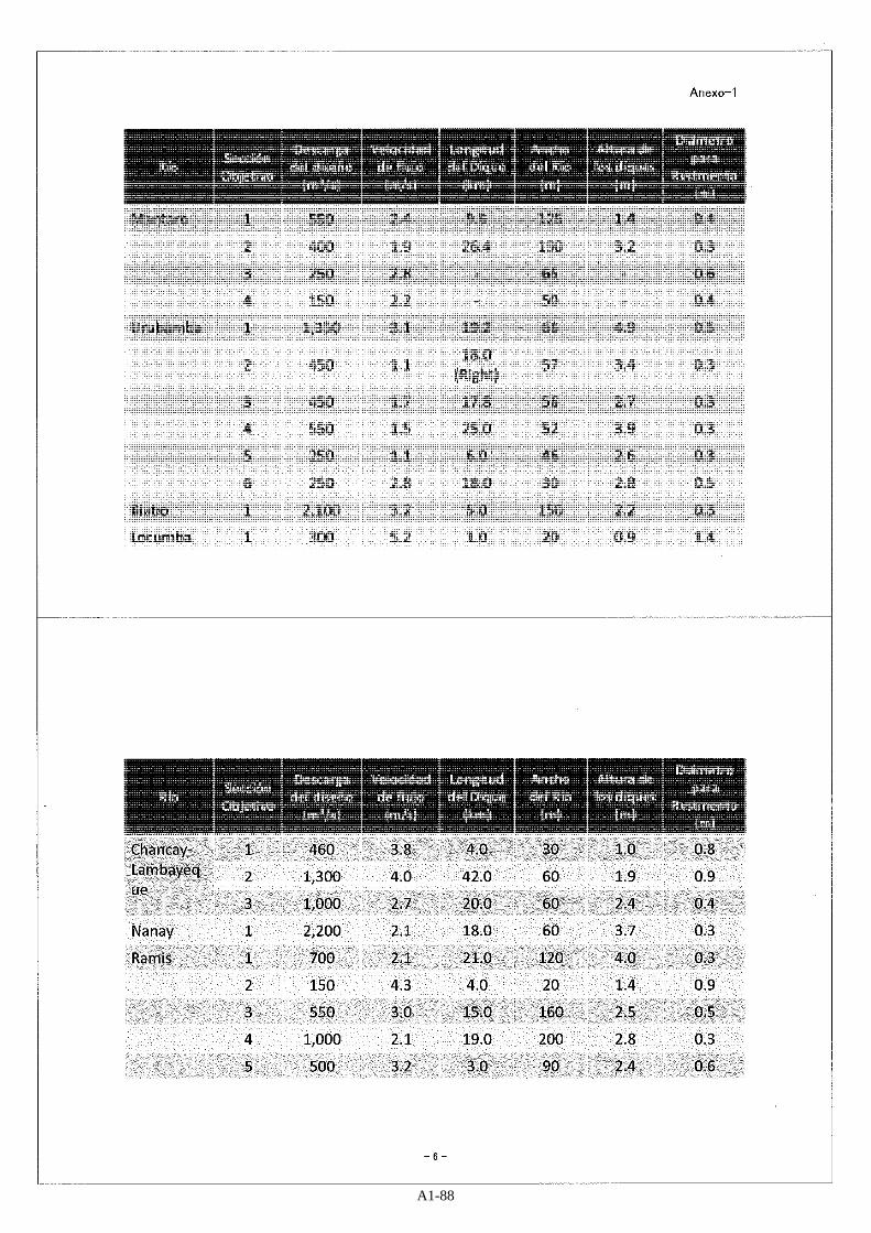
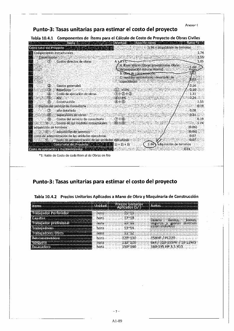
A1-88
A1-89

A1-90

A1-91
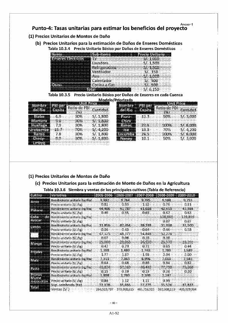
A1-92

A1-93

A1-94

A1-95

A1-96

A1-97

A1-98
A1-99

A1-100

A1-101

A1-102
A1-103
A1-104

A1-105

A1-106
Apéndice-1-5 Minuta de la reunión entre ANA y el Equipo de Estudio (4ta Estudio de Campo en Perú)
A1-107
A1-108

Apéndice-1-6 Recopilación de materiales
A1-109

Tabla A1-6-1 Recopilación de materiales (1/3)
No. Document Name (Remarks, Usage in the Study, etc..) Related River Basins Contents Data Provider
1 Narrowing of the Rimac River due to Anthropogenic Causes-Final Paper.pdf Narrowing of the Rimac River due to Anthropogenic - Kuroiwa_WebRes.pdf Ft Collins_Rock Ramp_Kuroiwa_paper.pdf Mitigacion de Erosion Aguas abajo de Bocatoma Huachipa_5A140.pdf Tampa_De_la_Cruz_Arias_Kuroiwa_Comparison_Erosion_Control_Methods_Steep_Slopes.pdf
Rimac Provided by Dr. Kuroiwa Study on riverbed lowering, river
narrowing, river erosion
Dr.Kuroiwa Universidad Nacional de Ingeniería
2 FORMATOS DE PREVENCION 2014.xls (Number of critical points is about 1,000. The information is used as one of the parameters for estimation of benefit and cost of entire river basins in Peru.)
Whole Country
All critical points of entire country in Peru Study on countermeasures, prjoject
costs, target areas for some rivers.
ANA
3 Technical assistance on early warning systems and flood risk management in relation to El Niño and advice on specific concerns near Ecuadorian/ Peruvian border.doc (The report can be used as referential information for hydrological / hydraulic analysis and study of flood mitigation measures especially for selection of tareget areas, since 3 river basins out of 4 river basins surveyed in the document is candidates of prioritized river basin in the Study)
Rimac Chira/Piura Tumbes Huallaga
Finding report on flood risk for 4 river basins In the report, Dutch government is
considering to install early warning system.
ANA (with support of Dutch Government)
4 NIVEL DEL MAR DE ESTACIONES MAREOGRÁFICAS PATRONES.doc (Although JICA Study Team has requested more detailed data, no additional infomration is not provided yet as of December 2016. In the Study, the provided tidal information is evaluated on a safe side considering its uncertainity.)
― Summary of tidal observation result DHN (Directorate of Hydrography and Navigation)
5 reglamento_delimitacion.pdf (The information explained in the report is used as issues to be considered when carrying out flood mitigation measures in protected areas. So far in the Study, the project areas are not overlapped with protected areas.)
Whole Country
Regulation in the Protected Area ANA
6 EXPO HUAYCOLORO HUACHIPA.pptx (Referred to when considering flood mitigation measures in the Study)
Rimac Rehabilitation works for Quebrada Huaycoloro in Rimac river basin
ALA
7 ESTUDIO RIMAC (wordfile_each Capter) (Referred to when considering flood mitigation measures in the Study)
Rimac Study and planning for flood control and erosion control
ALA
8 Exposicion17.08.2016.pptx Indication of natural retarding area at Casablanca district (shp.file) SERVICIO DE CONSULTORÍA PARA LA ELABORACIÓN DEL ESTUDIO DEFINITIVO
Y EXPEDIENTE TÉCNICO DEL PROYECTO “CONTROL DE DESBORDES E INUNDACIONES EN EL RÍO ICA Y QUEBRADA CANSAS/CHANCHAJALLA Dron_18.08.16
(Referred to when considering flood mitigation measures for Rimac river basin)
Ica Identification of flood prone area in Ica river basin Identification of natural retarding area
at Casablanca, upper area of Ica river basin Project report on “TAMBO
CCARACOCHA” Drone aerial video in Ica river basin
ALA
A1-110

Tabla A1-6-2 Estado de recopilación de materiales (2/3) No. Document Name (Remarks, Usage in the Study, etc..) Related
River Basins Contents Data Provider
9 FICHA DE INTERVENCION DE ZONA VULNERABLE REVISADA final.xls FORMATO DE PREVENCION ZONAS CRITICAS - ALA MANTARO.xls prevencion zonas de emergencia 2015
(Addendum documents to that mentioned in No.2) (Basis for estimation of project costs)
Mantaro Summary of flood vulnerable areas in Mantaro river basin Indication of critical areas to be taken
urgently as of 2015
ALA
10 Resumen Puntos Criticos 2015/2016 da tranferencia.xlsx Document regarding project costs in ALA Cusco, ALA la Convencion, ALA Sicuani
(Addendum documents to that mentioned in No.2) (Basis for estimation of project costs)
Urubamba Critical point,2016 Unit prices and quantities for flood
mitigation works
AAA Urubamba
11 INDECI_1999-2012 Disaster Evaluation (pdf file) INDECI_2010_Cusco_Flood Impact Evaluation
(Basis for estimation of annual average expected amount of damage reduction in Urubamba river basin) (The information might be applied to other river basins since no other reliable damage report which is as detailed as this one exists.)
Urubamba Evaluation of disaster situation during 1999 to 2012 Impact assessment of 2010 flood
INDECI
12 FICHAS DE IDENTIFICACION DE ZONAS VULNERABLES ANTE INUNDACION (Hard Copy) (Addendum documents to that mentioned in No.2) (Basis for estimation of project costs)
Nanay, Itaya, Amazon
Report on critical points and proposed countermeasures including necessary quantities and costs for Nanay, Itaya and other adjacent rivers
ALA Amazonas
13 National Compendium of Statistics on Water Resources (Hard Copy: Book) (Referred to for validation of runoff-inundation analysis to be conducted. However, it should noted that the maximum flow rate indicated in the book is not based on variation on hourly basis.) (Referred to for estimation of flood control capacity of dam operation when considering flood mitigation measures)
Whole Country
Summary of river flow condition and water use situation in major river basins in Peru as of 2014
ALA Amazonas
14 PROTECCION CON ENROCADO EN LA MARGEN DERECHA DEL RIO LOCUMBA SECTOR CHAUCALANA Y DESCOLMATACION DEL RIO SECTOR MAL PASO Y COCOTEA DISTRITO DE LOCUMBA, PROVINCIA DE JORGE BASADRE, DEPARTAMENTO DE TACNA (PDF) (Addendum documents to that mentioned in No.2) (Basis for estimation of project costs)
Locumba Report on critical points and proposed countermeasures including necessary quantities and costs for Locumba
ANA
15 Construccion de la Defensa Riberefia del Rio Llallimayo Margen Derecha Sector Ccotamamani Alto – Distrito Umachiri (PDF) (Addendum documents to that mentioned in No.2) (Basis for estimation of project costs)
Ramis Report on critical points and proposed countermeasures including necessary quantities and costs for Ramis
ANA
16 REGLAMENTO PARA LA DELIMITACION Y MANTENIMIENTO DE FAJAS MARGINALES EN CURSOS FLUVIALES Y CUERPOS DE AGUA NATURALES Y ARTIFICIALES (PDF) (Referred to when considering flood mitigation measures)
- Regulation on the responsibility of setting river boundary. According to the regulation, it is AAA’s responsibility. It was issued by ANA on May 2011.
ANA
A1-111
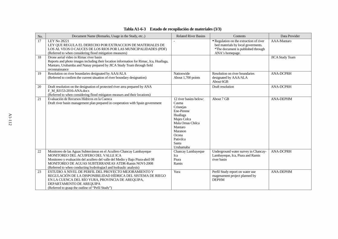
Tabla A1-6-3 Estado de recopilación de materiales (3/3) No. Document Name (Remarks, Usage in the Study, etc..) Related River Basins Contents Data Provider 17 LEY No 28221
LEY QUE REGULA EL DERECHO POR EXTRACCION DE MATERIALES DE LOS AL VEOS O CAUCES DE LOS RIOS POR LAS MUNICIPALIDADES (PDF) (Referred to when considering flood mitigation measures)
- Regulation on the extraction of river bed materials by local goverments. *The document is published through ANA’s homepage.
AAA-Mantaro
18 Drone aerial video in Rimac river basin Reports and photo images including their location information for Rimac, Ica, Huallaga, Mantaro, Urubamba and Nanay prepared by JICA Study Team through field reconnaissance
JICA Study Team
19 Resolution on river boundaries designated by AAA/ALA (Referred to confirm the current situation of river boundary designation)
Nationwide About 1,700 points
Resolution on river boundaries designated by AAA/ALA About 6GB
ANA-DCPRH
20 Draft resolution on the designation of protected river area prepared by ANA F_M_RJ153-2016-ANA.docx (Referred to when considering flood mitigaton measurs and their locations)
Draft resolution ANA-DCPRH
21 Evaluación de Recursos Hídricos en la Cuenca Draft river basin management plan prepared in cooperation with Spain government
12 river basins below: Casma Crisnejas Ene-Perene Huallaga Majes Colca Mala Ornas Chilca Mantaro Maranon Ocona Pativilca Santa Urubamaba
About 7 GB ANA-DEPHM
22 Monitoreo de las Aguas Subterráneas en el Acuífero Chancay Lambayeque MONITOREO DEL ACUIFERO DEL VALLE ICA Monitoreo y evaluación del acuífero del valle del Medio y Bajo Piura-abril 08 MONITOREO DE AGUAS SUBTERRANEAS ATDR-Ramis NOVI-2008 (Referred to when conducting hydrologiacl and hydraulic analysis)
Chancay Lambayeque Ica Piura Ramis
Underground water survey in Chancay-Lambayeque, Ica, Piura and Ramis river basin
ANA-DCPRH
23 ESTUDIO A NIVEL DE PERFIL DEL PROYECTO MEJORAMIENTO Y REGULACIÓN DE LA DISPONIBILIDAD HÍDRICA DEL SISTEMA DE RIEGO EN LA CUENCA DEL RÍO YURA, PROVINCIA DE AREQUIPA, DEPARTAMENTO DE AREQUIPA (Referred to grasp the outline of “Pefil Study”)
Yura Perfil Study report on water use magenament project planned by DEPHM
ANA-DEPHM
A1-112

Apéndice-2-1 Ejemplos de tabla de especificaciones para embalses y reservorios
A2-1

図 貯水池施設の概要(Los Ejidos)
A2-2
k-suzuki
テキストボックス
Figura Información general de la presa de Ejidos

Apéndice-2-2 Registro de gestión del Embalse de Poechos
A2-3

図 管理台帳サンプル(Poechos Dam) 一部抜粋
A2-4

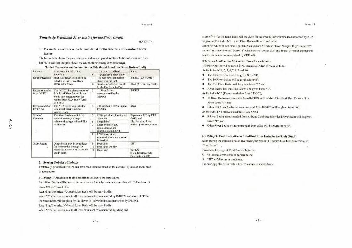
Apéndice-3-1 Dato básico relacionado a evaluación de la vulnerabilidad de inundación
A3-1
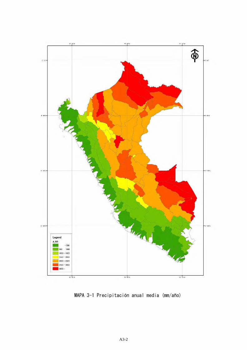
図 添付 3-1.1 年平均降水量(mm/年) MAPA 3-1 Precipitación anual media (mm/año)
A3-2

図 添付 3-1.2 2003 年~2015 年における浸水被害数 MAPA 3-2 Número de casos de daños por inundaciones desde 2003 hasta 2015
A3-3

Note: Affected people were estimated using ANA study family number result which was made for principal river stream. The calculation formula is; Affected people = affected family ×5 (person)
図 添付 3-1.3 過去の浸水被害による被害者数 MAPA 3-3 Número de damnificados por inundaciones pasadas
A3-4

図 添付 3-1.4 PBI(農林水産業) (millions of Soles) MAPA 3-4 PBI (Agricultura, silvicultura y pesca) (Millones de Soles)
A3-5

図 添付 3-1.5 PBI(鉱業) (millions of Soles) MAPA 3-5 PBI (Minería) (Millones de Soles)
A3-6
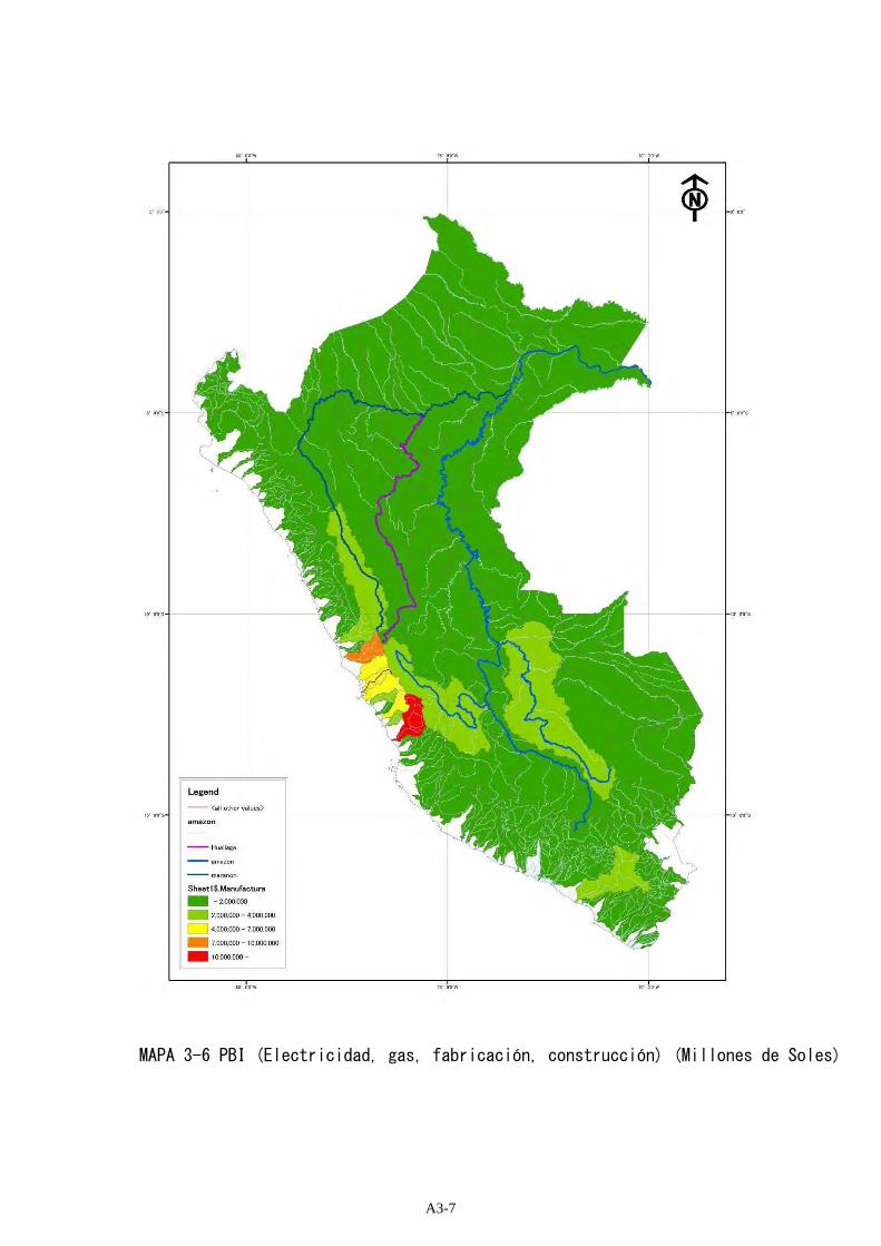
図 添付 3-1.6 PBI(電気・ガス・製造・建設業) (millions of Soles) MAPA 3-6 PBI (Electricidad, gas, fabricación, construcción) (Millones de Soles)
A3-7

図 添付 3-1.7 PBI(運輸・通信・サービス業) (millions of Soles) MAPA 3-7 PBI (Transporte, telecomunicaciones, servicios) (Millones de Soles)
A3-8

図 添付 3-1.8 人口 MAPA 3-8 Población
A3-9
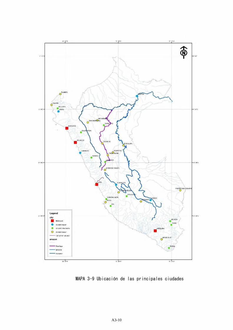
図 添付 3-1.9 主要都市 MAPA 3-9 Ubicación de las principales ciudades
A3-10

表 添付 3-1.1 水害脆弱性の検討結果 脆弱性評価値 23 点以上
No.1 No.2 No.3Score of Flood Vulnerability
No.4 No.5 No.6 No.7 No.8 No.9
All Disaternumber
inundationdisasternumber
TotalPopulation
Populationdensity
affectedfamily
Affectedpeople
Agriculture, Forestry
andFisheries
Oil Gas andMinerals
Manufactura
ServiceInundationdisasternumber
Affectedpeople
Agriculture, Forestry
andFisheries
Oil Gas andMinerals
Manufactura
Service TotalPopulation
Populationdensity
Cities
55 Cuenca Piura 11,019 604 34 4,719,581 428 34,500 172,500 804,252 913,745 1,813,290 1,660,901 ciudad mayor 4 4 4 4 4 4 4 4 3 35 131 Cuenca Rimac 3,504 503 36 5,578,951 1,592 22,210 111,050 576,164 343,966 6,654,180 7,094,989 Metropoli 4 4 4 3 4 4 4 4 4 35 110 Cuenca Quilca - Vitor - Chili 13,549 422 11 990,804 73 22,125 110,625 496,234 1,209,100 1,408,488 1,313,269 Metropoli 3 4 4 4 4 4 4 4 4 35 156 Cuenca Chira 10,679 435 24 510,886 48 721,115 3,605,575 778,914 884,958 1,756,162 1,608,574 ciudad intemedia 4 4 4 4 4 4 4 4 2 34 4133 Cuenca Urubamba 59,071 1811 192 961,127 16 13,990 69,950 1,058,733 6,883,402 2,636,354 2,703,308 ciudad mayor 4 3 4 4 4 4 4 3 3 33 5100' Huallaga 55,109 2786 479 1,077,244 20 20,065 100,325 1,503,360 813,148 1,449,489 1,605,643 cludad menor 4 4 4 4 4 4 4 3 1 32 6143 Cuenca Mantaro 34,547 4842 253 1,681,326 49 14,235 71,175 1,079,958 1,485,916 2,280,633 1,996,557 cludad menor 4 3 4 4 4 4 4 4 1 32 622 Cuenca Ica 7,341 241 12 570,601 78 14,795 73,975 664,598 749,338 1,722,785 831,989 ciudad intemedia 3 3 4 4 4 4 4 4 2 32 643 Cuenca Santa 11,662 420 12 327,010 28 56,320 281,600 755,731 2,658,691 1,496,050 1,219,424 ciudad intemedia 3 4 4 4 4 4 4 3 2 32 6146 Intercuenca Alto Apurimac 34,734 3956 104 513,699 15 30,575 152,875 917,291 2,943,720 1,816,034 1,559,927 cludad menor 4 4 4 4 4 4 4 3 1 32 6120 Cuenca Crisnejas 4,940 525 52 526,598 107 7,330 36,650 355,761 839,286 490,172 451,842 ciudad intemedia 4 3 4 4 3 3 4 4 2 31 11137 Cuenca Perene 18,352 557 63 387,382 21 17,350 86,750 646,650 911,087 965,158 1,277,033 4 4 4 4 4 4 4 3 0 31 11121 Intercuenca Alto Maranon V 21,669 1011 24 559,365 26 6,200 31,000 1,418,715 3,305,686 2,386,726 2,121,623 4 3 4 4 4 4 4 3 0 30 13145 Cuenca Pampas 23,236 3086 108 412,824 18 10,400 52,000 577,134 726,035 769,599 506,553 4 3 4 4 4 4 4 3 0 30 1347 Cuenca Chicama 4,529 132 10 115,025 25 136,850 684,250 542,945 818,301 832,494 774,663 3 4 4 4 4 4 3 3 0 29 1561 Cuenca Tumbes 1,832 296 31 156,823 86 14,835 74,175 160,586 139,914 237,095 317,609 cludad menor 4 4 3 3 3 3 3 4 1 28 16155 Cuenca Coata 4,933 241 33 277,512 56 13,850 69,250 166,452 79,070 155,207 173,928 ciudad intemedia 4 3 3 2 3 3 4 4 2 28 1611 Cuenca Camana 17,153 692 13 92,629 5 16,020 80,100 623,755 1,543,958 1,739,231 1,642,870 3 4 4 4 4 4 3 2 0 28 1633 Cuenca Chancay - Huaral 3,063 14 0 305,977 100 20,235 101,175 503,127 300,422 5,809,249 6,194,146 1 4 4 3 4 4 4 4 0 28 1646 Cuenca Moche 2,132 80 5 965,016 453 18,205 91,025 300,804 395,317 471,813 439,857 2 4 4 4 3 3 4 4 0 28 1669 Cuenca Inambari 20,411 417 52 136,496 7 6,350 31,750 573,982 994,695 704,537 766,410 4 3 4 4 4 4 3 2 0 28 16118 Cuenca Chamaya 8,139 761 29 265,859 33 380 1,900 496,729 1,124,877 795,392 779,161 4 1 4 4 4 4 4 3 0 28 16119 Intercuenca Alto Maranon IV 10,306 654 47 373,371 36 500 2,500 575,729 1,273,713 711,159 654,212 4 1 4 4 4 4 4 3 0 28 16157' Ramis 16,045 670 113 1,894,508 118 1,575 7,875 541,252 257,111 504,686 565,563 0 4 2 4 3 3 4 4 4 0 28 1695 Cuenca Mayo 9,774 647 124 459,951 47 6,805 34,025 283,990 13,768 221,329 218,293 cludad menor 4 3 4 1 3 3 4 4 1 27 2526 Cuenca Canete 6,049 104 14 48,361 8 42,860 214,300 994,942 594,012 11,490,653 12,251,488 3 4 4 4 4 4 2 2 0 27 2532 Cuenca Chillon 2,222 65 11 24,436,544 10,996 0 0 365,482 218,185 4,221,115 4,500,739 3 1 4 3 4 4 4 4 0 27 2534 Cuenca Huaura 4,334 51 3 84,479 19 13,070 65,350 712,651 425,836 8,231,864 8,777,071 2 3 4 4 4 4 3 3 0 27 2536 Cuenca Pativilca 4,602 63 1 50,592 11 39,450 197,250 427,695 840,598 3,781,402 3,940,995 2 4 4 4 4 4 3 2 0 27 2551 Cuenca Chancay-Lambayeque 4,061 120 5 194,221 48 42,460 212,300 266,039 461,241 432,636 555,975 2 4 3 4 3 4 3 4 0 27 25114 Cuenca Chinchipe 6,680 279 12 200,937 30 650 3,250 377,240 1,063,874 511,665 467,700 3 2 4 4 3 4 4 3 0 27 2521 Cuenca Grande 11,050 182 5 105,183 10 5,900 29,500 747,840 899,984 1,788,582 923,386 2 3 4 4 4 4 3 2 0 26 3230 Cuenca Lurin 1,643 49 5 1,434,613 873 0 0 270,369 161,375 3,123,329 3,330,201 2 1 4 3 4 4 4 4 0 26 3235 Cuenca Supe 1,021 10 2 329,775 323 5,430 27,150 168,089 100,327 1,941,779 2,070,391 2 3 3 2 4 4 4 4 0 26 3252 Cuenca Motupe 3,694 162 5 976,160 264 2,450 12,250 307,936 83,107 630,502 975,601 2 2 4 2 4 4 4 4 0 26 32131 Cuenca Pachitea 28,648 263 78 150,507 5 0 0 666,110 2,205,200 757,338 782,554 4 1 4 4 4 4 3 2 0 26 32152 Cuenca Ilave 7,889 151 11 1,696,420 215 1,365 6,825 266,229 126,765 248,778 278,228 3 2 4 3 3 3 4 4 0 26 3212 Cuenca Ocona 15,998 566 5 60,512 4 3,200 16,000 507,342 1,102,008 1,186,610 1,094,732 2 2 4 4 4 4 3 2 0 25 3837 Cuenca Fortaleza 2,353 11 0 65,962 28 9,900 49,500 151,510 509,187 920,803 916,784 1 3 3 4 4 4 3 3 0 25 3842 Cuenca Lacramarca 842 39 1 1,486,697 1,765 7,500 37,500 38,215 201,207 88,105 66,247 ciudad mayor 2 3 2 3 2 2 4 4 3 25 3848 Cuenca Jequetepeque 3,969 342 13 124,404 31 10,950 54,750 237,733 663,538 308,810 283,048 3 3 3 4 3 3 3 3 0 25 3854 Cuenca Cascajal 3,993 65 9 114,525 29 0 0 316,233 191,718 692,058 846,951 3 1 4 3 4 4 3 3 0 25 389 Cuenca Tambo 13,073 539 12 71,156 5 100 500 260,105 1,767,084 3,057,661 613,347 3 1 3 4 4 4 3 2 0 24 43
20 Cuenca Acari 4,316 99 0 450,385 104 23,615 118,075 111,930 210,772 181,251 159,891 1 4 3 3 3 2 4 4 0 24 4349 Cuenca Chaman 1,356 15 1 267,329 197 1,150 5,750 151,624 242,455 229,941 213,771 2 2 3 3 3 3 4 4 0 24 4350 Cuenca Zana 1,763 45 2 69,326 39 23,640 118,200 126,893 149,440 226,253 315,015 2 4 3 3 3 3 3 3 0 24 4365 Cuenca Tambopata 13,467 86 44 63,141 5 0 0 271,312 241,593 264,155 307,864 cludad menor 4 1 4 3 3 3 3 2 1 24 4383 Cuenca Nanay 16,706 277 33 375,454 22 0 0 43,262 127,266 53,958 115,017 ciudad mayor 4 1 2 3 2 2 4 3 3 24 43128 Intercuenca 49917 13,668 234 72 351,309 26 0 0 68,337 40,118 156,095 176,464 ciudad intemedia 4 1 2 2 3 3 4 3 2 24 43144 Intercuenca Bajo Apurimac 6,763 459 30 89,074 13 0 0 155,800 596,000 267,482 251,532 4 1 3 4 3 3 3 2 0 23 5023 Cuenca Pisco 4,231 268 3 157,946 37 4,210 21,050 260,385 302,020 665,243 291,982 2 2 3 3 4 3 3 3 0 23 5024 Cuenca San Juan 3,353 188 6 40,421 12 11,775 58,875 222,832 256,691 573,076 258,861 3 3 3 3 4 3 2 2 0 23 5027 Cuenca Omas 1,117 9 1 146,662 131 0 0 183,871 109,747 2,124,099 2,264,787 2 1 3 2 4 4 3 4 0 23 5028 Cuenca Mala 2,332 36 5 42,543 18 140 700 383,855 229,112 4,434,341 4,728,047 2 1 4 3 4 4 2 3 0 23 5029 Cuenca Chilca 783 1 0 198,576 253 0 0 128,958 76,971 1,489,743 1,588,415 1 1 3 2 4 4 4 4 0 23 5040 Cuenca Casma 2,991 31 0 127,233 43 3,290 16,450 135,662 714,274 312,770 235,172 1 2 3 4 3 3 3 4 0 23 5045 Cuenca Viru 1,926 24 1 98,203 51 0 0 271,802 357,203 426,323 397,449 2 1 4 3 3 3 3 4 0 23 50116 Cuenca Utcubamba 6,650 1139 43 215,420 32 4,500 22,500 187,021 25,536 103,366 95,540 cludad menor 4 3 3 1 2 2 4 3 1 23 50156 Cuenca Huancane 3,660 216 22 85,717 23 34,650 173,250 123,530 58,680 115,184 129,078 4 4 3 2 2 2 3 3 0 23 50
Total Score RankCitiesNo Basin Areakm2
Disaster Population PBI (Miles de nuevos soles)
Resultados de la evaluación de la vulnerabilidad de inundación (más de 23 puntos)
A3-11
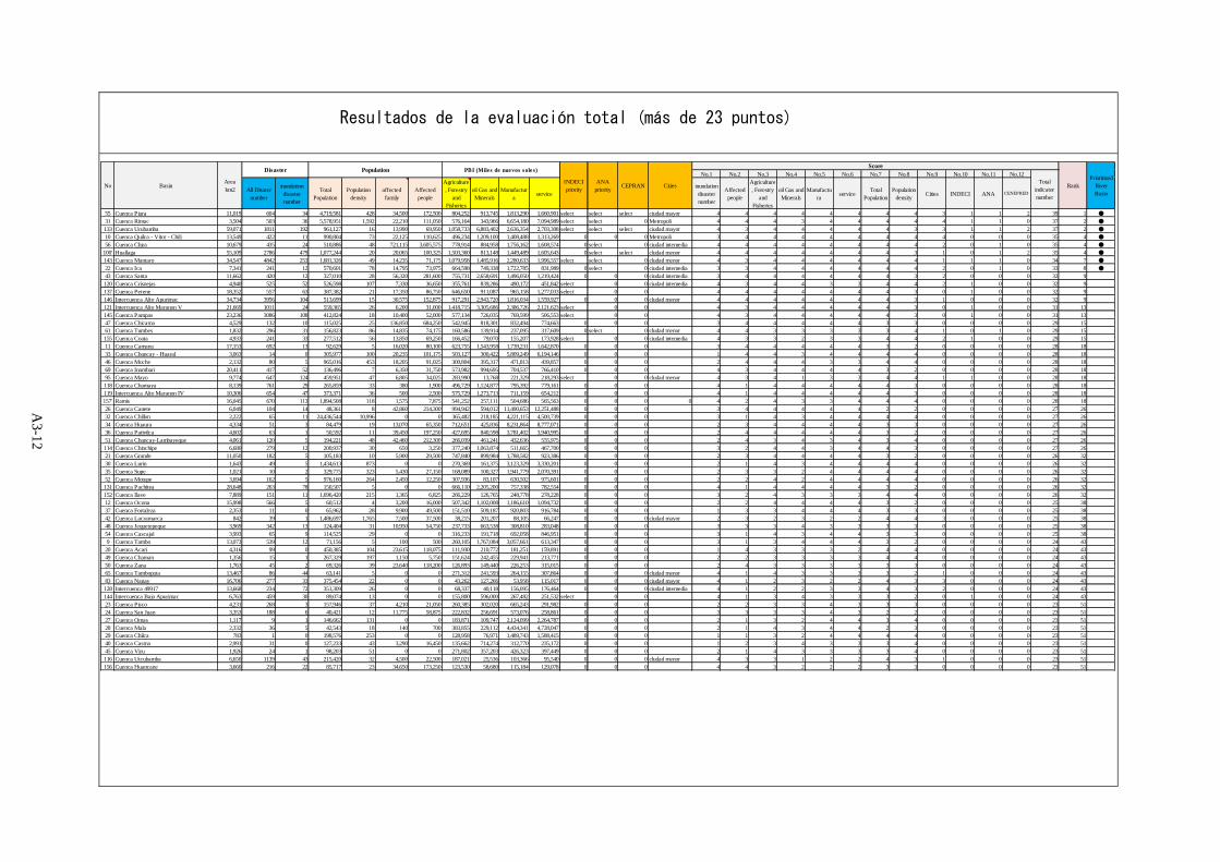
表 添付 3-1.2 総合評価結果(総合評価値 23 点以上)
No.1 No.2 No.3 No.4 No.5 No.6 No.7 No.8 No.9 No.10 No.11 No.12
All Disaternumber
inundationdisasternumber
TotalPopulation
Populationdensity
affectedfamily
Affectedpeople
Agriculture, Forestry
andFisheries
oil Gas andMinerals
Manufactura service
inundationdisasternumber
Affectedpeople
Agriculture, Forestry
andFisheries
oil Gas andMinerals
Manufactura service
TotalPopulation
Populationdensity Cities INDECI ANA CENEPRED
55 Cuenca Piura 11,019 604 34 4,719,581 428 34,500 172,500 804,252 913,745 1,813,290 1,660,901 select select select ciudad mayor 4 4 4 4 4 4 4 4 3 1 1 2 39 1 ●
31 Cuenca Rimac 3,504 503 36 5,578,951 1,592 22,210 111,050 576,164 343,966 6,654,180 7,094,989 select select 0 Metropoli 4 4 4 3 4 4 4 4 4 1 1 0 37 2 ●
133 Cuenca Urubamba 59,071 1811 192 961,127 16 13,990 69,950 1,058,733 6,883,402 2,636,354 2,703,308 select select select ciudad mayor 4 3 4 4 4 4 4 3 3 1 1 2 37 2 ●
10 Cuenca Quilca - Vitor - Chili 13,549 422 11 990,804 73 22,125 110,625 496,234 1,209,100 1,408,488 1,313,269 0 0 0 Metropoli 3 4 4 4 4 4 4 4 4 0 0 0 35 4 ●
56 Cuenca Chira 10,679 435 24 510,886 48 721,115 3,605,575 778,914 884,958 1,756,162 1,608,574 0 select 0 ciudad intemedia 4 4 4 4 4 4 4 4 2 0 1 0 35 4 ●
100' Huallaga 55,109 2786 479 1,077,244 20 20,065 100,325 1,503,360 813,148 1,449,489 1,605,643 0 select select cludad menor 4 4 4 4 4 4 4 3 1 0 1 2 35 4 ●
143 Cuenca Mantaro 34,547 4842 253 1,681,326 49 14,235 71,175 1,079,958 1,485,916 2,280,633 1,996,557 select select 0 cludad menor 4 3 4 4 4 4 4 4 1 1 1 0 34 7 ●
22 Cuenca Ica 7,341 241 12 570,601 78 14,795 73,975 664,598 749,338 1,722,785 831,989 0 select 0 ciudad intemedia 3 3 4 4 4 4 4 4 2 0 1 0 33 8 ●
43 Cuenca Santa 11,662 420 12 327,010 28 56,320 281,600 755,731 2,658,691 1,496,050 1,219,424 0 0 0 ciudad intemedia 3 4 4 4 4 4 4 3 2 0 0 0 32 9120 Cuenca Crisnejas 4,940 525 52 526,598 107 7,330 36,650 355,761 839,286 490,172 451,842 select 0 0 ciudad intemedia 4 3 4 4 3 3 4 4 2 1 0 0 32 9137 Cuenca Perene 18,352 557 63 387,382 21 17,350 86,750 646,650 911,087 965,158 1,277,033 select 0 0 4 4 4 4 4 4 4 3 0 1 0 0 32 9146 Intercuenca Alto Apurimac 34,734 3956 104 513,699 15 30,575 152,875 917,291 2,943,720 1,816,034 1,559,927 0 0 0 cludad menor 4 4 4 4 4 4 4 3 1 0 0 0 32 9121 Intercuenca Alto Maranon V 21,669 1011 24 559,365 26 6,200 31,000 1,418,715 3,305,686 2,386,726 2,121,623 select 0 0 4 3 4 4 4 4 4 3 0 1 0 0 31 13145 Cuenca Pampas 23,236 3086 108 412,824 18 10,400 52,000 577,134 726,035 769,599 506,553 select 0 0 4 3 4 4 4 4 4 3 0 1 0 0 31 1347 Cuenca Chicama 4,529 132 10 115,025 25 136,850 684,250 542,945 818,301 832,494 774,663 0 0 0 3 4 4 4 4 4 3 3 0 0 0 0 29 1561 Cuenca Tumbes 1,832 296 31 156,823 86 14,835 74,175 160,586 139,914 237,095 317,609 0 select 0 cludad menor 4 4 3 3 3 3 3 4 1 0 1 0 29 15155 Cuenca Coata 4,933 241 33 277,512 56 13,850 69,250 166,452 79,070 155,207 173,928 select 0 0 ciudad intemedia 4 3 3 2 3 3 4 4 2 1 0 0 29 1511 Cuenca Camana 17,153 692 13 92,629 5 16,020 80,100 623,755 1,543,958 1,739,231 1,642,870 0 0 0 3 4 4 4 4 4 3 2 0 0 0 0 28 1833 Cuenca Chancay - Huaral 3,063 14 0 305,977 100 20,235 101,175 503,127 300,422 5,809,249 6,194,146 0 0 0 1 4 4 3 4 4 4 4 0 0 0 0 28 1846 Cuenca Moche 2,132 80 5 965,016 453 18,205 91,025 300,804 395,317 471,813 439,857 0 0 0 2 4 4 4 3 3 4 4 0 0 0 0 28 1869 Cuenca Inambari 20,411 417 52 136,496 7 6,350 31,750 573,982 994,695 704,537 766,410 0 0 0 4 3 4 4 4 4 3 2 0 0 0 0 28 1895 Cuenca Mayo 9,774 647 124 459,951 47 6,805 34,025 283,990 13,768 221,329 218,293 select 0 0 cludad menor 4 3 4 1 3 3 4 4 1 1 0 0 28 18118 Cuenca Chamaya 8,139 761 29 265,859 33 380 1,900 496,729 1,124,877 795,392 779,161 0 0 0 4 1 4 4 4 4 4 3 0 0 0 0 28 18119 Intercuenca Alto Maranon IV 10,306 654 47 373,371 36 500 2,500 575,729 1,273,713 711,159 654,212 0 0 0 4 1 4 4 4 4 4 3 0 0 0 0 28 18157' Ramis 16,045 670 113 1,894,508 118 1,575 7,875 541,252 257,111 504,686 565,563 0 0 0 0 4 2 4 3 3 4 4 4 0 0 0 0 28 1826 Cuenca Canete 6,049 104 14 48,361 8 42,860 214,300 994,942 594,012 11,490,653 12,251,488 0 0 0 3 4 4 4 4 4 2 2 0 0 0 0 27 2632 Cuenca Chillon 2,222 65 11 24,436,544 10,996 0 0 365,482 218,185 4,221,115 4,500,739 0 0 0 3 1 4 3 4 4 4 4 0 0 0 0 27 2634 Cuenca Huaura 4,334 51 3 84,479 19 13,070 65,350 712,651 425,836 8,231,864 8,777,071 0 0 0 2 3 4 4 4 4 3 3 0 0 0 0 27 2636 Cuenca Pativilca 4,602 63 1 50,592 11 39,450 197,250 427,695 840,598 3,781,402 3,940,995 0 0 0 2 4 4 4 4 4 3 2 0 0 0 0 27 2651 Cuenca Chancay-Lambayeque 4,061 120 5 194,221 48 42,460 212,300 266,039 461,241 432,636 555,975 0 0 0 2 4 3 4 3 4 3 4 0 0 0 0 27 26114 Cuenca Chinchipe 6,680 279 12 200,937 30 650 3,250 377,240 1,063,874 511,665 467,700 0 0 0 3 2 4 4 3 4 4 3 0 0 0 0 27 2621 Cuenca Grande 11,050 182 5 105,183 10 5,900 29,500 747,840 899,984 1,788,582 923,386 0 0 0 2 3 4 4 4 4 3 2 0 0 0 0 26 3230 Cuenca Lurin 1,643 49 5 1,434,613 873 0 0 270,369 161,375 3,123,329 3,330,201 0 0 0 2 1 4 3 4 4 4 4 0 0 0 0 26 3235 Cuenca Supe 1,021 10 2 329,775 323 5,430 27,150 168,089 100,327 1,941,779 2,070,391 0 0 0 2 3 3 2 4 4 4 4 0 0 0 0 26 3252 Cuenca Motupe 3,694 162 5 976,160 264 2,450 12,250 307,936 83,107 630,502 975,601 0 0 0 2 2 4 2 4 4 4 4 0 0 0 0 26 32131 Cuenca Pachitea 28,648 263 78 150,507 5 0 0 666,110 2,205,200 757,338 782,554 0 0 0 4 1 4 4 4 4 3 2 0 0 0 0 26 32152 Cuenca Ilave 7,889 151 11 1,696,420 215 1,365 6,825 266,229 126,765 248,778 278,228 0 0 0 3 2 4 3 3 3 4 4 0 0 0 0 26 3212 Cuenca Ocona 15,998 566 5 60,512 4 3,200 16,000 507,342 1,102,008 1,186,610 1,094,732 0 0 0 2 2 4 4 4 4 3 2 0 0 0 0 25 3837 Cuenca Fortaleza 2,353 11 0 65,962 28 9,900 49,500 151,510 509,187 920,803 916,784 0 0 0 1 3 3 4 4 4 3 3 0 0 0 0 25 3842 Cuenca Lacramarca 842 39 1 1,486,697 1,765 7,500 37,500 38,215 201,207 88,105 66,247 0 0 0 ciudad mayor 2 3 2 3 2 2 4 4 3 0 0 0 25 3848 Cuenca Jequetepeque 3,969 342 13 124,404 31 10,950 54,750 237,733 663,538 308,810 283,048 0 0 0 3 3 3 4 3 3 3 3 0 0 0 0 25 3854 Cuenca Cascajal 3,993 65 9 114,525 29 0 0 316,233 191,718 692,058 846,951 0 0 0 3 1 4 3 4 4 3 3 0 0 0 0 25 389 Cuenca Tambo 13,073 539 12 71,156 5 100 500 260,105 1,767,084 3,057,661 613,347 0 0 0 3 1 3 4 4 4 3 2 0 0 0 0 24 43
20 Cuenca Acari 4,316 99 0 450,385 104 23,615 118,075 111,930 210,772 181,251 159,891 0 0 0 1 4 3 3 3 2 4 4 0 0 0 0 24 4349 Cuenca Chaman 1,356 15 1 267,329 197 1,150 5,750 151,624 242,455 229,941 213,771 0 0 0 2 2 3 3 3 3 4 4 0 0 0 0 24 4350 Cuenca Zana 1,763 45 2 69,326 39 23,640 118,200 126,893 149,440 226,253 315,015 0 0 0 2 4 3 3 3 3 3 3 0 0 0 0 24 4365 Cuenca Tambopata 13,467 86 44 63,141 5 0 0 271,312 241,593 264,155 307,864 0 0 0 cludad menor 4 1 4 3 3 3 3 2 1 0 0 0 24 4383 Cuenca Nanay 16,706 277 33 375,454 22 0 0 43,262 127,266 53,958 115,017 0 0 0 ciudad mayor 4 1 2 3 2 2 4 3 3 0 0 0 24 43128 Intercuenca 49917 13,668 234 72 351,309 26 0 0 68,337 40,118 156,095 176,464 0 0 0 ciudad intemedia 4 1 2 2 3 3 4 3 2 0 0 0 24 43144 Intercuenca Bajo Apurimac 6,763 459 30 89,074 13 0 0 155,800 596,000 267,482 251,532 select 0 0 4 1 3 4 3 3 3 2 0 1 0 0 24 4323 Cuenca Pisco 4,231 268 3 157,946 37 4,210 21,050 260,385 302,020 665,243 291,982 0 0 0 2 2 3 3 4 3 3 3 0 0 0 0 23 5124 Cuenca San Juan 3,353 188 6 40,421 12 11,775 58,875 222,832 256,691 573,076 258,861 0 0 0 3 3 3 3 4 3 2 2 0 0 0 0 23 5127 Cuenca Omas 1,117 9 1 146,662 131 0 0 183,871 109,747 2,124,099 2,264,787 0 0 0 2 1 3 2 4 4 3 4 0 0 0 0 23 5128 Cuenca Mala 2,332 36 5 42,543 18 140 700 383,855 229,112 4,434,341 4,728,047 0 0 0 2 1 4 3 4 4 2 3 0 0 0 0 23 5129 Cuenca Chilca 783 1 0 198,576 253 0 0 128,958 76,971 1,489,743 1,588,415 0 0 0 1 1 3 2 4 4 4 4 0 0 0 0 23 5140 Cuenca Casma 2,991 31 0 127,233 43 3,290 16,450 135,662 714,274 312,770 235,172 0 0 0 1 2 3 4 3 3 3 4 0 0 0 0 23 5145 Cuenca Viru 1,926 24 1 98,203 51 0 0 271,802 357,203 426,323 397,449 0 0 0 2 1 4 3 3 3 3 4 0 0 0 0 23 51116 Cuenca Utcubamba 6,650 1139 43 215,420 32 4,500 22,500 187,021 25,536 103,366 95,540 0 0 0 cludad menor 4 3 3 1 2 2 4 3 1 0 0 0 23 51156 Cuenca Huancane 3,660 216 22 85,717 23 34,650 173,250 123,530 58,680 115,184 129,078 0 0 0 4 4 3 2 2 2 3 3 0 0 0 0 23 51
PrioritizedRiverBasin
Totalindicatornumber
Score
RankAreakm2 Cities
ANApriorityBasinNo CEPRAN
INDECIpriority
PBI (Miles de nuevos soles)PopulationDisaster
Resultados de la evaluación total (más de 23 puntos)
A3-12

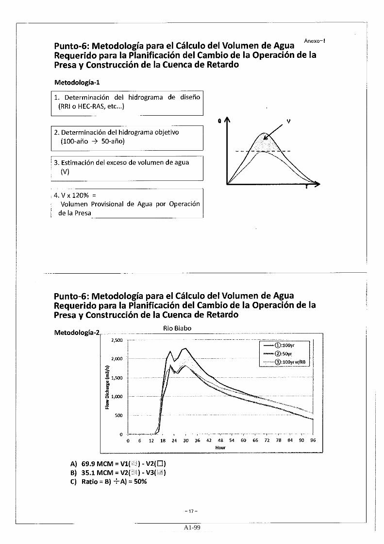
Apéndice-4-1 Resultados del Análisis de Inundación- Escorrentía (Biabo)
A4-1

CUZCO
NUEVO LIMA
Legend
Capitales_emi_rev_join
ORDEN, CATEGORIA
97, Capital distrital
biabo_pop
VALUE
0 - 100
100 -
Out_hsmax_50.txt
<VALUE>
0 - 0.1
0.1 - 0.5
0.5 - 1.0
1.0 - 2.0
2.0 - 3.0
3.0 -
10 0 105 km
Río Biabo, en caso de precipitación de 50 años
A4-2

CUZCO
NUEVO LIMA
Legend
Capitales_emi_rev_join
ORDEN, CATEGORIA
97, Capital distrital
biabo_pop
VALUE
0 - 100
100 -
Out_hsmax_25.txt
<VALUE>
0 - 0.1
0.1 - 0.5
0.5 - 1.0
1.0 - 2.0
2.0 - 3.0
3.0 -
10 0 105 km
Río Biabo, en caso de precipitación de 25 años
A4-3

CUZCO
NUEVO LIMA
Legend
Capitales_emi_rev_join
ORDEN, CATEGORIA
97, Capital distrital
biabo_pop
VALUE
0 - 100
100 -
Out_hsmax_10.txt
<VALUE>
0 - 0.1
0.1 - 0.5
0.5 - 1.0
1.0 - 2.0
2.0 - 3.0
3.0 -
10 0 105 km
Río Biabo, en caso de precipitación de 10 años
A4-4

CUZCO
NUEVO LIMA
Legend
Capitales_emi_rev_join
ORDEN, CATEGORIA
97, Capital distrital
biabo_pop
VALUE
0 - 100
100 -
Out_hsmax_5.txt
<VALUE>
0 - 0.1
0.1 - 0.5
0.5 - 1.0
1.0 - 2.0
2.0 - 3.0
3.0 -
10 0 105 km
Río Biabo, en caso de precipitación de 5 años
A4-5

CUZCO
NUEVO LIMA
Legend
Capitales_emi_rev_join
ORDEN, CATEGORIA
97, Capital distrital
biabo_pop
VALUE
0 - 100
100 -
Out_hsmax_2.txt
<VALUE>
0 - 0.1
0.1 - 0.5
0.5 - 1.0
1.0 - 2.0
2.0 - 3.0
3.0 -
10 0 105 km
Río Biabo, en caso de precipitación de 2 años
A4-6